City of Rivergrove Documents
Welcome to the official digital repository of City of Rivergrove municipal documents.
Browse Documents by Type
Quick Search
Use the search box in the sidebar or press / to search across all documents.
Document Status
This is an ongoing digitization project. Documents are being added regularly as they are processed from the city’s archives. Each document has been carefully transcribed from original sources to ensure accuracy and searchability.
Contact
For questions about specific documents or to report any issues, please reach out to Leah. If you are more tech savy, Pull Requests and Issues are welcome in the public repo!
This repository is maintained as part of Rivergrove Council Member Leah Silber’s personal commitment to transparency and public access to government records.
CITY OF RIVERGROVE, OREGON CHARTER
Originally Adopted by the Voters
November 5, 1974
Incorporated March 11, 1971
This version was retyped and digitally formatted in April 2025 from a typewritten archival copy maintained in the city’s legislative records. While the structure and formatting have been updated for digital access — including the addition of a Table of Contents — the text remains verbatim to the original.
TABLE OF CONTENTS
CHAPTER I - NAME AND BOUNDARIES
- Section 1. Title of Enactment
- Section 2. Name of City
- Section 3. Boundaries
CHAPTER II - POWERS
- Section 4. Powers of the City
- Section 5. Construction of Charter
CHAPTER III - FORM OF GOVERNMENT
- Section 6. Where Powers Vested
- Section 7. Council
- Section 8. Councilmen
- Section 9. Mayor
- Section 10. Other Officers
- Section 11. Salaries
- Section 12. Qualifications of Officers
CHAPTER IV - COUNCIL
- Section 13. Meetings
- Section 14. Quorum
- Section 15. Record of Proceedings
- Section 16. Proceedings to be Public
- Section 17. Mayor’s Functions at Council Meetings
- Section 18. President of the Council
- Section 19. Vote Required
CHAPTER V - POWERS AND DUTIES OF OFFICERS
- Section 20. Mayor
- Section 21. Municipal Judge
- Section 22. Recorder
CHAPTER VI - ELECTIONS
- Section 23. Regular Elections
- Section 24. Notice of Regular Elections
- Section 25. Special Elections
- Section 26. Regulation of Elections
- Section 27. Canvass of Returns
- Section 28. Tie Votes
- Section 29. Commencement of Terms of Office
- Section 30. Oath of Office
- Section 31. Nominations
CHAPTER VII - VACANCIES IN OFFICE
- Section 32. What Creates Vacancy
- Section 33. Filling of Vacancies
CHAPTER VIII - ORDINANCES
- Section 34. Enacting Clause
- Section 35. Mode of Enactment
- Section 36. When Ordinances Take Effect
CHAPTER IX - PUBLIC IMPROVEMENTS
- Section 37. Condemnation
- Section 38. Improvements
- Section 39. Special Assessments
- Section 40. Bids
- Section 41. Debt Limit
- Section 42. Torts
- Section 43. Existing Ordinances Continued
- Section 44. Repeal of Previously Enacted Provisions
- Section 45. Amendment
- Section 46. Time of Effect of Charter
CHARTER OF THE CITY OF RIVERGROVE
To provide for the government of the city of Rivergrove, Clackamas County, Oregon; and to repeal all charter provisions of the city enacted prior to the time that this charter takes effect.
Be it enacted by the people of the city of Rivergrove, Clackamas County, Oregon:
CHAPTER I
NAME AND BOUNDARIES
Section 1. Title of Enactment.
This enactment may be referred to as the Rivergrove City Charter of 1974.
Section 2. Name of City.
The municipality of Rivergrove, Clackamas County, Oregon, shall continue to be a municipal corporation with the name “City of Rivergrove.”
Section 3. Boundaries.
The city shall include all territory encompassed by its’ boundaries as they now exist or hereafter are modified by voters, by the council, or by any other agency with legal power to modify them. The recorder shall keep in his office at least two copies of this charter in each of which he shall maintain an accurate, up-to-date description of the boundaries. The copies and descriptions shall be available for public inspection at any time during regular office hours of the recorder.
CHAPTER II
POWERS
Section 4. Powers of the City.
The city shall have all powers which the constitutions, statutes, and common law of the United States and of this state expressly or impliedly grant or allow municipalities, as fully as though this charter specifically enumerated each of those powers.
Section 5. Construction of Charter.
In this charter no mention of a particular power shall be construed to be exclusive or to restrict the scope of the powers which the city would have if the particular power were not mentioned. The charter shall be literally, construed to the end that the city may have all powers necessary or convenient for the conduct of its municipal affairs, including all powers that cities may assume pursuant to state laws and to the municipal home rule provisions of the state constitution.
CHAPTER III
FORM OF GOVERNMENT
Section 6. Where Powers Vested.
Except as this charter provides otherwise, all powers of the city shall be vested in the council.
Section 7. Council.
The council shall be composed of a mayor and four councilmen elected from the city at large.
Section 8. Councilmen.
The term of office of each councilman in office when this charter is adopted shall continue until the beginning of the first odd-numbered year after that time. At the first biennial general election after the charter is adopted, five councilmen shall be elected. Of the five, the two receiving the two highest numbers of votes shall each hold office for four years, and the three receiving the next three highest numbers of votes shall each hold office for two years. At each subsequent biennial general election, three councilmen shall be elected. Of the three, the two receiving the two highest numbers of votes shall each hold office for four years, and the one receiving the third highest number of votes shall hold office for two years.
Section 9. Mayor.
At its first meeting of each odd-numbered year, the council shall choose from its membership a chairman, who shall be mayor. The mayor’s term of office shall be two years.
Section 10. Other Officers.
Additional officers of the city shall be a municipal judge, a recorder, and such other officers as the council deems necessary. Each of these officers shall be appointed and may be removed by the mayor with the consent of the council. The council may combine any two or more appointive city offices. The council may designate any appointive officer to supervise any other appointive officer except the municipal judge in the exercise of his judicial functions.
Section 11. Salaries.
The compensation for the services of each city officer and employe shall be the amount fixed by the council.
Section 12. Qualifications of Officers.
No person shall be eligible for an elective office of the city unless at the time of his election he is a qualified elector within the meaning of the state constitution and has resided in the city during the six months immediately preceding the election. The council shall be final judge of the qualifications and election of its own members.
CHAPTER IV
COUNCIL
Section 13. Meetings.
The council shall hold a regular meeting least once each month in or near the city at a time and at a place which it designates. It shall adopt rules for the government of its members and proceedings. The mayor, upon his own motion may, or at the request of two members of the council shall, by giving notice thereof to all members of the council then in the city, call a special meeting of the council for a time not earlier than twenty-four hours after the notice is given. Special meetings of the council may also be held at any time by the common consent of all members of the council. This section is not intended to limit in any way the calling of special meetings in case of a true emergency.
Section 14. Quorum.
A majority of members of the council shall constitute a quorum for its business, but a smaller number may meet and compel the attendance of absent members in a manner provided by ordinance.
Section 15. Record of Proceedings.
The council shall cause a record of its proceedings to be kept. Upon the request of any of its members, the ayes and nays upon any question before it shall be taken and entered in the record.
Section 16. Proceedings to be Public.
No action by the council shall have legal effect unless the motion for the action and the vote by which it is disposed of take place at proceedings open to the public.
Section 17. Mayor’s Functions at Council Meetings.
The mayor shall be chairman of the council and preside over its deliberations. He shall have a vote on all questions before it. He shall have authority to preserve order, enforce the rules of the council, and determine the order of business under the rules of the council.
Section 18. President of the Council.
Its first meeting after this charter takes effect and thereafter at its first meeting of each odd-numbered year, the council by ballot shall elect a president from its membership. In the mayor’s absence from a council meeting, the president shall preside over it. Whenever the mayor is unable to perform the functions of his office, the president shall act as mayor.
Section 19. Vote Required.
Except as this charter otherwise provides, the concurrence of a majority of the members of the council present at a council meeting shall be necessary to decide any question before the council.
Chapter V
POWERS AND DUTIES OF OFFICERS
Section 20. Mayor.
The mayor shall appoint the committees provided by the rules of the council. He shall sign all records of proceedings approved by the council and countersign all orders on the treasury. He shall have no veto power and shall sign all ordinances passed by the council within three days after their passage. After the council approves a bond of a city officer or a bond for a license, contract, or proposal, the mayor shall endorse the bond.
Section 21. Municipal Judge.
There is hereby established a municipal court for the City of Rivergrove. The municipal judge shall be the judicial officer of the city. The court shall be open for the transaction of judicial business at times specified by the council, All area within the city shall be within the territorial jurisdiction of the court. The municipal judge shall exercise original and exclusive jurisdiction of all offenses defined and made punishable by ordinances of the city and of all actions brought to recover or enforce forfeitures or penalties defined or authorized by ordinances of the city. He shall have authority to issue process for the arrest of any person accused of an offense against the ordinances of the city, to commit any such person to jail or admit him to bail pending trial, to issue subpoenas, to compel witnesses to appear and testify in court on the trial of any cause before him, to compel obedience to such subpoenas, to issue any process necessary to carry into effect the judgments of the court, and to punish witnesses and others for contempt of court. When not governed by ordinances or this charter, all proceedings in the municipal court for the violation of a city ordinance shall be governed by the applicable general laws of the state governing justices of the peace and justice courts,
Section 22. Recorder.
The recorder shall serve ex officio as clerk of the council, attend all its meetings unless excused therefrom by the council, keep an accurate record of its proceedings, and sign all orders on the treasury. In the recorder’s absence from a council meeting, the mayor shall appoint a clerk of the council pro tem who, while acting in that capacity, shall have all the authority and duties of the recorder.
Chapter VI
ELECTIONS
Section 23. Regular Elections.
Regular city elections shall be held at the same times and places as biennial general elections, in accordance with applicable state election laws.
Section 24. Notice of Regular Elections.
The recorder, pursuant to directions from the council, shall give at least ten days’ notice of each regular city election by posting notice thereof at a conspicuous place in the city hall and in one public place in each voting precinct of the city. The notice shall state the officers to be elected, the ballot title of each measure to be voted upon, and the time and place of the election.
Section 25. Special Elections.
The council shall provide the time, manner, and means for holding any special election. The recorder shall give at least ten days’ notice of each special election in the manner provided by the action of the council ordering the election.
Section 26. Regulation of Elections.
Except as this charter provides otherwise and as the council provides otherwise by ordinances relating to elections, the general laws of the state shall apply to the conduct of all city elections, recounts of the returns therefrom, and contests thereof.
Section 27. Canvass of Returns.
In all elections held in conjunction with state and county elections, the state laws governing the filing of returns by the county clerk shall apply. In each special city election the returns therefrom shall be filed with the recorder on or before noon of the day following, and not later than five days after the election the council shall meet and canvass the returns. The results of all elections shall be entered in the record of the proceedings of the council. The entry shall state the total number of votes cast at the election, the votes cast for each person and for and against each proposition, the name of each person elected to office, the office to which he has been elected, and a reference to each measure enacted or approved. Immediately after the canvass is completed, the recorder shall make and sign a certificate of election of each person elected and deliver the certificate to him within one day after the canvass. A certificate so made and delivered shall be prima facie evidence of the truth of the statements contained in it.
Section 28. Tie Votes.
In the event of a tie vote for candidates for an elective office, the successful candidate shall be determined by a public drawing of lots in a manner prescribed by the council.
Section 29. Commencement of Terms of Office.
The term of office of a person elected at a regular city election shall commence the first of the year immediately following the election.
Section 30. Oath of Office.
Before entering upon the duties of his office, each officer shall take an oath or shall affirm that he will support the constitutions and laws of the United States and of Oregon and that he will faithfully perform the duties of his office.
Section 31. Nominations.
A qualified elector who has resided in the city during the six months immediately preceding an election may be nominated for an elective city office to be filled at the election. The nomination shall be by a petition that specifies the office sought and shall be in a form prescribed by the council. The petition shall be signed by not fewer than 20 electors. No elector shall sign more than one petition for each office to be filled at the election. If he does so, his signature shall be valid only on the first sufficient petition filed for the office. The signatures to a nomination petition need not all be appended to one paper, but to each separate paper of the petition shall be attached an affidavit of the circulator thereof, indicating the number of signers of the paper and stating that each signature appended thereto was made in his presence and is the genuine signature of the person whose name it purports to be. Opposite each signature shall be stated the signer’s place of residence, identified by its street and number or other sufficient designation. All nomination papers comprising a petition shall be assembled and filed with the recorder as one instrument not earlier than 100 nor later than 70 days before the election. The recorder shall make a record of the exact time at which each petition is filed and shall take and preserve the name and address of the person by whom it is filed. If the petition is not signed by the required number of qualified electors, the recorder shall notify the candidate and the person who filed the petition within five days after the filing. If the petition is insufficient in any other particular, the recorder shall return it immediately to the person who filed it, certifying in writing wherein the petition is insufficient. The deficient petition may be amended and filed again as a new petition, or a substitute petition for the same candidate may be filed, within the regular time for filing nomination petitions. The recorder shall notify an eligible person of his nomination, and that person shall file with the recorder his written acceptance of nomination, in such form as the council may require, within five days of notification of nomination. Upon receipt of the acceptance of nomination, the recorder shall cause the nominee’s name to be printed on the ballots. The petition of nomination for a successful candidate at an election shall be preserved in the office of the recorder until the term of office for which the candidate is elected expires.
Chapter VII
VACANCIES IN OFFICE
Section 32. What Creates Vacancy.
An office shall be deemed vacant upon the incumbent’s death; adjudicated incompetence; conviction of a felony, other offense pertaining to his office, or unlawful destruction of public records; resignation; recall from office; or ceasing to possess the qualifications for the office; upon the failure of the person elected or appointed to the office to qualify therefor within ten days after the time for his term of office to commence; or in the case of a mayor or councilman, upon his absence from two or more regular, consecutive council meetings without reasonable justification, and upon a declaration by the council of the vacancy. The city council shall make a declaration of what constitutes reasonable justification.
Section 33. Filling of Vacancies.
Vacant elective offices in the city shall be filled by appointment by the mayor. A majority vote of the council shall be required to confirm the appointment. The appointee’s term of office shall begin immediately upon his confirmation and shall continue throughout the unexpired term of his predecessor. During the temporary disability of any officer or during his absence temporarily from the city for any cause, his office may be filled pro tem in the manner provided for filling vacancies in office permanently.
Chapter VIII
ORDINANCES
Section 34. Enacting Clause.
The enacting clause of all ordinances hereafter enacted shall be, “The city of Rivergrove ordains as follows:”
Section 35. Mode of Enactment.
-
Except as the second and third paragraphs of this section provide to the contrary, every ordinance of the council shall, before being put upon its final passage, be read fully and distinctly in open council meeting on two different days.
-
Except as the third paragraph of this section provides to the contrary, an ordinance may be enacted at a single meeting of the council by unanimous vote of all council members present, upon being read first in full and then by title.
-
Any of the readings may be by title only if no council member present at the meeting requests to have the ordinance read in full or if a copy of the ordinance is provided for each council member and three copies are provided for public inspection in the office of the city recorder not later than one week before the first reading of the ordinance and if notice of their availability is given forthwith upon the filing, by written notice posted at the city hall and two other public places in the city or by advertisement in a newspaper of general circulation in the city. An ordinance enacted after being read by title alone may have no legal effect if it differs substantially from its terms as it was thus filed prior to such reading, unless each section incorporating such difference is read fully and distinctly in open council meeting as finally amended prior to being approved by the council.
-
Upon the final vote on an ordinance, the ayes and nays of the members shall be taken and entered in the record of proceedings.
-
Upon the enactment of an ordinance the recorder shall sign it with the date of its passage and his name and title of office, and within three days thereafter the mayor shall sign it with the date of his signature, his name and the title of his office.
Section 36. When Ordinances Take Effect.
An ordinance enacted by the council shall take effect on the thirtieth day after its enactment. When the council deems it advisable, however, an ordinance may provide a later time for it to take effect, and in case of an emergency, it may take effect immediately.
Chapter IX
PUBLIC IMPROVEMENTS
Section 37. Condemnation.
Any necessity of taking property for the city by condemnation shall be determined by the council and declared by a resolution of the council describing the property and stating the uses to which it shall be devoted.
Section 38. Improvements.
The procedure for making, altering, vacating, or abandoning a public improvement shall be governed by general ordinance or, to the extent not so governed, by the applicable general laws of the state. Action on any proposed public improvement, except a sidewalk or except an improvement unanimously declared by the council to be needed at once because of an emergency, shall be suspended for six months upon a remonstrance thereto by the owners of two-thirds of the land to be specially assessed therefor. Joint owners of land must be in unanimous agreement for inclusion of their land in the two-thirds rule. In this section “owner” shall mean the record holder of legal title or, where land is being purchased under a land sale contract recorded or verified to the recorder in writing by the record holder of legal title to the land, the purchaser shall be deemed the “owner.”
Section 39. Special Assessments.
The procedure for levying, collecting, and enforcing the payment of special assessments for public improvements or other services to be charged against real property shall be governed by general ordinance.
Section 40. Bids.
A contract in excess of $250.00 for a public improvement to be made by a private contractor shall be let to the lowest responsible bidder for the contract and shall be done in accordance with plans and specifications approved by the council.
Section 41. Debt Limit.
Except by consent of the voters, the city’s voluntary floating indebtedness shall not exceed 1% of the assessed valuation of the city; nor its bonded indebtedness exceed 3% at any one time. For purposes of calculating the limitation, however, the legally authorized debt of the city in existence at the time this charter takes effect shall not be considered. All city officials and employees who create or officially approve any indebtedness in excess of this limitation shall be jointly and severally liable for the excess.
Section 42. Torts.
In no event shall the city be liable in damages for an injury to person, a damage to property, or a death, caused by a defect or a dangerous condition in a public thoroughfare, site, or facility, unless the city has had actual notice prior to the injury, damage, or death that the defect or condition existed and has had a reasonable time thereafter in which to repair or remove it. In no case shall more than $500 be recovered as damages for an injury, damage, or death resulting from such a defect or dangerous place. No action shall be maintained against the city for damages growing out of such injury, damage, or death unless the claimant first gives written notice to the council, within the time limitations provided by Oregon statute, after the injury, damage, or death is sustained, stating specifically the time when, the place where, and the circumstances under which it was sustained, and that he will claim damages therefor of the city in an amount which he specifies. But in no event shall the action be started until 60 days have elapsed after the presentation of this notice to the council.
Section 43. Existing Ordinances Continued.
All ordinances of the city consistent with this charter and in force when it takes effect shall remain in effect until amended or repealed.
Section 44. Repeal of Previously Enacted Provisions.
All charter provisions of the city enacted prior to the time that this charter takes effect are hereby repealed.
Section 45. Amendment.
-
This charter may be amended by the voters at a regular or special election.
-
An ordinance to refer an amendment to the voters shall be adopted at least 60 calendar days before the election at which the measure is to be voted upon and shall be effective upon the signature of the presiding officer of the council.
-
An initiative petition proposing a charter amendment shall be filed with the officer in charge of elections at least 90 calendar days before the election at which the measure is to come before the voters. If a petition is filed and the council calls a special election on the measure, the election may not be held sooner than 90 calendar days after the call.
Section 46. Time of Effect of Charter.
This charter shall take effect 30 days after approval by the voters.
EXHIBIT A
ORDINANCE NO. XVI
AN ORDINANCE ESTABLISHING A PARK ADVISORY COUNCIL
THE CITY OF RIVERGROVE DOES ORDAIN AS FOLLOWS:
-
A Park Advisory Council is hereby established for the City of Rivergrove.
-
The Park Advisory Council shall consist of three members to be appointed by the mayor with the approval of the City Council. The term of the members thereof shall be for a period of two years except that one of the first three appointed shall serve to and including December 31, 1974, and the remaining two shall serve to and including December 31, 1975.
-
The Park Advisory Council shall have a Chairman and a Secretary who shall be elected from its membership.
-
The Council shall have the duty of advising the City Council and city officers concerning all matters relating to public parks within the City of Rivergrove. It shall have the power to expend such sums as are specifically authorized by the City Council.
-
Inasmuch as this ordinance is required for the public health, peace and safety of the City of Rivergrove, it is deemed necessary that an emergency be and hereby is declared to exist and this ordinance shall be in full force and effect from and after its passage by the council.
Passed unanimously on first reading of the ordinance in full by title at a meeting of the Rivergrove City Council on the 12th day of August, 1974, and filed with the City Recorder on the 12th day of August, 1974.
Signature
John Nelson, Mayor
ATTEST:
Signature
Rosalie Morrison, City Recorder
ORDINANCE NO. 28
AN ORDINANCE AMENDING THE CITY OF RIVERGROVE PARK ADVISORY COUNCIL ORDINANCE NO. 16 BY SUBSTITUTING THE NEW PART 2 THEREOF, as follows:
The Park Advisory Council shall consist of five (5) members to be appointed by the Mayor with the approval of the City Council. The term of the members thereof shall be for a period of two (2) years, except that the Mayor shall designate two (2) members who shall serve to and including December 31, 1978 and the remaining three (3) members shall serve to and including December 31, 1979.
BY AMENDING PART 3 THEREOF TO READ AS FOLLOWS:
The Park Advisory Council shall have a Chairman and a Secretary who shall be elected from its membership at the first meeting of the calendar year, or at any other meeting if it is necessary to fill a vacant office. The Park Advisory Council shall hold regular meetings. At all meetings of the Park Advisory Council a majority of the current membership of the Council shall constitute a quorum for the transaction of all business to come before it.
FIRST READING May 5, 1978
SECOND READING June 12, 1978
ADOPTED by the Rivergrove City Council this 12 day of June, 1978
Signature
John Nelson, Mayor
ATTEST:
Signature
Rosalie Morrison, City Recorder
Document Notes
A version of this Ordinance, stipulating 7 members of the council, was reviewed (first reading) on April 10, 1978, and then the version above replaced it and was executed. A copy of that version exists in the source documents, and includes a handwritten note as such at the very bottom.
ORDINANCE #52
AN ORDINANCE ADOPTING THE MODEL FLOOD DAMAGE PREVENTION ORDINANCE OF THE FEDERAL EMERGENCY MANAGEMENT AGENCY (FEMA)
Public Hearing: September 21, 1987
Adopted by Rivergrove City Council: September 21, 1987
Signature
Mayor Neil McFarlane
ATTEST:
Signature
City Recorder Vivian Scheans
FLOOD DAMAGE PREVENTION ORDINANCE
SECTION 1.0
STATUTORY AUTHORIZATION, FINDINGS OF FACT, PURPOSE, AND OBJECTIVES
1.1 STATUTORY AUTHORIZATION
The Legislature of the State of Oregon has delegated the responsibility to local governmental units to adopt regulations designed to promote the public health, safety, and general welfare of its citizenry. Therefore, the City Council of Rivergrove, Oregon, does ordain as follows:
1.2 FINDINGS OF FACT
- The flood hazard areas of Rivergrove are subject to periodic inundation which results in loss of life and property, health, and safety hazards, disruption of commerce and governmental services, extraordinary public expenditures for flood protection and relief, and impairment of the tax base, all of which adversely affect the public health, safety, and general welfare.
- These flood losses are caused by the cumulative effect of obstructions in areas of special flood hazards which increase flood heights and velocities, and when inadequately anchored, damage uses in other areas. Uses that are inadequately floodproofed, elevated, or otherwise protected from flood damage also contribute to the flood loss.
1.3 STATEMENT OF PURPOSE
It is the purpose of this ordinance to promote the public health, safety, and general welfare, and to minimize public and private losses due to flood conditions in specific areas by provisions designed:
- To protect human life and health;
- To minimize expenditure of public money and costly flood control projects;
- To minimize the need for rescue and relief efforts associated with flooding and generally undertaken at the expense of the general public;
- To minimize prolonged business interruptions;
- To minimize damage to public facilities and utilities such as water and gas mains, electric, telephone and sewer lines, streets, and bridges located in areas of special flood hazard;
- To help maintain a stable tax base by providing for the sound use and development of areas of special flood hazard so as to minimize future flood blight areas;
- To ensure that potential buyers are notified that property is in an area of special flood hazard; and,
- To ensure that those who occupy the areas of special flood hazard assume responsibility for their actions.
1.4 METHODS OF REDUCING FLOOD LOSSES
In order to accomplish its purposes, this ordinance includes methods and provisions for:
- Restricting or prohibiting uses which are dangerous to health, safety, and property due to water or erosion hazards, or which result in damaging increases in erosion or in flood heights or velocities;
- Requiring that uses vulnerable to floods, including facilities which serve such uses, be protected against flood damage at the time of initial construction;
- Controlling the alteration of natural flood plains, stream channels, and natural protective barriers, which help accommodate or channel flood waters;
- Controlling filling, grading, dredging, and other development which may increase flood damage; and
- Preventing or regulating the construction of flood barriers which will unnaturally divert flood waters or may increase flood hazards in other areas.
SECTION 2.0
DEFINITIONS
Unless specifically defined below, words or phrases used in this ordinance shall be interpreted so as to give them the meaning they have in common usage and to give this ordinance its most reasonable application.
“APPEAL” means a request for a review of the City Council’s interpretation of any provision of this ordinance or a request for a variance.
“AREA OF SHALLOW FLOODING” means a designated AO or AH Zone on the Flood Insurance Rate Map (FIRM). The base flood depths range from one to three feet; a clearly defined channel does not exist; the path of flooding is unpredictable and indeterminate; and, velocity flow may be evident. AO is characterized as sheet flow and AH indicates ponding.
“AREA OF SPECIAL FLOOD HAZARD” means the land in the flood plain within a community subject to a one percent or greater chance of flooding in any given year. Designation on maps always includes the letters A or V.
“BASE FLOOD” means the flood having a one percent chance of being equalled or exceeded in any given year. Also referred to as the “100-year flood.” Designation on maps always includes the letters A or V.
“DEVELOPMENT” means any man-made change to improved or unimproved real estate, including but not limited to buildings or other structures, mining, dredging, filling, grading, paving, excavation or drilling operations located within the area of special flood hazard.
“FLOOD” or “FLOODING” means a general and temporary condition of partial or complete inundation of normally dry land areas from:
- The overflow of inland or tidal waters and/or
- The unusual and rapid accumulation of runoff of surface waters from any source.
“FLOOD INSURANCE RATE MAP (FIRM)” means the official map on which the Federal Insurance Administration has delineated both the areas of special flood hazards and the risk premium zones applicable to the community.
“FLOOD INSURANCE STUDY” means the official report provided by the Federal Insurance Administration that includes flood profiles, the Flood Boundary-Floodway Map, and the water surface elevation of the base flood.
“FLOODWAY” means the channel of a river or other watercourse and the adjacent land areas that must be reserved in order to discharge the base flood without cumulatively increasing the water surface elevation more than one foot.
“LOWEST FLOOR” means the lowest floor of the lowest enclosed area (including basement). An unfinished flood resistant enclosure, usable solely for parking of vehicles, building access or storage, in an area other than a basement area, is not considered a building’s lowest floor, provided that such enclosure is not built so as to render the structure in violation of the applicable non-elevation design requirements of this ordinance found at Section 5.2-1(2).
“MANUFACTURED HOME” means a structure, transportable in one or more sections, which is built on a permanent chassis and is designed for use with or without a permanent foundation when connected to the required utilities. For flood plain management purposes the term “manufactured home” also includes park trailers, travel trailers, and other similar vehicles placed on a site for greater than 180 consecutive days. For insurance purposes the term “manufactured home” does not include park trailers, travel trailers, and other similar vehicles.
“MANUFACTURED HOME PARK OR SUBDIVISION” means a parcel (or contiguous parcels) of land divided into two or more manufactured home lots for rent or sale.
“New Construction” means structures for which the “start of construction” commenced on or after the effective date of this ordinance.
“START OF CONSTRUCTION” includes substantial improvement, and means the date the building permit was issued, provided the actual start of construction, repair, reconstruction, placement or other improvement was within 180 days of the permit date. The actual start means either the first placement of permanent construction of a structure on a site, such as the pouring of slab or footings, the installation of piles, the construction of columns, or any work beyond the stage of excavation; or the placement of a manufactured home on a foundation. Permanent construction does not include land preparation, such as clearing, grading and filling; nor does it include the installation of streets and/or walkways; nor does it include excavation for a basement, footings, piers, or foundation or the erection of temporary forms; nor does it include the installation on the property of accessory buildings, such as garages or sheds not occupied as dwelling units or not part of the main structure.
“STRUCTURE” means a walled and roofed building including a gas or liquid storage tank that is principally above ground.
“SUBSTANTIAL IMPROVEMENT” means any repair, reconstruction, or improvement of a structure, the cost of which equals or exceeds 50 percent of the market value of the structure either:
- before the improvement or repair is started, or
- if the structure has been damaged and is being restored, before the damage occurred. For the purposes of this definition “substantial improvement” is considered to occur when the first alteration of any wall, ceiling, floor, or other structural part of the building commences, whether or not that alteration affects the external dimensions of the structure.
The term does not, however, include either:
- any project for improvement of a structure to comply with existing state or local health, sanitary, or safety code specifications which are solely necessary to assure safe living conditions, or
- any alteration of a structure listed on the National Register of Historic Places or a State Inventory of Historic Places.
“VARIANCE” means a grant of relief from the requirements of this ordinance which permits construction in a manner that would otherwise be prohibited by this ordinance.
SECTION 3.0
GENERAL PROVISIONS
3.1 LANDS TO WHICH THIS ORDINANCE APPLIES
This ordinance shall apply to all areas of special flood hazards within the jurisdiction of City of Rivergrove.
3.2 BASIS FOR ESTABLISHING THE AREAS OF SPECIAL FLOOD HAZARD
The areas of special flood hazard identified by the Federal Insurance Administration in a scientific and engineering report entitled “The Flood Insurance Study for the Rivergrove,” dated August 4, 1987 with accompanying Flood Insurance Maps is hereby adopted by reference and declared to be a part of this ordinance. The Flood Insurance Study is on file at 4640 S.W. Dogwood Dr.
3.3 PENALTIES FOR NONCOMPLIANCE
No structure or land shall hereafter be constructed, located, extended, converted, or altered without full compliance with the terms of this ordinance and other applicable regulations. Violation of the provisions of this ordinance by failure to comply with any of its requirements (including violations of conditions and safeguards established in connection with conditions) shall constitute a misdemeanor. Any person who violates this ordinance or fails to comply with any of its requirements shall upon conviction thereof be fined not more than $500.00 or imprisoned for not more than 30 days, or both, for each violation, and in addition shall pay all costs and expenses involved in the case. Nothing herein contained shall prevent Rivergrove from taking such other lawful action as is necessary to prevent or remedy any violation.
3.4 ABROGATION AND GREATER RESTRICTIONS
This ordinance is not intended to repeal, abrogate, or impair any existing easements, covenants, or deed restrictions. However, where this ordinance and another ordinance, easement, covenant, or deed restriction conflict or overlap, whichever imposes the more stringent restrictions shall prevail.
3.5 INTERPRETATION
In the interpretation and application of this ordinance, all provisions shall be:
- Considered as minimum requirements;
- Liberally construed in favor of the governing body; and,
- Deemed neither to limit nor repeal any other powers granted under State statutes.
3.6 WARNING AND DISCLAIMER OF LIABILITY
The degree of flood protection required by this ordinance is considered reasonable for regulatory purposes and is based on scientific and engineering considerations. Larger floods can and will occur on rare occasions. Flood heights may be increased by man-made or natural causes. This ordinance does not imply that land outside the areas of special flood hazards or uses permitted within such areas will be free from flooding or flood damages. This ordinance shall not create liability on the part of Rivergrove, any officer or employee thereof, or the Federal Insurance Administration, for any flood damages that result from reliance on this ordinance or any administrative decision lawfully made hereunder.
SECTION 4.0
ADMINISTRATION
4.1 ESTABLISHMENT OF DEVELOPMENT PERMIT
4.1-1 Development Permit Required
A development permit shall be obtained before construction or development begins within any area of special flood hazard established in Section 3.2. The permit shall be for all structures including manufactured homes, as set forth in the “DEFINITIONS,” and for all development including fill and other activities, also as set forth in the “DEFINITIONS.”
4.1-2 Application for Development Permit
Application for a development permit shall be made on forms furnished by the City Recorder and may include, but not be limited to, plans in duplicate drawn to scale showing the nature, location, dimensions, and elevations of the area in question; existing or proposed structures, fill, storage of materials, drainage facilities, and the location of the foregoing. Specifically, the following information is required:
- Elevation in relation to mean sea level, of the lowest floor (including basement) of all structures;
- Elevation in relation to mean sea level to which any structure has been floodproofed;
- Certification by a registered professional engineer or architect that the floodproofing methods for any nonresidential structure meet the floodproofing criteria in Section 5.2-2; and
- Description of the extent to which a watercourse will be altered or relocated as a result of proposed development.
4.2 DESIGNATION OF THE PLANNING COMMISSION
The Planning Commission is hereby appointed to administer and implement this ordinance by granting or denying development permit applications in accordance with its provisions.
4.3 DUTIES AND RESPONSIBILITIES OF THE PLANNING COMMISSION
Duties of the Planning Commission shall include, but not be limited to:
4.3-1 Permit Review
- Review all development permits to determine that the permit requirements of this ordinance have been satisfied.
- Review all development permits to determine that all necessary permits have been obtained from those Federal, State, or local governmental agencies from which prior approval is required.
- Review all development permits to determine if the proposed development is located in the floodway. If located in the floodway, assure that the encroachment provisions of Section 5.3(1) are met.
4.3-2 Use of Other Base Flood Data
When base flood elevation data has not been provided in accordance with Section 3.2, BASIS FOR ESTABLISHING THE AREAS OF SPECIAL FLOOD HAZARD, the Planning Commission shall obtain, review, and reasonably utilize any base flood elevation and floodway data available from a federal, State or other source, in order to administer Sections 5.2, SPECIFIC STANDARDS, and 5.3 FLOODWAYS.
4.3-3 Information to be Obtained and Maintained
- Where base flood elevation data is provided through the Flood Insurance Study or required as in Section 4.3-2, obtain and record the actual elevation (in relation to mean sea level) of the lowest floor (including basement) of all new or substantially improved structures, and whether or not the structure contains a basement.
- For all new or substantially improved floodproofed structures:
- (i) verify and record the actual elevation (in relation to mean sea level), and
- (ii) maintain the floodproofing certifications required in Section 4.1(3).
- Maintain for public inspection all records pertaining to the provisions of this ordinance.
4.3-4 Alteration of Watercourses
- Notify adjacent communities and the Dept. of Land Conservation and Development prior to any alteration or relocation of a watercourse, and submit evidence of such notification to the Federal Insurance Administration.
- Require that maintenance is provided within the altered or relocated portion of said watercourse so that the flood carrying capacity is not diminished.
4.3-5 Interpretation of FIRM Boundaries
Make interpretations where needed, as to exact location of the boundaries of the areas of special flood hazards (for example, where there appears to be a conflict between a mapped boundary and actual field conditions). The person contesting the location of the boundary shall be given a reasonable opportunity to appeal the interpretation as provided in Section 4.4.
4.4 VARIANCE PROCEDURE
4.4-1 Appeal Board
-
The City Council as established by Rivergrove shall hear and decide appeals and requests for variances from the requirements of this ordinance.
-
The City Council shall hear and decide appeals when it is alleged there is an error in any requirement, decision, or determination made by the Planning Commission in the enforcement or administration of this ordinance.
-
Those aggrieved by the decision of the City Council or any taxpayer, may appeal such decision to the Land Use Board of Appeals, as provided in State law.
- In passing upon such applications, the City Council shall consider all technical evaluations, all relevant factors, standards specified in other sections of this ordinance, and:
- (i) the danger that materials may be swept onto other lands to the injury of others;
- (ii) the danger to life and property due to flooding or erosion damage;
- (iii) the susceptibility of the proposed facility and its contents to flood damage and the effect of such damage on the individual owner;
- (iv) the importance of the services provide by the proposed facility to the community;
- (v) the necessity to the facility of a waterfront location, where applicable;
- (vi) the availability of alternative locations for the proposed use which are not subject to flooding or erosion damage;
- (vii) the compatibility of the proposed use with existing and anticipated development;
- (viii) the relationship of the proposed use to the comprehensive plan and flood plain management program for that area;
- (ix) the safety of access to the property in times of flood for ordinary and emergency vehicles;
- (x) the expected heights, velocity, duration, rate of rise, and sediment transport of the flood waters and the effects of wave action, if applicable, expected at the site; and,
- (xi) the costs of providing governmental services during and after flood conditions, including maintenance and repair of public utilities and facilities such as sewer, gas, electrical, and water systems, and streets and bridges.
-
Upon consideration of the factors of Section 4.4-1(4) and the purposes of this ordinance, the City Council may attach such conditions to the granting of variances as it deems necessary to further the purposes of this ordinance.
-
The City Recorder shall maintain the records of all appeal actions and report any variances to the Federal Insurance Administration upon request.
4.4-2 Conditions for Variances
- Generally, the only condition under which a variance from the elevation standard may be issued is for new construction and substantial improvements to be erected on a lot of one-half acre or less in size contiguous to and surrounded by lots with existing structures constructed below the base flood level, providing items (i-xi) in Section 4.4-1(4) have been fully considered. As the lot size increases the technical justification required for issuing the variance increases.
- Variances may be issued for the reconstruction, rehabilitation, or restoration of structures listed on the National Register of Historic Places or the State Inventory of Historic Places, without regard to the procedures set forth in this section.
- Variances shall not be issued within a designated floodway if any increase in flood levels during the base flood discharge would result.
- Variances shall only be issued upon a determination that the variance is the minimum necessary, considering the flood hazard, to afford relief.
- Variances shall only be issued upon:
- (i) a showing of good and sufficient cause;
- (ii) a determination that failure to grant the variance would result in exceptional hardship to the applicant;
- (iii) a determination that the granting of a variance will not result in increased flood heights, additional threats to public safety, extraordinary public expense, create nuisances, cause fraud on or victimization of the public as identified in Section 4.1-4(4), or conflict with existing local laws or ordinances.
- Variances as interpreted in the National Flood Insurance Program are based on the general zoning law principle that they pertain to a physical piece of property; they are not personal in nature and do not pertain to the structure, its inhabitants, economic or financial circumstances. They primarily address small lots in densely populated residential neighborhoods. As such, variances from the flood elevations should be quite rare.
- Variances may be issued for nonresidential buildings in very limited circumstances to allow a lesser degree of floodproofing than watertight or dry-floodproofing, where it can be determined that such action will have low damage potential, complies with all other variance criteria except 4.4-2(1), and otherwise complies with Sections 5.1-1 and 5.1-2 of the GENERAL STANDARDS.
- Any applicant to whom a variance is granted shall be given written notice that the structure will be permitted to be built with a lowest floor elevation below the base flood elevation and that the cost of flood insurance will be commensurate with the increased risk resulting from the reduced lowest floor elevation.
SECTION 5.0
PROVISIONS FOR FLOOD HAZARD REDUCTION
5.1 GENERAL STANDARDS
In all areas of special flood hazards, the following standards are required:
5.1-1 Anchoring
- All new construction and substantial improvements shall be anchored to prevent flotation, collapse, or lateral movement of the structure.
- All manufactured homes must likewise be anchored to prevent flotation, collapse or lateral movement, and shall be installed using methods and practices that minimize flood damage. Anchoring methods may include, but are not limited to, use of over-the-top or frame ties to ground anchors (Reference FEMA’s “Manufactured Home Installation in Flood Hazard Areas” guidebook for additional techniques).
5.1-2 Construction Materials and Methods
- All new construction and substantial improvements shall be constructed with materials and utility equipment resistant to flood damage.
- All new construction and substantial improvements shall be constructed using methods and practices that minimize flood damage.
- Electrical, heating, ventilation, plumbing, and air-conditioning equipment and other service facilities shall be designed and/or otherwise elevated or located so as to prevent water from entering or accumulating within the components during conditions of flooding.
5.1-3 Utilities
- All new and replacement water supply systems shall be designed to minimize or eliminate infiltration of flood waters into the system;
- New and replacement sanitary sewage systems shall be designed to minimize or eliminate infiltration of flood waters into the systems and discharge from the systems into flood waters; and,
- On-site waste disposal systems shall be located to avoid impairment to them or contamination from them during flooding.
5.1-4 Subdivision Proposals
- All subdivision proposals shall be consistent with the need to minimize flood damage;
- All subdivision proposals shall have public utilities and facilities such as sewer, gas, electrical, and water systems located and constructed to minimize flood damage;
- All subdivision proposals shall have adequate drainage provided to reduce exposure to flood damage; and,
- Where base flood elevation data has not been provided or is not available from another authoritative source, it shall be generated for subdivision proposals and other proposed developments which contain at least 50 lots or 5 acres (whichever is less).
5.1-5 Review of Building Permits
Where elevation data is not available either through the Flood Insurance Study or from another authoritative source (Section 4.3-2), Applications for building permits shall be reviewed to assure that proposed construction will be reasonably safe from flooding. The test of reasonableness is a local judgment and includes use of historical data, high water marks, photographs of past flooding, etc., where available. Failure to elevate at least two feet above grade in these zones may result in higher insurance rates.
5.2 SPECIFIC STANDARDS
In all areas of special flood hazards where base flood elevation data has been provided as set forth in Section 3.2, BASIS FOR ESTABLISHING THE AREAS OF SPECIAL FLOOD HAZARD or Section 4.3-2, Use of Other Base Flood Data, the following provisions are required:
5.2-1 Residential Construction
- New construction and substantial improvement of any residential structure shall have the lowest floor, including basement, elevated to or above base flood elevation.
- Fully enclosed areas below the lowest floor that are subject to flooding are prohibited, or shall be designed to automatically equalize hydrostatic flood forces on exterior walls by allowing for the entry and exit of floodwaters. Designs for meeting this requirement must either be certified by a registered professional engineer or architect or must meet or exceed the following minimum criteria:
- (i) A minimum of two openings having a total net area of not less than one square inch for every square foot of enclosed area subject to flooding shall be provided.
- (ii) The bottom of all openings shall be no higher than one foot above grade.
- (iii) Openings may be equipped with screens, louvers, or other coverings or devices provided that they permit the automatic entry and exit of floodwaters.
5.2-2 Nonresidential Construction
New construction and substantial improvement of any commercial, industrial or other nonresidential structure shall either have the lowest floor, including basement, elevated to the level of the base flood elevation; or, together with attendant utility and sanitary facilities, shall:
- be floodproofed so that below the base flood level the structure is watertight with walls substantially impermeable to the passage of water;
- have structural components capable of resisting hydrostatic and hydrodynamic loads and effects of buoyancy;
- be certified by a registered professional engineer or architect that the design and methods of construction are in accordance with accepted standards of practice for meeting the floodproofing criteria in Section 5.2-2; and
- The specific plans and specifications and an operational plan based on their development and/or review of the structural design, specifications and plans. A registered professional engineer or architect shall develop and/or review the structural design, specifications and plans for the construction, and shall certify that the design and methods of construction are in accordance with accepted standards of practice for meeting criteria in Section 4.3-2(2)
- Nonresidential structures that are elevated, not floodproofed, must meet the same standards for space below the lowest elevated floor as described for residential structures.
5.2-3 Manufactured Homes
All manufactured homes to be placed or substantially improved within Zones A1-30, AH, and AE on the community’s FIRM shall be elevated on a permanent foundation such that the lowest floor of the manufactured home is elevated to or above the base flood elevation and be securely anchored to an adequately anchored foundation system in accordance with the provisions of Section 5.1-1(2).
5.3 FLOODWAYS
Located within areas of special flood hazard established in Section 3.2 are areas designated as floodways. Since the floodway is an extremely hazardous area due to the velocity of flood waters which carry debris, potential projectiles, and erosion potential, the following provisions apply:
- Prohibit encroachments, including fill, new construction, substantial improvements, and other development unless certification by a registered professional engineer or architect is provided demonstrating that encroachments shall not result in any increase in flood levels during the occurrence of the base flood discharge.
- If Section 5.3(1) is satisfied, all new construction and substantial improvements shall comply with all applicable flood hazard reduction provisions of Section 5.0, PROVISIONS FOR FLOOD HAZARD REDUCTION.
RIVERGROVE LAND DEVELOPMENT ORDINANCE
Attachment C to Ordinance No. 54-89
Adopted March, 1989
City of Rivergrove
P.O. Box 1104
Lake Oswego, OR 97035
503. 639-6919
TABLE OF CONTENTS
ARTICLE 1 - General Provisions
- 1.010 Title
- 1.020 Repeal
- 1.030 Severability and Validity
- 1.040 Interpretation
- 1.050 Definitions
ARTICLE 2 - Scope and Compliance
- 2.010 Scope and Compliance
- 2.020 Consistency with Plan and Laws
- 2.030 Development Permit Required
- 2.040 Exclusions
- 2.050 Use
- 2.060 Nonconforming Development
- 2.070 Completion of Nonconforming Development
- 2.080 Termination of Nonconforming Development
- 2.090 Timeline for Development Permit Review & Decision
ARTICLE 3 - Planning Commission and Hearings Officer
- 3.010 Establishment
- 3.020 Membership
- 3.030 Terms
- 3.040 Vacancies and Removal
- 3.050 Officers
- 3.060 Meetings
- 3.070 Powers and Duties
- 3.080 Hearings Officer
ARTICLE 4 - Procedures for Decision-Making
- 4.010 Procedures for Processing Permits
- 4.020 Coordination
- 4.030 Pre-Application Conference
- 4.040 Development Permit Application
- 4.050 Submission of Application
- 4.060 Permit Referral
- 4.070 Decision
- 4.080 Resubmission
- 4.090 Type I Procedure
- 4.100 Type II Procedure
- 4.110 Type III Procedure
- 4.120 Type IV Procedure
ARTICLE 5 - Districts and Zones
- 5.010 Land Use
- 5.020 Flood Hazard District
- 5.030 Classification Change
- 5.040 Land Development Map
- 5.050 Permitted Uses
- 5.060 Permitted Uses - FHD
- 5.070 Future Development
- 5.080 General Building Setbacks in All Zones and Districts
- 5.090 Building Height Limit
- 5.100 Tree Cutting
- 5.110 Houses Moved Into City
- 5.120 Home Occupations in All Districts and Zones
ARTICLE 6 - Permit and Issue Determinations
- 6.010 Area Accessory Development
- 6.020 Application
- 6.030 Action On Application
- 6.040 Notice
- 6.050 Criteria
- 6.060 Hardship Relief - Procedure
- 6.070 Authority To Grant Hardship Relief
- 6.080 Land Division
- 6.090 Type I Division
- 6.100 Type II Division
- 6.110 Type III Division
- 6.120 Pre-Application Conference
- 6.130 Future Street and Public Facilities Plan
- 6.140 Recording and Filing
- 6.150 Revision
- 6.160 Criteria
- 6.170 Tentative Plan
- 6.180 Staged Development
- 6.190 Final Plat
- 6.200 Approval Signatures - Final Subdivision Plat
- 6.210 Approval Signatures - Final Partition Plat
- 6.221 Change of Land Use Classification
- 6.222 Criteria
- 6.223 Vacation Criteria
- 6.224 Conditions
- 6.225 Legislation
- 6.226 Procedure
- 6.227 Notice
- 6.228 Public Participation
- 6.229 Recommendation
- 6.230 Legislative Action - City Council
- 6.231 Site Design Review
- 6.232 Procedure
- 6.233 Identification of Environmentally Sensitive Areas
- 6.234 Requests for Development/Site Design Review
- 6.235 Annexation Criteria
- 6.236 Designation of Annexed Property
ARTICLE 7 - Reserved for Planned Unit Development
ARTICLE 8 - Public Deliberations and Hearings
- 8.010 Responsibility of Commission
- 8.020 Notice
- 8.030 Procedure
- 8.040 Published or Posted Notice
- 8.050 Time and Cost of Notice
- 8.060 Challenges to Impartiality
- 8.070 Disqualifications
- 8.080 Interested Officers
- 8.090 Ex Parte Contacts
- 8.100 Disqualifications
- 8.110 Rights of Disqualified Members
- 8.120 Burden of Proof
- 8.130 Decision
- 8.140 Findings and Order
- 8.150 Record
- 8.160 Request for Review
- 8.170 Notice of Appeal
- 8.180 Scope of Review
- 8.190 Review on Record
- 8.200 De Novo Review
- 8.210 Review Decision
ARTICLE 9 - Bonds, Deposits and Penalties
- 9.010 Bonds or Cash Deposits
- 9.020 Penalties and Abatement
- 9.030 Fees and System Development Charges
ARTICLE 10 - Reserved
Attachment C to Ordinance No. 54-89
A LAND DEVELOPMENT ORDINANCE AND A DEVELOPMENT STANDARDS DOCUMENTS ORDINANCE FOR THE CITY OF RIVERGROVE, OREGON.
THE CITY OF RIVERGROVE, OREGON, ORDAINS AS FOLLOWS:
ARTICLE 1 - GENERAL PROVISIONS
Section 1.010. Title.
This ordinance shall be known as the Rivergrove Development Ordinance of 1989 (hereinafter the “ordinance”) and is comprised of the ordinance and the Rivergrove Land Development Standards Document.
Section 1.020. Repeal.
Ordinance Nos. 11, 12, 14, 26, 27, 34 and 36 and all other ordinances and parts of ordinances in conflict herewith are hereby repealed.
Section 1.030. Severability and Validity.
The provisions of this ordinance are severable. If any section, sentence, clause or phrase of this ordinance is adjudged by a court of competent jurisdiction to be invalid, that decision shall not affect the validity of the remaining portions of this ordinance.
Section 1.040. Interpretation.
Where the conditions imposed by a provision of this ordinance are less restrictive than comparable conditions imposed by any other provisions of this or any other ordinance, the more restrictive provision shall govern.
Section 1.050. Definitions.
As used in this ordinance the masculine includes the feminine and the neuter and the singular includes the plural. The following words and phrases, unless the context otherwise requires, shall mean:
- (a) “Building line” means a line on a plat or map indicating the limit beyond which buildings, structures or development may not be erected or undertaken.
- (b) “City” means the city of Rivergrove, Oregon.
- (c) “City Council” means the governing body of the city of Rivergrove, Oregon.
- (d) “Comprehensive Plan” means the official plan adopted by the City for the guidance of growth and development including those amendments which may be made to it.
- (e) “Development” means any man-made change to improved or unimproved real estate, including but not limited to construction, installation or alteration of a building or other structure, land division, establishment or termination of a right to access, storage on the land, tree cutting, drilling and site alteration such as that due to land or surface mining, dredging, paving grading, excavation, clearing, or the alteration of the banks or bed of any waterway in the City.
- (f) “Dividing Land” means the process of separating a parcel of land or a lot in a subdivision into a number of lots by subdivision or parcels by partitioning. Dividing occurs when an improved plat or plan has been filed, or, if approval is not required, when less than the entire contiguous land holdings in a single ownership on the effective date of this ordinance is transferred to a new owner.
- (g) “Impact Area” means an area that has been identified in the plan or map as needing land or water management to protect against adverse impact such as erosion, slippage, loss of unique wildlife or plant habitat or another feature identified as needing special consideration and protection where such management is to be implemented through a site investigation program.
- (h) “Land Division” means a lot or parcel of land created through the process of dividing land.
(i) “Lot” means a unit of land created by a subdivision of land or other means.
- (1) “Corner Lot” means a lot at least two adjacent sides of which abut streets other than alleys, provided the angle of the intersection of the adjacent streets does not exceed 135 degrees.
- (2) “Reversed Corner Lot” means a corner lot, the side street line of which is substantially a continuation of the front line of the first lot to its rear.
- (3) “Through Lot” means a lot having frontage on two parallel or approximately parallel streets other than alleys.
- (j) “Major Partition” means the dividing of land into two or three parcels within one calendar year and including the creation of a road or street, either public or private and including easements.
- (k) “Map” means a final diagram, drawing or other writing concerning a land division.
- (l) “Minor Partition” means the dividing of land into two or three parcels within one calendar year that does not include the creation of a road or street or easement.
- (m) “Nonconforming Use or Development” means a use or development lawfully existing at the time this ordinance became applicable to it by being in compliance with the standards applicable to it at the time it came into existence, but that would not be lawful except for its pre-existence.
- (n) “Owner” means the legal owner of record, or where there is a recorded land sales contract, the purchaser thereunder.
- (o) “Pedestrian Way” means a right-of-way for pedestrian traffic.
- (p) “Person” means an individual, including any trustee, receiver, assignee, or any group or combination acting as a unit, a including any political subdivision.
- (q) “Planning Commission” or “Commission” means the Planning Commission of the city of Rivergrove, Oregon, and also serves as the City Design Review Body.
- (r) “Plat” means the final map, diagram, drawing, replat, or other writing containing all the descriptions, locations, specifications, dedications, provisions, and other information concerning a land division.
- (s) “Resident” mens a person or persons living as a resident for some continuous period (as distinguished as a transient).
- (t) “Right-of-way” means the area between boundary lines of a street or other easement.
- (u) “Roadway” means the portion of a street right-of-way developed for vehicular traffic.
(v) “Sidewalk” means a pedestrian walkway with permanent surfacing to City standards.
(w) “Street” means a public or private way that is created to provide ingress or egress for persons to one or more lots, parcels, areas, or tracts of land, and the placement of utilities and including the terms “road,” “highway,” “lane,” “avenue,” “way,” “place,” “court,” “boulevard,” “circle,” “drive,” “alley,” or other similar designation.
- (1) “Alley” means a narrow street through a block primarily for vehicular service access to the back or side of property otherwise abutting on another street.
- (2) “Arterial” means street of considerable continuity which is primarily a traffic artery for inter-communication among large areas.
- (3) “Collector” means a street supplementary to the arterial street system and a means of intercommunication between this system and smaller areas; also used to some extent for access to abutting properties and may be used to a limited extent for through traffic.
- (4) “Cul-de-sac” means a short street having one end open to traffic and terminated by a vehicle turnaround; also called a dead end street.
(x) “Subdivide Land” means to divide an area or tract of land into four or more lots within a calendar year when such area or tract of land exists as a unit or contiguous units of land under a single ownership at the beginning of such year.
- (y) “Subdivision” means either an act of subdividing land or an area or a tract of land subdivided as defined in this ordinance.
- (a) Except as provided by Section 2.040, no person shall engage in or cause to take place any development for which a development permit has not been issued. The City Council shall not issue a permit for the construction, reconstruction, or alteration of a structure or a part of a structure for which a development permit has not been issued.
- (b) A development permit shall be issued by the City Council according to the provisions of this ordinance. The City Council shall not issue a development permit for the improvement or use of land that has been previously divided or otherwise developed in violation of the plan or this ordinance, unless such violation can be cured as part of the development for which the permit is sought.
- (c) Unless appealed, a decision on a development permit shall be final upon expiration of the period provided for filing an appeal or, if appealed, upon final decision by the reviewing body.
- (a) Landscaping or other treatment or use of the land surface not involving a structure.
- (b) A change internal to a building or other structure that does not substantially affect the use or appearance of the structure.
- (c) An emergency measure for the safety or protection of property.
- (d) Erection of a tent or similar portable temporary structure provided that the structure is in place for no more than 3 months per calendar year.
- (e) Farming, truck gardening, orchards and nurseries provided that no wholesale business office is maintained on the premises, and provided that no poultry or livestock, other than household pets, shall be housed within 100 feet of any residence other than the dwelling on the same lot.
- (f) An alteration that does not substantially affect the use or appearance of land or a structure.
- (g) The establishment, construction, or termination of a public facility that directly serves development authorized for an area including facilities such as public or private streets, sewer and water lines, or telephone or television cable systems. However, as an alternative to complying with this ordinance the developing public body shall supply to the city, engineered drawings of the public facility.
- (h) Installation or construction of an accessory structure that does not require a building permit (i.e. 108 square feet in size).
- (a) A development that is nonconforming only because of a failure to comply with the Comprehensive Plan or this ordinance may be altered or extended only if the Planning Commission and the City Council find the alteration or extension will decrease the extent of noncompliance and the development is not a land division that is nonconforming because of a public facility deficiency. A land division that is nonconforming because of a public facility deficiency may not be further altered or extended before the public facility deficiency is cured.
- (b) With the approval of the City Council, under the procedure set out in Section 6.060 and Section 6.070, a nonconforming development or use may be changed provided, however, that the maximum special relief shall be as follows:
ARTICLE 2 - SCOPE AND COMPLIANCE
Section 2.010. Scope and Compliance.
A parcel of land may be used, developed by land division or otherwise, and a structure may be used or developed by construction, reconstruction, alteration, occupancy, or otherwise only as this ordinance permits. The requirements of this ordinance shall apply to the person initiating any development, the user of any development, and to all successors in interest.
Section 2.020. Consistency with Plan and Laws.
Development under this ordinance shall be consistent with the adopted comprehensive plan of the city of Rivergrove (hereinafter the “plan”) and with applicable state and federal laws and regulations.
Section 2.030. Development Permit Required.
Section 2.040. Exclusions From Development Permit Requirement.
An activity or development listed below is excluded from the requirement for a development permit:
Section 2.050. Use of a Development.
A development may be used only for a lawful use. A lawful use is one that is not prohibited by law and for which the development is designed, arranged or intended or which is nonconforming.
Section 2.060. Continuation of a Nonconforming Development.
Except as provided in Section 2.080, a nonconforming development or use may continue but shall be changed only as authorized by this section.
-
- (1) the floor area of a building shall not be increased by more than twenty (20) percent;
- (2) the land area covered by structures shall not be increased by more than twenty (20) percent; or
- (3) the standard requirement for land area or width or length of a lot or parcel shall not be reduced by more than twenty (20) percent.
- (c) The entire contiguous ownership of land shall be considered as a single parcel for determination of noncompliance as a consideration for approval of any further development. A record of separate lot or parcel boundaries shall be disregarded.
- (a) the use has been discontinued for a period of 12 months.
Section 2.070. Completion of a Nonconforming Development.
A development that is lawfully under construction on the effective date of this ordinance may be completed even though not in compliance with the requirements of this ordinance and may be used for the purpose for which it was designed, arranged or intended. Such development and its use are nonconforming.
Section 2.080. Termination of a Nonconforming Development.
A nonconforming development or use shall automatically terminate when any of the following conditions are met:
Section 2.090. Timeline for Development Permit Review/Decision.
Development permit review and decision shall be accomplished within 120 days of application – unless an extension is agreed to in writing by both the City and the applicant.
ARTICLE 3 - PLANNING COMMISSION AND HEARINGS OFFICER
Section 3.010.
There is hereby established a city Planning Commission for the city of Rivergrove, Oregon (hereinafter the “Commission”).
Section 3.020. Membership.
The Commission shall consist of seven members who are not officials or employees of the City. The Mayor and President of the Council shall be entitled to sit with the Commission and take part in its deliberations, but shall not have any voting privileges.
Section 3.030. Term of Office.
Members of the Commission shall serve for a term of three (3) years.
Section 3.040. Vacancies and Removal.
Appointments to fill vacancies shall be for the remainder of any expired term. A member may be removed by the City Council, after hearing, for misconduct or nonperformance of duty. A member who is absent from three (3) consecutive meetings, without good cause shown, shall be rebuttably presumed to be in nonperformance of duty and the City Council shall declare the position to be vacant unless it finds otherwise after a public hearing.
Section 3.050. Presiding Officers.
At its first meeting of each calendar year, the Commission shall elect a chairperson and vice-chairperson to serve for that year.
Section 3.060. Meetings.
The Commission shall meet at least once a month and shall be open to the public. Meetings other than at regularly scheduled times may be announced at a prior meeting which announcement shall be entered in the minutes. The chairperson upon his/her own motion, or upon the request of two or more of the Commission members, may call a special meeting previously unannounced and notice shall be given to other Commission members no later than 24 hours after such notice. Such notice shall be posted at the City Hall and, to the extent possible under the circumstances, shall be given to the public and other interested persons.
Section 3.070. Powers and Duties.
The Commission shall have the powers and duties which are now or may hereafter be assigned to it by the Charter, ordinances, resolutions of the City and provisions of this ordinance and general laws of this State.
Section 3.080. Hearings Officer.
The Planning Commission may refer such land use matters as it deems necessary to one or more Hearings Officers. The scope of authority of such officials shall be as provided in this ordinance and as otherwise provided by law. The findings of fact and recommendations of the Hearings Officers shall be acted upon by the Commission and City Council as provided in this ordinance. Appeals from the action of the Planning Commission on a Hearings Officer’s report and recommendation shall be as provided in this ordinance. The cost of all Hearings Officer expenses shall be borne by the applicant.
Section 3.090. Interpretation of the Land Development Code.
It is the duty of the Planning Commission to interpret this Ordinance when necessary. These interpretations shall be made in writing and shall be available with copies of this Ordinance. A Planning Commission Interpretation of this Ordinance may be appealed to the City Council following the appeals procedure set forth in this Ordinance.
ARTICLE 4 - PROCEDURES FOR DECISION-MAKING
Section 4.010. Procedures for Processing Development Permits.
- (a) An application for a development permit shall be processed under a Type I, II or III procedure as these procedures are described below. The difference between the procedures are generally associated with the different nature of the decisions as described in TABLE 4.010 below.
- (b) At its next regular meeting after an application and proposed development is submitted, the Commission shall determine the type procedure the ordinance specifies for processing and shall identify the affected agencies to which the application shall be referred. In the event of doubt about which type procedure the application should be processed, it shall be processed under the higher number type. An application shall be processed under the highest numbered type procedure required for any part of the development proposal.
- (a) A completed development permit application form, plus a copy of all plans to be submitted for the building permit.
- (b) A brief statement of intent, explaining the nature of the proposed development, reasons for the request, background information, and any other information that may be reasonably expected to aid the Commission in processing the application.
- (c) Legal description of the affected property.
- (d) Proof of exclusive ownership of the affected property, or proof that the applicant has the consent of all co-owners of the affected property.
- (e) Proof of sewer connection and/or septic system approval, where construction of a new residence is proposed.
- (f) Site Plan, certified survey, and building plans.
- (g) Other information as may be requested by the Planning Commission.
- (h) Fee as required for the permit (see City of Rivergrove fee schedule).
- (a) Transmit one copy of the application, or appropriate parts of it, to each referral agency for review and comment, including those responsible for determination of compliance with state and federal requirements. If the referral agency does not return its comment with ten (10) days, unless an extension of no more than ten (10) days has been granted by the Commission, the referral agency shall be presumed to have no comment. The Commission shall grant a request for an extension only under unusual circumstances or where a Type III procedure is involved.
- (b) Transmit an application involving approval by others for disposition as otherwise required by this ordinance. The Commission shall, to the greatest extent possible, consolidate action on approvals.
- (c) If a Type III procedure is required, provide for notice and hearing as required by Article 8.
- (a) Within 15 days of acceptance of a permit application not involving approval by others or at the next regular meeting of the Commission after receipt of required approval by others the Commission shall grant or deny the development permit. The Commission’s decision shall be based on the application, evidence, comments from referral agencies, and approvals from others. The Commission shall notify the applicant and, where required by this ordinance, others entitled to notice the disposition of the application. Such notice shall state the effective date of the decision and shall describe applicant’s right to appeal the decision pursuant to Section 8.160.
- (b) The Commission shall issue the permit if it finds that necessary approvals by others have been granted and the proposed development otherwise meets the requirements of this ordinance.
- (c) The Commission shall deny the application if it does not meet the requirements of this ordinance. Notice of denial of the application shall state the reasons therefore and shall indicate the information listed in paragraph (a) which was relied on for the decision.
- (a) Under a Type I procedure, an application shall be processed without a public hearing or notification of other interested parties. As provided by other provisions of this ordinance, the nature of the development proposed may require the Commission sitting as a review Committee to determine compliance with standards. In that event, the action of the Commission to issue or deny the permit pursuant to Sections 4.010 to 4.080 shall include implementation of the determination of the Committee.
- (b) A decision of the Commission under a Type I procedure may be appealed by an affected party or referred by the Commission according to Sections 8.160 to 8.210, except review of a Type I decision shall be a review of the record supplemented by oral testimony.
- (a) Except as provided in paragraph (b) of this Section, an application under a Type II procedure shall be processed without a public hearing. If the Commission finds, considering any determination of the Review Committee, that the proposal meets the applicable standards, the Commission shall mail notice of the proposal as required by Sections 8.030 and 8.050. The applicant shall provide a list of abutting landowners or other affected persons. The notice shall briefly summarize the standards and facts that the decision was based on and shall be sent to abutting landowners and affected persons and shall invite persons to submit information relevant to standards applicable to the proposal within 10 days, stating specific reasons why the application should be approved or denied and any modifications that would bring the proposal into compliance. Notice shall advise of rights to appeal the decision pursuant to Sections 8.150 to 8.210.
- (b) If the Commission finds that persons other than the applicant may be expected to question the applicant’s compliance with this ordinance of the plan, the Commission shall initiate a public hearing. The Commission shall set a date for the hearing and mail notices as required by Sections 8.030 to 8.050. At the hearing the applicant and other affected or interested persons may present testimony and submit evidence regarding the proposal, including specific reasons why the application should be approved or denied and may suggest any modifications that would bring the proposal into compliance.
- (c) The Commission shall review any information and evidence received under paragraph (a) or (b), make findings, and make a decision on the application by approving, approving conditionally or denying the application. A decision may be appealed by the applicant or other affected persons or interested person who appeared at the hearing or referred by the Commission. Appeals procedure shall follow Sections 8.150 to 8.210, except that review of a Type II decision is a review of the record supplemented by oral testimony relevant to the record.
- (a) Under a Type III procedure an application shall be set for public hearing pursuant to Article 8 before the Commission or its hearings officer. The form of notice and persons to receive it shall be as required by Sections 8.030 to 8.050 or this ordinance. The applicant shall provide the City with a list of abutting or affected property owners. At the hearing, the City staff, applicant and any interested person may present information and testimony on the criteria and standards relevant to the proposal, giving specific reasons why the application should be approved or denied and may suggest any modifications that would bring the proposal into compliance. If the application is approved, the Commission shall issue a development permit upon compliance with all other requirements of this ordinance.
- (b) A decision of the Commission may be appealed according to Sections 8.150 to 8.210.
- (c) The decision of the Planning Commission, with regards to a matter requiring a Type III hearing shall be based upon the Policies set forth in the Comprehensive Plan, the standards established on the Land Development Ordinance, and the factual evidence presented at the Public Hearing. The Commission shall make findings which explain the basis for the approval or denial of each particular proposal.
- (a) The Commission shall schedule a public hearing pursuant to Article 8 before the Commission. Form of notice and the persons entitled to it shall be as set out in Sections 8.030 to 8.050. At the hearing, the City staff, and all interested persons may present evidence and testimony relevant to the proposal, giving specific reasons why the proposal does or does not meet the plan or this ordinance and may suggest any modifications that would bring the proposal into compliance. Where criteria are involved, the Commission shall make a finding for each that applies. A written report and recommendation shall be submitted to the City Council.
- (b) If the Commission has recommended against a proposal or fails to act on a proposal, the City Council may terminate further consideration of the proposal. Upon a favorable recommendation by the Commission and for proposals that have not been terminated, the City Council shall conduct a public hearing pursuant to Article 8. The Council shall set a date for the hearing and provide for notice in the form and to the persons that are required in Sections 8.030 to 8.050. At the hearing the City Council shall review the report of the Commission and all interested persons shall be given the opportunity to present new information and evidence relevant to the proposal and to present testimony why the proposal should be approved or denied.
- (c) The City Council shall make a finding for each of the criteria applicable and may reverse, modify or sustain the findings of the report of the Commission.
- (d) To the extent that a policy is to be established or revised, the City Council shall make its decision only according to procedures set forth above. The decision shall be enacted by ordinance.
- (a) Dwellings, other than mobile homes, including residential homes as defined in ORS 443.590.
- (b) Area accessory development, subject to Sections 6.010 to 6.050.
- (c) Accessory buildings such as garages, carports, studios, pergolas, private workshops, play-houses, private greenhouses or other similar structures related to the dwelling in design, whether attached or not.
- (d) Cultivation of land and growing crops, subject to Section 2.040(5).
- (e) Special uses, such as government uses, parks playgrounds or community centers, churches, schools, golf courses and use of similar nature as approved by the Commission.
- (f) Temporary structures provided they relate directly to the building or sale of land or houses, and provided that a temporary permit from the Commission shall first be obtained for such structure. The permit shall expire automatically one year from the date of approval and may be extended no more than once.
- (g) Signs for the sale or rental of houses or land or for use by roadside vendors of fruit or produce, and signs stating the name of the owner or occupant of property. No sign shall be artificially illuminated, permanent or exceed 4 square feet in area on one side.
- (a) Open spaces.
- (b) Any use permitted otherwise, provided it is elevated above the regulation flood protection elevation and complies with the requirements of the City of Rivergrove Flood Damage Prevention Ordinance.
- (a) All new detached residential structures built with any zone or district in the City of Rivergrove shall maintain the following setbacks from the property lines of the lot on which they are constructed or erected.
- (b) All new attached residential shall maintain the same set backs as detached residential around the perimeter of the structure.
- (c) All new detached accessory buildings (permanently placed on a site) shall maintain the following setbacks from the property line of the lot on which they are constructed or erected.
- (d) Site specific variances from these setbacks may be granted to allow the location of building that use solar energy as a heating source. As requested for variance for solar access purposes shall be submitted with a detail site plan showing the location of all structures to be constructed, and other appropriate information as deemed necessary - such as solar easements obtained over adjoining properties.
- (a) No new residential structure may exceed 35 feet in height (not including the height of antennas, solar collectors, or wind generators).
- (b) No new accessory structures may exceed 20 feet in height.
- (a) DEFINITIONS:
- (b) APPLICATION FOR PERMIT
- (c) EMERGENCIES
- (d) CRITERIA FOR ISSUANCE OF PERMITS
TABLE 4.010 - APPLICATION PROCESSING PROCEDURES
| Type I Procedure (Objective Decisions) | Type II Procedure (Objective Decisions) | Type III Procedure (Complex or Subjective Decisions) |
|---|---|---|
| Little discretion required. | Little discretion required. | Discretion or Judgement Required. |
| Minimal or no effect on others; issuance of permit is not dependent on involving others. | Application of the standards may require knowing effect on others. | Possible significant effect on some or broad effect on a number of persons. |
| Participation of applicant only. | Affected persons invited to respond to tentative decision. | In addition to applicant, others affected invited to present initial information. |
Section 4.020. Coordination of Development Procedure.
The Commission shall be responsible for coordinating the development permit application and decision-making procedure and shall issue a development permit to an applicant whose application and proposed development complies with the plan and this ordinance after being provided with the detail required to establish full compliance with the requirements of this ordinance.
Section 4.030. Pre-Application Conference.
An applicant or his authorized representative may request the Commission to conduct a pre-application conference. Upon such request, the conference shall be held at the next regular meeting of the Commission. The purpose of the conference shall be to acquaint the applicant with the substantive and procedural requirements of this ordinance, provide for an exchange of information regarding applicable elements of the plan and development requirements, arrange any technical and design assistance that will aid the applicant, and to otherwise identify policies and regulations that create opportunities or pose significant problems for the proposed development, and to simplify and expedite the development process. If requested by the applicant at the time of the conference, the Commission shall provide the applicant with a brief written summary of the conference within five days of the conference. The summary shall include confirmation of the procedures to be used to process the application, a list of materials to be submitted, and the criteria and standards which may apply to the approval of the application.
Section 4.040. Development Permit Application.
An application for a development permit shall consist of the materials below, and any that are otherwise required by this or other City ordinances.
Section 4.050. Submission of Permit Application.
Application materials shall be submitted to the City Recorder who shall mark the date of submission on each copy of the materials submitted. At the next regular meeting of the Commission, the Commission shall determine whether the application is complete. If the Commission determines that the application is incomplete or does not comply with this ordinance, the Commission shall immediately notify the applicant of the negative determination by mailing an explanation to the applicant. An application on which a negative determination has been made may be resubmitted under Section 4.080 after revision and correction. If a development permit application is complete and complies with this ordinance, the Commission shall accept it and note the date of acceptance and the approvals needed for granting the permit on all copies.
Section 4.060. Referral and Review of Permit Applications.
Upon acceptance of an application, the Commission shall do the following at the next regular meeting.
Section 4.070. Development Permit Decision.
Section 4.080. Action On Resubmission of Denied Application.
Upon a final determination denying an application, an applicant may take appropriate measures to cure the defect and resubmit the proposal with payment of any additional fees required. If a previously denied application is submitted within one year, previous approvals need not be reconsidered unless the Commission finds that changed conditions or changes in the proposal warrant reconsideration of the entire proposal.
Section 4.090. Type I Procedure.
Section 4.100. Type II Procedure.
Section 4.110. Type III Procedure.
Section 4.120. Type IV Procedure.
This type of procedure is intended for use in reaching decisions on ordinance amendments, street vacations, and other similar issues that are characterized by the establishment or revision of City land use policy and it is not intended for use in processing development permit applications.
ARTICLE 5 - DISTRICT AND ZONES
Section 5.010. Land Use.
All land within the city of Rivergrove shall be classified as residential (R).
Section 5.020. Flood Hazard District.
All land development within the 100-year flood boundary as defined in the “Flood Insurance Study: City of Rivergrove, Oregon, August 4, 1987” [FEMA] shall be within the Flood Hazard District (FHD) and shall be subject to special requirements in addition to the criteria and standards of this ordinance. Land subject to flood hazard is generally indicated on the floodplain map found in the Flood Insurance Study and consists of those areas of the City where hydrological studies have been prepared by the Federal Emergency Management Agency. A map based on these studies shows the boundaries of this district and is entitled the “Floodway Flood Boundary and Floodway Map” and shall be available to public inspection at City Hall during regular business hours. All development within the 100-year flood boundary shall follow the provisions of the Flood Damage Prevention Ordinance of the City of Rivergrove (Ord. #52).
Section 5.030. Change in Classification.
The land use classifications of this ordinance may be changed according to the provisions of Section 6.221 or by legislative action. A change in classification shall take effect 20 days after the date of approval, unless appealed.
Section 5.050. Permitted Uses.
The following developments and their accessory developments are permitted:
Section 5.060. Permitted Uses in Flood Hazard District.
Section 5.070. Future Development.
New development shall be approved only where necessary and adequate services are available or provisions have been made to provide those services and facilities. There shall be no new development within 25 feet of the ordinary high watermark of the Tualatin River. There shall be no new development within 25 feet of a wetland area identified by the U.S. Army Corps of Engineers.
Section 5.080 General Building Setbacks in All Zones and Districts.
Front Setback - 25 feet
Side Setback - 10 feet
Side Setback on a Corner Lot - 15 feet (to insure better visibility).
Rear Setback - 25 feet (from the rear lot line or the ordinary high water mark- whichever is greater).
Front Setback - 30 feet
Side Setback - 3 feet
Side Setback (corner lot) - 10 feet.
Rear Setback - 3 feet.
Section 5.090. Building Height Limit.
Section 5.100. Tree Cutting.
-
“Tree”: Any living, standing woody plant having a trunk 36“ in circumference measured three (3) feet from the ground
-
“Cutting”: Falling or removal or any procedure that has the natural result of causing the death or substantial destruction of a tree; cutting - does not include trimming pruning or topping.
A person desiring to cut more than three trees in any one calendar year shall file an application with the City Council or Planning Commission at one of their regularly scheduled meetings (exception - see Emergencies).
The application shall contain the number, size, species, and location of the trees to be cut, the time and method of cutting or removal. In addition, the applicant shall furnish other information as may reasonably be required by the City.
In emergency conditions that require the immediate cutting or removal of trees to avoid danger or hazard to persons or property, an emergency permit may be issued by Mayor, President of the City Council or Chairman of the Planning Commission, without formal application. If they are unavailable, it shall be lawful to cut trees without a permit to the extent necessary to avoid an immediate danger or hazard. If a tree is cut under the provisions of this section, without an application having been filed, the person cutting the tree shall report the action taken to one of the aforementioned people within 48 hours and provide information and evidence as may be reasonably required to explain and justify the action.
A permit may be issued as requested in the application; may be issued in part and denied in part, or may be issued subject to compliance by the applicant with reasonable conditions to be imposed in order to promote the purposes of this Ordinance. A permit shall state the period of time for which it is valid. A permit issued for the reason that an improvement is to be constructed upon the premises shall contain a provisions that the permit is not valid until a building permit has been issued for the construction of the improvement. The burden is on the applicant to show that granting of a permit would be consistent with the stated purposes of this Ordinance. The following criteria shall be considered:
-
The condition of the trees with respect to disease, danger of falling, proximity to existing or proposed structures, and interference with utility services or traffic safety.
-
The necessity to remove trees in order to construct proposed improvements, or to otherwise utilize the applicant’s property in a reasonable manner.
-
The topography of the land and the effect of tree removal on erosion, soil retention, stability of earth, flow of surface waters, protection of nearby trees, windbreaks, and a desirable balance between shade and open space.
-
The number of trees existing in the neighborhood; the character and property uses in the neighborhood, and the effect of tree removal upon neighborhood characteristics, beauty and property values.
- (e) APPEAL
- (f) PENALTIES
- (a) That any house moved onto a new foundation on a new lot in the City of Rivergrove must meet code requirements as if it were new construction; and
- (b) That in applying for a permit for a new dwelling unit, where an existing structure is to be moved, the applicant must provide photographs of all elevations of that structure and provide certification by appropriate professional engineers that the house to be moved meets all building code requirements as if it were new construction pursuant to the Uniform Building Code Section 104 (e); and
- (c) The City must find that the structure will not be detrimental to the quality of the City’s neighborhoods and that the dwelling is comparable in all respects to other dwellings in the immediate area; and
- (d) The City may impose conditions on the building permit related both to the structural character of the house and its aesthetics, and that no permit for occupancy of the residence shall be issued by the City or its agents until those conditions have been met to the satisfaction of the Mayor of the City of Rivergrove;
- (e) Violations of this ordinance shall result in revocation of the Building Permit and/or Occupancy Permit.
- (a) DEFINITION
- (b) PURPOSE AND INTENT
A decision made by the Planning Commission may be appealed to the City Council. A Notice of Appeal must be submitted in writing within 10 days after the denial, shall briefly state the facts and grounds of appeal and shall be signed by the applicant. Following receipt of the Notice of Appeal the matter shall be set for hearing no later than 30 days from the date of receipt. The applicant shall be notified of the hearing date.
Cutting a tree in violation of the Ordinance, breach of a term or conditions of a permit granted under this Ordinance, or violation of any other provision of this Ordinance is an offense punishable by fine not to exceed $1,500.00. The unlawful cutting of each individual tree is a separate offense.
The City retains the authority to require the applicant to replace any illegally removed trees pursuant to a plan, and meet any conditions as set forth by the City Council. No future permits or approvals for any use of the subject property shall be granted without compliance with the plan.
Nothing in the Tree Cutting section shall prevent any landowner or person responsible for trees on undeveloped land from cutting, pruning or removing trees which present a danger to persons or property because of damage, disease, or otherwise.
Section 5.110. Houses Moved Into City.
Section 5.120. Home Occupations in All Zones and Districts
-
“Home Occupation” is an occupation or business activity which results in a product or service and which: is conducted, in whole or in part, in either the dwelling or in an accessory building normally associated with permitted uses; is conducted by at least one family member occupying the residence; and is clearly subordinate to the residential use of the dwelling and premises.
-
Home occupations do not include garage sales, yard sales, Christmas bazaars, or home parties which are held for the purpose of the sale or distribution of goods or services. However, if such sales and/or parties are held more than six times in any calendar year, or operate in excess of 24 cumulative days in a calendar year, such sales and/or parties shall be considered a home occupation.
The conduct of business in residences may be permitted under the provisions of this section. It is the intent of this section to only allow such uses which:
-
Ensure the compatibility of home occupations with other uses permitted in the district.
-
Maintain and preserve the character of the community and residential neighborhoods; and
-
Promote the efficient use of public services and facilities by assuring these services are provided to the residential population for which they were planned and constructed, rather than to commercial uses.
-
Provide peace, quiet, and domestic tranquility within all areas permitting residences within the County.
-
Guarantee to all residents freedom from excessive noise, excessive traffic, nuisance, fire hazard, and other possible effects of commercial uses being conducted in areas permitting residences.
(c) MINOR HOME OCCUPATIONS
In all zones permitting residences, minor home occupations in compliance with the following regulations are permitting as accessory uses. Due to their small scale and residential nature, minor home occupations are relatively common accessory uses which are not easily detectable and are not reasonable or desirable to regulate through a special use permit.
-
Scale: A minor home occupation shall be conducted within a dwelling and shall be clearly incidental to the use of the structure as a dwelling.
-
Character: There shall be no change in the outside appearance of the dwelling or premises or any visible evidence of the conduct of a minor home occupation.
-
Participants: No more than one (1) person other than residents of the dwelling shall be employed in the conduct of a minor home occupation.
-
Storage and Accessory Space: There shall be no storage of equipment, vehicles, or supplies associated with the minor home occupation outside the dwelling.
-
Display of Products: There shall be no display of products visible in any manner from the outside of the dwelling.
-
Signs: No advertising or display signs shall be permitted.
-
Parking: The use shall not require additional off-street parking spaces for clients or customers of the minor home occupation.
-
Traffic: The use shall not generate more than five vehicle trips to and from the property in one day. No vehicle associated with a home occupation shall be stored, parked, or repaired on public rights-of-way.
-
Noise, Equipment, and Process Restrictions:
- (a) No equipment or process shall be used in a home occupation which creates noise, vibration, glare, fumes, or odor detectable to normal sense off the property.
- (b) No equipment or process shall be used which creates visual or audible electrical interference in any radio or television receiver off the premises or causes fluctuations in line voltage off the premises.
- (c) Deliveries and Large Vehicles Storage: The home occupation shall not involve the use, parking, storage or repair of any vehicle exceeding a gross vehicle weight of 11,000 pounds, except deliveries by parcel post, United Parcel Service, or similar in-town delivery service trucks.
- (a) Removal or deposit of earth or rock that changes the contour of the ground without being part of another development.
- (b) Utility structure, including a pole, line, pipe, substation or other facility required for the transmission of power or communication.
- (c) Sewerage or drainageway, including a pump station, manhole, or other collection or treatment facility for sewage or storm water.
- (d) Street, including a sidewalk, catch basin, street light, traffic control device or other facility associated with an access, collector or arterial street.
- (e) Water system, including a main, fire hydrant, treatment plant, storage reservoir, pump station or other facility associated with the supply or distribution of water.
- (f) Emergency service facilities or other public facilities needing location in the area to permit effective service within the area.
- (g) Any of these uses in Section 5.050(f).
- (a) A development permit shall be issued for an area accessory development if, in addition to complying with the plan and applicable standards, the location size, design and operating characteristics of the proposal are appropriate to the needs of the area and will be reasonably compatible with and have minimal impact on the livability and development of abutting property and the surrounding area.
- (b) Consideration shall be given also to the following:
- (a) The Council may grant hardship relief waiving a provision of this ordinance for an individual parcel of land under a Type II procedure upon a finding that a literal application of the requirement would render the parcel incapable of reasonable economic use. Authority to grant relief under this section does not grant authority to approve a development that is designed, arranged or intended for a use otherwise not approvable in the location, or that violates the plan. When submitting a written application for hardship relief, the applicant shall provide facts and information sufficient to enable findings in compliance with the criteria of this Section.
- (b) The criteria are:
-
Vehicle Repair: No more than two (2) vehicles for repair shall be located on the property at any time, and such vehicles shall be stored, parked, and repaired within an enclosed building.
-
Lodging: Business offering transient lodging shall be allowed only with an approved permit from the City.
ARTICLE 6 - PERMIT AND ISSUE DETERMINATIONS
Section 6.010. Area Accessory Development.
Area accessory developments may be necessary in a particular area because of social or technical needs. The following are examples of appropriate area accessory developments:
Section 6.020. Application for Area Accessory Development.
Applications for an area accessory development shall be made by application for a permit and, unless the development is excluded from the development permit requirements of Section 2.040, shall provide facts and information sufficient to enable the Commission to make its determination and shall include the names and addresses of the owners of property situated within 200 feet of a boundary of the property to be developed.
Section 6.030. Action on Application.
Unless referred to a hearings official, the Commission shall act on an application for area accessory development permit under Type II procedure. The Commission may refer an application to the hearings official for disposition under a Type III procedure if the Commission finds that the scope of the application requires a full public hearing to protect the best interests of affected properties or the City as a whole. Determination by either Type II or III procedure shall follow the criteria in Section 6.050.
Section 6.040. Notice.
Notice of a Type II or III hearing on an area accessory development shall be mailed to the owners of property within 200 feet of the property to be developed.
Section 6.050. Criteria for Decisions on Area Accessory Development
-
harmony in scale, bulk, coverage and density;
-
the availability of public facilities and utilities; and
-
the generation of traffic and the capacity of surrounding streets.
-
other relevant impacts of the development
Hardship Relief
Section 6.060. Type II Hardship Relief Procedure.
-
The hardship is not the result of any act or omission of the applicant;
-
The grant of relief will not result in a land use not otherwise permissible;
-
Grant of the relief will not violate the Plan;
-
The relief sought will not be materially detrimental to the public welfare;
-
The development will be on a parcel of land that in conjunction with adjacent land in the same ownership is not otherwise reasonably capable of economic use;
-
Or materially injurious to the property in the vicinity;
-
The development will be the same as development permitted under this ordinance and City standards to the greatest extent possible while permitting some economic use of the land;
-
Special circumstances or conditions exist that do not apply to other property in the vicinity.
Section 6.070. Authority to Grant Hardship Relief Under Type I Procedure.
The Council may grant hardship relief under a Type I procedure if the request involves only the expansion or reduction by no more than 20 percent of one or more quantifiable provisions of yard or area standards of the Development Standards Document or comparable deviation from such additional standards set by the Commission. The decision shall be based on the criteria in Section 6.060.
Land Division
Section 6.080. Division of Land.
- (a) Section 2.030 requires that a land division not occur unless a development permit has been issued. No land shall be divided prior to approval of a major or minor partition or subdivision in accordance with this ordinance. If a land division application is submitted that does not involve other proposed development, the application shall state an intended form of future development for the parcels created. The future development will then be processed along with the land division processing just as if the applicant were intending to proceed with further development. Where the nature of the development associated with the land division does not otherwise require, the procedures of Sections 6.090 to 6.110 shall be followed.
- (b) Land division is processed by approving a tentative plan prior to approval of the complete land division plat or map. Where a Type II or III procedure is required, that procedure shall also apply to approval of the tentative plan. Upon compliance with the approved tentative plan the Commission shall approve final plats and maps for land division in conjunction with issuing a development permit under Section 4.010.
- (a) The partition is located at the end of the street;
- (b) The partition abuts a street that has a center line-to-property line width less than one-half the width specified for that functional street classification according to City standards;
- (c) The partition contains a parcel having 25 feet or less street frontage;
- (d) The partition contains a parcel with depth-to-width ratio exceeding 2.5-to-1;
- (e) The partition contains a parcel with an area four or more times the area of the smallest parcel.
- (a) An existing street or a new proposed street need not continue beyond the land to be divided in order to complete an appropriate street system or to provide access to adjacent property; or
- (b) The proposed street layout is consistent with a street pattern adopted as part of the plan, or with a future street plan approved under Section 6.130. The applicant shall provide a list of owners of property abutting the property proposed for development.
- (c) Improvement of streets or other public facilities may be required by the Commission as a condition of permit approval.
- (a) A land division that will create a street that is not part of a planned street; or
- (b) A land division that the Commission finds may either eliminate or make impractical the establishment of a planned street. The applicant shall provide an ownership list containing the names and addresses of property owners within 200 feet of the property to be divided.
- (a) Except as required in paragraph (b) of this Section, a Future Street and Public Facilities Plan shall be filed simultaneously with an application for a land division requiring a Type III procedure. The plan shall show a pattern of future street from the boundaries of the proposed land division to include the other tracts within 200 feet surrounding and adjacent to the proposed land division.
- (b) A Future Street and Public Facilities Plan shall not be required for any portion of the area for which a proposed street layout has been established by either the plan or a Future Street and Public Facilities Plan already adopted by the Commission.
- (c) Construction of all or part of the Future Street and Public Facilities Plan may be required as a condition of approval by the Commission.
- (d) The Commission shall have the power to adopt a Future Street and Public Facilities Plan for which there is no proposal for a land division, providing that plan is adopted under a Type III procedure.
- (a) Recorded by the applicant or, if there is no applicant, by the Commission, with the City Recorder; and
- (b) Indexed and filed with the Commission.
- (a) Development of any remainder of property under the same ownership must comply with this ordinance; and
- (b) It must not prevent access to or the development of adjoining land in accordance with the requirements of this ordinance or the plan,
- (c) Adequate bonding is provided to provide for construction and maintenance of the public improvements required as a condition of approval for a period of not less than two years from the date of approval of the final subdivision plot.
- (a) Obtain the approval signature by the county surveyor certifying that the plat complies with applicable survey laws. The surveyor may conduct field investigations to verify that the plat survey is accurate. Upon notice of noncompliance, the applicant shall be notified and given and opportunity to make corrections. Upon compliance, the plat shall be signed and dated by the surveyor.
- (b) Obtain the signatures, required by ORS 92.110, of the board of directors of any irrigation district, drainage district, water control district or district improvement company if the subdivision is within such a district.
- (c) Obtain the approval signatures of a majority of the City Council certifying approval of the plat.
- (d) Obtain the approval signature of the county assessor certifying that all property taxes have been paid or bonded for in accordance with the law.
- (e) Obtain proof of adequate bonding and provide for construction and maintenance of the public improvements as required by §6.160(c) and Section 9.010 of this Ordinance.
- (f) Deliver the approved subdivision plat and accompanying documents for recording with the appropriate official.
- (a) The change will not interfere with the development or value of other land in the vicinity when compared to the public interest in allowing the change; and
- (b) The change will not be detrimental to public interests of the Community.
- (a) The proposal shall not violate the plan.
- (b) No street to be vacated shall substantially reduce the fair market value of abutting property unless a majority of the owners of the affected property consent to the vacation in writing.
- (c) The Commission finds that the vacation is in the public interest of the community. The City Council shall make affirmative findings on the criteria and vacation proceedings may be terminated at any time.
- (a) Retention of an easement for a public utility or public service facility and limitations on the use of the area adjacent to such facility.
- (b) Construction or removal of a public utility or public facility.
- (c) Replotting of land in a subdivision to be vacated.
- (d) Construction or improvement of replacement facilities.
Section 6.090. Type I Land Division.
Minor partitioning shall be approved by the Council under a Type I procedure if the parcels created comply with standards for the form of additional development contemplated. A permit fee defined by a schedule of fees adopted by the City Council shall be charged only if the partition is one of the following:
Section 6.100. Type II Land Division.
Except as provided in Section 6.110, a major partition or subdivision shall be processed by the Commission under a Type II procedure when satisfactory street conditions exist. Satisfactory street conditions exist when:
Section 6.110. Type III Land Division.
A land division of major significance shall be processed under a Type III procedure by the Commission. A land division of major significance is one of the following:
Section 6.120. Pre-Application Conference.
Prior to submission of a tentative plan for land division requiring a Type II or III procedure, the applicant may request a pre-application conference pursuant to Section 4.030.
Section 6.130. Future Street and Public Facilities Plan Required.
Section 6.140. Recording and Filing of Future Street and Public Facilities Plans.
Upon final approval, a Future Street and Public Facilities Plan shall be:
Section 6.150. Revision.
An approved Future Street and Public Facilities Plan may be revised under a Type III procedure by the Commission, including revision in conjunction with approval of a land division. An approved Future Street and Public Facilities Plan may be revised by the City Council in conjunction with a revision of the plan.
Section 6.160. Criteria for Approval.
A tentative land division plan or adopted Future Street and Public Facilities Plan shall comply with Sections 2.010, 2.020, and:
Section 6.170. Tentative Plan Expiration Date.
Within six months after the effective date of approval of a tentative land division plan, the final plat or map shall be submitted in the form required by Section 4.040 and shall further state any modification or condition required by approval of the tentative plan. The Commission may, upon written request, grant an extension of time for up to six months upon a written finding that the facts relied on to grant the initial approval have not significantly changed and that no other development approval will be affected.
Section 6.180. Staged Subdivision Development.
When an application desires to record and develop subdivision plats covering portions of an approved tentative plan in stages, the Commission may authorize a time schedule for platting and otherwise developing the stages in periods of time in excess of one year but in no case shall the total time for all stages be more than five years, unless there is a resubmission of the tentative plan. Each stage platted and developed shall comply with the plan and this ordinance and portions platted after one year may be required to be modified to comply with amendments to the plan or this ordinance and other regulations.
Section 6.190. Submission and Review of Final Plat or Map.
A final plat or map shall be submitted and, at its next regular meeting, the Commission shall determine whether it complies with the approved tentative plan and this ordinance. If it does not comply, the applicant shall be notified and afforded an opportunity to make corrections. Upon compliance, the plat or map shall be signed and dated by the Commission if all other requirements for a development permit have been met.
Section 6.200. Approval Signatures for Final Subdivision Plat.
Following review and approval of a subdivision plat, the applicant shall perform the following:
Section 6.210. Approval Signatures for Final Partition Map.
Following review and approval of a final partition map, the applicant shall follow the provisions of Section 6.200(a), shall obtain certification that the map is approved, and deliver the approved partition map and accompanying documents for recording with the appropriate official.
Section 6.220. Effective Date for Approval.
Approval for a subdivision shall become final upon the recording of the approved subdivision plat under ORS 92.120(1), and for a partition, upon the recording of the approved partition map together with any required documents with the county recorder. Final approval constitutes the approval necessary before a development permit may be issued. Action expressly authorized by a tentative approval may take place prior to issuance of the development permit.
Section 6.221. Change of Land Use Classification.
Unless part of a legislative action, a change of land use or district classification may be made by the Commission to Section 6.222 or as otherwise authorized. The change shall be under a Type III procedure and may be initiated by the Commission, either on its own motion or upon request of the City Council, or by petition of a majority of property owners in the area proposed for change. Written notice of the hearing shall be given to owners of property within 200 feet of the area.
Section 6.222. Criteria.
The Commission shall approve a non-legislative land use or district change if it would comply with the requirements of Sections 2.010 and 2.020 and:
Vacation
Section 6.223. Vacation Criteria.
A proposal to vacate a street, plat, public square or other public place shall be under a Type IV procedure and applicable State law. The Commission shall base its recommendation on the following criteria:
Section 6.224. Conditions.
The following conditions may be attached to the approval of a vacation:
Legislation
Section 6.225. Definition.
A legislative action under this ordinance is land use action that the Council finds involves a substantial area of the City and number of property owners or such broad public policy that administrative processing would be inappropriate. Some examples of legislative decisions are amendments to the plan or this ordinance or changes in the use or classification of land or vacation actions.
Section 6.226. Procedure.
Unless an emergency is declared by the City Council, legislative actions under this ordinance shall be considered only once in a 12-month period and may follow or be in conjunction with amendment of the plan. Legislative action shall follow Type IV procedure subject to the requirements of Sections 6.227 to 6.230.
Section 6.227. Notice of Legislative Hearing.
Notice of a hearing on a legislative matter under this ordinance shall be reasonably calculated to actual notice to the owners of specific affected property, and shall be given to the community as a whole by posting and publishing notice as required by Section 8.040.
Section 6.228. Public Participation.
The Commission shall provide all interested persons the opportunity to submit written recommendations and comments in advance of the hearing and this material shall be available for public inspection prior to the hearing. At the hearing, written recommendations and other material shall be received and oral statements shall be permitted. In addition to matters relating to compliance with applicable criteria and standards of this ordinance and with the Plan, a person may submit testimony and evidence regarding desirable policy the City should adopt.
Section 6.229. Recommendations.
In making its recommendation, the Commission shall:
- (a) Identify the provisions of the plan that are relevant to the decision and prepare adequate findings on how the proposal does or does not comply with each provision;
- (b) Review the nature of the proposal and state whether the proposal is appropriate for processing as a legislative matter; and
- (c) Make appropriate recommendations, along with the reason for each.
- (a) The Council may limit information at the hearing in order to avoid unduly repetitive or cumulative information or testimony and may limit comment to whether the proposal (1) is appropriate for legislative consideration, (2) complies with the plan, and (3) presents issues of significant policy change or refinement;
- (b) After confirming, amending or denying the recommendations of the Commission, the Council may:
Section 6.230. Legislative Action by the City Council.
-
Enact or defeat an ordinance on all or part of the proposal;
-
Refer some or all of the proposal back to the Commission for further consideration.
If such referral is later returned, no further hearing is required provided the proposal is processed under the City’s procedure for the enactment of ordinances.
Site Design Review
Section 6.231. Site Design Review.
The Commission may require a site review for any development which is proposed in environmentally sensitive areas, a flood plain or as required in other sections of this Ordinance. New Multiple Family Developments shall be subject to Site Design Review. All developments subject to Design Review shall follow the procedures established in Section 6.232. A development permit for multi-family housing units and for area accessory developments shall comply with the requirements of Section 6.232 if the development permit is for initial development or construction or for an alteration that affects the use or significant elements of the site plan or exterior building design. Information on the proposed development shall include detail sufficient to establish compliance with Sections 2.010 and 2.020 and this Section, and shall include sketches of the proposed development showing its integration and separation with its surroundings, and such other information as the Commission believes will reasonably aid in evaluating the proposal. In reaching a decision, the reviewing committee shall consider whether the proposal avoids endangering life and property; prevents the creation of public nuisances; prevents exposure to hazardous conditions; encourages preservation and use of natural drainageways; utilizes a site that is easily accessible to all necessary elements of the community infrastructure and avoids expansion of the infrastructure to accommodate uses which can be more easily accommodated elsewhere; encourages energy conservation; harmonizes with the lay of the land; respects the limitations of soils and geology; prevents excessive cuts and fills, unsightly grading, and scarring of natural landforms; prevents excessive loss of vegetation and limits disruption to areas with a relatively high potential for successful revegetation; avoids loss of watershed and wind shelter; preserves wetland areas and wildlife habitats; prevents disruption of natural watercourses; minimizes potential sources of pollution; and is consistent with applicable requirements of the Development Standards Document.
Section 6.232. Procedure.
Land Development Ordinance Section 6.232 Procedure shall be amended to read as follows:
“Proposed Developments which are subject to a Site Design Review shall be considered by the Commission sitting as the Site Review Committee. All Site Design Reviews which occur within an environmentally sensitive area shall be processed under the Type III procedure. The review of a multi-family development outside of an Environmentally Sensitive Area shall be conducted under a Type III procedure.”
Notice shall be given to all owners of land located within 200 feet of the property to be developed.
Section 6.233. Identification of Environmentally Sensitive Areas.
The Commission shall identify environmentally sensitive areas, including, but not limited to, wetland and wildlife habitats, areas having significant drainage or erosion problems and areas where development may be constrained by the type of soil. These areas shall be delineated on the appropriate maps accompanying the Rivergrove Comprehensive Plan.
Section 6.234. Requests for Development/Site Design Review:
Requests for Development, which require Site Design Review shall be submitted along with adequate information to allow the design review to occur. This information shall include site plans, grading plans, architectural drawings and any other supporting materials which would be helpful in explaining the development proposal to the Planning Commission.
The Planning Commission may require changes in a proposed project to ensure that the following general design criteria are met to the maximum extent practical in a particular development proposal.
- (a) The project shall contain a safe and efficient traffic circulation system which meets the needs of both pedestrians and automobiles.
- (b) The project shall not create any situations which contain significant hazard to life or property.
- (c) In an Environmentally sensitive area, grading, filling, and diversion of drainage ways shall be minimized.
- (d) Natural vegetation, specifically large trees shall be preserved whenever practical.
- (e) The proposed projects shall meet the criteria established in the Policies of the Comprehensive Plan when appropriate.
- (f) Appropriate screening shall be provided between multi-family dwelling and existing single family dwellings.
Section 6.235. Annexation Criteria.
A proposal to annex territory to the city shall be conducted under the Type IV procedure with supplements or modifications required to comply with state law. When an annexation proposal has been initiated and the (planning director) has determined the territory is eligible for annexation it shall be referred to the planning commission. The commission shall base its recommendation on whether the following criteria have been met:
-
The proposal conforms to the comprehensive plan or substantial changes in conditions have occurred which render the comprehensive plan inapplicable to the annexation.
-
The inclusion of the territory within the city would be consistent with the purpose served by the city.
Although the city council shall make affirmative findings on the two criteria if it proceeds with the annexation, proceedings may be terminated by the council at any time.
Section 6.236. Designation of Annexed Property.
Territory annexed to the city shall remain subject to the land development regulations of the county until changed by the city. Such change may be entirely or partially carried out as a part of the annexation proceedings if included in the Type IV proceedings of the council. Within thirty days after the effective date of annexation the city recorder shall report on any further steps that appear necessary to have the annexed territory fully subject to the provisions of this ordinance and shall initiate appropriate action to have those steps carried out. If the city council finds it is important to the protection or implementation of city policies, interim regulations may be applied in the annexed area until more permanent action can be taken.
ARTICLE 7 - RESERVED FOR PLANNED UNIT DEVELOPMENT
ARTICLE 8 - PUBLIC DELIBERATIONS AND HEARINGS
Section 8.10. Responsibility of Commission for Hearings.
The Commission shall carry out the following duties relating to public hearings on land use matters according to the requirements of this ordinance:
- (a) Schedule and assign the matter for hearing and review.
- (b) Conduct the correspondence of the hearing body.
- (c) Give notice as required.
- (d) Maintain a record of all proceedings and enter into the record all relevant dates such as those of giving notice, hearings, postponement and continuances and a summary of actions taken by the hearing body.
- (e) Prepare minutes of all decisions and the reasons for the decisions.
- (f) Reduce the decisions of the hearings body to writing no more than 15 days from the date of the hearing.
- (g) Mail a copy of the decision to any person requesting it upon payment of a reasonable copying fee and postage.
- (a) The date, time and place of the hearing.
- (b) A brief description of the property for which a development permit or other action is pending, including reference to a map or postal address and a subdivision lot and block designation, a metes and bounds description or the tax map designation of the county assessor.
- (c) The nature of the issues.
- (d) The section of the plan, this ordinance, or other ordinance that are believed to apply to the matter at issue.
- (e) Where information and evidence may be examined and the manner in which written comment or testimony addressing the issue may be submitted.
- (a) Where posted notice is required, it shall be posted in at least two conspicuous places within the area containing affected property and at City Hall.
- (b) Where published notice is required, it shall be published in a newspaper of general circulation at least twice and a copy of the notice shall be posted at City Hall.
- (a) Unless otherwise required, notice shall be mailed, posted, or first published not less than 10 nor more than 15 days prior to the action or hearing requiring the notice.
- (b) Cost of notice shall be assessed as part of the development permit application fee.
- (a) Any of the following have a direct or substantial pecuniary or financial interest in the proposal: the hearing body member or the member’s spouse, brother, sister, child, parent, father-in-law, mother-in-law, any business in which the member is serving or employed or has served or been employed within the previous two years, or employment;
- (b) The member owns property within the area entitled to receive notice of the hearing;
- (c) The member has direct private interest in the proposal;
- (d) For any reasons the member has concluded that he cannot reasonably reach an impartial decision on the matter. A member shall disclose any disqualifications.
- (a) An abstaining or disqualified member of a hearing body may be counted for purposes of forming a quorum. A member who represents his/her personal interest at a hearing shall do so only by abstaining from voting on the proposal, physically joining the audience and vacating the seat on the hearing body, and making full disclosure of his/her role at the time he/she addresses the body;
- (b) If all members of a hearing body are disqualified or abstain, all members present shall state their reasons for abstention or disqualification and after doing so shall be considered requalified and may proceed to resolve the issues before them;
- (c) A member absent during the presentation of evidence at a hearing shall not participate in the deliberations or decision on the matter until he/she reviews the evidence.
- (a) A statement of the criteria and standards against which the proposal was tested, and of the hearing body’s interpretation of what is required to comply with those criteria and standards.
- (b) A statement of the facts which were found to establish compliance or noncompliance with the criteria and standards.
- (c) The reason for approval, modification, or denial.
- (a) Testimony shall be transcribed if required for judicial review or if ordered by the hearing body.
- (b) Where practicable each item of evidence shall be marked with the name of the person introducing it, and shall be retained in the file until the expiration of the appropriate time of appeal. Unclaimed exhibits may be destroyed thereafter.
- (c) The findings and order shall be included in the record.
- (d) All proceedings’ records shall be open for public inspection and copying during business hours at City Hall.
- (a) Where a decision has been made by a Hearings Officer, a decision on the issuance of a development permit may be appealed to the Commission by an affected person by filing an appeal with the Commission within 30 days of receipt of notice of the decision. Notice of appeal shall be as set out in Section 8.170.
- (b) A decision of the Commission may be appealed to the City Council by an affected person by filing an appeal within 10 days of receipt of notice of the decision. Notice of appeal shall clearly indicate the decision that is being appealed.
- (c) The City Council may limit its review to a review of the record and oral argument on the record, or it may accept new evidence and testimony in which case a hearing shall be conducted pursuant to this Article.
- (a) An identification of the decision being appealed, including the date of the decision.
- (b) A short statement of the interest of the person seeking review.
- (c) The specific grounds for the appeal.
- (d) If de novo review or review by additional testimony and evidence is sought, a statement relating the request to the factors listed in Section 8.200 (a).
- (a) Restricted to the record made on the decision appealed.
- (b) Limited to such issues as the reviewing body determines necessary for a proper resolution of the matter.
- (c) A de novo hearing.
- (a) A factual report prepared by the hearing body.
- (b) All exhibits, materials, pleadings, memoranda, stipulations and motions.
- (c) The transcript of the hearing below, if one was required. The reviewing body shall allow oral argument on the record by the parties.
- (a) The reviewing body may hear the matter de novo; or it may admit additional testimony or evidence not previously admitted if such evidence or testimony could not reasonably have been presented at the earlier hearing. In deciding whether to admit such testimony or evidence the reviewing body shall consider all of the following:
- (b) “De novo hearing” shall mean a hearing by the review body as if the action had not been previously heard and as if no decision had been rendered, except that all testimony, evidence and other material from the prior hearing shall be included in the record of the review.
- (a) Upon review, the review body may by order affirm, remand, reverse or modify, in whole or part, a determination of the decision under review. The review body shall clearly state its findings and the reasons for its decision.
- (b) Action by the review body shall be taken by a majority vote of the members present at the review session. The review body shall render its decision no later than 10 days after the filing of a request for review and shall file its decision with the City Recorder no later than five days after it is rendered.
Section 8.020. Notice of Hearing.
Notice shall be reasonably calculated to give actual notice and, except for a legislative action under Sections 6.225 to 6.230, shall contain the following information:
Section 8.030. Procedure for Mailed Notice.
Unless otherwise required, addresses for mailed notice required by this ordinance shall be obtained from the county real property tax record. Unless the name and address is on file with the City, a person whose name is not on the tax records at the time an application is filed, or other action not based on an application is begun, need not be furnished mailed notice. Failure to receive notice shall not invalidate an action if a good faith effort was made to comply with the requirements for notice. In addition to persons required to be given notice by this ordinance, the Commission shall provide notice to persons it has reasonable cause to believe are affected by the proposal.
Section 8.040. Posted or Published Notice.
Section 8.050. Time and Cost of Notice.
Section 8.060. Challenges to Impartiality.
Any interested persons or member of a hearing body may challenge the qualifications of a member of the hearing body to participate in the hearing and decision regarding the matter. The challenge shall be in writing and shall state the facts relied upon by the challenger relating to bias, prejudgment, personal or pecuniary interest, or other facts from which the challenger concludes that the member of the hearing body cannot participate in an impartial manner. Any challenges shall be made part of the record.
Section 8.070. Disqualifications.
No member of a hearing body shall participate in a discussion of a proposal or vote on it if any one of the following conditions exist:
Section 8.080. Participation by Interested Officers or Employees.
No officer or employee of the City who has a financial or other private interest in a proposal shall participate in discussion with or give an official opinion to the hearing body on the proposal without first disclosing the nature and extent of that interest.
Section 8.090. Ex Parte Contacts.
Hearing body members shall disclose any prehearing or ex parte contacts with regard to any matter before the body at the commencement of the hearing.
Section 8.100. Disqualification.
A majority of the members of a hearing body present and voting may order the disqualification of a member for any reasons stated in Sections 8.070 or 8.080. The member who is the subject of the motion to disqualify shall not vote on that motion.
Section 8.110. Rights of Disqualified Member.
Section 8.120. Burden of Proof.
The burden of proof is on the proponent. “In all cases, the burden of proof shall be the preponderance or greater weight of the creditable evidence.” The proposal must be supported by proof that it complies with the applicable elements of the plan and to applicable provisions of this ordinance, including the specific criteria and standards set forth for the particular type of proposal or action.
Section 8.130. Decision.
The hearing body shall approve or deny the application or, if the hearing is in the nature of an appeal, affirm, modify, reverse or remand the decision or appeal. A decision on a hearing or an application for development permit shall be made within 10 days of the application except that with the express agreement of the hearing body and the applicant or appellant, consideration may be extended for a reasonable time, but no longer than 45 days from the date of the first hearing on the matter.
Section 8.140. Findings and Order.
The hearing body shall prepare brief written findings of fact and an order which shall include:
Section 8.150. Record of Proceedings.
Proceedings shall be recorded stenographically or electronically.
Section 8.160. Request for Review.
Section 8.170. Notice of Appeal.
Notice of appeal shall contain the following:
Section 8.180. Scope of Review.
The reviewing body shall issue an order stating the scope of review to be one of the following:
Section 8.190. Review on the Record.
Unless otherwise required by this ordinance, review of a decision on appeal shall be confined to the record of the proceeding, which record shall include:
Section 8.200. De Novo Review.
-
Prejudice to a party;
-
Convenience or availability of the evidence at the time of the initial hearing;
-
Surprise to other parties;
-
The nature and relevancy of the testimony or evidence.
Section 8.210. Decision Upon Review.
ARTICLE 9 - BONDS, DEPOSITS AND PENALTIES
Section 9.010. Bonds of Cash Deposits.
Before issuing or renewing a development permit where the applicant has an obligation to construct or improve public facilities to serve the development or to reclaim land, the obligation shall be fulfilled prior to the issuance of the permit or the applicant shall file with the city recorder an acknowledgment of the obligation. The acknowledgment shall state the time within which it shall be met and a surety bond or cash or negotiable security deposit sufficient to cover the cost of the work as estimated by the Commission for the year fulfillment of the obligation is expected. The bond shall be conditioned on carrying out the obligation and meeting the requirements of this ordinance and the Development Standards Document that apply to the development. The deposit or bond shall be forfeit to the City in the event of failure to comply with this section and shall remain in the custody of the City until the obligation is completed or the deposit or bond is forfeited. “All maintenance bonds for maintenance of constructed public facilities shall be for a period of two years from the date of acceptance by the City of the completed improvements.”
Section 9.020. Penalties and Abatement.
This ordinance may be enforced in any manner now or hereafter authorized by law. Any person using land in violation of this ordinance shall be punished, upon conviction, by a fine of not more than $100 for each day of violation where the offense is a continuing offense, but such fine shall not exceed $1,500. For a noncontinuing offense, the fine shall be not more than $500. In addition, the City Council, the District Attorney, or a person whose interest in real property in the city of Rivergrove is or may be affected by the violation may, in addition to all other remedies provided by law, institute injunction, mandamus, abatement or other proceedings to prevent, temporarily or permanently enjoin or abate the unlawful use.
Section 9.030. Fees and System Development Charges.
All fees and system development charges under this ordinance, and the Development Standards Document, shall be as outlined below. This fee schedule may be amended at any time by Resolution of the City Council. Fee must be paid to the City by the applicant at the time of application. Fees assessed to an applicant may include the costs to the City of legal services, hearings officers, engineering services, planning services, and design services as the City determines are necessary to consider the permit. When such costs are not known in advance, the City shall estimate the cost, and provide a full accounting at the end of the permit process. Overcharges will be refunded to the applicant, and the applicant shall be responsible to the City for any additional costs not covered by the estimate.
For construction of new residential units which will use streets and roads within the City of Rivergrove, the City may assess a roadway system development fee. This fee will be deposited in to the City’s Road fund and may be used only for the purposes legally allowed for road funds. The roadway system development fee may be waived by the City Council should the City determine it will be a hardship, and, at the City’s discretion, may credit the cost of required public facility improvements against such fees.
FEE SCHEDULE
| Fee Type | Amount |
|---|---|
| BUILDING PERMIT (CITY FEE) | $10.00¹ |
| VARIANCE (HARDSHIP RELIEF) | $50.00¹ |
| TYPE I LAND DIVISION | $15.00 per lot plus actual City Costs |
| TYPE II LAND DIVISION | $25.00 per lot plus actual City Costs |
| TYPE III LAND DIVISION | $35.00 per lot plus actual City Costs |
| TYPE IV STREET VACATIONS | $50.00 plus actual City Costs |
| TREE CUTTING | No Cost – Actual City Cost upon appeal |
| AREA DEVELOPMENT PERMIT | $25.00 |
| ROADWAY SYSTEM DEVELOPMENT CHARGE | $500.00 per residential unit with access provided by a roadway within the City of Rivergrove |
¹ Plus the cost of hearings officer, notification and specialized services the City may require.
ARTICLE 10 - RESERVED
ORDINANCE # 57-93
Siting of Manufactured Homes in the City of Rivergrove
1. Manufactured homes are permitted on any lots in the City of Rivergrove on which a single family home would be allowed, as mandated in ORS 197.307. All land in Rivergrove is zoned, “Residential”. A manufactured home must comply with all set-backs, height restrictions, and FEMA elevation requirements which apply to conventionally built homes.
2. Deed Covenants or Restrictions: Nothing in these provisions shall be interpreted as superseding deed covenants or restrictions.
3. Construction and Safety Standards Code: All current federal (HUD), and state standards for manufactured homes shall apply to manufactured homes placed in Rivergrove.
4. Specific Requirements:
A) The manufactured home shall be multi-sectional, double wide or larger, and enclose a space of not less than 1,000 square feet.
B) Bear an insignia of compliance with the Manufactured Housing Construction and Safety Standards Code and be:
- i) A new or not previously occupied unit, or;
- ii) Be found upon inspection to be in excellent condition and free of structural, electrical, mechanical, and plumbing defects, and in compliance with federal, state, and county codes in effect at the time; any of which must be corrected prior to placement.
C) Transportation mechanisms including wheels, axels and hitches must be removed and stored where they cannot be seen.
D) The manufactured home shall be placed on an excavated and back-filled foundation and enclosed at the perimeter so that not more than 12 inches of the enclosing material is exposed above grade, except in the flood plain where base flood elevation may require it to be higher. The perimeter enclosure shall be concrete or masonry material. In addition, the foundation shall include concrete strip footings placed to accommodate interior supports.
E) The manufactured home shall have a roof with a nominal pitch of at least three feet in height for each 12 feet in width. Eaves must extend at least six inches from the intersection of the roof and the exterior walls, and have a four inch continuous gutter.
F) The manufactured home shall have exterior siding and roofing which is similar to the exterior siding and roofing material commonly used in the community.
G) The manufactured home shall have either an attached or detached garage constructed at the same time the manufactured home is placed on the site or prior to occupancy. The garage shall be constructed of like materials as the manufactured home. An attached carport shall be allowed if more than 50 percent of homes within 300 feet do not have garages.
H) The manufactured home either shall be certified by the manufacturer or under the “Super Good Cents” or “Manufactured Housing Acquisition” programs, to have an exterior thermal envelope meeting the heat loss reduction level required for single family dwellings under the State Building Code.
5. Placement Permit
A) Requirements: Prior to the placement of any manufactured home, the homeowner, or authorized representative shall secure from the City of Rivergrove a placement permit which states that the building and its location conform with these and other relevant standards of the Rivergrove Development Code.
Each application for a placement permit shall be accompanied by:
-
A plot plan as required for all dwelling units and elevations or photographs of all sides of the home; drawings showing exterior dimensions; information illustrating the type of roofing and siding materials, foundation support system, and foundation enclosure method and materials.
-
A copy of the manufacturer’s approved instructions to be used for installation purposes.
-
An agreement signed by the homeowner or authorized representative pledging compliance with the terms of the placement permit.
-
A completed pre-placement elevation certificate if the property is in the flood plain. A second post-placement elevation certificate must be submitted prior to occupancy.
B) Consideration by the Rivergrove Planning Commission and City Council of the permit application will proceed in the same manner as for a single family dwelling.
C) Signing-off on Permit - Following receipt of the required information, the Planning Commission and the City Council shall sign and forward the placement permit to Clackamas County within ten days if all requirements have been met.
D) Denial and Revocation of Permit - The City of Rivergrove shall deny a placement permit which does not provide the proper information or which proposes to site a manufactured home not in conformance with the requirements of this code.
The City of Rivergrove shall request Clackamas County revoke a placement permit which was issued on the basis of incorrect or misleading information. The applicant shall cease work on the placement and/or occupancy of the unit and reapply for a placement permit and pay any required fees within five working days of written notification of revocation. If either the City of Rivergrove or Clackamas County determines that it is not possible for the placement of the manufactured home itself to meet the requirements of this code, then it shall be removed from the site within fifteen working days of written notice.
WHEREAS the siting of manufactured homes on all lots zoned for single family residential is now mandated by ORS 197.307,
WHEREAS the City of Rivergrove wishes to be in compliance with this law,
WHEREAS public notice was given by posting information about this ordinance and these hearings at three places in the City of Rivergrove,
WHEREAS two public hearings were held on December 6, 1993 and December 13, 1993,
THEREFORE let it now be ordained that Ordinance #57-93 is passed at a regularly scheduled meeting of the Rivergrove City Council, the 13th day of December 1993.
Signature
, Steven Miller, Mayor
Signature
, Susan Grayston-Miller, City Recorder
Document Notes
The source document for this Ordinance is in ALL CAPITAL LETTERS as was sometimes the way it was done years ago. It has been converted to standard titlecase for readability, though the ALL CAPS format remains retained in the source PDF.
ORDINANCE NO. 59-97A
AN ORDINANCE AMENDING ORDINANCE NO. 54-89, THE CITY OF RIVERGROVE’S COMPREHENSIVE PLAN AND LAND DEVELOPMENT ORDINANCE
Submitted to the Rivergrove City Council on October 12, 1998
Adopted by the Rivergrove City Council on October 12, 1998
Signature
, Larry Barrett, Mayor
Date: 10-12-98
Signature
, Mike Collmeyer, City Recorder
Date: 10/12/98
ORDINANCE NO. 59-97A
BEFORE THE CITY COUNCIL OF THE CITY OF RIVERGROVE, OREGON
WHEREAS, the City of Rivergrove has adopted a Comprehensive Plan and Land Development Ordinance to guide and control its future development; and
WHEREAS, the preservation of the City’s character was and continues to be one of the primary goals of the City and its residents; and
WHEREAS, the current Land Development Ordinance lacks critical elements and provisions necessary to allow the City to guide and control its future development in a manner which will preserve the City’s character; and
WHEREAS, the current Metro Urban Growth Management Functional Plan does not anticipate nor require a minimum level of increased development and population growth within the City of Rivergrove; and
WHEREAS, the regional housing density and mix standards as stated in OAR 660-07-030 and sections (1), (2), and (3) of OAR 660-07-035 do not apply to the City of Rivergrove because it is a small developed city which had less than 50 acres of buildable land in 1977; and
WHEREAS, the Land Development Ordinance as amended will still provide for and allow substantial new development and population growth (restricted to some extent by the limited amount of buildable land inside the City – a matter not affected by these amendments);
NOW THEREFORE THE CITY COUNCIL OF THE CITY OF RIVERGROVE ORDAINS AS FOLLOWS: The Comprehensive Plan and the Land Development Ordinance are hereby amended as follows:
AMENDMENTS TO THE LAND DEVELOPMENT ORDINANCE
1. Section 5.010 is amended to read as follows:
Section 5.010. Land Use. All land within the city of Rivergrove is zoned residential. The minimum lot size within the Flood Hazard District is ½ acre. The minimum lot size outside the Flood Hazard District is 10,000 square feet.
2. Section 5.050 is amended to read as follows:
Section 5.050. Permitted Uses. The following developments are permitted. Uses not listed here are prohibited.
- (a) One single-family detached dwelling, including manufactured home, or one duplex, or one triplex residential unit per lot. All residential structures must have at least two of the following elements:
- (b) Secondary Dwelling Unit (defined as a residential unit either within the primary residence or above a garage up to 750 sq. ft. of floor area).
- (c) Area Accessory Development, subject to Sections 6.010 to 6.050 and accessory structures such as garages, carports, studios, pergolas, private workshops, play-houses, private greenhouses or other similar structures related to the dwelling in design, whether attached or not.
- (d) Cultivation of land and growing crops, subject to Section 2.040(5).
- (e) Residential homes and residential facilities as defined in ORS 443.400 and sited according to ORS 197.660 through 197.670.
- (f) Signs for the sale or rental of housing or land or for use by roadside vendors of fruit or produce, and signs stating the name of the owner or occupant of the property. No sign shall be artificially illuminated, permanent, or exceed 4 square feet in area or 4 feet on one side.
- (g) Special uses, such as government uses, parks, playgrounds or community centers, churches, schools, golf courses and use of similar nature as approved by the Commission.
- (h) Temporary structures provided they relate directly to the building or sale of land or houses, and provided that a temporary permit from the commission shall first be obtained for such structure. The permit shall expire automatically one year from the date of approval and may be extended no more than once.
- the dwelling shall be placed on an excavated and backfilled foundation;
- the dwelling shall have a pitched roof with a slope no less than three feet in height for each 12 feet in width;
- the dwelling shall have an exterior thermal envelope meeting performance standards at or equivalent to those required of dwellings built under the state building code as defined in ORS 455.010;
- the dwelling shall have a garage or carport built of the same materials as the main dwelling.
3. Section 3.020 is amended to read as follows:
Section 3.020. Membership. The Commission shall consist of five members who are not officials or employees of the City. The Mayor and President of the Council shall be entitled to sit with the Commission and take part in its deliberations, but shall not have any voting privileges.
AMENDMENTS TO THE COMPREHENSIVE PLAN
1. Regional Housing Objectives Amendment
The parenthetical expression in the last sentence of the Regional Housing Objectives section on page 24 of the Comprehensive Plan is amended to read: “(minimum of 10,000 sq.ft.)”
2. Methods and Zoning Tools Amendment
The parenthetical expression in item # 6 of the Methods and Zoning Tools to Meet Housing Needs section on page 26 of the Comprehensive Plan is amended to read: “(minimum of 10,000 sq. ft.)”
EMERGENCY CLAUSE
Because this ordinance is necessary to allow the City to guide and control its future development in a manner which will preserve the City’s character; and because this ordinance is necessary to guide and control its future development within the Flood Hazard District in a manner which protects the public health, safety and welfare of the citizens of Rivergrove; and in order to provide for a prompt transition in a reasonable time to the regulatory controls contained herein and to avoid a continuation of the current lack of regulatory controls in an area of such critical concern to the citizens of Rivergrove, an emergency is hereby declared to exist and this ordinance shall be in full force and effect from the time of passage by the City Council.
ORDINANCE NO. 61-98
AN ORDINANCE AMENDING ATTACHMENT C TO ORDINANCE NO. 54-89, THE CITY OF RIVERGROVE’S LAND DEVELOPMENT ORDINANCE
Adopted by the Planning Commission of the City of Rivergrove on April 6, 1998
Submitted to the Rivergrove City Council on April 13, 1998
Adopted by the Rivergrove City Council on April 13, 1998
Signature
, Larry Barrett, Mayor
Date: 4-13-98
Signature
, Mike Collmeyer, City Recorder
Date: 4/13/98
ORDINANCE NO. 61-98
BEFORE THE CITY COUNCIL OF THE CITY OF RIVERGROVE, OREGON
WHEREAS, the City of Rivergrove has adopted a Comprehensive Plan and Land Development Ordinance to guide and control its future development; and
WHEREAS, ORS 197.175(2)(d) requires cities and counties to make land use decisions and limited land use decisions in compliance with their acknowledged comprehensive plans; and
WHEREAS, Rivergrove’s acknowledged Comprehensive Plan includes a policy which clearly states that the maximum density allowed within the 100-year Flood Plain is one (1) house per ½ acre; and
WHEREAS, ORS 197.195(1) requires cities and counties to incorporate comprehensive plan standards into their land use regulations if they desire to use the standard as a basis for making limited land use decisions; and
WHEREAS, the City of Rivergrove does desire to use the one (1) house per ½ acre density standard as a basis for making limited land use decisions; and
WHEREAS, the establishment of local procedures for taking legislative action(s) under the City’s Land Development Ordinance is within the City Council’s broad legislative authority and discretion;
NOW THEREFORE THE CITY COUNCIL OF THE CITY OF RIVERGROVE ORDAINS AS FOLLOWS: The Rivergrove Land Development Ordinance is hereby amended as follows:
1. Section 5.060 is amended to read as follows:
Section 5.060. Permitted Uses in the Flood Hazard District.
- (a) Open spaces.
- (b) Any use permitted otherwise, provided it is elevated above the regulation flood protection elevation and complies with the requirements of the City of Rivergrove Flood Damage Prevention Ordinance.
- (c) The maximum density allowed within the Flood Hazard District is one (1) house (single-family dwelling) per ½ acre.
2. Section 6.226 is amended to read as follows:
Section 6.226. Procedure. Legislative action under this ordinance shall follow Type IV Procedure subject to the requirements of Sections 6.227 to 6.230.
EMERGENCY CLAUSE
Because this ordinance is necessary to allow the City to guide and control its future development in a manner consistent with its adopted Comprehensive Plan; and because this ordinance is necessary to guide and control future development within the Flood Hazard District in a manner which protects the public health, safety and welfare of the citizens of Rivergrove; and in order to provide for a prompt transition in a reasonable time to the regulatory controls contained herein and to avoid a continuation of the current lack of regulatory controls in an area of such critical concern to the citizens of Rivergrove; an emergency is hereby declared to exist and this ordinance shall be in full force and effect from the time of passage by the City Council.
ORDINANCE NO. 62-98
AN ORDINANCE AMENDING ORDINANCE NO. 52, THE CITY OF RIVERGROVE’S FLOOD DAMAGE PREVENTION ORDINANCE, AND ATTACHMENT C TO ORDINANCE NO. 54-89, THE CITY OF RIVERGROVE’S LAND DEVELOPMENT ORDINANCE
Approved by the Planning Commission of the City of Rivergrove on July 6, 1998
Submitted to the Rivergrove City Council on July 13, 1998
Adopted by the Rivergrove City Council on July 13, 1998
Signature
, Larry Barrett, Mayor
Date: 7-13-98
Signature
, Mike Collmeyer, City Recorder
Date: 7/13/98
ORDINANCE NO. 62-98
BEFORE THE CITY COUNCIL OF THE CITY OF RIVERGROVE, OREGON
WHEREAS, the City of Rivergrove has adopted a Flood Damage Prevention Ordinance to reduce the risk of flooding, prevent or reduce risk to human life and property, and maintain the functions and values of flood plains such as allowing for the storage and conveyance of stream flows through their natural systems; and
WHEREAS, the City of Rivergrove has adopted a Flood Damage Prevention Ordinance to guide and control its future development within the Flood Hazard District; and
WHEREAS, the City of Rivergrove has adopted a Comprehensive Plan and Land Development Ordinance to guide and control its future development both within and outside the Flood Hazard District; and
WHEREAS, floodplain balanced cut and fill standards are being incorporated into the amendments to Title 3 of the Metro Urban Growth Management Functional Plan and the Metro Water Quality and Floodplain Management Model Ordinance; and
WHEREAS, the City of Rivergrove strongly supports and wishes to comply with the floodplain balanced cut and fill standards of Title 3 to the Metro Urban Growth Management Functional Plan and the Metro Water Quality and Floodplain Management Model Ordinance; and
WHEREAS, Rivergrove’s Land Development Ordinance requires minor clarification concerning the applicability of the ordinance provisions concerning the secondary dwelling unit policy within the City of Rivergrove; and
WHEREAS, the minor clarification of Rivergrove’s secondary dwelling unit policy under the City’s Land Development Ordinance is within the City Council’s broad legislative authority and discretion;
NOW THEREFORE THE CITY COUNCIL OF THE CITY OF RIVERGROVE ORDAINS AS FOLLOWS: The Rivergrove Flood Damage Prevention Ordinance and the Rivergrove Land Development Ordinance are hereby amended as follows:
1. Section 5.24, Balanced Cut and Fill Standards
Section 5.24, Balanced Cut and Fill Standards, is hereby added to the Rivergrove Flood Damage Prevention Ordinance (Ordinance # 52) and will read as follows:
5.2-4 Balanced Cut and Fill Standards
All development, excavation and fill in the areas of special flood hazard (i.e., the flood plain) shall conform to the following balanced cut and fill standards:
- (i) No net fill in any floodplain is allowed. All fill placed in a floodplain shall be balanced with an equal amount of soil material removal;
- (ii) Excavation areas shall not exceed fill areas by more than 50 percent of the square footage;
- (iii) Any excavation below bankful stage shall not count toward compensation for fill since these areas would be full of water in the winter and not available to hold storm water;
- (iv) Excavation to balance a fill shall be located on the same parcel as the fill unless it is not reasonable or practicable to do so. In such cases, the excavation shall be located in the same drainage basin and as close as possible to the fill site, so long as the proposed excavation and fill will not increase flood impacts for surrounding properties as determined through hydrologic and hydraulic analysis. In such cases, the excavation shall be located within the City of Rivergrove.
- (i) Excavation and fill required to plant any new trees or vegetation;
- (ii) Excavation and fill required for the construction of structures and other facilities specifically designed to reduce or mitigate flood impacts and improve water quality;
- (iii) Restoration or enhancement of flood plains, riparian areas, wetland, upland and streams that meet federal and state standards.
The following uses and activities are not subject to the balanced cut and fill standards of Subsection (1):
2. Section 5.055, Secondary Dwelling Units
Section 5.055, Secondary Dwelling Units, is hereby added to the Rivergrove Land Development Ordinance (Attachment C to Ordinance # 54-89) and reads as follows:
Section 5.055. Secondary Dwelling Units.
a. Notwithstanding the provisions of Section 5.050(b) and 5.060(c), secondary dwelling units (defined as residential units either within the primary residence or above a garage up to a maximum of 750 sq. ft. of floor area) are permitted only in conjunction with single family dwellings and will be permitted both within and outside the Flood Hazard District.
b. Within the Flood Hazard District, the minimum lot size is ½ acre and the maximum density allowed is one (1) house (single-family dwelling) per ½ acre plus one secondary dwelling unit as permitted by Section 5.050(b).
c. Outside the Flood Hazard District, the minimum lot size is 10,000 sq. ft. and the maximum density allowed is:
one (1) house (single-family dwelling) per lot plus one secondary dwelling unit as permitted by Section 5.050(b), or
one duplex per lot (secondary dwelling units not permitted in conjunction with duplexes), or
one triplex per lot (secondary dwelling units not permitted in conjunction with triplexes).
d. This section clarifies secondary dwelling unit policy but is not limited in its scope and/or application to development proposals including secondary dwelling units. It shall apply to all proposals for residential development within the City of Rivergrove.
EMERGENCY CLAUSE
Because this ordinance is necessary to allow the City to guide and control its future development in a manner consistent with its adopted Comprehensive Plan and Land Development Ordinance; and because this ordinance is necessary to guide and control future development within the Flood Hazard District in a manner which protects the public health, safety and welfare of the citizens of Rivergrove; and in order to provide for a prompt transition in a reasonable time to the regulatory controls contained herein and to avoid a continuation of the current lack of regulatory controls in an area of such critical concern to the citizens of Rivergrove; an emergency is hereby declared to exist and this ordinance shall be in full force and effect from the time of passage by the City Council.
ORDINANCE NO. 65-99
AN ORDINANCE CONSENTING TO THE APPLICATION AND ENFORCEMENT OF LAKE OSWEGO CITY CODE PROVISIONS, RELATED TO SANITARY SEWER SERVICES, IN THE CITY OF RIVERGROVE.
THE RIVERGROVE CITY COUNCIL FINDS AS FOLLOWS:
-
Sanitary sewer services in the City of Rivergrove are provided to Rivergrove residents by the City of Lake Oswego in accordance with an Intergovernmental Agreement for Sewerage Services (“IGA”).
-
Under the terms of the IGA, and in exchange for the provisions of sanitary sewer services, the City of Rivergrove agreed to apply and enforce several provisions in the Lake Oswego City Code (“LOC”) in the City of Rivergrove. More specifically, the City of Rivergrove agreed to the application and enforcement of the provisions related to sanitary sewer service in Chapters 38, 39, and 40 of the LOC, and Chapter 14 of the Lake Oswego Utility Design Standards.
-
Having agreed to let the City of Lake Oswego apply and enforce provision of its code in the City of Rivergrove, it is necessary and in the best interests of the City of Rivergrove to adopt an ordinance that both consents to the application and enforcement of the identified LOC provisions and provides a process under which the City of Rivergrove will adopt a recommendation in support of a proposed local improvement district (“LID”) or zone of benefit (“ZOB”).
NOW, THEREFORE, THE CITY OF RIVERGROVE RESOLVES AND ORDAINS AS FOLLOWS:
Section 1
The following words and phrases that are used in this ordinance shall have the following meaning:
A. City Council means the Rivergrove City Council.
B. Local improvement district or LID has the meaning given that phrase in Chapter 40 of the Lake Oswego City Code.
C. Person means an individual or any legal entity, including the City of Lake Oswego.
D. Resolution application means the information that must be submitted to the City of Rivergrove to obtain the City Council’s recommendation on a proposed ZOB or LID.
E. Zone of Benefit or ZOB has the meaning given that term in Chapter 40 of the Lake Oswego City Code.
Section 2.
The City of Rivergrove hereby adopts by reference those portions of Chapters 38, 39 and 40 of the Lake Oswego City Code (“LOC”), and Chapter 14 of the Lake Oswego Utility Design Standards, that exist on the date of the adoption of this ordinance and are related to sanitary sewer services, in the City of Rivergrove, subject to the following:
A. Before the City of Lake Oswego may accept and take action on an application to create a local improvement district (“LID”) or zone of benefit (“ZOB”), the City of Lake Oswego shall receive a resolution from the City Council that includes a recommendation in support of the proposed LID or ZOB.
B. Any person applying to the City of Lake Oswego to form a LID or ZOB shall submit a resolution application to the City of Rivergrove requesting the City Council adopt a resolution with a recommendation in support of the proposed LID or ZOB. The resolution application shall be submitted on a form provided by the City of Rivergrove and shall include the following:
-
A copy of the LID or ZOB application that will be submitted to the City of Lake Oswego; and
-
An application fee equal to the amount of money the City of Rivergrove anticipates it will cost to review the proposed LID or ZOB and adopt a resolution.
C. Upon receipt of a complete resolution application, the Rivergrove Planning Commission may review it at its next regularly scheduled meeting as a discussion item on its agenda. The Planning Commission may submit to the City Council its recommendation concerning the resolution application. However, with or without the Planning Commission review and/or recommendation, the City of Rivergrove shall schedule a public hearing before the City Council at which the City Council will accept public testimony (either written or oral) from any interested party and decide whether or not to adopt a recommendation in support of the proposed LID or ZOB. Notice of such a public hearing shall be published in the monthly edition of the Rivergrove Report published immediately preceding the public hearing and posted in at least three conspicuous places within the City and at City Hall, and mailed to each resident of Rivergrove that is an owner of property to be included in the proposed LID or ZOB at least 30 days prior to the public hearing before the City Council. If the City Council finds the proposed LID or ZOB is in the collective best interests of the citizens of the City of Rivergrove, the City Council may adopt a resolution in support of the proposed LID or ZOB. In making its public interest decision, the City Council may consider, among other matters, the potential hardship / undue financial burden that could befall one or more citizens as a result of the proposed LID or ZOB. If a resolution in support of the proposed LID or ZOB is adopted, the City Council may include as specific conditions of its expressed support any detailed parameters of the proposed LID or ZOB that the Council deems appropriate.
D. After the City Council adopts a resolution in support of the proposed LID or ZOB, or decides not to adopt such a resolution, or an applicant files a written request withdrawing the application for a resolution, the City of Rivergrove will refund any portion of the application fee that exceeds the costs that Rivergrove incurred in processing the application for the resolution. If, at any time, the costs incurred by the City of Rivergrove in processing the resolution application exceed the amount of the application fee, the City of Rivergrove may postpone action on the application until the applicant deposits supplemental application fee(s) to cover the additional incurred and estimated costs. If, at the completion of the processing of the application, the actual costs incurred exceeded the estimated costs upon which the initial application fee was based, the applicant shall be responsible for paying to the City of Rivergrove an amount to cover the additional incurred costs.
E. After forwarding a resolution supporting the LID or ZOB, the City of Lake Oswego shall have exclusive jurisdiction to deal with these matters in a manner strictly consistent with the terms of the resolution of support to include any conditions contained therein, insofar as they relate to the delivery of sanitary sewer services.
YEAS 5 NAYS 0 ABSTAINED 0
Signature
, Mayor, Larry Barrett
Date: 12-13-99
Signature
, City Recorder, Mike Collmeyer
Adopted: 12/13/99
INTERGOVERNMENTAL AGREEMENT FOR SEWERAGE SERVICES
THIS AGREEMENT is made and entered into as of the 17th day of December, 1996, between the City of Rivergrove, hereinafter referred to as “Rivergrove”, and the City of Lake Oswego, hereinafter referred to as “Lake Oswego, both municipal corporations of the State of Oregon.
The purpose of this agreement is to provide for the collection, transport, and treatment of sanitary sewage generated within Rivergrove.
WHEREAS, Lake Oswego acting by and through its Mayor and City Council, pursuant to authority granted by its City Charter and ORS 224, has authority to enter into this agreement; and
WHEREAS, Rivergrove acting by and through its Mayor and City Council, pursuant to authority granted by its City Charter and ORS 224, has authority to enter into this agreement; and
WHEREAS, Rivergrove and Lake Oswego have the authority to enter into intergovernmental agreements for the cooperative operation of service facilities under ORS Chapter 190; and
WHEREAS, it is in the best interest of Rivergrove and Lake Oswego to enter into an agreement which provides for the collection, transport, and treatment of sanitary sewage generated within Rivergrove; and
WHEREAS, Rivergrove and Lake Oswego have determined that the provisions of this Agreement are consistent with and an acceptable means of implementing the Metro Area Sanitary Sewage Wastewater Management (“208”) Plan; and
WHEREAS, Lake Oswego has previously entered into an agreement with the City of Portland to provide treatment of sanitary sewage generated within Lake Oswego at the Tryon Creek Wastewater Treatment Plant (WWTP); and
WHEREAS, the Tryon Creek WWTP facilities plan also provides for the treatment of sanitary sewage generated within Rivergrove; and
WHEREAS, Lake Oswego has developed a master plan and a master plan update for sewerage collection facilities for both Lake Oswego, Rivergrove and areas within the Lake Oswego Urban Services Boundary; and
WHEREAS, this Agreement would implement these plans;
NOW, THEREFORE, it is agreed as follows:
Section 1. Definition of Terms.
Unless the context indicates otherwise:
A. “Council” means either the City Council of Rivergrove and/or Lake Oswego.
B. “Dwelling Unit” (DU) means a separate living unit with kitchen facilities including those in multiple dwellings, apartments, mobile homes and trailers. For nonresidential properties, a DU or Equivalent Dwelling Unit (EDU) shall be determined by Lake Oswego Ordinance, and Lake Oswego resolutions adopted thereunder.
C. “Industrial Waste” means any liquid, gaseous, radioactive or solid waste substance or a combination thereof resulting from any process of industrial or manufacturing business, or from the development or recovery of natural resources. For the purposes of this agreement, Industrial Waste shall also include any substance regulated under 33 USC Sec 1317, together with regulations adopted thereunder.
D. “LOC” means the Lake Oswego City Code.
E. “Operation and Maintenance” means the regular performance of work required to assure continued functioning of the sanitary sewerage system and corrective measures taken to repair facilities to keep them in operating condition.
F. “Order” means Resolutions, Orders and Directives of Lake Oswego prescribing standards and conditions for construction or use of the sanitary sewerage facilities, and rates and charges therefor.
G. “Permit Application and Inspection Fee” means fees charged an applicant for permits and related inspections for connections to the sanitary sewerage system.
H. “Person” means the state of Oregon, any individual, public or private corporation, political subdivision, governmental Lake Oswego, municipality, industry, copartnership, association, firm, trust, estate or any other legal entity whatsoever.
I. “Sanitary Sewerage System” means any combination of sewer treatment plant, pumping, or lift facilities, sewer pipe, force mains, laterals, manholes, side sewers, laboratory facilities and equipment, and any other facilities for the collection, conveyance, treatment and disposal of sanitary sewage comprising the total publicly-owned sanitary sewerage system within the jurisdiction of Lake Oswego, or, where Lake Oswego has entered into an intergovernmental agreement for use thereof, within the jurisdiction of the Unified Sewerage Agency of Washington County, the City of Portland or other governmental unit.
J. “Sanitary Sewer Service Charge” means a regular charge to a property owner or occupant of designated premises for the use of the sanitary sewerage system.
K. “Sewage Treatment Facility” means any facility designed for the purpose of the appropriate treating, holding, disposal, and discharge or reuse of sanitary sewage, including byproducts of such treatment processes.
L. “Sewage Collection System” means any system of pipes, and pumping facilities designed for the collection of sanitary sewage for the purpose of transporting such material to a sewage treatment facility.
M. “Standards” means the standards and conditions of use of the sanitary sewer system as specified and adopted by Lake Oswego. Standards also shall mean applicable statutes and rules of the United States of America and the State of Oregon.
N. “System Development Charge” means the amount charged for connection to the sanitary sewer system pursuant to LOC Chapter 39.
Section 2. Operating Procedures and Relationships.
A. Rivergrove agrees to:
-
Comply with the ordinances, resolutions, orders or other rules promulgated by Lake Oswego governing operation and use of the sanitary sewerage system, and to notify Lake Oswego of apparent violations which may require Lake Oswego legal action.
-
Inform Lake Oswego in writing not less than 30 days prior to initiating or entering into any agreement for the financing or incurring of indebtedness relating to the sanitary sewerage system. Rivergrove shall not obligate any Lake Oswego sewer utility fund revenues nor shall facilities of the sanitary system be obligated for any debt.
-
Allow Lake Oswego access to lands within Rivergrove to inspect, install, repair, operate and maintain sanitary sewerage facilities within Rivergrove.
-
Grant or support the granting of permits to Lake Oswego from time to time as may be necessary for the installation of sewerage facilities in the public streets and ways of Rivergrove without imposing permit issuance fees, provided that Lake Oswego shall adhere to any conditions required pursuant to ORS 451.550(6).
-
Transfer or support transfer of the ownership of all future, publicly owned sanitary sewerage facilities and convey all sanitary sewer easements within Rivergrove to Lake Oswego without cost.
-
Authorize Lake Oswego to enforce those portions of the Lake Oswego Utility Code (LOC Chapter 38), Systems Development Charge Code (LOC Chapter 39), Improvement Procedures Ordinance (LOC Chapter 40) and Utility Design Standard (LODS Chapter 14) (attached and hereby incorporated by reference) related to sanitary sewer service within Rivergrove’s boundaries, except as modified in Section 2(B)(3) below, and consent to jurisdiction of the Lake Oswego Municipal Court over violations of such LOC Chapters.
-
If the Rivergrove City Council approves formation of a Local Improvement District (LID) or Zone of Benefit (ZOB) pursuant to Section 2(B)(3)(b) below, and the LID or ZOB is subsequently formed by the Lake Oswego City Council, Rivergrove irrevocably consents to construction of the project and assessment of the costs against the benefited property or establishment of the Zone Connection Charge pursuant to LOC Chapter 40, subject to the right of individual property owners to remonstrate, testify or pursue other remedies under LOC Chapter 40 and/or state law.
B. Lake Oswego agrees to:
-
Operate and maintain the sanitary sewer system within Rivergrove and assure that the operation and maintenance of the sanitary sewer system within Rivergrove complies with the provisions of the Wholesale Sewage Treatment and Disposal Agreement between Lake Oswego and Portland.
-
Provide Rivergrove with 30 days written notice of any fee increases related to the design, construction, operation, or maintenance of the sanitary sewer system.
-
Apply provisions of the LOC sections authorized to be enforced in Rivergrove pursuant to Section 2(A)(7) as follows:
a. Upon application by a property owner in Rivergrove, Lake Oswego shall grant an exemption to mandatory connection to sewer otherwise required by LOC 38.18.305(1) if the property is served by an alternative sewage disposal system in good working order. The exemption shall continue until such time as the system fails or begins to fail or the property is sold to a new owner, whichever occurs first. To obtain an exemption, a property owner shall permit reasonable inspection by Lake Oswego and/or Clackamas County to ascertain that the alternative system is in good working order.
b. Lake Oswego shall not form or accept a petition for formation of a local improvement district (LID) or a zone of benefit (ZOB) pursuant to LOC Chapter 40 within Rivergrove unless and until the Rivergrove City Council has reviewed the petition or proposed formation and has adopted a resolution in support of the petition or proposed formation and has forwarded a certified copy of such resolution to Lake Oswego.
C. The parties agree:
-
All public sanitary sewer system facilities within Rivergrove will be designed, constructed, operated, and maintained in accordance with Lake Oswego Ordinances, Resolutions, standards, policies and procedures.
-
All applicable Lake Oswego fees related to the design, construction, operation, and maintenance of the sanitary sewer system within Rivergrove shall be billed and collected by Lake Oswego. One hundred percent of the fees collected will be retained by Lake Oswego. Rivergrove agrees that such fees may include a differential rate over and above the rate charged to Lake Oswego residents if necessary to recover any additional expenses incurred as result of providing service under this agreement.
Section 3. Other Provisions.
Rivergrove and Lake Oswego agree that:
A. Rivergrove and Lake Oswego will each obtain such insurance contracts as necessary to cover the liabilities of Rivergrove and Lake Oswego respectively for the risks and liabilities arising from activities and operations under this agreement. Each party hereto shall cause the other to be named as an additional insured on its policy or policies as to the obligations under the terms of this agreement. In the event that either party chooses to be self insured, that party shall furnish proof of separately identified and unencumbered reserves of at least $1,000,000.
B. Rivergrove and Lake Oswego shall each be responsible for the negligent or wrongful acts of its officers, employees, agents, and volunteers, while performing work related to this agreement. Each party shall be solely responsible for defense, costs or payments arising from legal challenge alleging improper use by that party of funds derived from this agreement, or otherwise held by that party. Each party shall be responsible for any liability arising out of its ownership of real property and interests therein, activities governed by an NPDES permit or other air or water discharge permit issued by competent authority to that party, and any conduct of that party subject to direct regulation by state or federal authority.
C. Nothing in this agreement shall be construed as a limitation upon or delegation of the statutory and home rule powers of Rivergrove, nor as a delegation or limitation of the statutory powers of Lake Oswego. This Agreement shall not limit any right or remedy available to Rivergrove or Lake Oswego against third parties arising from illegal acts of such third parties.
Section 4. Effect of this Agreement.
This Agreement shall supersede all prior agreements and amendments between the parties with respect to sanitary sewerage, provided that, except as expressly modified herein, all rights, liabilities, and obligations of such prior agreements shall continue. This agreement shall be effective upon its execution by both parties hereto, and shall continue in effect for a term of thirty (30) years from and after the date hereof, unless or until the City of Rivergrove disincorporates and/or becomes part of the City of Lake Oswego. This agreement may be amended at any time upon the mutual written consent of both parties.
Section 5. Severability.
In the event a court of competent jurisdiction shall deem any portion or part of this Agreement to be unlawful or invalid, only that portion or part of the Agreement shall be considered unenforceable. The remainder of this Agreement shall continue to be valid.
IN WITNESS WHEREOF, this instrument has been executed in duplicate by authority of lawful actions by the Lake Oswego City Council and Rivergrove City Council.
CITY OF LAKE OSWEGO
By: Signature
Alice L. Schlenker, Mayor
As per City Council Resolution No. 96-62, December 17, 1996
Dated: Dec 18, 1996
ATTEST:
Signature
Kristi Hitchcock, City Recorder
APPROVED AS TO FORM:
Signature
Jeffrey G. Condit, City Attorney
CITY OF RIVERGROVE
By: Signature
Sue Salch, Mayor
As per City Council vote at its meeting of: November 18, 1996
Dated: 11/25/96
ATTEST:
Signature
Jami K Morrison, City Recorder
APPROVED AS TO FORM:
City of Rivergrove Legal Counsel
Document Notes
COPY
SERIES: 16135
TITLE: INTERGOV AGMTS-SIGN
RETENTION: P
EXP/COMPL DATE: 1/2027
DESTROY:
ORDINANCE # 68-2000
AN ORDINANCE ADOPTING AMENDMENTS TO THE RIVERGROVE LAND DEVELOPMENT ORDINANCE AND THE RIVERGROVE COMPREHENSIVE PLAN IN ORDER TO COMPLY WITH THE REQUIREMENTS OF METRO’S URBAN GROWTH MANAGEMENT FUNCTIONAL PLAN.
Planning Commission Public Hearings: 8/10/2000, 9/7/2000, 9/11/2000, 9/28/2000
City Council Public Hearings: 10/16/2000
Adopted by Rivergrove City Council: 10/16/2000
Adopted
FUNCTIONAL PLAN COMPLIANCE ORDINANCE
Section 1.0
Statutory Authorization, Findings of Fact, Purpose, and Objectives
1.1 Statutory Authorization
The legislature of the State of Oregon has delegated the responsibility of local governmental units to adopt regulations designed to promote public health, safety, and general welfare of its citizenry. Therefore, the City of Rivergrove ordains as follows:
1.2 Findings of Fact
- (1) Metro, working with citizens and the 24 cities and 3 counties in the region is responsible for managing the region’s growth. Setting the framework for managing growth has included establishing the Regional Growth Goals and Objectives (RUGGO), developing the 2040 Growth Concept, drafting the Regional Framework Plan and adopting the functional plan.
- (2) With the adoption of the Growth Concept, Metro began to develop the planning tools to assist the counties and cities to implement the Growth Concept. The Regional Framework Plan outlines specifically what changes the region must make to implement the growth management policies over the next 20 years. This plan contains all regional growth management policies including land use, transportation, water quality, natural areas, and parks policies.
- (3) Metro adopted the functional plan in November 1996, and the plan became effective in February, 1997. The purpose of the functional plan is to establish requirements and tools for local governments to use to implement the Framework Plan. The functional plan implements the RUGGOs and the 2040 Growth Concept. Cities and counties are required to amend their comprehensive plans and implementing ordinances to comply with the provisions of the functional plan.
- (4) Rivergrove is adopting this ordinance to comply with the provisions of the functional plan as required by Metro.
1.3 Statement of Purpose
The purpose of this ordinance is to comply with Titles 1-2 and 4-8 of Metro’s Urban Growth Management Functional Plan. A separate ordinance, ORD #69-2000, will be enacted to comply with Title 3.
Section 2.0
General Provisions
2.1 Map of 2040 Growth Concept Design Types
Rivergrove hereby amends its Comprehensive Plan to include a map identifying boundaries of each of the 2040 Growth Concept “design types” according to Title 1, Sec. 3 of the Functional Plan. These boundaries should be consistent with the general locations found on the 2040 Growth Concept Map. Due to its small size, Rivergrove contains only one of the design types—“inner neighborhood.” The Growth Concept defines this as a primarily single family residential neighborhood. Rivergrove hereby adopts Metro’s map showing the 2040 inner neighborhood designation as an appendix to the Rivergrove Comprehensive Plan, Appendix F to Attachment E to Ordinance No. 54-89.
2.2 Amendments to LDO to comply with Title 1 density requirements
According to Title 1, Table 1, Rivergrove has a functional plan target capacity of minus 15 for new dwelling units. This target represents a capacity for growth between the years 1994 and 2017, and is measured from land within the 1996 City boundary. According to Metro’s data, Rivergrove has approximately eight acres of vacant buildable land in its R10 zone. All of this land was counted toward the City’s dwelling unit target capacity. Calculations for the capacity included gross-to-net reductions needed for streets and right-of-way, and an under build factor of 20% (below the maximum allowed by zoning). Under these assumptions, the city could accommodate approximately 20 additional dwelling units on its vacant land currently zoned R10. Therefore, in light of the fact that Rivergrove has been allocated a dwelling unit target capacity of minus 15, the City should be able to meet its goal, even without considering other factors such as a credit for dwelling units constructed between 9/1/94 and 8/31/96.
Rivergrove hereby amends its Land Development Ordinance (LDO) to meet the density requirements of Title 1 of the Functional Plan:
(1) The following is added to Article 5 of the LDO:
Section 5.075. Minimum Density Standard. To ensure that property develops at or near the density envisioned for the areas outside the Flood Hazard District, Rivergrove hereby establishes a minimum density standard of 80% of maximum density.
a. The calculation of minimum and maximum densities shall be made as follows:
The “net development area”, in acres, shall be determined by subtracting the following land areas from the gross acres, which is all of the land included in the legal description of the property to be developed or divided:
- Land within the 100-year flood plain;
- Land with slopes exceeding 25%;
- Water Quality Resource Areas;
- All land dedicated for public rights-of-way;
- All land used or proposed as a private road for access benefiting more than one lot.
To calculate the maximum number of residential units per net acre, divide the number of square feet in the net acres by the minimum number of square feet required for each lot, i.e. 10,000 square feet.
To calculate the minimum density standard, multiply the maximum number of residential units per net acre by 80% (0.8), and round down to the next whole number.
b. The minimum density standard states the number of units to be placed on the property to be developed or divided.
Units shall be counted as follows:
- a single-family detached dwelling -one unit;
- a secondary dwelling unit -one unit;
- a duplex -two units;
- a triplex -three units.
Units shall be counted when a development permit is issued for one of the above or when a lot is restricted by plat restrictions or covenants to development as:
- a single-family with a secondary dwelling unit; or
- a duplex; or
- a triplex.
Applicants may request a variance from the minimum density standard under Section 6.060. Added to the criteria to be considered on a variance request from the minimum density standard are:
- the configuration of the property to be developed or divided;
- the availability of sewer service to the property to be developed or divided.
(c) The provisions of this section do not apply to land within 100-year flood plain or to multi-family developments.
(2) The following is added to Article 6 of the LDO:
Section 6.080 is amended by addition of the following:
(c) Nothing herein shall prohibit the partitioning or subdividing of an existing lot that is two or more times the minimum lot size specified in the development code.
2.3 Request for exception to the employment target
According to the Metro Functional Plan, Rivergrove has a target of 41 new jobs in the specified period. However, city has no land designated for employment use or commercial development. The primary source of employment within the city is home-based work. It is unlikely the city will be able to meet the target.
(1) Rivergrove hereby requests an exception from Metro to the employment target capacities as stated in the Urban Growth Management Functional Plan.
2.4 Amendments to LDO to Comply With Title 2
Title 2 of the Functional Plan establishes minimum parking standards and establishes parking maximums. Parking, for functional plan purposes, refers to free, surface, off-street parking spaces for autos. Other forms of parking, such as on-street parking, user paid market rate parking, vehicle for sales or lease parking, structured parking, dedicated valet parking, dedicated employee carpool parking, fleet parking and truck loading/parking can be exempted from maximum parking standards by cities and counties.
Rivergrove hereby amends Article 5 of its LDO to comply with Title 2 by adding the following:
Section 5.095. Parking Standards.
- (a) Rivergrove establishes parking minimums and maximums not to exceed those ratios established by the following table:
- (b) Variances for parking when a development application is received which may result in approval of construction of parking spaces either in excess of the maximum parking ratios or less than the city’s minimum parking ratios established by the above table may be made under the provisions of Section 6.060
Land Use Minimum Parking Requirements Maximum Parking Permitted Places of Worship 0.5 per 1,000 sq. ft. 0.8 per 1,000 sq. ft. Recreation Facilities 1.1 per 1,000 sq. ft. 6.5 per 1,000 sq. ft. Single Family Detached 2 covered, enclosed spaces per unit, 2 off-street parking spaces per unit. no maximum Residential units, less than 500 sq. ft., 1 bedroom, except “over-the-garage” 1 bedroom units, which require no additional parking 1 covered, enclosed space per unit, 1 off-street parking space per unit. no maximum Multi-family, townhouse one bedroom 1 covered, enclosed space per unit, 1.25 off-street parking spaces per unit. no maximum Multi-family, townhouse two bedroom 2 covered, enclosed spaces per unit, 1.5 off-street parking spaces per unit. no maximum Multi-family, townhouse three bedroom or more 2 covered, enclosed spaces per unit, 1.75 off-street parking spaces per unit. no maximum Note: Calculations resulting in fractional numbers shall be rounded up to the next whole number. Parking calculations shall be based on, and apply to individual lots, regardless of the number of lots in the development application.
ORDINANCE #69-2000 - TITLE 3 COMPLIANCE
⚠️ STUB - THIS ORDINANCE WAS NEVER PASSED
Referenced But Not Enacted
This ordinance is referenced in Ordinance #68-2000 (passed October 16, 2000), which states in Section 1.3:
“The purpose of this ordinance is to comply with Titles 1-2 and 4-8 of Metro’s Urban Growth Management Functional Plan. A separate ordinance, ORD #69-2000, will be enacted to comply with Title 3.”
What This Ordinance Was Intended to Address
Based on the reference in Ordinance #68-2000, this ordinance was planned to address Title 3 of Metro’s Urban Growth Management Functional Plan, which typically covers water quality and flood management provisions.
Status: Never Enacted
- No draft copy exists in city records
- No evidence of passage in council minutes or ordinance records
- No subsequent references found in other city documents
- Title 3 compliance may or may not have been addressed through other means or amendments (PDI!)
Research Notes
This stub file is created to document the institutional knowledge that Ordinance #69-2000 was referenced but never actually passed, preventing confusion for future researchers who may encounter the reference in Ordinance #68-2000.
ORDINANCE # 70-2001
AN ORDINANCE ADOPTING AMENDMENTS TO THE RIVERGROVE LAND DEVELOPMENT AND FLOOD DAMAGE PREVENTION ORDINANCES AND THE RIVERGROVE COMPREHENSIVE PLAN IN ORDER TO COMPLY WITH THE REQUIREMENTS OF METRO’S URBAN GROWTH MANAGEMENT FUNCTIONAL PLAN.
Planning Commission Public Hearings: 08/10/2000, 09/07/2000, 09/11/2000, 09/28/2000
City Council Public Hearings: 10/16/2000
Adopted by Rivergrove City Council: 12/10/2001
Signature
, Larry Barrett, Mayor
Date: 12-10-01
Attest:
Signature
, Mike Collmeyer, City Recorder
Date: 12/10/01
Index
Section I. Intent
Section II. Applicability
Section III. Administration
Section IV. Water Quality Resource Areas
Section V. Flood Management Areas
Section VI. Subdivisions and Partitions
Section VII. Erosion Prevention and Sediment Control
Section VIII. Variances
Section IX. Map Administration
Section X. Consistency
Section XI. Warning and Disclaimer of Liability
Section XII. Severability and Interpretation
Section XIII. Enforcement
Section XIV. Definitions
Appendix A Map Presently on File with METRO
Appendix B Slope Measurement
Appendix C Rivergrove Native Plant List
ORDINANCE # 70-2001
AN ORDINANCE ADOPTING AMENDMENTS TO THE RIVERGROVE LAND DEVELOPMENT AND FLOOD DAMAGE PREVENTION ORDINANCES AND THE RIVERGROVE COMPREHENSIVE PLAN IN ORDER TO COMPLY WITH THE REQUIREMENTS OF METRO’S URBAN GROWTH MANAGEMENT FUNCTIONAL PLAN.
Statutory Authorization
The legislature of the State of Oregon has delegated the responsibility to local governmental units to adopt regulations designed to promote public health, safety and general welfare of its citizenry. Therefore, the City of Rivergrove ordains as follows:
Water Quality and Flood Management Area Ordinance
Section I. Intent
The purpose of this ordinance is:
A. To protect and improve water quality, to support the designated beneficial water uses and to protect the functions and values of existing and newly established Water Quality Resource Areas, by:
- Providing and improving the vegetated corridor separating Protected Water Features from development;
- Maintaining or reducing stream temperatures;
- Maintaining natural stream corridors;
- Minimizing erosion, nutrient and pollutant loading into water;
- Providing filtration, infiltration and natural water purification; and
- Stabilizing slopes to prevent landslides contributing to the sedimentation of protected water features.
B. To protect and maintain Flood Management Areas, which provide for:
- Protection of life and property from dangers associated with flooding;
- The storage and conveyance of stream flows through existing and natural conveyance systems, flood storage, reduction of flood velocities, reduction of flood peak flows and reduction of wind and wave impacts;
- Maintenance of water quality by reducing and sorting sediment loads, processing chemical and organic wastes and reducing nutrients;
- Recharging, storage and discharging of groundwater; and
- Plant and animal habitat, and the support of riparian ecosystems.
C. To establish overlay zones, Water Quality Resource Areas and Flood Management Areas, which operate contemporaneously with base zones and implement the performance standards found herein.
Section II. Applicability
A. This ordinance applies to:
- Development in Water Quality Resource Areas and Flood Management Areas.
- Development that may cause visible or measurable erosion on any property within the City of Rivergrove.
B. This ordinance does not apply to work necessary to protect, repair, maintain, or replace existing structures, utility facilities, roadways, driveways, accessory uses and exterior improvements in response to emergencies provided that after the emergency has passed, adverse impacts are mitigated in accordance with Table 2 standards for restoring marginal existing vegetated corridors.
Note: Prior to doing any emergency work in a Water Quality Resource Area it is advisable to check with other regulatory agencies, including but not limited to, the U. S. Army Corp of Engineers, the National Marine Fishery Service, the Oregon Division of State Lands, Oregon Fish & Wildlife Department, the Oregon Department of Environmental Quality and Clackamas County.
Section III. Administration
A. The provisions of this ordinance shall be applied as follows:
- The text provisions of this ordinance, including the definitions, shall determine whether an application for development is subject to the requirements of this ordinance.
- Existing map information on file with the City shall be used as a reference to identify areas within a Water Quality Resource Area or Flood Management Area.
- Applications shall include a delineation of any Water Quality Resource Areas and Flood Management Areas on the subject property.
- The map information provided shall be interpreted by the City to define and refine the exact location of the boundaries of Water Quality Resource Areas and Flood Management Areas.
B. A development permit shall be obtained before development begins within any Water Quality Resource Area and/or Flood Management Area.
C. The Planning Commission is hereby appointed to administer and implement this ordinance. Duties of the Planning Commission shall include, but not be limited to:
- Permit review including:
- a. Review of all development permit applications to determine that the requirements of this ordinance have been satisfied;
- b. Review all development permit applications to determine that all necessary permits have been obtained from those Federal, State, or local governmental agencies from which prior approval is required;
- Review and maintenance of:
- a. Information accepted by the Planning Commission as delineating Protected Water Features, Water Quality Resource Areas and Flood Management Areas;
- b. Information showing the actual elevation of the lowest floor of all new or substantially improved structures, and whether or not the structure contains a basement;
- Interpretation of this ordinance.
Section IV. Water Quality Resource Areas
A. This ordinance establishes a Water Quality Resource Area Overlay Zone.
B. The Water Quality Resource Area is the vegetated corridor and the Protected Water Feature. The width of the vegetated corridor is specified in the Table One. At least three slope measurements along the water feature, at no more than 100-foot increments, shall be made for each property for which development is proposed. Depending on the width of the property, the width of the vegetated corridor will vary.
Table 1
| Protected Water Feature Type | Slope Adjacent to Protected Water Feature | Starting Point for Measurements from Water Feature | Width of Vegetated Corridor |
|---|---|---|---|
| Primary Protected Water Features¹ | < 25% | • Edge of bankful stage or 2-year storm level; • Delineated edge of wetland | 50 feet |
| Primary Protected Water Features¹ | >25% for 150 feet or more⁵ | • Edge of bankful stage or 2-year storm level; • Delineated edge of wetland | 200 feet |
| Primary Protected Water Features¹ | >25% for less than 150 feet⁵ | • Edge of bankful stage or 2-year storm level; • Delineated edge of wetland | Distance from starting point of measurement to top of ravine (break in >25% slope)³, plus 50 feet.⁴ |
| Secondary Protected Water Features² | < 25% | • Edge of bankful stage or 2-year storm level; • Delineated edge of wetland | 15 feet |
| Secondary Protected Water Features² | > 25% | • Edge of bankful stage or 2-year storm level; • Delineated edge of wetland | 50 feet |
¹ Primary Protected Water Features. See definition of Protected Water Feature.
² Secondary Protected Water Features. See definition of Protected Water Feature.
³ Where the Protected Water Feature is confined by a ravine or gully, the top of ravine is the break in the > 25% slope (see slope measurement in Appendix).
⁴ A maximum reduction of 25 feet may be permitted in the width of vegetated corridor beyond the slope break if a geotechnical report demonstrates that slope is stable. To establish the width of the vegetated corridor, slope should be measured in 25-foot increments away from the water feature until slope is less than 25% (top of ravine).
⁵ Vegetated corridors in excess of 50-feet for primary protected features, or in excess of 15-feet for secondary protected features apply on steep slopes only in the uphill direction from the Protected Water Feature.
⁶ Suggested method to determine two year recurrent flood elevations: obtain two year recurrent flood elevations from City of Tualatin at the Railroad Bridge Flood Gate, or, preferably, from the Lake Corp., at the head gate of the channel for Lake Oswego Canal, and extrapolate using FEMA flood-plain elevations.
C. Uses Permitted Outright
- Stream, wetland, riparian and upland enhancement or restoration projects; farming practices as defined in ORS 30.930 and farm uses, excluding buildings and structures, as defined in ORS 215.203.
- Placement of structures that do not require a grading or building permit.
- Routine repair and maintenance of existing structures, roadways, driveways, utility facilities, accessory uses and other development.
- Repair, replacement or improvement of utility facilities where:
- a. The disturbed portion of the Water Quality Resource Area is restored; and
- b. Non-native vegetation is removed from the disturbed portion of the Water Quality Resource Area and replaced with vegetation from the Rivergrove Native Plant List.
- Additions to and/or alterations, rehabilitation, or replacement of existing structures that do not increase the existing structural footprint in the Water Quality Resource Area where:
- a. The disturbed portion of the Water Quality Resource Area is restored; and
- b. Non-native vegetation is removed from the disturbed portion of the Water Quality Resource Area and replaced with vegetation from the Rivergrove Native Plant List.
- Measures to remove or abate nuisances, or any other violation of State statute, administrative agency rule or city or county ordinance where:
- a. The method selected to remove or abate the nuisance or other violation will avoid or minimize adverse impacts to the Water Quality Resource Area as compared to other alternatives;
- b. The disturbed portion of the Water Quality Resource Area is restored; and
- c. Non-native vegetation is removed from the disturbed portion of the Water Quality Resource Area and replaced with vegetation from the Rivergrove Native Plant List.
- New public utility facilities and stormwater pre-treatment facilities where:
- a. No reasonable alternative to the requested development exists that will not disturb the Water Quality Resource Area;
- b. An explanation acceptable to the City of the rationale behind choosing the alternative selected, including how adverse impacts will be avoided and/or minimized is advanced;
- c. To the extent reasonable, existing vegetation shall be protected and left in place. Work areas shall be carefully located and marked to reduce potential damage to the Water Quality Resource Area. Trees in the Water Quality Resource Area shall not be used as anchors for stabilizing construction equipment;
- d. The disturbed portion of the Water Quality Resource Area is restored; and
- e. Non-native vegetation is removed from the disturbed portion of the Water Quality Resource Area and replaced with vegetation from the Rivergrove Native Plant List.
- The continued maintenance and replanting of established gardens and lawns.
D. Conditional Uses
The following uses are allowed in the Water Quality Resource Area Overlay Zone subject to compliance with the Application Requirements and Development Standards of subsections F and G:
- Any use allowed in the base zone, other than those listed in subsection C above.
- Roads and walkways to provide access to Protected Water Features or necessary ingress and egress across Water Quality Resource Areas.
- Private utility facilities.
- Walkways and bike paths. (Subsection G.5).
- New private stormwater pre-treatment facilities. (Subsection G.6).
- Widening an existing road adjacent to or running parallel to a Water Quality Resource Area.
- Additions to and/or alterations, rehabilitation or replacement of existing structures, roadways, accessory uses and development that increase the structural footprint within the Water Quality Resource Area consistent with Subsection G.7.
E. Prohibited Uses
- Any new structures and/or development, construction activities, gardens, and lawns, other than those listed in Subsection C and D; dumping of any materials of any kind.
- Uncontained areas of hazardous materials as defined by the Department of Environmental Quality.
- Planting of any species from the Metro Prohibited Plant List or the Metro Nuisance Plant List.
F. Application Requirements
Applications for Conditional Uses in the Water Quality Resource Area Overlay Zone must provide the following information in addition to the information required for the base zone:
- Plans drawn to scale showing the nature, location, dimensions, and elevations of the area in question, existing and proposed structures, fill, storage of materials, drainage facilities.
- A topographic map of the site at vertical contour intervals of one foot or less showing a delineation of the Water Quality Resource Area as described in Table 1.
- The location of all existing natural features including, but not limit to, any trees of a caliper greater than six (6) inches diameter at a height of four feet, the natural drainage on the site, and any springs or seeps therein.
- Location of wetlands.
- An inventory and location of existing debris and noxious materials as defined by the Department of Environmental Quality.
- An assessment of the existing condition of the Water Quality Resource Area in accordance with Table 2.
- An inventory of vegetation, including percentage ground and canopy coverage.
- Alternatives analysis demonstrating that:
- a. No practicable alternatives to the requested development exist that will not disturb the Water Quality Resource Area; and
- b. Development in the Water Quality Resource Area has been limited to the area necessary to allow for the proposed use; and
- c. The Water Quality Resource Area can be restored to an equal or better condition in accordance with Table 2; and
- d. It will be consistent with any Water Quality Resource Area Mitigation Plan already in place.
- e. An explanation of the rationale behind choosing the alternative selected, including how adverse impacts to resource areas will be avoided and/or minimized.
- f. For applications seeking an addition to and/or alteration, rehabilitation or replacement of existing structures, roadways, accessory uses and development that will increase the structural footprint within the Water Quality Resource Area:
- Demonstrate that no reasonably practicable alternative design or method of development exists that would have a lesser impact on the Water Quality Resource Area than the one proposed; and
- If no such reasonably practicable alternative design or method of development exists, the project should be conditioned to limit its disturbance and impact on the Water Quality Resource Area to the minimum extent necessary to achieve the proposed addition, alteration, restoration, replacement or rehabilitation; and
- Provide mitigation to ensure that impacts to the functions and values of the Water Quality Resource Area will be mitigated or restored to the extent practicable.
- A Water Quality Resource Area Mitigation Plan shall contain the following information:
- a. A description of adverse impacts that will be caused as a result of development.
- b. An explanation of how adverse impacts to resource areas will be avoided, minimized, and/or mitigated in accordance with, but not limited to, Table 2.
- c. A list of all responsible parties including, but not limited to, the owner, applicant, contractor or other persons responsible for work on the development site.
- d. A map showing where the specific mitigation activities will occur.
- e. An implementation schedule, including timeline for construction, mitigation, mitigation maintenance, monitoring, reporting and a contingency plan. All in-stream work in fish-bearing streams shall be done in accordance with the Oregon Department of Fish and Wildlife in-stream timing schedule.
- Other items deemed necessary and requested by the Planning Commission.
G. Development Standards
Applications for Conditional Uses in the Water Quality Resource Area Overlay Zone shall satisfy the following standards:
- The Water Quality Resource Area shall be restored and maintained in accordance with the mitigation plan and the specifications in Table 2.
- To the extent practicable, existing vegetation shall be protected and left in place. Work areas shall be carefully located and marked to reduce potential damage to the Water Quality Resource Area. Trees in the Water Quality Resource Area shall not be used as anchors for stabilizing construction equipment.
- Where existing vegetation has been removed, or the original land contours disturbed, the site shall be revegetated, and the vegetation shall be established as soon as practicable. Nuisance plants, as identified in the Rivergrove Native Plant List, may be removed at any time. Interim erosion control measures such as mulching shall be used to avoid erosion on bare areas. Nuisance vegetation shall be replaced with native vegetation by the next growing season.
- Prior to construction, the Water Quality Resource Area shall be flagged, fenced or otherwise marked and shall remain undisturbed except as allowed in Subsections C and D. Such markings shall be maintained until construction is complete.
- Public walkways, boardwalks and bike paths:
- a. A walkway or bike path shall be unpaved and not be constructed closer than 10 feet from the boundary of the Protected Water Feature. Walkways and bike paths shall be constructed so as to minimize disturbance to existing vegetation. Where practicable, a maximum of 10 percent of the trail may be within 30 feet of the Protected Water Feature.
- b. A walkway or bike path shall not exceed 10 feet in width.
- c. A raised boardwalk may cross a Protected Water Feature if it serves the interest of the public.
- Stormwater pre-treatment facilities:
- a. The stormwater pre-treatment facility may only encroach a maximum of 25 feet into the outside boundary of the Water Quality Resource Area of a primary water feature; and
- b. The area of encroachment must be replaced by adding an equal area to the Water Quality Resource Area on the subject property.
- Additions to and/or alterations, rehabilitation and replacement of lawful structures that increase the structural footprint:
- a. For existing structures, roadways, driveways, accessory uses and development which are nonconforming, this ordinance shall apply in addition to the nonconforming use regulations of the city zoning ordinance.
- b. Additions, alterations, rehabilitation or replacement of existing structures, roadways, driveways, accessory uses and development shall not encroach closer to the Protected Water Feature than the existing structures, roadways, driveways, accessory uses and development.
- Off-site Mitigation:
- a. Where the alternatives analysis demonstrates that there are no practicable alternatives for mitigation on site, off-site mitigation shall be located as follows:
- As close to the development as is practicable above the confluence of the next downstream tributary, or if this is not practicable;
- Within the watershed where the development will take place or as otherwise specified by the city or county in an approved Wetland Mitigation Bank.
- b. In order to ensure that the mitigation area will be protected in perpetuity, proof of placement of a conservation easement or other means preserving the restriction on the property where the mitigation is to occur is required.
- a. Where the alternatives analysis demonstrates that there are no practicable alternatives for mitigation on site, off-site mitigation shall be located as follows:
Table 2
WATER QUALITY RESOURCE AREA REQUIREMENTS
| EXISTING CONDITION OF WATER QUALITY RESOURCE AREA | SUGGESTIONS IF WATER QUALITY RESOURCE AREA REMAINS UNDISTURBED DURING CONSTRUCTION | REQUIREMENTS IF WATER QUALITY RESOURCE AREA IS DISTURBED DURING CONSTRUCTION |
|---|---|---|
| Good Existing Corridor: Combination of trees, shrubs and groundcover is 80% present, and 90% or greater of said surface coverage is native vegetation, and there is more than 50% tree canopy coverage in the vegetated corridor. | 1. Obtain certification by a Registered professional engineer, landscape architect, or biologist or other person trained or certified in riparian or wetland delineation describing the condition of the vegetated corridor. 2. Inventory and remove debris and noxious materials. | 1. Obtain certification by a Registered professional engineer, landscape architect, or biologist or other person trained or certified in riparian or wetland delineation describing the condition of the vegetated corridor, specifically addressing the areas proposed to be disturbed and setting forth a plan for mitigating water quality impacts related to the development, including: sediments, temperature and nutrients, sediment control, temperature control or addressing any other condition that may have caused the Protected Water Feature to be listed on DEQ’s 303 (d) list. 2. Inventory and remove debris and noxious vegetation and materials. 3. Re-vegetate disturbed areas and mitigation areas with native vegetation to restore the groundcover and canopy condition to that found in a Good Corridor pursuant to an approved mitigation plan. |
| Marginal Existing Vegetated Corridor: Combination of trees, shrubs and groundcover are less than 80% present, or less than 90% of said surface coverage is native vegetation, or less than 50% tree canopy coverage in the vegetated corridor. | 1 and 2 above, and 3. Vegetate bare areas with Native Vegetation to enhance groundcover and canopy condition to that found in a Good Corridor. 4. Remove non-native species and re-vegetate with Native Vegetation to enhance groundcover and canopy condition to that found in a Good Corridor. | 1 and 2 above, and 4. Re-vegetate disturbed areas and mitigation areas with native vegetation to enhance the groundcover and canopy condition to that found in a Good Corridor pursuant to an approved mitigation plan. Re-vegetation must occur during the next planting season following site disturbance. Annual replacement of plants that do not survive is required during the life of the mitigation plan. Seeding may be required prior to establishing plants for site stabilization. |
| Degraded Existing Vegetated Corridor: Combination of trees, shrubs and groundcover are less than 70% present, or less than 70% of said surface coverage is native vegetation, or less than 25% tree canopy coverage in the vegetated corridor. | 1, 2, 3 and 4 above, and 5. Develop a Mitigation Plan to enhance groundcover and canopy condition to that found in a Good Corridor and implement pursuant to plan. 6. All mitigation must meet the performance standards for Water Quality Resource Areas. | 1, 2 and 4 above, and 5. Develop a Mitigation Plan to enhance the groundcover and canopy condition to that found in a Good Corridor and implement pursuant to plan. 6. All mitigation must meet the performance standards for Water Quality Resource Areas. |
Section V. Flood Management Areas
A. This ordinance establishes a Flood Management Area Overlay Zone. The standards set forth herein apply to the Flood Management Areas in addition to other local, state or federal restrictions governing floodplains or flood hazard areas.
B. Flood Management Areas include land contained within the 100-year floodplain and floodway as shown on the Federal Emergency Management Agency Flood Insurance maps.
C. Uses Permitted Outright:
- Excavation and fill required to plant any new trees or vegetation.
- Restoration or enhancement of floodplains, riparian areas, wetland, upland and streams that meet federal and state standards.
D. Conditional Uses:
All uses allowed in the base zone or existing flood hazard overlay zone are allowed in the Flood Management Overlay Zone subject to compliance with the Development Standards herein.
E. Prohibited Uses:
- Any use prohibited in the base zone or existing flood hazard overlay zone.
- Uncontained areas of hazardous materials as defined by the Department of Environmental Quality.
F. Application Requirements
Applications for a development permit within any Flood Management Area Overlay Zone shall include, in addition to the items specified base zone:
- Plans drawn to scale showing the nature, location, dimensions, and elevations of the area in question, existing and proposed structures, fill, storage of materials, drainage facilities;
- Elevation in relation to mean sea level, of the lowest floor (including basement) of all structures;
- Elevation in relation to mean sea level to which any structure has been floodproofed;
- Demonstration that the plans meet the floodproofing criteria herein; and
- Demonstration of how the development will impact flood storage capacities, watercourses and their velocities.
- Other items deemed necessary and requested by the Planning Commission.
G. Development Standards
All development, excavation and fill in the floodplain shall conform to the following standards:
-
No net fill in any floodplain is allowed. All fill placed in a floodplain shall be balanced with at least an equal amount of soil material removal.
-
Excavation areas shall not exceed fill areas by more than 50 percent of the square footage.
-
Any excavation below the 10 year flood elevation for the property shall not count toward compensating for the fill.
-
Excavation to balance a fill shall be located on the same parcel as the fill unless it is not reasonable or practicable to do so. In such cases, the excavation shall be located in the same drainage basin and as close as possible to the fill site, so long as the proposed excavation and fill will not increase flood impacts for surrounding properties as determined through hydrologic and hydraulic analysis.
-
For excavated areas identified by the city or county to remain dry in the summer, such as parks or mowed areas, the lowest elevation of the excavated area shall be at least 6 inches above the winter “low water” elevation, and sloped at a minimum of two percent towards the Protected Water Feature. One percent slopes will be allowed in smaller areas.
-
For excavated areas identified by the city or county to remain wet in the summer, such as a constructed wetland, the grade shall be designed not to drain into the Protected Water Feature.
-
Minimum finished floor elevations must be at least one foot above the design flood elevation for new habitable structures in the Flood Area.
-
Short-term parking in the floodplain may be located at an elevation of no more than one foot below the ten-year floodplain so long as the parking facilities do not occur in a Water Quality Resource Area. Long-term parking in the floodplain may be located at an elevation of no more than one foot below the 100-year floodplain so long as the parking facilities do not occur in a Water Quality Resource Area.
-
Temporary fills permitted during construction shall be removed.
-
New culverts, stream crossings and transportation projects shall be designed as balanced cut and fill projects or designed not to significantly raise the design flood elevation. Such projects shall be designed to minimize the area of fill in Flood Management Areas and to minimize erosive velocities. Stream crossings shall be as close to perpendicular to the stream as practicable. Bridges shall be used instead of culverts wherever practicable.
-
Excavation and fill required for the construction of detention facilities or structures, and other facilities, such as levees, specifically shall be designed to reduce or mitigate flood impacts and improve water quality. Levees shall not be used to create vacant buildable lands.
-
Venting
a. Fully enclosed areas below the lowest floor that are subject to flooding are prohibited, or shall be designed to automatically equalize hydrostatic flood forces on exterior walls by allowing for the entry and exit of flood waters. Designs for meeting this requirement must either be certified by a registered professional engineer or architect or must meet or exceed the following minimum criteria:- A minimum of two openings having a total net area of not less than one square inch for every square foot of enclosed area subject to flooding shall be provided.
- The bottom of all openings shall be no higher than one foot above grade.
- Openings may be equipped with screens, louvers or other coverings or devices provided that they permit the automatic entry and exit of floodwaters.
-
Anchoring
a. All new construction and substantial improvements shall be anchored to prevent flotation, collapse, or lateral movement of the structure. b. All manufactured homes must likewise be anchored to prevent flotation, collapse or lateral movement, and shall be installed using methods and practices that minimize load damage. Anchoring methods may include, but are not limited to, use of over-the-top or frame ties to ground anchors. -
Construction Materials and Methods
a. All new construction and substantial improvements lying below the 100-year flood elevation shall be constructed with materials and utility equipment resistant to flood damage. b. All new construction and substantial improvements shall be constructed using methods and practices that minimize flood damage. c. Electrical, heating, ventilation, plumbing, and air-conditioning equipment and other service facilities shall be designed and/or otherwise elevated or located so as to prevent water from entering or accumulating within the components during conditions of flooding. -
Utilities
a. All new and replacement water supply systems shall be designed to minimize or eliminate infiltration of flood waters into the system; b. New and replacement sanitary sewage systems shall be designed to minimize or eliminate infiltration of flood waters into the systems and discharge from the system into flood waters; and, c. On-site waste disposal systems shall be located to avoid impairment to them or contamination from them during flooding. -
Subdivision Proposals
a. All subdivision proposals shall be consistent with the need to minimize flood damage; b. All subdivision proposals shall have public utilities and facilities such as sewer, gas, electrical, and water systems located and constructed to minimize flood damage; c. All subdivision proposals shall have adequate drainage provided to reduce exposure to flood damage.
Section VI. Subdivisions and Partitions
A. The purpose of this section is to amend the city regulations governing land divisions to require that new subdivision and partition plats delineate and show the Water Quality Resource Area as a separate tract.
B. The standards for land divisions in Water Quality Resource Areas Overlay Zone shall apply in addition to the requirements of the city land division ordinance and zoning ordinance.
C. Prior to preliminary plat approval, the Water Quality Resource Area shall be shown as a separate tract, which shall not be a part of any parcel used for construction of a dwelling unit.
D. Prior to final plat approval, ownership of the Water Quality Resource Area tract shall be identified to distinguish it from lots intended for development. The tract may be identified as any one of the following:
- Private open space held by the owner or homeowners association; or
- For residential land divisions, private open space subject to an easement conveying storm and surface water management rights to the county and preventing the owner of the tract from activities and uses inconsistent with the purpose of this ordinance; or
- At the owner’s option, public open space where the tract has been dedicated to the city or other governmental unit; or
- Any other ownership proposed by the owner and approved by the City Council.
Note: Approval by the governmental unit of any dedication or transfer to the governmental unit is required prior to transfer.
E. Where the Water Quality Resource Area tract is dedicated to the city or other governmental unit, development shall be subject to a minimum 3-foot setback from the Water Quality Resource Area.
F. The density of development that would otherwise be permitted on an area of land contained within a Water Quality Resource Area tract that is set aside as provided above may be transferred to adjacent lots. Once density is transferred from a lot within the Water Quality Resource Area, the increase allocated to the transfer lot may not be transferred to any other lot. Density transfers shall be noted on the partition or subdivision map.
Section VII. Erosion Prevention and Sediment Control
A. The purpose of this section is to require erosion prevention measures and sediment control practices for all development inside and outside the Water Quality Resource Area and Flood Management Area Overlay Zones during construction to prevent and restrict the discharge of sediments, and to require final permanent erosion prevention measures, which may include landscaping, after development is completed. Erosion prevention techniques shall be designed to protect soil particles from the force of water and wind so that they will not be transported from the site. Sediment control measures shall be designed to capture soil particles after they have become dislodged by erosion and attempt to retain the soil particles on site.
B. Prior to beginning work the applicant shall obtain an Erosion and Sediment Control Permit from the County.
C. The County may inspect the development site to determine compliance with the Erosion and Sediment Control Plan and Permit.
D. Erosion that occurs on a development site that does not have an Erosion and Sediment Control Permit, or that results from a failure to comply with the terms of such a Permit, constitutes a violation of this ordinance.
Note: Sections E and F are missing from the original source document, this is not a digitization error.
G. If the County finds that the facilities and techniques approved in an Erosion and Sediment Control Plan and Permit are not sufficient to prevent erosion, the County shall notify the permittee. Upon receiving notice, the permittee shall immediately install interim erosion and sediment control measures as required by the County. If required by the County, the applicant shall submit and implement a revised Erosion and Sediment Control Plan.
Section VIII. Variances
A. The purpose of this Section is to ensure that compliance with this ordinance does not cause unreasonable hardship. To avoid such instances, the requirements of this ordinance may be varied. Variances are also allowed when strict application of this ordinance would deprive an owner of all economically viable use of land.
B. This Section applies in addition to the standards governing proposals to vary the requirements of the base zone.
C. The Planning Commission shall, upon receiving an application to vary the requirements of this ordinance, provide notice of the request to all property owners within (200) feet.
D. Development may occur on lots located completely within the Water Quality Resource Area Overlay Zone that were legally created on or before the date this ordinance was adopted or on lots legally created after the adoption of this ordinance so long as the application to create the lot or lots was deemed complete prior to the adoption of this ordinance. Development shall not disturb more than 5,000 square feet of the vegetated corridor, including access roads and driveways, subject to the erosion and sediment control standards of this ordinance.
E. Hardship Variance
Variances to avoid unreasonable hardship caused by the strict application of this ordinance are permitted subject to the criteria set forth in this section. To vary from the requirements of this ordinance, the applicant must demonstrate the following:
- The variance is the minimum necessary to allow the proposed use or activity;
- The variance does not increase danger to life and property due to flooding or erosion;
- The impact of the increase in flood hazard, which will result from the variance, will not prevent the city or county from meeting the requirements of this ordinance. In support of this criteria the applicant shall have a qualified professional engineer document the expected height, velocity and duration of flood waters, and estimate the rate of increase in sediment transport of the flood waters expected both downstream and upstream as a result of the variance;
- The variance will not increase the cost of providing and maintaining public services during and after flood conditions so as to unduly burden public agencies and taxpayers;
- Unless the proposed variance is from Section IV F.9 (mitigation) or Section VII (erosion control), the proposed use will comply with those standards; and
- The proposed use complies with the standards of the base zone.
F. Buildable Lot Variance
A variance to avoid the loss of substantial economically viable use of a lot that is partially inside the Water Quality Resource Area Overlay Zone is permitted. Development on such lots shall not disturb more than 5,000 square feet of the vegetated corridor, including access roads and driveways, subject to the erosion and sediment control standards in Section VII of this ordinance. Applicants must demonstrate the following:
- Without the proposed variance, the applicant would be denied economically viable use of the subject property. To meet this criterion, the applicant must show that:
- a. The proposed use cannot meet the standards in Section VIII E (hardship variance); and
- b. No other application could result in permission for an economically viable use of the subject property. Evidence to meet this criterion shall include a list of uses allowed on the subject property.
- The proposed variance is the minimum necessary to allow for the requested use;
- The proposed variance will comply with Section IV F.9 (mitigation) and Section VII (erosion control); and
- The proposed use complies with the standards of the base zone.
G. Variance Conditions
The Planning Commission may impose such conditions as are deemed necessary to limit any adverse impacts that may result from granting relief. If a variance is granted pursuant to Subsections E 1-6, the variance shall be subject to the following conditions:
- The minimum width of the vegetated corridor shall be 15 feet on each side of a Primary Protected Water Feature, except as allowed in Section IV C and D;
- No more than 25 percent of the length of the Water Quality Resource Area for a Primary Protected Water Feature within a development site can be less than 30 feet in width on each side of the water feature; and
- In either case, the average width of the Water Quality Resource Area shall be a minimum of 15 feet on each side for Secondary Protected Water Features, a minimum of 50 feet on each side for Primary Protected Water Features, or up to 200 feet on each side in areas with slopes greater than 25 percent. The stream shall be allowed to meander within this area, but in no case shall the stream be less than 10 feet from the outer boundary of the Water Quality Resource Area.
Section IX. Map Administration
A. The purpose of this section is to provide for maps designating the Protected Water Features, Water Quality Resource Areas and Flood Management Areas in the City of Rivergrove.
B. Copies of the maps on file which have been accepted by the city as delineating a Protected Water Feature or the Flood Management Area shall be submitted to Metro to update Metro’s Water Quality Management Maps and may be used by the city as a reference.
C. When the city makes a finding in the processing of a new application that adds, corrects or alters the location of a Protected Water Feature, Water Quality Resource Area and/or Flood Management Area it shall retain the map for future reference and submit a copy to Metro to update Metro’s Water Quality Management Maps. Areas added to Wetlands, Water Quality Resource Areas and Flood Management Areas in mitigation of uses allowed herein shall be treated as an addition or alteration of the location of a Protected Water Feature, Water Quality Resource Area and/or Flood Management Area.
Section X. Consistency
Where the provisions of this ordinance are less restrictive or conflict with comparable provisions of the zoning ordinance, regional, state or federal law, the provisions that are more restrictive shall govern. Where this ordinance imposes restrictions that are more stringent than regional, state and federal law, the provisions of this ordinance shall govern.
Section XI. Warning and Disclaimer of Liability
The degree of flood protection required by this ordinance is considered reasonable for regulatory purposes and is based on scientific and engineering considerations. Larger floods can and will occur on rare occasions. Flood heights may be increased by man-made or natural causes. This ordinance does not imply that land outside the areas of special flood hazards or uses permitted within such areas will be free from flooding or flood damages. This ordinance shall not create liability on the part of the City or County, any officer or employee thereof, or the Federal Insurance Administration, for any damages that result from reliance on this ordinance or any administrative decision lawfully made hereunder.
Section XII. Severability and Interpretation
A. If any section, subsection, sentence, clause, phrase or word of this ordinance should be declared invalid or unconstitutional by a court of competent jurisdiction, such invalidity or unconstitutionality thereof shall not affect the validity or constitutionality of any other section, subsection, sentence, clause, phrase or word of this ordinance.
B. Any conflict between the text of this ordinance and any heading, caption, figure, illustration, table or map is resolved in favor of the text.
Section XIII. Enforcement
A. No person shall engage in or cause to occur any development, use or activity that fails to meet the standards and requirements of this ordinance.
B. In addition to other powers the city or county may exercise to enforce this ordinance, the city or county may:
- Establish a cooperative agreement between the city and the applicant (or responsible party) to remedy the violation.
- Issue a stop work order.
- Impose a civil penalty of not more than $500 for each violation upon the permittee, contractor or person responsible for carrying out the development work. Each day of violation shall constitute a separate offense.
- Cause an action to be instituted in a court of competent jurisdiction.
- Authorize summary abatement and subsequent recovery of costs incurred by the city.
Section XIV. Definitions
Definitions. Unless specifically defined below, words or phrases used in this section shall be interpreted to give them the same meaning as they have in common usage and to give this classification its most reasonable application.
Architect - An architect licensed by the State of Oregon.
Bankful Stage - Defined in OAR 141-85-010 as the stage or elevation at which water overflows the natural banks of a stream or other waters of the state and begin to inundate upland areas. In the absence of a physically defined top of bank, the two-year recurrent flood elevation may be used to approximate the bankful stage.
Base Zone - The zoning for a parcel in the City of Rivergrove as established by the Comprehensive Plan and the Rivergrove Land Development Ordinance.
Created Wetlands - Those wetlands developed in an area previously identified as a non-wetland to replace, or mitigate wetland destruction or displacement. A created wetland shall be regulated and managed the same as an existing wetland.
Debris - discarded man-made objects that would not occur in an undeveloped stream corridor or wetlands. Debris includes, but is not limited to, tires, vehicles, litter, scrap metal, construction waste, lumber, plastic or styrofoam. Debris does not include objects necessary to a use allowed by this ordinance, or ornamental and recreational structures. Debris does not include existing natural plant materials or natural plant materials which are left after flooding, downed or standing dead trees or trees which have fallen into Protected Water Features.
Department of Environmental Quality (DEQ) Water Quality Standards - The numerical criteria or narrative condition needed in order to protect an identified beneficial use.
Design Flood Elevation -the elevation of the 100-year storm as defined in FEMA Flood Insurance Studies.
Development - any man-made change defined as buildings, the siting of manufactured homes or other structures, mining, dredging paving, filling, or grading in amounts greater than ten (10) cubic yards on any lot or excavation. In addition, any other activity that results in the removal of more than 20 percent of the vegetation in the Water Quality Resource Area on a lot is defined as development, for the purpose of this ordinance. An activity that is not development but results in the removal of vegetation in the Water Quality Resource Area on a lot must comply with the Erosion and Sediment Control measures set forth herein. Development for the purposes of this ordinance does not include the following: a) Stream enhancement or restoration projects approved by cities and counties and b) Farming practices as defined in ORS 30.930 and farm use as defined in ORS 215.203, except that buildings associated with farm practices and farm uses are subject to the requirements of this ordinance.
Disturb - man-made changes to the existing physical status of the land, which are made in connection with development. The following uses are excluded from the definition:
enhancement or restoration of the Water Quality Resource Area;
planting native cover identified in the Rivergrove Native Plant List.
Emergency - any man-made or natural event or circumstance causing or threatening loss of life, injury to person or property, and includes, but is not limited to, fire, explosion, flood, severe weather, drought earthquake, volcanic activity, spills or releases of oil or hazardous material, contamination, utility or transportation disruptions, and disease.
Engineer - A registered professional engineer licensed by the State of Oregon.
Enhancement - the process of improving upon the natural functions and/or values of an area or feature which has been degraded by human activity. Enhancement activities may or may not return the site to a pre-disturbance condition, but create/recreate processes and features that occur naturally.
Erosion - Erosion is the movement of soil particles resulting from actions of water or wind.
Fill - any material such as, but not limited to, sand, gravel, soil, rock or gravel that is placed in a wetland or floodplain for the purposes of development or redevelopment.
Floodplain - The land area identified and designated by the FEMA that has been or may be covered temporarily by water as a result of a storm event of identified frequency. It is usually the flat area of land adjacent to a stream or river formed by floods.
Floodway - The portion of a watercourse required for the passage or conveyance of a given storm event as identified and designated by FEMA. The floodway shall include the channel of the watercourse and the adjacent floodplain that must be reserved in an unobstructed condition in order to discharge the base flood without flood levels by more than one foot. Flood Management Areas - all lands contained within the 100-year floodplain and floodway as shown on the Federal Emergency Management Agency Flood Insurance Maps.
Invasive Non-native or Noxious Vegetation - plant species that have been introduced and due to aggressive growth patterns and lack of natural enemies in the area where introduced, spread rapidly into native plant communities, or which are not listed on the Rivergrove Native Plant List as adopted by Rivergrove Council resolution.
Lot - Lot means a single unit of land that is created by a subdivision of land. (ORS 92.010(3)).
Metro Prohibited Plant List or Metro Nuisance Plant List – lists of prohibited or nuisance plants for Water Quality Resource Areas as adopted by Metro Council resolution.
Mitigation - the reduction of adverse effects of a proposed project by considering, in the order: a) avoiding the impact all together by not taking a certain action or parts of an action; b) minimizing impacts by limiting the degree or magnitude of the action and its implementation; c) rectifying the impact by repairing, rehabilitating or restoring the affected environment; d) reducing or eliminating the impact over time by preservation and maintenance operations during the life of the action by monitoring and taking appropriate measures; and e) compensating for the impact by replacing or providing comparable substitute Water Quality Resource Areas.
Native Vegetation - any vegetation native to the Portland metropolitan area or listed on the Rivergrove Native Plant List as adopted by Rivergrove Council resolution.
Open Space - Land that is undeveloped and that is planned to remain so indefinitely. The term encompasses parks, forests and farmland. It may also refer only to land zoned as being available to the public, including playgrounds, watershed preserves and parks.
Overlay Zone - An area within the City of Rivergrove that lies within a Water Quality Resource Area and/or a Flood Management Area.
Owner or Property Owner - The person who is the legal record owner of the land, and where there is a recorded land sale contract, the purchaser thereunder.
Parcel - Parcel means a single unit of land that is created by a partitioning of land. (ORS 92.010(7)).
Plans - The drawings and designs that specify construction details.
Practicable - means available and capable of being done after taking into consideration cost, existing technology, and logistics in light of overall project purpose.
Protected Water Features
Primary Protected Water Features shall include:
- a. wetlands; and
- b. rivers, streams, and drainages downstream from the point at which 100 acres or more are drained to that water feature (regardless of whether it carries year-round flow); and
- c. streams carrying year-round flow; and
- d. springs which feed streams and wetlands and have year-round flow and
- e. natural lakes.
Secondary Protected Water Features shall include intermittent streams and seeps downstream of the point at which 50 acres are drained and upstream of the point at which 100 acres are drained to that water feature.
Restoration - the process of returning a disturbed or altered area or feature to a previously existing natural condition. Restoration activities reestablish the structure, function, and/or diversity to that which occurred prior to impacts caused by human activity.
“Resource” versus “Facility” - The distinction being made is between a “resource,” a functioning natural system such as a wetland or stream; and a “facility” which refers to a created or constructed structure or drainage way that is designed, constructed and maintained to collect and filter, retain, or detain surface water run-off during and after a storm event for the purpose of water quality improvement.
Riparian -Those areas associated with streams, lakes and wetlands where vegetation communities are predominately influenced by their association with water.
Routine Repair and Maintenance - activities directed at preserving an existing allowed use or facility, without expanding the development footprint or site use.
Stormwater Pre-treatment Facility - any structure or drainage way that is designed, constructed, and maintained to collect and filter, retain, or detain surface water runoff during and after a storm event for the purpose of water quality improvement.
Stream - a body of running water moving over the earth’s surface in a channel or bed, such as a creek, rivulet or river. It flows at least part of the year, including perennial and intermittent streams. Streams are dynamic in nature and their structure is maintained through build-up and loss of sediment.
Structure - A building or other major improvement that is built, constructed or installed, not including minor improvements, such as utility poles, flagpoles or irrigation system components, that are not customarily regulated through zoning codes. Fences and decks are considered structures for the purpose of this ordinance.
Top of Bank - The same as “bankful stage” defined in OAR 141-85-010(2).
Utility Facilities - buildings, structures or any constructed portion of a system which provides for the production, transmission, conveyance, delivery or furnishing of services including, but not limited to, heat, light, water, power, natural gas, sanitary sewer, stormwater, telephone and cable television. Utility facilities do not include stormwater pretreatment facilities.
Variance - means a discretionary decision to permit modification of the terms of an implementing ordinance based on a demonstration of unusual hardship or exceptional circumstances unique to a specific property.
Vegetated Corridor - the area of setback between the top of bank of a Protected Water Feature and the delineated edge of the Water Quality Resource Area as defined in Table 1.
Visible or Measurable Erosion - Visible or measurable erosion includes, but is not limited to:
Deposits of mud, dirt sediment or similar material exceeding one-half cubic foot in volume on public or private streets, adjacent property, or onto the storm and surface water system, either by direct deposit, dropping discharge, or as a result of the action of erosion. Evidence of concentrated flows of water over bare soils; turbid or sediment laden flows; or evidence of on-site erosion such as rivulets on bare soil slopes, where the flow of water is not filtered or captured on the site. Earth slides, mudflows, earth sloughing, or other earth movement that leaves the property.
Water Quality Resource Areas - The Protected Water Feature and the adjacent Vegetated Corridor as established in this ordinance.
Watershed - A watershed is a geographic unit defined by the flows of rainwater or snowmelt. All land in a watershed drains to a common outlet, such as a stream, lake or wetland.
Wetlands - Wetlands are those areas inundated or saturated by surface or ground water at a frequency and duration sufficient to support, and under normal circumstances do support, a prevalence of vegetation typically adapted for life in saturated soil conditions. Wetlands generally include swamps, marshes, bogs and similar areas. Wetlands are those areas identified and delineated by a qualified wetland specialist as set forth in the most recent Corps of Engineers Wetland Delineation Manual and created wetlands.
APPENDIX A
Not found in source documents
APPENDIX B
SLOPE MEASUREMENT
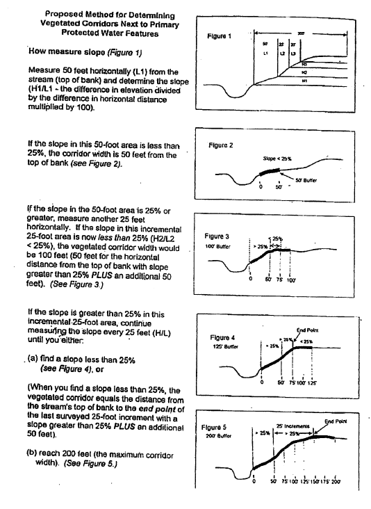
Advantages:
- Provides protection for most steep slopes, yet corridor widths can be varied to fit a number of different situations (corridor widths include 50 feet to 100 feet, 125 feet, 150 feet, 175 feet, and 200 feet)
- Provides flexibility.
Disadvantages:
- Does not protect slopes that rise steeply after a gradual “floodplain” area.
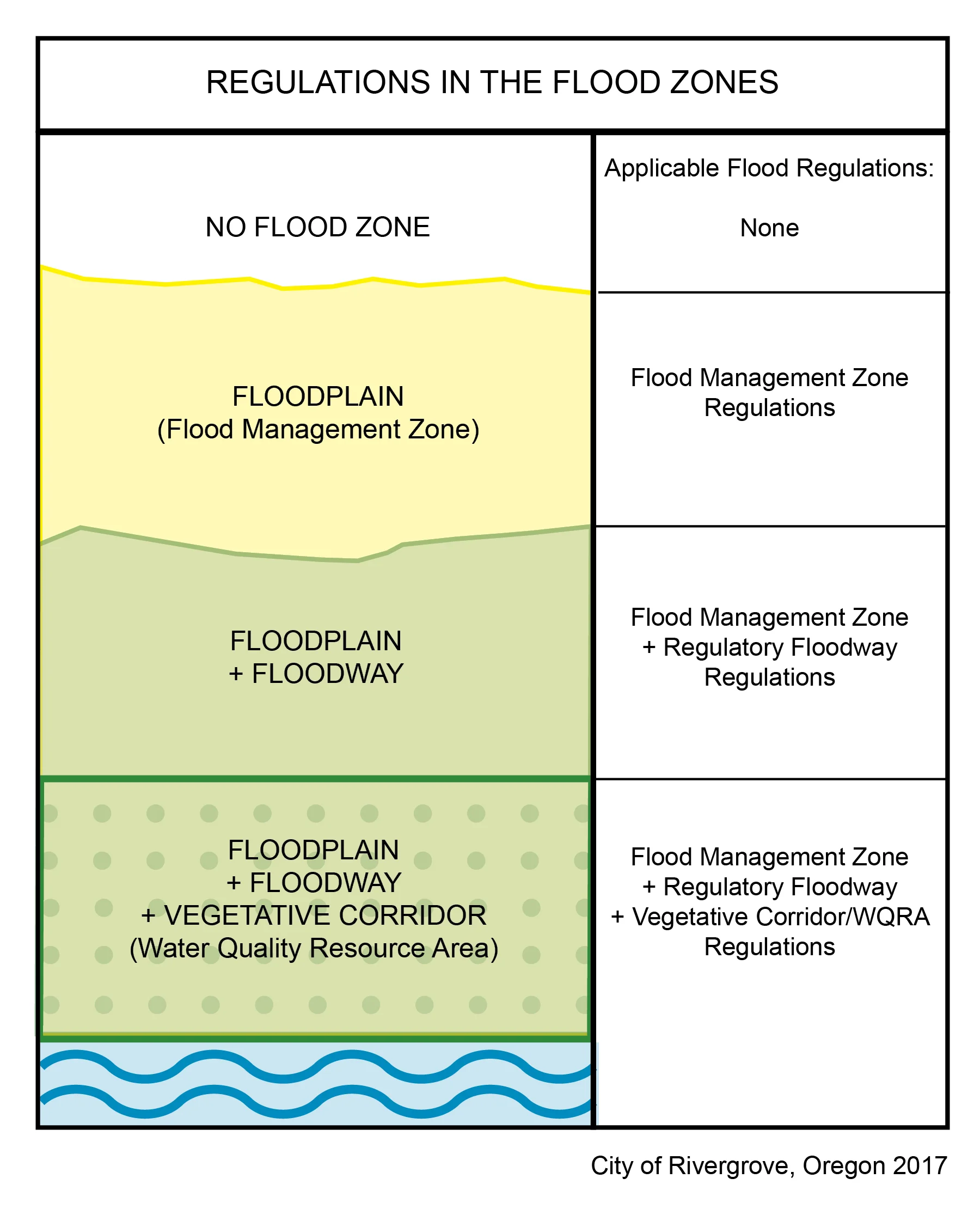
ORDINANCE NO. 71-2002
AN ORDINANCE AMENDING ATTACHMENT C TO ORDINANCE NO. 54-89, THE CITY OF RIVERGROVE’S LAND DEVELOPMENT ORDINANCE AND DECLARING AN EMERGENCY
Approved by the Planning Commission of the City of Rivergrove on August 5, 2002
Submitted to the Rivergrove City Council on August 12, 2002
Adopted by the Rivergrove City Council on 8/12/02
Signatures:
Signature
, Larry Barrett, Mayor
Date: 8-12-02
Signature
, Mike Collmeyer, City Recorder
Date: 8/12/02
ORDINANCE NO. 71-2002
AN ORDINANCE AMENDING ATTACHMENT C TO ORDINANCE NO. 54-89, THE CITY OF RIVERGROVE’S LAND DEVELOPMENT ORDINANCE AND DECLARING AN EMERGENCY
BEFORE THE CITY COUNCIL OF THE CITY OF RIVERGROVE, OREGON
WHEREAS, the City of Rivergrove has adopted a Comprehensive Plan and Land Development Ordinances to guide and control the future development within the City of Rivergrove; and
WHEREAS, the Comprehensive Plan and Land Development Ordinances are designed to ensure that the characteristics of future development are appropriate to the needs of the area and will be reasonably compatible with the livability and development of abutting property; and
WHEREAS, the Comprehensive Plan and Land Development Ordinances are designed to guide and control the future development within the City of Rivergrove in a manner that will preserve its residential character; and
WHEREAS, the residential character the City of Rivergrove wishes to preserve is that of a small, friendly, and close-knit community that embraces and supports all of its residents; and
WHEREAS, the exclusionary nature of a gated community does not promote or support the kind of community character the City of Rivergrove wishes to preserve; and
WHEREAS, the City of Rivergrove has adopted a Comprehensive Plan and Land Development Ordinances that include requirements for the provision of safe, efficient, convenient, and economical traffic and transportation systems; and
WHEREAS, gated communities and private streets generally do not promote or support safe and efficient street networks (traffic systems);
NOW THEREFORE, THE CITY COUNCIL OF THE CITY OF RIVERGROVE ORDAINS AS FOLLOWS: The Rivergrove Land Development Ordinance (Attachment C to Ordinance #54-89) is hereby amended as follows:
AMENDMENTS TO THE LAND DEVELOPMENT ORDINANCE
The following Sections are hereby added to and made part of ARTICLE 5 (DISTRICT AND ZONES) of Attachment C to Ordinance No. 54-89, The City of Rivergrove’s Land Development Ordinance (RLDO):
Section 5.130. Gates or Other Barriers. Gates or other barriers shall not be used to restrict access to residential developments from any public or private street or easement or right-of-way, except as specifically required or allowed by the City Council to address an operational or safety issue. For the purpose of this Section, residential development means a residential partition or subdivision or 2 or more dwelling units on a single lot or parcel or 2 or more residential lots or parcels.
Section 6.135. Public and Private Streets and Driveways. Public and private streets and driveways providing access to residential developments from any public or private street shall not be gated, except as specifically required or allowed by the City Council to address an operational or safety issue. For the purpose of this Section, residential development means a residential partition or subdivision or 2 or more dwelling units on a single lot or parcel or 2 or more residential lots or parcels.
EMERGENCY CLAUSE
Because this ordinance is necessary to allow the City to guide and control its future development in a manner which will preserve the City’s character; because this ordinance is necessary to allow the City to guide and control its future development in a manner which will ensure the provision of safe, convenient, and economical transportation systems, and because this ordinance is necessary to guide and control its future development both within and without the Flood Hazard District in a manner which protects the public health, safety and welfare of the citizens of Rivergrove; and in order to provide for a prompt transition in a reasonable time to the regulatory controls contained herein and to avoid a continuation of the current lack of regulatory controls in an area of such critical concern to the citizens of Rivergrove, an emergency is hereby declared to exist and this ordinance shall be in full force and effect from the time of passage by the City Council.
Adopted by the City Council, 08/12/02
ORDINANCE NO. 72-2002
AN ORDINANCE AMENDING ATTACHMENT C TO ORDINANCE NO. 54-89, THE CITY OF RIVERGROVE’S LAND DEVELOPMENT ORDINANCE
Approved by the Planning Commission of the City of Rivergrove on 10/7/02
Submitted to the Rivergrove City Council on 10/14/02
Adopted by the Rivergrove City Council on 10/14/02
Signature
, Larry Barrett, Mayor
Date: 10-14-02
Signature
, Mike Collmeyer, City Recorder
Date: 10/14/02
ORDINANCE NO. 72-2002
AN ORDINANCE AMENDING ATTACHMENT C TO ORDINANCE NO. 54-89, THE CITY OF RIVERGROVE’S LAND DEVELOPMENT ORDINANCE AS AMENDED BY ORDINANCE NO. 59-97A AND DECLARING AN EMERGENCY (strikethrough initialed by LB)
BEFORE THE CITY COUNCIL OF THE CITY OF RIVERGROVE, OREGON
WHEREAS, the City of Rivergrove has adopted a Comprehensive Plan and Land Development Ordinances to guide and control the future development within the City of Rivergrove; and
WHEREAS, the Comprehensive Plan and Land Development Ordinances are designed to ensure that the characteristics of future development are appropriate to the needs of the area and will be reasonably compatible with the livability and development of abutting property; and
WHEREAS, the Comprehensive Plan and Land Development Ordinances are designed to guide and control the future development within the City of Rivergrove in a manner that will preserve its residential character; and
WHEREAS, the City of Rivergrove wishes to provide an appropriate regulatory incentive for the abatement and correction of long standing conditions constituting the continuing use of land in violation of the City’s Land Development Ordinances;
NOW THEREFORE, THE CITY COUNCIL OF THE CITY OF RIVERGROVE ORDAINS AS FOLLOWS: The Rivergrove Land Development Ordinance (Attachment C to Ordinance #54-89 as amended by Ordinance No. 59-97A) is hereby amended as follows:
AMENDMENTS TO THE LAND DEVELOPMENT ORDINANCE
Amend Section 9.020. Penalties and Abatement to read as follows:
Section 9.020. Penalties and Abatement. This ordinance may be enforced in any manner now or hereafter authorized by law. Any person using land in violation of this ordinance
shallmay be punished, upon conviction, by a fine of not more than $100 for each day of violation where the offense is a continuing offense. For a noncontinuing offense, the fine shall be not more than $500. In addition, the City Council, the District Attorney, or a person whose interest in real property in the City of Rivergrove is or may be affected by the violation may, in addition to all other remedies provided by law, institute injunction, mandamus, abatement or other proceedings to prevent, temporarily or permanently enjoin or abate the unlawful use.
ORDINANCE NO. 73-2003A
AN ORDINANCE AMENDING ATTACHMENT C TO ORDINANCE NO. 54-89, THE CITY OF RIVERGROVE’S LAND DEVELOPMENT ORDINANCE AS AMENDED BY ORDINANCE NO. 59-97A
[Handwritten notation: “Conditional Use”]
Approved by the Planning Commission of the City of Rivergrove on 05/07/03
Submitted to the Rivergrove City Council on 5/12/03
Adopted by the Rivergrove City Council on 5/12/03
Signature
, Larry Barrett, Mayor
Date: 5/12/03
Signature
, Mike Collmeyer, City Recorder
Date: 5/12/03
ORDINANCE NO. 73-2003A
AN ORDINANCE AMENDING ATTACHMENT C TO ORDINANCE NO. 54-89, THE CITY OF RIVERGROVE’S LAND DEVELOPMENT ORDINANCE AS AMENDED BY ORDINANCE NO. 59-97A
BEFORE THE CITY COUNCIL OF THE CITY OF RIVERGROVE, OREGON
WHEREAS, the City of Rivergrove has adopted a Comprehensive Plan and Land Development Ordinances to guide and control the future development within the City of Rivergrove; and
WHEREAS, the Comprehensive Plan and Land Development Ordinances are designed to ensure that the characteristics of future development, to include conditional uses, are appropriate to the needs of the area and shall be reasonably compatible with the livability and development of abutting property; and
WHEREAS, the Comprehensive Plan and Land Development Ordinances are designed to guide and control the future development within the City of Rivergrove, to include conditional uses, in a manner that shall serve its residential character; and
WHEREAS, the annexation of Rivers Edge Athletic Club, which is operating under a Clackamas County conditional use permit, establishes a need for the City of Rivergrove to enact its own conditional use provisions;
NOW THEREFORE, THE CITY COUNCIL OF THE CITY OF RIVERGROVE ORDAINS AS FOLLOWS: The Rivergrove Land Development Ordinance (Attachment C to Ordinance #54-89 as amended by Ordinance No. 59-97A) is hereby amended as follows:
AMENDMENTS TO THE LAND DEVELOPMENT ORDINANCE
- The following Section is hereby amended: Amend Section 5.050 (g), as amended by Ordinance No. 59-97A, to read as follows:
- (g) Conditional uses, such as parks, playgrounds or community centers, churches, schools, golf courses, day or child care facilities, recreation uses, public and private clubs and use of similar nature as approved by the Commission and subject to Sections 6.300 through 6.340.
- (a) A description of the land (address, lot, block, tract, or similar description) on which the proposed development is to take place;
- (b) A list of the addresses of property within 200 feet of the affected property and mailing labels;
- (c) Narrative addressing how the application meets the relevant review criteria in 6.320 and 6.330 below;
- (d) Site plan drawn to scale and where relevant, illustrating existing and proposed:
- (e) If relevant, exterior lighting plan (which may be shown on the site plan) indicating location, size, height, typical design, material, color, method and strength of illumination.
- (f) If relevant, plans and elevations of structure(s) to scale indicating:
- (g) If relevant landscape plan drawn to scale showing:
- (h) Vicinity map showing the site in relation to local and collector streets; plus any other features in the nearby area;
- The following Sections are hereby added to and made part of ARTICLE 6 (PERMIT AND ISSUE DETERMINATIONS) of Attachment C to Ordinance No. 54-89, The City of Rivergrove’s Land Development Ordinance (RLDO):
Add after Section 6.236 the following:
Conditional Use
6.300. Conditional Use. The Planning Commission may allow a conditional use, after a hearing conducted pursuant to the Type III land use procedure in the Rivergrove Land Development Ordinance provided the applicant complies with the relevant Application Requirements of this section and demonstrates that the proposed use satisfies the applicable conditions set forth in this ordinance and the Rivergrove Land Development Ordinance. For the purposes of Section 6.300 through 6.340, the Planning Commission has the responsibility and authority to determine the relevance of requirements and criteria and the applicability of conditions.
6.310. Application Requirements. An application for Conditional Use will be on forms provided by the City Recorder and will include the following where applicable:
- (1) Relationship of the site to adjoining properties, streets, alleys, structures, public utilities, and drainageways;
- (2) Lot line dimensions;
- (3) Location of structures;
- (4) Vehicle and pedestrian access points and accessways;
- (5) General location of vegetated areas;
- (6) Utility service areas;
- (7) Fences and walls;
- (8) Parking spaces, maneuvering, loading, and refuse areas;
- (9) Direction of traffic flow on the property;
- (10) Drainage controls;
- (11) Proposed modifications to existing grades.
- (1) Heights of structure;
- (2) Entrances and exits of proposed structures;
- (3) Architectural drawings or sketches, including floor plans, in sufficient detail to permit computation of set back requirements;
- (4) Building materials to be used;
- (5) Specifications as to type, color, and texture of exterior surfaces of proposed structures.
- (1) Location of existing trees and vegetation proposed to be removed or retained on the site;
- (2) Location and design of landscaped areas;
- (3) Proposed varieties and sizes of trees and plant materials;
- (4) Other pertinent landscape features, and irrigation systems required to maintain plant materials.
(i) Any additional information that may be required by the Planning Commission to properly evaluate the proposed conditional use, if the need for such information is justified on the basis of special and/or unforeseen circumstances.
- (j) The Planning Commission may waive any of the requirements above where determined that the information required is unnecessary to properly evaluate the proposal. The applicant will provide a number of plans as required by the City Recorder.
- (a) The characteristics of the site are suitable for the proposed use considering size, shape, location, topography, existence of improvements and natural features;
- (b) The site and proposed development are timely, considering the adequacy of transportation systems, public facilities and services existing or planned for the area affected by the use;
- (c) The proposed use will not affect the surrounding area in a manner which adversely limits, impairs or precludes the use of surrounding properties;
- (a) Permits for conditional uses stipulate restrictions or conditions which may include, but are not limited to, a definite time limit to meet such conditions, provisions for a front, side or rear yard greater than the minimum set back standards, suitable landscaping, off-street parking and any other reasonable restriction, condition or safeguard that would uphold the spirit and intent of the Rivergrove Land Development Ordinance, and mitigate any adverse effect upon the neighborhood properties as set forth in the findings of the Planning Commission.
- (b) In the case of a use existing prior to the effective date of the ordinance codified in this title and classified in this title as a conditional use, any change of use, expansion of lot area or expansion of structure conform with the requirements for conditional use.
- (c) A conditional use approval expire if it is not implemented within 2 years from the date of the final written decision unless a lesser time period is specified as a condition of approval or a time extension is approved pursuant to RLDO 6.340(d). If the City’s final written decision is appealed, the approval period commences on the date of the final appellate decision. A conditional use approval is implemented when all necessary permits for development have been secured and are maintained. Approval of public roads, public schools and public parks do not expire unless an expiration date is specified as a condition of approval.
- (d) A 1-year time extension may be granted once as a Type I decision by the Planning Commission pursuant to RLDO 4.090 and subject to the following provisions:
- (e) Any violation of the terms, conditions or restrictions of a conditional use permit can result in revocation of the conditional use permit.
6.320. Review Criteria. Applications for a conditional use will be reviewed to assure consistency with the purposes of this ordinance, the Rivergrove Land Development Ordinance, policies of the Comprehensive Plan, and any other applicable policies and standards adopted by the City Council. In addition, the Planning Commission will consider and weigh with equal priority the following compatibility factors that are relevant to the proposal:
- (a) Basic site design (organization of uses on the site);
- (b) Noise attenuation;
- (c) Noxious odors;
- (d) Lighting;
- (e) Signage;
- (f) Landscaping for buffering and screening;
- (g) Traffic;
- (h) Effects on off-street parking;
- (i) Effects on air and water quality.
6.330. Additional Criteria. The Planning Commission may allow a conditional use, provided that the applicant provides evidence substantiating that all the requirements of the ordinance relative to the proposed use are satisfied, and demonstrates that the proposed use also satisfies the following criteria:
6.340. Conditions
- (1) A time extension be requested in writing, on forms provided by the City Recorder, prior to the expiration of the approval; and
- (2) The applicant demonstrates that:
- (a) The conditional use is consistent with the provisions of this ordinance in effect on the date a complete application for a time extension is submitted; and
- (b) There is a reasonable expectancy that the necessary development permits will be secured within the 1-year extension period.
ORDINANCE NO. 74-2004
AN ORDINANCE AMENDING ATTACHMENT C TO ORDINANCE NO. 54-89, THE CITY OF RIVERGROVE’S LAND DEVELOPMENT ORDINANCE
Approved by the Planning Commission of the City of Rivergrove on February 2, 2004.
Submitted to the Rivergrove City Council on March 8, 2004.
Re-Submitted to the Rivergrove City Council on May 10, 2004.
Adopted by the Rivergrove City Council on May 10, 2004.
[Unsigned], Larry Barrett, Mayor
Date:
[Unsigned], Mike Collmeyer, City Recorder
Date:
ORDINANCE NO. 74-2004
AN ORDINANCE AMENDING ATTACHMENT C TO ORDINANCE NO. 54-89, THE CITY OF RIVERGROVE’S LAND DEVELOPMENT ORDINANCE
BEFORE THE CITY COUNCIL OF THE CITY OF RIVERGROVE, OREGON
WHEREAS, the City of Rivergrove has adopted a Comprehensive Plan and Land Development Ordinances to guide and control the future development within the City of Rivergrove; and
WHEREAS, the Comprehensive Plan and Land Development Ordinances are designed to ensure that the characteristics of future development are appropriate to the needs of the area and will be reasonably compatible with the livability and development of abutting property; and
WHEREAS, the Comprehensive Plan and Land Development Ordinances are designed to guide and control the future development within the City of Rivergrove in a manner that will preserve the residential character of the City and will protect and preserve as much as possible the natural conditions (especially the native vegetation) of the area; and
WHEREAS, the Comprehensive Plan requires that wildlife and plant habitat considerations be integrated into the land use decision-making process; and
WHEREAS, the Comprehensive Plan encourages, especially in Environmentally Sensitive Areas, the preservation of existing wildlife habitat and major stands of trees to the maximum extent practical;
NOW THEREFORE, THE CITY COUNCIL OF THE CITY OF RIVERGROVE ORDAINS AS FOLLOWS: The Rivergrove Land Development Ordinance (Attachment C to Ordinance #54-89) is hereby amended as follows:
AMENDMENTS TO THE LAND DEVELOPMENT ORDINANCE
Section 5.100. Tree Cutting
Section 5.100. Tree Cutting is amended to read as follows:
Section 5.100. Tree Cutting
(a) DEFINITIONS
“Tree”: Any standing woody plant having a trunk 11.5 inch diameter (36“ inch circumference) measured 4.5 feet from the ground (DBH diameter-breast-height). “Tree” does not include any plant on the Nuisance Plant List.
“Cutting”: Felling or removal or any procedure that has the natural result of causing the death or substantial destruction of a tree; cutting does not include trimming, limbing, pruning or topping within the bounds of accepted arboricultural practices. Cutting includes damage inflicted upon the root system of the tree.
(b) APPLICATION FOR PERMIT
A permit is required for each tree cut within the City of Rivergrove. Application is to be made and permit to be obtained from the City before the tree is cut. For permits issued under Emergency conditions, see part (c) below.
Permits or emergency permits for the first three trees not located in a Water Quality Resource Area¹ cut on a single lot or parcel in any twelve, consecutive calendar months: Approval will be granted by the City without a hearing. Such permits will be granted promptly upon submission of a written application. There will be no fee charged for this type of permit.
Permits for cutting trees beyond the first three trees cut on a single lot or parcel in any twelve, consecutive calendar months and for trees located in a Water Quality Resource Area: Written application must be made to the City for approval by the Planning Commission at one of its meetings. The first three trees cut on a single lot or parcel in any twelve, consecutive calendar months include any trees cut under emergency conditions in accordance with subsection (c) below.
The application shall contain the number, size, species, and location of the trees to be cut, the time and method of cutting or removal. In addition, the applicant shall furnish other information as may be required by the City.
If the tree cutting permit is approved, a fee of $20 per tree (plus costs incurred by the City for all administrative, legal, engineering and planning requirements associated with the application) will be assessed starting with the fourth tree for that twelve month period. The application will not require review by staff unless directed by the Planning Commission.
Notwithstanding subsection 5) above, a single fee of $20.00 (plus costs incurred) will be assessed for a permit application that deals solely with dead, dangerous, and dying trees.
¹ For a determination of Water Quality Resource Areas within the City of Rivergrove, see Rivergrove Land Development Ordinance # 70-2001.
(c) EMERGENCIES
In emergency conditions that require the immediate cutting or removal of trees to avoid danger or hazard to persons or property, an emergency permit may be issued by the Mayor, the President of the City Council or the Chairman of the Planning Commission, without formal application or payment of a fee. If they are unavailable, it shall be lawful to cut trees without a permit to the extent necessary to avoid an immediate danger or hazard. If a tree is cut under the provisions of this section, without an application having been filed, the property owner shall report the action taken to one of the aforementioned people within 7 days after such removal and provide information and evidence as may be reasonably required to explain and justify the action. If the evidence and information presented by the property owner does not justify the emergency tree cutting standards set forth, the application shall be denied and the property owner shall be subject to the penalties set forth in the Rivergrove Land Development Ordinance (RLDO).
(d) CRITERIA FOR ISSUANCE OF PERMITS
A tree cutting permit may be issued by the Planning Commission as requested in the application; may be issued in part and denied in part, or may be issued subject to compliance by the applicant with reasonable conditions to be imposed in order to promote the purpose of this Ordinance. The application does not require review by staff unless directed by the Planning Commission. A permit shall state the period of time for which it is valid. A permit issued for the reason that an improvement is to be constructed upon the premises shall contain a provision that a permit is not valid until a building permit or development permit has been issued for the construction of the improvement. The burden is on the applicant to show that granting of a permit would be consistent with the stated purposes of the Rivergrove Land Development Ordinance (RLDO). The following criteria shall be considered:
The condition of the trees with respect to dead, dying, dangerous, proximity to existing or proposed structures or development, and interference with utility services or traffic safety. For the purposes of Section 5.100:
a. “Dead” means the tree is lifeless.
b. “Dying” means the tree is in an advanced state of decline because it is diseased, infested by insects or rotting and cannot be saved by reasonable treatment or pruning, or must be removed to prevent spread of the infestation or disease to other trees.
c. “Dangerous” means the condition or location of the tree presents a clear public safety hazard or a foreseeable danger of property damage to an existing structure and such hazard or danger cannot reasonably be alleviated by treatment or pruning.
The planning commission may require the retention of dead or dying trees located in wetlands, natural areas, stream corridors, parks or open space areas, in order to provide for wildlife habit and natural processes, unless the tree presents a potential hazard to persons or property or conflicts with development.
The necessity to remove trees in order to construct proposed improvements, or to otherwise utilize the applicant’s property in a reasonable manner.
The topography of the land and the effect of tree removal on erosion, soil retention, stability of earth, flow of surface waters, protection of nearby trees, windbreaks, and a desirable balance between shade and open space.
The number of trees existing in the neighborhood, the character and property uses in the neighborhood, and the effect of tree removal upon neighborhood characteristics, beauty and property values.
The planning commission may require an adequate mitigation plan be submitted as a condition of approval for the permit, including requiring the submission of a drainage plan if appropriate.
(e) EVIDENCE OF VIOLATION
If a tree is removed without a tree cutting permit, a violation may be determined by measuring the stump. A stump measured at the ground that is 44“ or more in circumference shall be considered prima facie evidence of a violation.
Removal of the stump of a tree cut without a tree cutting permit prior to the determination is a violation.
Proof of violation shall be deemed prima facie evidence that such violation is that of the owner of the property upon which the violation was committed. Prosecution of or failure to prosecute the owner shall not be deemed to relieve any other responsible individual property owner, legal entity, or collective parties.
(f) APPEAL
A decision made by the Planning Commission may be appealed to the City Council. A Notice of Appeal must be submitted in writing within 10 days after the denial, shall briefly state the facts and grounds of appeal and shall be signed by the appellant. Following receipt of the Notice of Appeal the matter shall be set for hearing no later than 45 days from the date of receipt. The appellant shall be notified of the hearing date.
(g) PENALTIES
Cutting a tree in violation of the Ordinance, breach of a term or conditions of a permit granted under this Ordinance, or violation of any other provision of this Ordinance is an offense punishable by fine not to exceed $1,500.00. The unlawful cutting of each individual tree is a separate offense.
The City retains the authority to require the applicant to replace any illegally removed trees pursuant to a plan, and meet any conditions as set forth by the Planning Commission. No future permits or approvals for any use of the subject property shall be granted without compliance with the plan.
The property owner has the burden to prove that the criteria for granting a permit are satisfied or that cutting is allowed without a permit.
ORDINANCE NO. 76-2008
AN ORDINANCE AMENDING THE RIVERGROVE LAND DEVELOPMENT ORDINANCE, AND ORDINANCE NO. 52 AND ORDINANCE NO. 70-2001 AND DECLARING AN EMERGENCY
Submitted to the Rivergrove City Council on 6-9-08
Adopted by the Rivergrove City Council on 6-9-08
Are
Signature
, Hafez Darae, Mayor
Date: 6-9-08
Signature
, Sheri Richards, City Recorder
Date: 6-9-08
ORDINANCE NO. 76-2008
AN ORDINANCE AMENDING THE RIVERGROVE LAND DEVELOPMENT ORDINANCE, AND ORDINANCE NO. 52 AND ORDINANCE NO. 70-2001 AND DECLARING AN EMERGENCY
WHEREAS, The legislature of the state of Oregon has delegated the responsibility to local government units to adopt regulations designed to promote public health, safety and general welfare, and
WHEREAS, The risk of flooding, including the risk to human life and property, and the maintenance of the functions and values and flood plains by allowing for the storage and conveyance of stream flows through their natural systems are vitally important to the public health, safety and general welfare, and
WHEREAS, The City has adopted a Flood Damage Prevention Ordinance, Ordinance No. 52, with amendments as set in Ordinance No. 62-98, and
WHEREAS, The City has adopted Ordinance No. 70-2001 to comply with the requirements of Title 3 of Metro’s Urban Growth Management Functional Plan, and
WHEREAS, the Federal Emergency Management Agency (“FEMA”) has recently updated the Flood Insurance Study (FIS) and Flood Insurance Rate Map (“FIRM”) for the areas including the City that changes the floodplain and floodway to more accurately depict those areas and to account for changes, and
WHEREAS, It is in the best interest of the City to adopt the new FEMA Flood Insurance Study and Flood Insurance Rate Map to protect the public health, safety and general welfare, and
WHEREAS, an emergency exists that requires the immediate effectiveness of this ordinance is required to protect citizens of Rivergrove,
NOW THEREFORE; The City of Rivergrove ordains as follows:
Section 1: Section 3.2 of Ordinance No. 52 is amended to read as follows:
3.2 BASIS FOR ESTABLISHING THE AREAS OF SPECIAL FLOOD HAZARD
The area of special flood hazard identified by the Federal Insurance Administration in a scientific and engineering report entitled “Flood Insurance Study Clackamas County, Oregon and Incorporated Areas Volume 1 of 3 effective June 17, 2008 FIS Number 41005CV001A,” with accompanying Flood Insurance Maps is hereby adopted by reference and declared to be a part of this ordinance. The Flood Insurance Study is on file at the City Recorder’s office.
Section 2: Attachment C to Ordinance No. 54-89 (the Rivergrove Land Development Ordinance) is amended to read as follows:
Section 5.020 Flood Hazard District.
All land development within the 100 year flood boundary as identified in the Flood Insurance Rate Map (FIRM) Panel 0013D Map Number 41005C0013D effective date June 17, 2008 shall be within the Flood Hazard District (FHD) and shall be subject to special requirements in addition to the criteria and standards of this ordinance. Land subject to flood hazard is generally indicated on the floodplain map found in the Flood Insurance Study and consists of those areas of the City where hydrological studies have been prepared by the Federal Emergency Management Agency. The FIRM shall be available to public inspection by contacting the City Recorder at 503 624-8498 during regular business hours. All development within the 100 year flood boundary shall follow the provisions of the Flood Damage Prevention Ordinance of the City of Rivergrove (Ord. #52 and Ord. #70-2001) in addition to the provisions of this ordinance.
Section 3: Section XIV of Ordinance No. 70-2001 is amended as follows:
Section XIV Definitions
Flood Management Areas. All lands contained within the 100 year floodplain and floodway as shown on the Federal Emergency Management Agency Flood Insurance Rate Map Panel 0013D effective date June 17, 2008
Section 4: Emergency Declared.
Because the immediate effectiveness of this ordinance is needed to protect the public health, safety and welfare, an emergency is declared and, in accordance with Section 36 of the Rivergrove City Charter, this ordinance shall be effective immediately upon passage by the Rivergrove City Council.
ORDINANCE 80-2011
AN ORDINANCE OF THE CITY OF RIVERGROVE ADOPTING HOURS OF OPERATION FOR THE RIVERGROVE CITY PARK AND RIVER ACCESS
WHEREAS, the City is the owner and manager of the Lloyd Minor Park (the “Park”) with access to the Tualatin River; and
WHEREAS, the City recognizes that use of the Park and River Access can have impacts on neighbors and City resources; and
WHEREAS, the City desires to adopt hours of operation for the Park and River Access to protect the neighbors of the Park and control access to the Tualatin River,
NOW, THEREFORE, THE CITY OF RIVERGROVE ORDAINS AS FOLLOWS:
Section 1.
The City hereby adopts the following hours of operation for the Lloyd Minor City Park and River Access:
A. From November through April, the park and river access shall be open from 8:00 am to 8:00 pm.
B. From May through October, the park and river access shall be open from 8:00 am to 9:00 pm.
Section 2. Emergency Clause
Because this ordinance is necessary to address current use of the Park and River Access, an emergency is hereby declared to exist and this ordinance shall be in full force and effect from the time of passage by the City Council.
Adopted this 14th day of July, 2011
Vote: 4 Yeas, 0 Nays
Heather Kibbey, Mayor
Sheri Richards, City Recorder
CITY OF RIVERGROVE MUNICIPAL SIGN ORDINANCE
TABLE OF CONTENTS
Section 1. Title.
Section 2. Purpose.
Section 3. Definitions.
Section 4. General Requirements.
Section 5. Exempt Signs.
Section 6. Allowed Signs.
Section 7. Temporary Signs.
Section 8. Prohibited Signs.
Section 9. Nonconforming Signs.
Section 10. Construction and Maintenance Standards.
Section 11. Removal of Signs.
Section 12. Enforcement of Sign Code by City Manager.
Section 13. Penalties.
Section 1. Title.
This ordinance shall be known as the “Rivergrove Sign Ordinance.”
Section 2. Purpose.
The purpose of this ordinance is to protect the health, safety, property and welfare of the public, to provide a neat, clean, orderly and attractive appearance of the community, to improve the effectiveness of signs, to provide for safe construction, location, erection and maintenance of signs, to prevent proliferation of signs and sign clutter, to minimize adverse visual safety factors to travelers on public highways and on private areas open to public travel, and to achieve this purpose consistent with state and federal constitutional limits on the regulation of speech. To achieve this purpose it is necessary to regulate the design, quality of materials, construction, location, electrification, illumination, and maintenance of signs that are visible from public property, public rights-of-way and private areas open to public travel.
Section 3. Definitions.
For the purposes of this ordinance, unless the context indicates otherwise: words in the present tense include the future; the singular number includes the plural and the plural number includes the singular; undefined words have their ordinary accepted meaning; and, the following words and phrases mean:
Banner—A sign made of fabric or other non-rigid material with no enclosing framework.
Bench sign—A sign on an outdoor bench.
Billboard—A sign on which any sign face exceeds two hundred square feet in area.
Flag—A piece of fabric of distinctive design that is displayed hanging free from a staff, halyard or building to which it is attached. A flag is often used to display the symbol of the United States, a nation, state, local government, business, organization or a person.
Freestanding sign—A sign that is not attached to a building and is erected on a structure connected to the ground. A freestanding sign does not include a portable sign. No part of a freestanding sign shall be erected or maintained within three feet of a street front property line, or within five feet of a side lot line and a freestanding sign shall not project or extend into a right-of-way or any vision clearance area. Only one freestanding sign is allowed for each street frontage.
Handheld sign—A hand carried sign of four square feet or less, four linear feet in any direction, worn or carried by a person when being displayed.
Height—The vertical distance measured from grade to the highest attached component of a sign including the supporting structure.
Name plate—A permanent wall sign located on the front façade of a residential structure.
Nonconforming sign—A sign that was lawful when it was constructed but does not meet the requirements of this ordinance.
Pennant—A sign device made from a strip of flexible material intended to wave in the wind.
Portable sign—A sign that is not permanently affixed to a building, structure, or the ground and designed to be moved from place to place.
Public right-of-way—A travel area open for public use and or under control of a public agency, including but not limited, to highways, private streets, public streets, bike paths, alleys and sidewalks.
Public sign—A sign that was constructed or placed within or proximate to the public right-of-way by or with the approval of the governmental agency having authority over, control of or ownership of the right-of-way or a sign that was constructed or placed by a public utility on or adjacent to a pole, pipe, or distribution facility of the utility and within or proximate to the public right-of-way.
Repair—Mending or replacing broken or worn parts with comparable materials.
Roof sign—A sign erected upon, against, or over the roof of any building or structure.
Seasonal decorations—Every type of decoration displayed during and around a federally recognized holiday or on a seasonal basis, whether illuminated or not, and whether attached to utility poles, buildings or any other structure.
Sign—Any writing, video projection, pictorial representation, illustration, decoration (including any material used to differentiate sign copy from its background), emblem, symbol, design, trademark, banner, flag, pennant, captive balloon, streamer, spinner, ribbon, sculpture, statue, or any other figure or character that:
- Is a structure or any part thereof (including the roof or wall of a building); or
- Is written, printed, projected, painted, constructed, transmitted or otherwise placed or displayed upon or designed into a structure or an outdoor screen or monitor, or a board, plate, canopy, awning, marquee, or a vehicle, or upon any material object or device whatsoever; and
- By reason of its form, color, wording, symbol, design, or illumination, attracts or is designed to attract attention and communicate a message. Graphics, murals and art work that do not communicate informational messages, apart from any aesthetic or artistic message, are not signs. It is a disputable presumption that a graphic, mural or art work that depicts or relates to the use of a site or structure on which it is displayed, is intended to communicate an informational message about the site or structure.
Sign copy—The message or image conveyed by a sign.
Sign face—The sum of the surfaces of a sign face as seen from one plane or elevation included within the outer dimensions of the sign board, frame or cabinet.
Sign area—The area of the sign measured within lines drawn between the outermost points of a sign, but excluding essential sign structure, foundations, or supports.
Sign height—The average level of the grade below the sign to the topmost point of the sign including the supporting sign structure, foundations, and supports.
Site—The area, tract, parcel, or lot of land owned by or under the lawful control of an owner. Abutting platted lots under the same ownership shall be considered one site.
Street frontage—The length or width of a site, measured along a line separating the site from a street or public right-of-way.
Structure—That which is built or constructed. An edifice or building of any kind or any piece of work artificially built up or composed of parts joined together in some definite manner and which requires location on the ground or which is attached to something having a location on the ground.
Supporting structure—A structure specifically intended for supporting or containing a sign.
Temporary Signs – See Section 7 of this ordinance.
Vehicle sign—A non-illuminated sign permanently or temporarily placed on or attached to the exterior of a motor vehicle, trailer railroad car, or light rail car that is used in the regular course of business for purposes other than the display of signs.
Video sign.—A sign providing information in both a horizontal and vertical format (as opposed to linear), through use of pixel, sub-pixel or other technology having the capacity to create continuously changing sign copy.
Vision clearance area—A triangular area on a lot at the intersection of two streets or a street and a railroad, alley, or driveway, two sides of which are lot lines measured from the corner intersection of the lot lines. The third side of the triangle is a line across the corner of the lot joining the ends of the other two sides. Where the lot lines at intersections have rounded corners, the lot lines will be extended in a straight line to a point of intersection.
Section 4. General Requirements.
A. Except as provided in this ordinance, no person shall erect, construct, enlarge, alter, repair, move, improve, remove, convert, demolish, equip, use or maintain any sign, or cause or permit the same to be done, contrary to or in violation of any of the provisions of this ordinance.
B. No owner shall erect or construct a sign on a site that contains unlawful signs.
C. This ordinance shall not be construed to permit the erection or maintenance of any sign at any place or in any manner unlawful under any other city code provision or other applicable law. In any case where a part of this ordinance conflicts with a provision of any zoning, building, fire, safety or health ordinance or code, the provision which establishes a stricter standard for the protection of the public health and safety shall prevail.
D. This ordinance is not intended to, and does not restrict speech on the basis of its content, viewpoint or message. Any classification of signs in this ordinance that permits speech by reason of the type of sign, identity of the sign user or otherwise, shall permit any type of speech on the sign. No part of this ordinance shall be construed to favor commercial speech over non-commercial speech. To the extent any provision of this ordinance is ambiguous, the term shall be interpreted to not regulate on the basis of speech content, and the interpretation resulting in the least restriction on the content of the sign message shall prevail.
E. If any section, subsection, paragraph, sentence, clause or phrase of this ordinance is declared invalid for any reason by a court having jurisdiction under state or federal law, the remaining portions of this ordinance shall remain in full force and effect.
Section 5. Exempt Signs.
Except for signs prohibited by this ordinance, the following signs are exempt from the provisions of this ordinance:
A. All signs that are placed inside a structure or building, and that are either not visible through windows or building openings, or are not intended to be visible from outside of the structure or building.
B. Public Signs.
C. Signs required by law, administrative order or judicial order and erected by public employees performing official duties.
Section 6. Allowed Signs.
The following signs are allowed in all areas of the City and do not require any permit. All signs listed in this section are subject to all other applicable requirements of the Rivergrove Sign Code.
A. One indirectly illuminated or non-illuminated sign not exceeding one and one-half square feet in area placed on any non-multifamily residential lot. This type of sign is typically used as a name plate.
B. Flags, provided that no more than 2 flags are displayed upon a lot under two acres in size and no more than 5 flags are displayed upon a lot two or more acres in size. Flag pole height may not exceed the maximum height limitation contained in the Rivergrove Land Development Ordinance.
C. Vehicle signs.
D. Signs displayed upon a bus or light rail vehicle owned by a public transit district.
E. Seasonal decorations on private property. Seasonal decorations may include flashing or illuminated elements.
F. Handheld signs.
G. Signs up to four square feet, four linear feet in any direction and four feet maximum height, constructed or placed within a parking lot. These signs are typically used to direct traffic and parking.
H. Any public notice or warning required by federal, state or local law, regulation or ordinance, or a sign within the public right-of-way that is erected by a governmental agency, utility or contractor doing authorized work within the right-of-way.
I. A sign that does not exceed four square feet, four linear feet in any direction and four feet maximum height, is not erected in a vision clearance area, and is erected on property where there is a danger to the public or to which public access is prohibited.
J. Signs incorporated into vending machines or gasoline pumps.
K. Temporary signs as allowed under Section 7 of this ordinance.
Section 7. Temporary Signs.
A. Temporary signs may be erected and maintained in the city only in compliance with the regulations in this ordinance, and with the following specific provisions:
-
No temporary sign shall be internally illuminated or be illuminated by an external light source primarily intended for the illumination of the temporary sign.
-
Temporary signs shall be kept neat, clean and in good repair. Signs that are faded, torn, damaged or otherwise unsightly or in a state of disrepair shall be immediately repaired or removed. A temporary sign shall be attached to the site or constructed in a manner that both prevents the sign from being easily moved or blown from its location and allows for the easy removal of the sign.
-
Except as provided in this code, temporary signs shall not be attached to trees, shrubbery, utility poles or traffic control signs or devices. Temporary signs shall not obscure or obstruct signs on adjacent premises.
-
No temporary sign shall be erected or maintained that, by reason of its size, location or construction constitutes a hazard to the public.
B. The following temporary signs shall be allowed on a lot without issuance of a permit and shall not affect the amount or type of signage otherwise allowed by this ordinance. This signage shall not be restricted by content, but is usually and customarily used to advertise real estate sales, political or ideological positions, garage sales, home construction or remodeling and similar activities. Signage shall be allowed for each lot as follows:
-
Freestanding signs not exceeding four square feet, four linear feet in any direction and four feet maximum height, during the period from 120 days before a public election or the time the election is called, whichever is earlier, to five days after the public election.
-
One temporary sign not exceeding four square feet, four linear feet in any direction and four feet maximum height, which is erected for a maximum of eight days in any calendar month and is removed by sunset on any day it is erected.
-
A freestanding sign not exceeding four square feet, four linear feet in any direction and four feet maximum height, during the time of sale, lease or rental of the property provided that the sign is removed within 15 days of the sale, lease or rental of the property. The sign may remain in place for no more than 60 days in any 90 day period.
D. No temporary signs or banners shall be allowed in the public right of way or on public property, except for those listed in this subsection.
-
The following temporary signs shall be permitted in the right-of-way and shall not affect the amount or type of signage otherwise allowed by this ordinance. No temporary sign in the right-of-way shall interrupt the normal flow of vehicle, pedestrian or bicycle traffic and shall provide a minimum of five feet of clear passage for pedestrians on a sidewalk where a sidewalk exists. No temporary sign shall extend into a vision clearance area. Temporary signs allowed in the right-of-way shall include:
a. Signs owned or erected by a governmental entity.
b. Portable signs limited to a maximum of four square feet, four linear feet in any direction and four feet maximum height, displayed only on weekends and holidays, placed at street intersections in relative close proximity to a property for sale or lease during the time of that display. One single sign for each property or development shall be permitted at each intersection and shall be positioned as to be no closer than two feet from areas subject to vehicular travel.
c. Bench signs located at mass transit stops so long as the bench sign copy does not exceed 15 square feet and the bench sign is approved by the owner.
d. Signs attached to mass transit shelters that have been approved by the mass transit agency and the owner.
Section 8. Prohibited Signs.
The following signs are unlawful and are nuisances:
A. Billboards.
B. Video signs.
C. Any sign constructed, maintained or altered in a manner not in compliance with this ordinance.
D. Any sign constructed in such a manner or at such a location that it will obstruct access to any fire escape or other means of ingress or egress from a building or an exit corridor, exit hallway or exit doorway. No sign or supporting structure shall cover, wholly or partially, any window or doorway in any manner that it will substantially limit access to the building in case of fire.
E. Any sign located in a manner that could impede traffic on any street, alley, sidewalk, bikeway or other pedestrian or vehicular travel way.
F. Any sign equipped with moving, rotating or otherwise animated parts.
G. Any sign that is wholly or partially illuminated by a flashing light, lights, lamps, bulbs, or tubes, except as specifically allowed elsewhere in this sign ordinance. Rotary beacon lights, zip lights, strobe lights, or similar devices shall not be erected or maintained, or attached to or incorporated in any sign.
H. Roof signs.
I. Any sign attached to a tree or a plant, a fence or a utility pole, except as otherwise allowed by this ordinance.
J. Any sign within or over any public right of way, or located on private property less than two feet from any area subject to vehicular travel, except for:
-
Public signs.
-
Temporary signs specifically allowed within the public right of way under section 7 of this ordinance.
K. Temporary signs, including banners, pennants, wind signs, and flags, except as authorized by sections 6 or 7 of this ordinance.
Section 9. Nonconforming Signs.
A. Nonconforming signs may continue to exist, subject to the following provisions:
-
No additions or enlargements may be made to a non-conforming sign except those additions or enlargements that are required by law.
-
A sign that is moved, replaced, or structurally altered shall be brought into conformance with this ordinance, except that:
a. Nonconforming signs may be repaired and maintained and may have the sign copy changed. A sign may be removed from its sign structure for repair or maintenance if a permit is obtained under this ordinance.
b. Nonconforming signs may be structurally altered when the alteration is necessary for structural safety.
c. Nonconforming signs may be reconstructed if required to be moved for construction or repair of public works or public utilities and the sign reconstruction is completed within 90 days after the completion of the public works or public utility construction or repair.
-
A nonconforming sign that is damaged shall not be repaired if the estimated expense to repair the sign exceeds 50 percent of the replacement cost of the sign as of the day before the sign was damaged. A damaged nonconforming sign that cannot be repaired shall be removed within 90 days of the date the sign was damaged. As used herein, “nonconforming sign” includes the sign structure, foundation and supports.
-
Whenever a nonconforming sign is damaged and the estimated cost to repair the sign is 50 percent or less of its replacement value as of the day before the sign was damaged, it may be repaired and restored to the condition it was in before it was damaged and may continue to be used as a nonconforming sign, provided that such repairs and restoration are started within 90 days of the date the sign was damaged and are diligently pursued thereafter.
-
No nonconforming sign shall be permitted to remain unless properly repaired and maintained as provided in this ordinance. A sign maintained in violation of this provision shall be removed as provided in section 11 of this ordinance. Any nonconforming sign that is determined by the building official to be an unsafe sign shall be removed as provided in this ordinance.
B. Nothing in this section shall be deemed to prevent the maintenance of any sign, or regular manual changes of sign copy on a sign.
Section 10. Construction and Maintenance Standards.
A. All permanent signs shall be constructed and erected in accordance with the requirements of the International Building Code, as adopted by the State of Oregon.
B. Building and electrical permits shall be the responsibility of the applicant. Prior to obtaining building and electrical permits, the applicant shall obtain a sign permit or demonstrate an exception from the permit requirements of this ordinance.
C. All signs, together with all of their supports, braces, guys, and anchors shall be kept in good repair and be maintained in a safe condition. All signs and the site upon which they are located shall be maintained in a neat, clean, and attractive condition. Signs shall be kept free from excessive rust, corrosion, peeling paint or other surface deterioration. The display surfaces of all signs shall be kept neatly painted or posted.
D. No sign shall be erected or maintained in such a manner that any portion of its surface or supports will interfere in any way with the free use of any fire escape, exit, or standpipe. No signs shall be erected or maintained so as to obstruct any building opening to such an extent that light or ventilation is reduced below minimums required by any applicable law or provisions of this code.
Section 11. Removal of Signs.
A. The City Manager may remove or may order the removal of any sign erected or maintained in violation of the provisions of this ordinance or other applicable provisions of this code. Signs installed in violation of any prior sign code or applicable laws and regulations, and which are in violation of this ordinance, shall be removed, replaced or altered in order to conform to the requirements of this ordinance. An order to remove a sign shall be in writing and mailed to the owner of the sign or the owner of the building, structure or premises on which the sign is located.
B. The order shall inform the owner that the sign violates the regulations in this ordinance and must be brought into compliance or be removed within 30 days of the date of the order. The City Manager may order immediate removal of a sign under subsection (G) of this section.
C. If the owner fails to immediately remove an unsafe sign or otherwise fails to file an appeal or remove a sign within 30 days of the date of the City Manager’s order, or within the time provided in the decision rendered following an appeal, the City Manager shall cause the sign to be removed. The removal shall be at the expense of the owner of the sign or the owner of the building, structure, or premises on which the sign is located.
D. These costs and expenses, including, but not limited to, the notification, efforts to secure compliance, painting out of a sign, sign removal, storage, transportation and attorneys fees, shall be a lien against land or premises on which the sign is located, and may be collected or foreclosed in the same manner as liens that are entered in the liens docket of the City of Rivergrove.
E. Instead of removing a sign, the City Manager may file charges against the sign owner in Rivergrove municipal court. Each day following the 30 day period in which the sign owner is not in compliance with this ordinance constitutes a separate violation.
F. Any sign installed or placed on public property, except in conformance with the requirements of this ordinance, shall be forfeited to the city and confiscated. Removal costs may be collected as provided in section 13 of this ordinance.
G. If the City Manager finds that any sign is in violation of the applicable provision of this code and that, by reason of its condition, it presents an immediate and serious danger to the public, the City Manager may, without prior written notice, order the immediate removal or repair of the sign within a specified period. The City Manager may remove or authorize others to remove the sign in the event that the person responsible for such sign cannot be found or if that person, after notification, refuses to repair or remove it. The owner of the sign and the owner of the building, structure, or premises on which the sign is located, are jointly and severably liable for the cost of removing such sign as provided for in section 13 of this ordinance.
Section 12. Enforcement of Rivergrove Sign Ordinance by City Manager.
A. The City Manager is hereby authorized and directed to enforce the provisions of this ordinance. Upon presentation of proper credentials the City Manager or duly authorized representative may enter at reasonable times any building or structure or upon any premises in the city to perform any duty imposed upon the City Manager by this ordinance.
B. The City Manager may promulgate reasonable rules and regulations necessary to carry out the provisions of this ordinance.
C. The city shall store any sign ordered to be removed by the City Manager for a period of 30 days from the time the person responsible therefore is notified as provided in this ordinance. The city shall continue to store such sign for any additional period during which an appeal thereon is before the planning and zoning hearings board or municipal court. At the expiration of the time specified in this section, if the person responsible for the sign or other interested person has not reclaimed the sign as provided herein, the City Manager may destroy the sign or dispose of it in any manner deemed appropriate.
D. To reclaim any sign removed by the City Manager the person reclaiming the sign shall pay the city an amount equal to the costs incurred by the City Manager in enforcing this ordinance.
E. This ordinance shall not be construed to create mandatory enforcement obligations for the city. The enforcement of this ordinance shall be a function of the availability of sufficient financial resources consistent with adopted budgetary priorities and prosecutorial priorities within the range of delegated discretion to the City Manager.
Section 13. Penalties.
A. The city council is empowered to determine violations of this ordinance and seek remedies in circuit court. In addition to any other penalty of law, the court is empowered to issue an injunctive order, impose a monetary penalty, or enter a judgment necessary to insure cessation of the violation.
B. Each day there is a violation of any provision of this ordinance constitutes a separate offense.
C. Any person who places a sign on property in violation of this ordinance shall be responsible for all costs, including attorney fees, incurred by the City in enforcing the terms of this ordinance.
ORDINANCE NO. 88-2017
AN ORDINANCE THAT AMENDS ORDINANCE NO. 70-2001 TO ALLOW DOCKS AS A CONDITIONAL USE AND AMENDS RLDO TO CLARIFY DOCKS ARE A PERMITTED USE IN THE R ZONE
Planning Commission Public Hearing: November 6, 2017
City Council Public Hearing: November 13, 2017
Adopted by Rivergrove City Council: November 13, 2017
Signature
, Heather Kibbey, Mayor
Date: November 20, 2017
Signature
, Leanne Moll, City Manager/Recorder
Date: November 20, 2017
BEFORE THE CITY COUNCIL OF THE CITY OF RIVERGROVE, OREGON
WHEREAS, the City of Rivergrove has adopted a Comprehensive Plan and Land Development Ordinance to guide and control its future development; and
WHEREAS, ORS 197.175(2)(d) requires cities and counties to make land use decisions and limited land use decisions in compliance with their acknowledged comprehensive plans; and
WHEREAS, the City of Rivergrove is bounded on the south by the Tualatin River, and many residents enjoy using the river for recreation; and
WHEREAS, Ordinance No. 70-2001 as written is silent on docks; and
WHEREAS, these amendments will resolve the omission of docks from Ordinance No. 70-2001; and
WHEREAS, the establishment of local procedures for taking legislative action(s) under the City’s Land Development Ordinance is within the City Council’s broad legislative authority and discretion;
NOW THEREFORE THE CITY COUNCIL OF THE CITY OF RIVERGROVE ORDAINS AS FOLLOWS: The Rivergrove Land Development Ordinance No. 70-2001 is hereby amended as follows:
ORDINANCE NO. 88-2017
Section 1. Rivergrove Ordinance No. 70-2001 is amended by adding a new subsection to Section IV (Water Quality Resource Area), subsection D (Conditional Uses) to provide for a new conditional use in the WQRA as follows:
- Docks (Subsection G-9).
Section 2. Rivergrove Ordinance No. 70-2001 is amended by adding a new subsection to Section IV (Water Quality Resource Area), subsection G (Development Standards) to provide for standards for the construction of a dock in the WQRA as follows:
Docks.
a. All docks must be floating docks; docks are not allowed to be placed on piers.
b. The ramp to the dock shall be hinged to allow for rise in floodwater.
c. The dock shall not exceed 12 feet in width and 20 feet in length. Width is the distance perpendicular to the river bank (generally south). Length is the distance parallel to the river (generally east-west).
d. The dock, including the ramp, stairs, or access shall not extend more than 20 feet into the river.
e. The dock must be colored white or a neutral earth tone as allowed by the City.
f. Stairs or access to the dock should be sized and placed to have minimal effect on the WQRA.
g. Dock materials shall be environmentally benign and composed of no toxic chemicals.
Section 3. Rivergrove Land Development Ordinance is amended by adding a dock as a permitted use in the R Zone Section 5.050 (h) and the Flood Hazard District Section 5.060 (c) subject to compliance with the proposed dock development standards of Ord. #70-2001 (G.9). Further, a dock is exempt from the requirement to be elevated above the regulation flood protection elevation in Section 5.060 (b) and the Ordinary High Water Mark 25-foot setback requirement in Sections 5.070.
ORDINANCE NO. 89-2018
AN ORDINANCE AMENDING ORDINANCE NO. 74-2004, THE CITY OF RIVERGROVE’S LAND DEVELOPMENT ORDINANCE
Planning Commission Public Hearing: October 1, 2018
City Council Public Hearing: November 14, 2018
Adopted by Rivergrove City Council: December 10, 2018
{signature}, Mayor Heather Kibbey,
Date: December 12, 2018
Attest:
{signature}, Leanne Moll, City Manager/ City Recorder,
Date: December 12, 2018
ORDINANCE NO. 89-2018
BEFORE THE CITY COUNCIL OF THE CITY OF RIVERGROVE, OREGON
WHEREAS, the City of Rivergrove has adopted a Comprehensive Plan and Land Development Ordinances to guide and control the future development within the City of Rivergrove: and
WHEREAS, the Comprehensive Plan and Land Development Ordinances are designed to ensure the characteristics of future development are appropriate to the needs of the area and shall be reasonably compatible with the livability and development of abutting property;
WHEREAS, the Comprehensive Plan and Land Development Ordinances are designed to guide and control the future development within the City of Rivergrove in a manner that will preserve the residential character of the City and shall protect and preserve, as much as possible, the natural conditions (especially the native vegetation) of the area; and
WHEREAS, the Comprehensive Plan requires that wildlife and plant habitat considerations be integrated into the land use decision-making process; and
WHEREAS, the Comprehensive Plan encourages, especially in Environmentally Sensitive Areas, the preservation of existing wildlife habitat and major stands of trees to the maximum extent practical; and
WHEREAS, eight Policies (2, 3, 7, 8, 9, 10) of Goal # 5 - Natural Resources, Scenic, & Historic Areas, Open Spaces, and Policy 6 of Goal #6 – Air Water and Land Resources of the Comprehensive Plan recognize the environmental benefit of trees within the community; and
WHEREAS, Policy 12 of Goal # 5 - Natural Resources, Scenic, & Historic Areas, Open Spaces, of the Comprehensive Plan specifically states the City shall revise its tree cutting ordinance to include stronger language to preserve Rivergrove native trees:
NOW THEREFORE, THE CITY COUNCIL OF THE CITY OF RIVERGROVE ORDAINS AS FOLLOWS: The Rivergrove Land Development Ordinance (Attachment D to Ordinance #74-2004, as previously amended) is hereby amended as follows:
Section 1. Section 5.100 of the Rivergrove Land Development Ordinance (Attachment D to Ordinance #74-2004), entitled “Tree Cutting”) is hereby repealed and replaced with a new Section 5.100 entitled “Tree Cutting” that provides as follows:
Section 5.100. Tree Cutting
(A) AUTHORITY
The regulations of this Ordinance are adopted under the City’s power to regulate to protect the public health, safety and welfare. Pursuant to Section 10 of the City Charter, the City Council confers its non-legislative functions as described herein to the Planning Commission and City Manager to administer and enforce this Ordinance. This includes the right to review permits, issue permits, issue notices of violation, levy fines, issue notices to perform work, and notices to stop work. They shall receive advice and guidance from the City Arborist, while enforcing this Ordinance as well as making findings and decisions.
(B) DEFINITIONS
Note: All terms in this Definitions section are capitalized in the body of the Ordinance.
-
“Tree” - Any standing woody, perennial plant, deciduous, evergreen, or coniferous, having a main stem or trunk a minimum of 12“ DBH (Diameter Breast Height – measured 4.5’ from the ground) or 37 ¾“ circumference at that height. a. Trees with multiple trunks shall have each trunk measured at the 54“ DBH standard and the sum computed as total DBH. b. The minimum size for Oregon White Oak, Pacific Madrone, Yew, and Pacific Dogwood trees shall be 6“ DBH or 18 7/8“ circumference at that height.
-
“Cutting” - Any of the following: a. Complete removal, such as cutting to the ground or extraction, of a tree; b. Taking any action foreseeably leading to the death of a tree or permanent damage to a tree’s health. Cutting includes, but is not limited to: excessive pruning, cutting, girdling, poisoning, or overwatering; trenching, excavating, or altering the grade around a tree; compacting the soil or paving within the Drip Line Area of a tree; or unauthorized relocation or transportation of a tree; c. cutting off more than one-third of the functional leaf and stem area of a tree in any 12-month period, or removal of tree limbs and foliage so as to cause the tree’s limb structure to be unbalanced, or sometimes called “topping.”
-
“Approved Tree List” – A list of trees that are approved and recommended for planting within Rivergrove. The City Council, with the guidance of the City Arborist, will prepare a list of trees approved for planting in Rivergrove.
-
“Certified Arborist” - An individual who has either obtained a certification as an arborist from the International Society of Arboriculture, or who is a member of the American Society of Consulting Arborists.
-
“City Arborist” - The person designated and contracted as such by the City Council.
-
“Caliper” - The caliper is the diameter of the trunk and shall be taken six inches above the ground up to and including four-inch caliper size. If the caliper at six inches above the ground exceeds four inches, then caliper should be measured at 12 inches above the ground, according to American Standard for Nursery Stock ANSI Z60.1-2004.
-
“Drip Line Area” - The area under the tree’s canopy as defined by an imaginary vertical line extending downward from the outermost tips of a tree’s natural length branches to the ground.
-
“FEMA” - The Federal Emergency Management Agency
-
“Flood Hazard Area” - Flood zones are geographic areas that the FEMA has defined according to varying levels of flood risk. These zones are depicted on a community’s Flood Insurance Rate Map (FIRM) or Flood Hazard Boundary Map.
-
“Mitigation Plan” - a plan to remediate, remedy and offset the loss/removal of trees on a property, generally by planting new trees.
-
“Native Tree List” - A list of trees indigenous to the Rivergrove area. A native tree is one that has not been introduced by man and occurs naturally. The City Council, with the guidance of the City Arborist, will prepare a list of native trees recommended for planting in Rivergrove.
-
“Noxious and Undesirable Tree List” - A list of trees that are harmful or invasive and prohibited from being planted in the City. The City Council, with the guidance of the City Arborist, will prepare a list of trees that are noxious and undesirable in Rivergrove.
-
“Protected Trees” - All trees that are not specifically designated and approved to be removed on private property, as part of an approved development permit. Protected trees are to be indicated on development plans submitted for approval.
-
“Protective Fencing” - A temporary enclosure erected around a tree to be protected at the boundary of the Tree Protection Zone. The fence serves three primary functions: 1) to keep the foliage crown, branch structure and trunk clear from direct contact and damage by equipment, materials or disturbances; 2) to preserve roots and soil in an intact and non-compacted state; and 3) to identify the Tree Protection Zone in which no soil disturbance is permitted and activities are restricted.
-
“Tree Protection Zone (TPZ)” - Unless otherwise specified by a Certified Arborist or City Arborist, the area inside the Protected Tree Fencing. The TPZ is a restricted activity zone where no soil disturbance is permitted, unless otherwise approved. The TPZ will normally be measured at ½ foot radius per DBH inch for any given tree.
(C) APPLICABILITY
-
This ordinance shall apply to all trees on publicly owned lands in Rivergrove. In addition, this ordinance shall apply to all trees that are within the Water Quality Resource Area (WQRA, in RLDO #70-2001) or within Flood Hazard Areas, as designated by FEMA, as well as trees outside these areas as per D.2.b.
-
Notwithstanding the above, the following trees are exempt from regulation under this Ordinance: a. Orchard species trees that bear fruit or nuts for human consumption. b. Plants that would otherwise meet the above descriptions but are typically grown as shrubs. Some typical examples are Hazelnut, Photinia, and Laurel. The first tree cut on any single lot or parcel within the City within a single calendar year, provided the owner notifies the City Manager of the intent to cut the tree, electronically or in writing. prior to the cutting. This exception does not apply to trees in the WQRA or Flood Hazard Area. c. Trees that are listed on the Rivergrove Noxious and Undesirable Tree List.
(D) TREE CUTTING PERMITTING
-
APPLICATION FOR A CUTTING PERMIT a. A permit is required for each tree cut (as applicable under section C) within the City of Rivergrove. Application is to be made and permit obtained from the City before the tree is cut, except for emergency tree cutting allowed in Section D.2.a below, or the first tree cut on any single lot or parcel within a single calendar year. Application for approvals must be made on the City Tree Ordinance application form. The current application forms can be found on the city website (www.CityofRivergrove.com). b. Any tree work (e.g. pruning, limbing, cutting, binding, staking, etc.) or removals that could result in personal injury or property damage, should be done by a licensed and insured arborist.
-
PERMIT TYPES a. Emergency Tree Cutting Permit - In emergency conditions that require prompt cutting or removal of Dangerous Trees to avoid immediate danger or hazard to persons or property, an Emergency Tree Cutting Permit may be issued by the Mayor, the President of the City Council or the Chair of the Planning Commission without formal application. If the above-mentioned individuals are unavailable, it is permissible to cut those portions of the tree(s) immediately, as necessary, to avoid any immediate danger or hazard. Within seven (7) days of any cutting, an application must be filed with the City providing information and evidence as may be reasonably required justifying the Emergency Tree Cutting. If the Planning Commission decides that the information and evidence provided by the owner does not justify the Emergency Tree Cutting, the application shall be denied and the property owner shall be subject to the penalties set forth in the Rivergrove Land Development Ordinance (RLDO) and/or this Ordinance. The Planning Commission shall also require an approved Mitigation Plan to offset the loss of any illegally cut tree(s).
b. NON-Water Quality Resource Area (NON-WQRA) or Flood Hazard Area Tree Cutting Permit. This permit is for cutting any tree NOT in the WQRA or Flood Hazard Area. Any application for cutting trees beyond the limit of one tree cutting on a single lot or parcel within a calendar year shall require review and approval or denial by the Planning Commission at one of its meetings. The Planning Commission’s determination shall be made with the City Arborist’s review and opinion, if deemed necessary. A Mitigation Plan shall be required as outlined below.
c. Water Quality Resource Area (WQRA) or Flood Hazard Area Tree Cutting Permit. This permit is for cutting of any tree in the WQRA or Flood Hazard Area. A permit application must be made to the City for review and approval or denial by the Planning Commission at one of its meetings. A Mitigation Plan shall be required as outlined below. Requirements in Rivergrove’s flood hazard regulations shall be followed, as well as any local, state, or federal flood or water quality regulations.
d. Dead, Dying, or Dangerous Tree Cutting Permit - This permit is for cutting any tree that meets any aspect of the definitions below. A permit application must be made to the City for review.
“Dead” - means the tree is lifeless. Proof shall be either by a photograph of the tree provided to the City by the property owner, or a statement from a Certified Arborist. No Planning Commission review is required; City Staff shall approve the permit immediately after receipt of all required information.
“Dying” - means the tree has been damaged beyond repair or is in an advanced state of decline because it is diseased, infested by insects, or rotting and cannot be saved by reasonable treatment or pruning, or must be removed to prevent the spread of the infestation or disease to other trees. Determination of this condition shall be made by the Planning Commission with the City Arborist’s review and opinion, if deemed necessary.
“Dangerous” – means the condition or location of the tree presents a clear public safety hazard or foreseeable danger of personal injury or property damage to an existing structure or utilities, and such hazard or danger cannot reasonably be alleviated by treatment or pruning. Determination of this condition shall be made by the Planning Commission with the City Arborist’s review and opinion, if deemed necessary.
For Dying and Dangerous tree cutting, the Planning Commission’s determination shall be made with the City Arborist’s review and opinion, if deemed necessary.
(E) CRITERIA FOR ISSUANCE OF PERMITS
A tree cutting permit may be issued by the Planning Commission and/or City Staff as required in this Ordinance. The permit may be issued in part or denied in part, or may be issued subject to the applicant complying with reasonable conditions that may be imposed in order to promote the purpose of this Ordinance. The decision shall be accompanied by findings of fact, based on evidence in the record, demonstrating that all applicable permit and Ordinance requirements are satisfied. A permit shall state the period of time (term) for which it is valid. The applicant bears the burden of showing that the granting of the permit would be consistent with the stated purposes of the Rivergrove Tree Ordinance and Land Development Ordinance (RLDO). The following criteria shall be considered by the Planning Commission and/or City Staff when granting permits:
- The necessity to remove trees in order to construct proposed improvements or otherwise utilize the applicant’s property in a reasonable manner.
- The topography of the land and the effect of tree removal on erosion, soil retention, stability of earth, flow of surface waters, protection of nearby trees, windbreaks, and desirable balance between shade and open space.
- The number of trees in the existing neighborhood, the character and property uses in the neighborhood, and the effect of tree removal upon the neighborhood characteristics, beauty, and property values.
- The adequacy of the Mitigation Plan submitted to the City, including a drainage plan, if appropriate.
- Other possible alternatives, such as tree treatment, pruning, or relocating site improvements or utilities to resolve the applicant’s request.
(F) MITIGATION PLANS
-
All applications for tree cutting permits shall include a Mitigation Plan. The number and type of trees to be planted in mitigation for tree cutting in these permits shall be determined on a case by case basis, depending on each unique site. The City Arborist shall review and comment on the Mitigation Plan before they are approved or denied by the Planning Commission.
-
The Mitigation Plan must include at least the following information: a. The species and caliper of mitigation tree(s) are to be planted, b. A site map showing the location of trees to be removed, the location of trees to be planted, and any proposed development on site, c. A schedule with the proposed planting date, d. Identification of measures to be taken to keep the mitigation tree(s) alive during the first five years after planting, and e. A Performance Bond, warranty, or other security acceptable to the City to ensure that all mitigation trees survive for a five-year period after planting. This shall be required only if the value of the mitigation trees and their installation exceeds $500 in costs.
-
Mitigation trees shall be installed on the same property as the trees that were removed. If there is not sufficient room for the mitigation trees on the same property, the Planning Commission may approve other nearby locations. Rivergrove City Parks are usually not acceptable as an alternate planting location. All mitigation trees shall be subject to the City’s Tree Planting Standards, Survivability Warranty, and Bonding requirements.
-
It is highly recommended that Mitigation trees be chosen from the Native Tree list, particularly in WQRA or Flood Hazard areas. It is recommended that other areas use the Approved Tree List.
-
An approved Mitigation Plan may require the retention of dead or dying trees or tree trunks located in wetlands, natural areas, stream corridors, parks or open space areas, in order to provide for wildlife habitat and natural processes, unless the tree presents a potential hazard to persons or property or conflicts with development of the property.
-
The Planning Commission may accept as mitigation trees that were planted prior to the application for a tree cutting permit.
-
Failure to conform to an approved Mitigation Plan within a time set by the Planning Commission and in the permit, shall incur a penalty as set forth in the RLDO.
(G) TREES AND NEW CONSTRUCTION
The following standards shall be implemented by the Planning Commission during its review and the Planning Commission shall impose conditions of approvals for improvements, subdivisions and lot development approvals:
-
Each development or lot subdivision in Rivergrove comprised of one or more lots must plant at least one tree per 35’ of frontage on any side of the property that borders a street or vehicular right of way, including driveways or other access. Planting shall be on the lot(s) and in the front yard(s). Exact tree location(s) to ensure thriving trees shall be determined in the development approval process.
-
Trees required to be planted as a result of development are to be chosen from Rivergrove’s Approved Tree List, or a species and variety deemed acceptable to the Planning Commission, as advised by the City Arborist.
-
Trees required to be planted as a result of development shall be subject to the City’s Tree Planting Standards, Survivability, Warranty, and Bonding requirements.
Additional Criteria for Permit Approval of Trees to be Cut or Removed During Development or Improvements:
-
The Planning Commission shall allow the cutting of trees on an established lot in order to construct proposed improvements or to otherwise utilize the applicant’s property to the extent allowed by law. When an application includes any tree cutting for subdivision, single lot development, or improvements, the Planning Commission shall require a report by a Certified Arborist or a review by the City Arborist regarding the impact of the tree cutting.
-
In a development that involves the creation of more than one lot, the Planning Commission shall require both a report by the developer’s Certified Arborist and a review by the City Arborist.
-
The Planning Commission shall consider requiring the applicant to use an alternate site layout, alternative setbacks, or hardship relief for maximum tree preservation.
-
A tree cutting permit issued for construction of an improvement or utility shall not be valid, and no trees shall be cut, until all building permits or development permits have been issued by the City, County, or any other required approving agencies (local, State, or Federal).
-
All trees on any parcel or lot, other than those to be cut or pruned at the time of development, are considered Protected Trees. The City Arborist or a Certified Arborist shall designate a Tree Protection Zone and require adequate Protective Fencing before work of any kind proceeds at the site.
(H) TREE PLANTING STANDARDS, SURVIVABILITY WARRANTY, AND BONDING
-
All trees planted in conjunction with this Ordinance’s requirements will be planted using the above illustration and meet the following specifications, unless otherwise approved by the Planning Commission and City Arborist.
-
Trees selected for planting shall be free from injury, pests, disease, nutritional disorders or root defects, and be of good vigor, so as to assure a reasonable expectation of survivability.
-
All trees planted must be 2 1/2“ Caliper according to the Ordinance Definitions, unless an appropriate exception or alternate size is granted by the Planning Commission.
-
After planting trees required by this Ordinance, and following acceptance of completion by the Planning Commission, the owner shall warrant the new trees and provide for the replacement of those which did not survive for a period of no less than five (5) years.
-
In the event that new trees proposed to be planted as part of a Mitigation Plan are not installed upon application for final plan approval, then a performance bond or other acceptable surety in an amount equal to one hundred and ten (110) percent of the value of the new trees and their installation shall be posted in accordance with the performance bonding requirements in the Rivergrove Land Development Ordinance.
(I) EVIDENCE OF VIOLATION
-
If any tree is removed without a tree cutting permit, a violation shall be determined by measuring the stump. A stump measured at the ground that is 44“ or more in circumference shall be considered prima facie evidence of a violation.
-
Removal of the stump of a tree cut without a cutting permit prior to the measurement determination above is a violation of this ordinance.
-
Proof of violation on a property shall be deemed prima facie evidence that the property owner committed such violation. Prosecution of or failure to prosecute the owner shall not be deemed to relieve any other responsible individual property owner, legal entity, or collective parties.
(J) PENALTIES
-
Cutting a tree in violation of the Ordinance, breaching the term or conditions of a permit granted under this Ordinance, or violation of any other provision of this Ordinance is an offense punishable by fine not to exceed $5,000.00 per tree. The unlawful cutting of each individual tree is a separate offense.
-
The City retains the authority to require the applicant to replace any illegally removed trees according to an approved Mitigation Plan; to keep such replacement trees alive for a designated period of years and to meet any conditions as set forth by the Planning Commission. No future work, permits, or approvals for any use of the subject property shall be granted without compliance with the Mitigation Plan.
-
The property owner has the burden to prove that the criteria for granting a permit are satisfied or that any cutting is allowed without a permit.
(K) RELATIONSHIP TO OTHER REGULATIONS
- Relationship to other City, Regional, State and Federal regulations: a. In addition to the requirements of this Ordinance and the City’s Land Development Ordinance, tree cutting and planting actions shall comply with all other City, regional, state, and federal regulations, including the Clean Water Act, Endangered Species Act, and Migratory Bird Treaty Act. b. Compliance with this Ordinance does not in any way imply, either directly or indirectly, compliance with any other law. Where the provisions of this Ordinance conflict with those set forth in other regulations under the City code or ordinance, the more restrictive requirement shall prevail. When both provisions are equally restrictive, the most recently adopted requirement shall prevail, except in matters affecting public safety. c. References in this ordinance to other City, regional, state, or federal regulations do not constitute a complete list of such regulations. These references do not imply any responsibility by the City for enforcement of regional, state or federal regulations.
RESOLUTION NO. 22
CITIZEN INVOLVEMENT PROGRAM OF THE CITY OF RIVERGROVE
WHEREAS, the City has previously implemented the following program and desires to formally adopt it,
NOW THEREFORE, BE IT RESOLVED:
-
The Rivergrove Planning Commission shall pursuant to prior approval serve as the Committee for Citizen Involvement.
-
All actions concerning planning shall be published in the Rivergrove monthly newsletter which is mailed to each resident of Rivergrove and released for publication in the Lake Oswego Review.
-
All meetings of the aforementioned Committee, Planning Commission shall be open to participation by any citizen of Rivergrove and notice thereof shall be published in the aforementioned newsletter and released for publication in the Lake Oswego Review.
-
All technical information utilized by any body of this city shall be available for inspection by any citizen at the city office.
-
All recommendations resulting from the citizen involvement program shall be brought before the Citizen Involvement Committee for their action, retained at the city office, and promptly responded to.
-
While the current budget for Planning is sufficient to fund the citizen involvement program, the City pledges itself to provide whatever funds the Committee deems necessary in the future, within the limitations of the City’s financial resources and demands of other city needs.
-
The attached Mechanism for involving other governments and agencies is hereby adopted.
ADOPTED this 8th day of March, 1976.
Signature
John C. Miller, Mayor
Attest:
Signature
Rosalie Morrison, City Recorder
ATTACHMENT: LCDC FORM NO. EV-1
CITIZEN INVOLVEMENT
1. Do you have a Citizen Involvement Program adopted by the governing body?*
Answer: ☑ Yes ☐ No
2. Describe briefly or diagram your Citizen Involvement Program on an attached page covewring the points listed in Goal 1.
See Attachment Exhibit 1
3. Does your program have:
a. Financial support? ☐ Yes ☐ No
b. A publicity program? ☐ Yes ☐ No
c. Technical information available? ☑ Yes ☐ No
At City Recorder’s residence
4. Are citizens’ inputs recorded and formally responded to by policy makers?
Answer: ☑ Yes ☐ No
They are recorded in minutes-letters all written
5a. Which of the following have the responsibilities of the Committee for Citizen Involvement?
- ☐ A committee for citizen involvement (CCI)** appointed by the governing body
- ☑ The planning commission as approved by LCDC
- ☐ Governing body as approved by LCDC
5b. Is the CCI broadly representative of geographic areas and interests?
Answer: ☑ Yes ☐ No
List areas and interests represented on the CCI:
A DETAILED LIST & MAP HAS BEEN PREVIOUSLY SENT TO AND APPROVED BY LCDC
6. List other related citizen committees and their function:
Document Notes
- * City Council, County Board of Commissioners
- ** The Citizen Advisory Committee in Goal 1
I certify this to be a true copy.
Rosalie Morrison
City Recorder
March 9, 1976
City of Rivergrove
P.O. Box 110
Lake Oswego 97034
Department of Land Conservation and Development (LCDC)
Received: MAR 11 1976
SALEM
RESOLUTION NO. 72
WHEREAS, ORS 221.760 provides as follows:
Section 1. The officer responsible for disbursing funds to cities under ORS 323.455, 366.785 to 366.820 and 471.805 shall, in the case of a city located within a county having more than 100,000 inhabitants according to the most recent federal decennial census, disburse such funds only if the city provides four or more of the following services:
- Police protection
- Fire protection
- Street construction, maintenance and lighting
- Sanitary sewer
- Storm sewers
- Planning, zoning and subdivision control
- One or more utility services
and
WHEREAS, city officials recognize the desirability of assisting the state officer responsible for determining the eligibility of cities to receive such funds in accordance with ORS 221.760, now, therefore,
{signature}, BE IT RESOLVED, that the City of RIVERGROVE hereby certifies that it provides the following four or more municipal services enumerated in Section 1, ORS 221.760:
- Police protection;
- Street construction, maintenance & lighting;
- Storm sewers; and
- Planning, zoning and subdivision control.
Approved by the City of RIVERGROVE this 9th day of July 1984.
Signature
[Illegible], Mayor
Attest:
Signature
Virginia [Illegible], Recorder
Document Notes
Return to:
Executive Department
Intergovernmental Relations Division
ATTN: Dolores Streeter
155 Cottage St. NE
Salem, OR 97310
IRD:05/15/84
DS:nl:0026f
RESOLUTION #256-2018 - PLANNING AND DEVELOPMENT FEES
⚠️ DOCUMENT MISSING - ORIGINAL LOST
Status: Superseded
This resolution was passed on June 11, 2018 but was later superseded by Resolution #259-2018 on December 10, 2018.
Referenced In Other Documents
Resolution #256-2018 is referenced in Resolution #259-2018 (passed December 10, 2018), which states in Section 5:
“Resolution 256-2018 dated June 11, 2018 is hereby superseded.”
The May 14, 2018 City Council agenda included:
“Adoption of Resolution 256-2018 to amend appeal fees in the Fee Schedule and Agreements to Meet Costs of Development Review”
What This Resolution Addressed
Based on the superseding Resolution #259-2018, this resolution established the original Planning and Development Services Fee Schedule for the City of Rivergrove, including:
- Fees for land use applications and tree removal permits
- Deposit requirements for development review
- Appeal procedures and costs
- Actual cost recovery methods
Status: Document Missing
- Original resolution was passed on June 11, 2018
- No copy exists in current city records
- Superseded completely by Resolution #259-2018 on December 10, 2018
- Content replaced by the superseding resolution
Research Notes
- Date used: June 11, 2018 (date referenced in Resolution #259-2018)
- Source of supersession: Resolution #259-2018, Section 5
- Legal status: No longer in effect due to supersession
This document file is created to acknowledge that Resolution #256-2018 existed and was legally enacted, but the original document is missing from city records and has been superseded by subsequent legislation.
RESOLUTION NO. 259-2018
A RESOLUTION MODIFYING THE POLICY FOR ASSESSING THE MANAGEMENT AND ADMINISTRATIVE COSTS INCURRED BY THE CITY IN PROCESSING DEVELOPMENT AND TREE REMOVAL PERMITS
WHEREAS, City of Rivergrove exercises land use planning and permitting authority pursuant to the Statewide Planning Goals, ORS Chapters 197 and 227 and the City’s acknowledged Comprehensive Land Use Plan and adopted land use regulations;
WHEREAS, Rivergrove Municipal Code section 9.030 authorizes the City to adopt by resolution, and revise from time to time, a schedule of fees for applications and appeals;
WHEREAS, ORS 227.175 authorizes the City to set fees for processing land use applications and limited land use applications based on the actual or average cost of providing those services;
WHEREAS, staff will apply consultant costs, salaries of staff personnel including all fringe benefits and administrative overhead, and record the time needed to review and process applications to determine the actual cost to review the requested application as set forth in the City’s Exhibit “1” attached hereto;
WHEREAS, the City will require applicants who seek land use approvals to enter into an Agreement to Meet Costs of Development, attached as Exhibit “2” hereto, before undertaking review of any land use approval;
WHEREAS, the City will require appellants who seek to appeal land use decisions made without a hearing to pay a fee based on the fee schedule in Exhibit “1”, before undertaking review of any land use appeal;
WHEREAS, the City will require appellants who seek to appeal land use decisions made with a hearing to enter into an Agreement to Meet Costs of Appeal, attached as Exhibit “3” hereto, before undertaking review of any land use appeal;
WHEREAS, staff relies on revenue from these fees to fund review and administration of applications and appeals; and
WHEREAS, the City Council concludes that the City should recover, to the extent practicable, the actual cost of reviewing the applications and appeals.
NOW, THEREFORE, BE IT RESOLVED by the City Council of Rivergrove:
Section 1: The City hereby amends the Planning Fee Schedule adopted in Resolution 259-2018 as set forth in Exhibit “1”, to become effective January 1, 2019, as the Planning and Development Services Fee Schedule.
Section 2: All applicants for land use or tree removal approvals shall enter into an Agreement to Meet Costs of Development Review and submit a deposit of up to $5,000.00 based upon the fee schedule in the Exhibit 1 before the City will undertake review of any land use application. Where the City’s actual cost of review of the land use application does not amount to the total deposit, a refund to the applicant of any remaining balance of the deposit shall be issued within sixty (60) days of the issuance of the land use decision. Where the City’s actual cost of review exceed the deposit, no permit shall issue until the applicant has paid all outstanding application fees.
Section 3: All appellants appealing a Type I Planning Commission decision shall pay a $250 fee before the City will consider the appeal.
Section 4: All appellants appealing a Type II, II, or IV Planning Commission decision shall enter into an Agreement to Meet Costs of Appeal and submit a deposit of $250 based upon the fee schedule in Exhibit 1 before the City will consider the appeal. Where the City’s actual cost of review of the appeal does not amount to the total deposit, a refund to the appellant of any remaining balance of the deposit shall be issued within sixty (60) days of the issuance of the appeal decision. Appellant will nonetheless be required to pay the full cost of the City’s processing of the appeal.
Section 5: Resolution 256-2018 dated June 11, 2018 is hereby superseded.
Approved and adopted at a regular meeting of the City Council held on the 10th day of December, 2018.
Signature
, HEATHER KIBBEY, Mayor
Attested on this 10th day of December 2018:
Signature
, Leanne Moll, City Manager/City Recorder
Approved as to legal sufficiency:
Signature
, City Attorney
Exhibit 1
FEE SCHEDULE
| PERMIT/APPLICATION TYPE | FEE |
|---|---|
| Building Permit (City Fee) | $25.00*¹ |
| Variance/Hardship Relief | Actual Costs |
| Type I Review | Actual Costs |
| Type II Review | Actual Costs |
| Type III Review | Actual Costs |
| Type IV Review | Actual Costs |
| Tree Cutting Permit Outside Of WQRA | $20 per tree + Actual Costs |
| Tree Cutting Permit Within WQRA | $30 per tree + Actual Costs |
| Tree Cutting Permit Dead, Dying, Dangerous | $20 per tree + Actual Costs |
| Tree Cutting Permit Emergency Removal | No Fee |
| Area Accessory Development Permit | $65.00 |
| System Development Charge | $500.00 per residential unit for parks under Ordinance 82-2011 |
| Appeal of Type I Decision (FEE TO BE PAID UPON FILING APPEAL) | $250.00 |
| Appeal of Type II, III, and IV Decisions (DEPOSIT TO BE PAID UPON FILING APPEAL) | Actual Costs² |
¹ Basic building permit. Plus the actual cost of hearings officer, notification and specialized services the city may require. Other building permits, like subdivision building permits may be more expensive based on actual costs.
² Based on ORS 227.175 (10) (iii)(b).
The actual costs are those costs incurred by the City in reviewing the aforesaid application for compliance with the applicable approval criteria, development and design standards. Such costs shall include the actual costs of City’s land use planners, engineers and attorneys incurred in reviewing that application, including any appeal to any City authority, whether filed by applicant or others.
In addition, the City requires a deposit before it will process a land use application:
Deposit Amounts:
- Type III Review for dock - $300
- Type I Review - $400
- Type II Review - $500
- Type III Review - $1,000
- Partition - $2,000
- Subdivision - $5,000
- Appeal - $250
Where the applicant seeks a variance or hardship relief the applicant shall submit a $500 deposit in addition to the amount of deposit for the relevant review described above.
Where the City’s actual cost of review of the land use application does not amount to the total deposit, a refund to the applicant of any remaining balance of the deposit shall be issued within sixty (60) days of issuance of the land use decision.
Exhibit 2
CITY OF RIVERGROVE
AGREEMENT TO MEET COSTS OF DEVELOPMENT REVIEW
This Agreement to Meet Costs of Development Review (“Agreement”) is entered into on the last signed date indicated below by and between the City of Rivergrove, Oregon (hereinafter the “City”) and (hereinafter “Applicant”) in connection with Applicant’s land use application for approval of as part of Rivergrove Planning File No. (hereinafter “Application”).
RECITALS
WHEREAS, Applicant has submitted to City a Development Application pursuant to the Rivergrove Code; and
WHEREAS, City is obligated by state law and City Code to review this Application, and determine whether it complies with the approval criteria and standards of state law and City’s ordinances and development standards; and
WHEREAS, the parties are uncertain about the total costs of land use planners, engineers or attorneys necessary to review and process the Applicant’s Application;
WHEREAS, ORS 227.175 authorizes City to charge Applicant for the actual cost of processing Applicant’s Application and the City has elected to do so under Ordinance #54-89 Section 9.030 (the City’s right to charge for fees incurred by the City for legal services, engineering services, planning services, etc), Resolution 200-2005 (a fee schedule), and Resolution 256- 2018 (amending the fee schedule); and
WHEREAS, if actual costs are less than the deposit, a refund will be given, if actual costs exceed the deposit, Applicant is responsible for paying the actual costs.
NOW THEREFORE, the premises being generally stated in the foregoing Recitals, the parties agree as follows:
1. Applicant agrees to be responsible for paying the actual costs incurred by City in reviewing the aforesaid Application for compliance with the applicable approval criteria, development and design standards.
a. Such costs shall include the actual costs of City’s land use planners, engineers and attorneys incurred in reviewing that Application including an appeal to the City authority filed by Applicant.
b. Prior to the City undertaking review of any land use application, the Applicant shall submit a deposit as required by Resolution 256- 2018 in the following amounts:
Deposit Amounts:
- Type III Review for dock - $300
- Type I Review - $400
- Type II Review - $500
- Type III Review - $1,000
- Partition - $2,000
- Subdivision - $5,000
- Appeal - $250
Where the applicant seeks a variance or hardship relief the applicant shall submit a $500 deposit in addition to the amount of deposit for the relevant review described above.
2. Applicant agrees to be responsible for paying the actual costs incurred by City in inspecting and verifying Applicant’s compliance with any representations made in its Development Applications and with any requirements of City’s development and design standards.
3. If the amount of the deposit exceeds the costs incurred by the City in processing the Application, the City shall refund the remaining balance to the Applicant within 30 days of the issuance of the Permit. If the costs incurred by the City in processing the Application exceed the amount of the deposit, Applicant agrees that it will pay the overage prior to the issuance of the final permit and that no development will be allowed under the permit until the amount is paid in full.
3. Applicant agrees that the City will issue monthly invoices for costs incurred and Applicant is required to remit payment within thirty (30) days of the City-issued invoice date. The City Manager shall be authorized to deem the application void if the monthly invoice is not paid in full within sixty (60) days of the invoice date. Overdue balances remain overdue until paid in full (including all late payment fees and interest charges.) All overdue accounts will be charged a late payment fee of $50 or 3% of the overdue balance, whichever is greater, each billing cycle. Interest at the rate of 9% on the unpaid balance, calculated daily and compounded monthly, will also be charged to all overdue accounts from the date of the original billing, each billing cycle. Accounts paid in a timely manner will not be charged any accrued interest.
4. Applicant shall raise any dispute about an entry on an invoice in writing within fifteen (15) days of the invoice date. City shall have thirty (30) days to provide a written response to such disputed entry. Applicant shall submit full payment for the invoice with the disputed entry by the agreed upon timeline in section (3) above and City shall credit a subsequent invoice if it determines that the disputed charge should be credited to Applicant. If applicant continues to dispute an entry, it shall request arbitration under section (5) below within fifteen (15) days of transmittal of the City’s written response.
5. Dispute Resolution. Applicant or City may at any time request final and binding arbitration of any dispute relating to invoices, costs, or payments due, but in no event does this Agreement extend the statute of limitations under Oregon law. Any party who fails to submit to binding arbitration following a lawful demand by the other party shall bear all costs and expenses, including reasonable attorney fees (including those incurred in any trial, bankruptcy proceeding, appeal or review) incurred by the other party who must seek court assistance to enforce these arbitration provisions. A party may request arbitration by giving written notice to that effect to the other party, specifying in the notice the nature of the dispute. The dispute shall be heard and determined in the City of Rivergrove, Oregon, by a single arbitrator agreed upon by the parties. If an agreement cannot be reached, then the arbitrator shall be appointed in accordance with the rules then pertaining to the Clackamas County Circuit Court Arbitration Program, except to the extent provided otherwise under Oregon laws on arbitration and as otherwise provided herein. If such program is terminated, then the rules of the Arbitration Services of Portland, Inc. shall be used.
a. The prevailing party shall recover fees and expenses of any arbitration under section (5), including all of its attorneys and experts fees.
b. The arbitrator shall resolve all disputes in accordance with the substantive law of the State of Oregon. The arbitrator shall have no authority or jurisdiction to award any damages or any other remedies beyond those that could have been awarded in a court of law had the parties litigated the claims in court instead of arbitrating them. The parties shall not assert any claim for punitive damages except to the extent such awards are specifically authorized by statute.
c. The parties shall use their best efforts to complete any arbitration within sixty (60) days of the filing of the dispute. The arbitrator shall be empowered to impose sanctions for any party’s failure to do so. These arbitration provisions shall survive any termination, amendment, or expiration of the Agreement unless the parties otherwise expressly agree in writing. Each party agrees to keep all disputes and arbitration proceedings strictly confidential, except for the disclosure of information required in the ordinary course of business of the parties or as required by applicable law or regulation. Any time limitation (such as the statute of limitations or laches) that would bar litigation of a claim shall also bar arbitration of the claim. If any provision of this arbitration program is declared invalid by any court, the remaining provisions shall not be affected thereby and shall remain fully enforceable. The parties understand that they have decided that on demand of either of them, their disputes as described herein will be resolved by final and binding arbitration rather than in a court.
6. Should the arbitrator find in favor of the City, the City shall have the right to enforce that right through entry of judgment and seek a lien against any property owned by applicant and applicant waives all objections against the entry of judgment or lien.
IT IS SO AGREED BETWEEN THE CITY OF RIVERGROVE AND:
Applicant:
By: Date: Title:
STATE OF OREGON )
) ss.
County of )
This instrument was acknowledged before me on this day of , 20 by , the of , a , for and on behalf thereof.
Notary Public for Oregon
My commission expires:
Exhibit 3
CITY OF RIVERGROVE
AGREEMENT TO MEET COSTS OF APPEAL
This Agreement to Meet Costs of Appeal (“Agreement”) is entered into on the last signed date indicated below by and between the City of Rivergrove, Oregon (hereinafter the “City”) and (hereinafter “Appellant”) in connection with Appellant’s letter of Appeal regarding as part of Rivergrove Planning File No. (hereinafter “Appeal”).
RECITALS
WHEREAS, Appellant has submitted to City an Appeal pursuant to the Rivergrove Code; and
WHEREAS, City is obligated by state law and City Code to review this Appeal, and determine whether it complies with the approval criteria and standards of state law and City’s ordinances and development standards; and
WHEREAS, the parties are uncertain about the total costs of land use planners, engineers or attorneys necessary to review and process the Appeal;
WHEREAS, ORS 227.175 authorizes City to charge Appellants for the actual cost of processing Appeals and the City has elected to do so under Ordinance #54-89 Section 9.030 (the City’s right to charge for fees incurred by the City for legal services, engineering services, planning services, etc), Resolution 200-2005 (a fee schedule), and Resolution 256- 2018 (amending the fee schedule); and
WHEREAS, if actual costs are less than the deposit, a refund will be given.
NOW THEREFORE, the premises being generally stated in the foregoing Recitals, the parties agree as follows:
1. Appellant agrees to be responsible for paying the actual costs incurred by City in reviewing the aforesaid Appeal for compliance with the applicable approval criteria, development and design standards.
a. Such costs shall include the actual costs of City’s land use planners, engineers and attorneys incurred in reviewing that Appeal.
b. Prior to the City undertaking review of any Appeal of a land use application, the Appellant shall submit a deposit of $250.
Where the City’s actual cost of review of the Appeal does not amount to the total deposit, a refund to the Appellant of any remaining balance of the deposit shall be issued within sixty (60) days of issuance of the land use decision.
2. Appellant agrees to be responsible for paying the actual costs incurred by City in inspecting and verifying Appellant’s Appeal with any representations made in its letter of Appeal and with any requirements of City’s development and design standards.
3. Appellant agrees that the City will issue monthly invoices for costs incurred and Appellant is required to remit payment within thirty (30) days of the City-issued invoice date. Overdue balances remain overdue until paid in full (including all late payment fees and interest charges.) All overdue accounts will be charged a late payment fee of $50 or 3% of the overdue balance, whichever is greater, each billing cycle. Interest at the rate of 9% on the unpaid balance, calculated daily and compounded monthly, will also be charged to all overdue accounts from the date of the original billing, each billing cycle. Accounts paid in a timely manner will not be charged any accrued interest.
4. Appellant shall raise any dispute about an entry on an invoice in writing within fifteen (15) days of the invoice date. City shall have thirty (30) days to provide a written response to such disputed entry. Appellant shall submit full payment for the invoice with the disputed entry by the agreed upon timeline in section (3) above and City shall credit a subsequent invoice if it determines that the disputed charge should be credited to Appellant. If Appellant continues to dispute an entry, it shall request arbitration under section (5) below within fifteen (15) days of transmittal of the City’s written response.
5. Dispute Resolution. Appellant or City may at any time request final and binding arbitration of any dispute relating to invoices, costs, or payments due, but in no event does this Agreement extend the statute of limitations under Oregon law. Any party who fails to submit to binding arbitration following a lawful demand by the other party shall bear all costs and expenses, including reasonable attorney fees (including those incurred in any trial, bankruptcy proceeding, appeal or review) incurred by the other party who must seek court assistance to enforce these arbitration provisions. A party may request arbitration by giving written notice to that effect to the other party, specifying in the notice the nature of the dispute. The dispute shall be heard and determined in the City of Rivergrove, Oregon, by a single arbitrator agreed upon by the parties. If an agreement cannot be reached, then the arbitrator shall be appointed in accordance with the rules then pertaining to the Clackamas County Circuit Court Arbitration Program, except to the extent provided otherwise under Oregon laws on arbitration and as otherwise provided herein. If such program is terminated, then the rules of the Arbitration Services of Portland, Inc. shall be used.
a. The prevailing party shall recover fees and expenses of any arbitration under section (5), including all of its attorneys and experts fees.
b. The arbitrator shall resolve all disputes in accordance with the substantive law of the State of Oregon. The arbitrator shall have no authority or jurisdiction to award any damages or any other remedies beyond those that could have been awarded in a court of law had the parties litigated the claims in court instead of arbitrating them. The parties shall not assert any claim for punitive damages except to the extent such awards are specifically authorized by statute.
c. The parties shall use their best efforts to complete any arbitration within sixty (60) days of the filing of the dispute. The arbitrator shall be empowered to impose sanctions for any party’s failure to do so. These arbitration provisions shall survive any termination, amendment, or expiration of the Agreement unless the parties otherwise expressly agree in writing. Each party agrees to keep all disputes and arbitration proceedings strictly confidential, except for the disclosure of information required in the ordinary course of business of the parties or as required by applicable law or regulation. Any time limitation (such as the statute of limitations or laches) that would bar litigation of a claim shall also bar arbitration of the claim. If any provision of this arbitration program is declared invalid by any court, the remaining provisions shall not be affected thereby and shall remain fully enforceable. The parties understand that they have decided that on demand of either of them, their disputes as described herein will be resolved by final and binding arbitration rather than in a court.
6. Should the arbitrator find in favor of the City, the City shall have the right to enforce that right through entry of judgment and seek a lien against any property owned by appellant and appellant waives all objections against the entry of judgment or lien.
IT IS SO AGREED BETWEEN THE CITY OF RIVERGROVE AND:
Appellant:
By: Date: Title:
STATE OF OREGON )
) ss.
County of )
This instrument was acknowledged before me on this day of , 20 by , the of , a *, for and on behalf thereof.
Notary Public for Oregon
My commission expires:
RESOLUTION #265-2019
⚠️ STUB - THIS RESOLUTION WAS NEVER PASSED
Referenced But Not Enacted
This resolution number appears in city records but was never actually passed by the City Council. It was mentioned in Meeting Minutes from the following meetings:
- 12-2019
- 07-2020
- 09-2020
- 10/2020
What This Resolution Was Intended to Address
This resolution was intended to provide Administrative Rules for Council and City Manager operations. Thus far no copies of the Resolution have been found; they were last referenced as existing in the 09-2020 Council Meeting, and in the 10-2020 meeting, councilors discussed having lost it entirely, and decided to abandon pursuing it.
Status: Never Enacted
- No draft copy exists in city records
- No evidence of passage in council minutes or resolution records
- No subsequent references found in other city documents
- The intended subject matter may or may not have been addressed through other means
Research Notes
This stub file is created to document the institutional knowledge that Resolution #265-2019 was referenced but never actually passed, preventing confusion for future researchers who may encounter the reference number in city documents or discussions.
Resolution NO. 300 – 2024
A resolution modifying the fee schedule of resolution 259-2018. This resolution changes exhibit 1 of resolution 259-2018. All fees listed on this resolution shall take effect April 9th, 2024.
Exhibit 1
(replaces exhibit 1 in resolution 259-2018 - previous fees are listed in red)
Fees
| Fee Type | Previous Fee | New Fee |
|---|---|---|
| Pre-Application Consultation Fee (up to 1 hour) | $0 | $500 (over 1 hour will be billed at actual cost) |
| Building Structure permit review | $25 | $400 + actual cost |
| Area Accessory Development Permit | $65 | $500 + actual cost |
| Variance Permit | $0 | $400 + actual cost |
| Partition | $0 | $500 + actual cost |
| Sub-Development | $0 | $2,000 + actual cost |
| Tree Cutting Permit (all types) | $20/$30 | $75 (per tree) + actual cost |
| Inspections of Approved Conditions | $0 | $250 per inspection + actual cost |
| Appeal of Type 1 Decision | $250 | $250 |
| Appeal of Type II, III, IV Decision | $0 | $250 + Actual Cost |
| System Development Fee | $500 | $500 per residential unit – Ordinance 82-2011 |
Deposit Amounts (to cover “actual cost” portion of fee)
| Review Type | Previous Deposit | New Deposit |
|---|---|---|
| Type III Review for a dock | $300 | $2,500 |
| Type III Review | $1,000 | $2,500 |
| Type II Review | $500 | $1,500 |
| Type I Review | $400 | $1,000 |
| Partition | $2,000 | $2,500 |
| Sub-Division | $5,000 | $5,000 |
Actual Cost may include the City of Rivergrove Engineer, Planner, Attorney, City Manager, City Arborist, and other related fees.
Where the City’s actual cost of review of the land use application does not amount to the total deposit, a refund to the applicant of any remaining balance of the deposit shall be issued within sixty (60) days of issuance of the land use decision.
Passed at the April 8, 2024 City of Rivergrove Meeting (4-1 vote)
RESOLUTION 41425
A RESOLUTION OF THE CITY OF RIVERGROVE AMENDING ITS PUBLIC RECORDS POLICY, INCLUDING FEES AND FORMS
WHEREAS, the City is a custodian of the public record and citizens of the City are entitled to open access to public records;
WHEREAS, the City recognizes the right of every person to inspect any nonexempt public record of the City;
WHEREAS, the City recognizes the importance of maintaining orderly files to facilitate public access in an efficient manner;
WHEREAS, the City recognizes the need to establish reasonable fees and charges for labor and material costs incurred in making public documents available;
WHEREAS, the City has no tax base and limited resources to ensure that it meets all of its obligations regarding maintaining public records and ensuring they remain available to all citizens; and
WHEREAS, the City believes it is appropriate to have the requestor pay an appropriate amount to ensure that the City recovers its costs in making its records available to the citizens of Rivergrove; and
WHEREAS, the City of Rivergrove previously adopted Resolution 261-2019 setting forth a Public Records Policy, setting forth fees and forms, and
WHEREAS, the City wishes to amend its Public Record Policy in light of recent developments in the law and to better accomplish the purposes for which the policy was adopted,
NOW, THEREFORE, THE CITY OF RIVERGROVE RESOLVES AS FOLLOWS:
Section 1. Resolution 261-2019: A Resolution Establishing a Public Records Policy – is hereby repealed.
Section 2. The City hereby adopts a public records request policy as follows:
a. Applicability: This policy applies to all public record requests in the City of Rivergrove and governs the actions of staff and consultants working for the City.
b. Preservation. The City hereby adopts the record retention schedule promulgated by the Oregon Secretary of State in OAR Division 166-200.
Section 3. Public Record Requests.
a. Document Requests. Document requests must be shall be made on the form attached to this ordinance and shall include the information as provided on that form, most particularly, a complete and detailed description of the materials requested to the extent known by the requester. Where known to the requester, the request shall include information such as the departmental file number, year of creation and any other pertinent information that may assist City staff in locating the requested documents. Multiple document requests from the same person filed within 72 hours of each other will be consolidated and treated as one request.
b. Creation of Documents. The City will not author or prepare any new documents in response to a records request.
c. Document Inspection. Any person has the right to personally inspect any document retained by the City, but the right to inspect documents does not include the right to rummage through file cabinets or file folders or the right to disassemble or change the order of materials in files or document binders. Inspection of public documents shall occur during normal business hours. A City staff member shall be present while any original public records are being inspected to insure protection of the documents. Any request shall occur at a time mutually convenient to the requestor and the affected staff person. Original documents shall not be taken out of the custody of the City except through special arrangement with City staff, which shall assure that the document(s) will be returned in the original condition and order.
d. Request Response Time. The City shall provide an initial written response acknowledging a public records response within five business days of receipt. If possible, the City shall acknowledge whether it has any responsive documents in that written acknowledgment. The City shall endeavor to complete its response to all public documents requests as soon as practical and without unreasonable delay or within fifteen (15) business days. Reasons for such a delay may include where staff needs to consult with the City Attorney’s office to obtain legal advice prior to releasing documents or where multiple public records requests are filed in proximity to each other. This will be necessary when the City is presented with a physically extensive or legally complex document request.
e. Cost Estimate. After acknowledgment of receipt of a request, and if the request exceeds the minimum amount of time to respond, the City Manager shall first prepare an estimated cost bill reflecting the full, actual cost of City staff time, contractor costs, and materials required to complete the request, including time required for retrieval, copying, preparation, assisting the requester, separating exempt from non-exempt materials as provided by ORS 192.496 through 192.502, organization of the results and, if requested, delivery of the search results.
f. Labor Costs. The cost bill estimate for staff time will be based on the staff person’s regular hourly wage rate multiplied by the time estimated to respond to the request. The current percentage for compensation for City benefits received by the staff person will be added. There will be no charge for the first half hour of staff time required to respond to a documents request. The staff people who respond to public records request shall be those with the lowest hourly wage that are qualified to respond to the request. To the extent the City chooses to use a contractor to complete the request, the City will charge the contractor’s actual cost.
g. Materials Costs. If the request entails less than one-half (1/2) hour of staff time, then copying charges shall be included at the rate of fifty (.50) cents per page if twenty (20) or fewer copies are made; twenty-five (.25) cents per page if twenty-one (21) to fifty (50) copies are made; and fifteen (.15) cents per page if the project entails more than fifty (50) copies. Charges for large-scale documents are actual cost+ 15%. If the documents are removed from City custody for copying at a commercial copy shop, the requester shall be responsible for the actual cost of the commercial copying, including any transportation costs. If delivery of the copied material is requested, mailing or delivering costs shall be included in the estimated cost bill. If the request requires retrieval of documents stored offsite at the City’s document storage facility, then the actual cost of the retrieval fee charged by the storage facility will be charged to retrieve the document(s).
h. Fee Collection. If the estimated cost bill is twenty-five ($25.00) dollars or more, the City shall require a deposit in the full amount of the estimate before expending any additional City resources toward responding to the document request. The City shall proceed to fulfill the request only upon receipt of the deposit. If the actual cost of completing the request exceeds the estimate, the City will not release the search results until the City’s full actual costs, calculated in accordance with this policy are received in full. If the actual cost of responding to the request is less than the estimated cost bill, then the balance of the deposit will be refunded promptly. If the estimated cost bill is less than twenty-five ($25.00) dollars, the City shall proceed to fulfill the request and shall present a cost bill for the City’s full actual expenses, calculated in accordance with this policy and payable in full upon receipt of the requested documents. The affected department will not release the requested documents result until the cost bill has been paid in full. To the extent a requesting party has outstanding charges for previous document requests that have not been paid, the City shall not release the requested documents until all outstanding debts have been paid.
i. Waiver or Reduction of Fees. Copies of public records may be furnished without cost, or at a reduced cost, if the City Manager determines that a waiver or reduction of fees is in the public interest because making the record available primarily benefits the general public.
-
A person requesting a waiver or reduction of fees shall file a written request that includes his/her name and address, the purpose for which the documents are sought, the nature of the information and whether he/she can demonstrate the ability to disseminate the information to the public or otherwise benefit the general public with the information. The City Manager will review the request and may also consider the requestor’s ability to pay and any financial hardship on the City that would arise from granting a waiver or reduction.
-
Any requestor disabled within the meaning of the Americans With Disabilities Act may also apply for a waiver or reduction of fees for any of the cost of complying with the request that were due to the requestor’s disability.
-
Copies of routine materials requested by the news media will be made available without charge. Any request that requires more than one half (1/2) hour of staff time will be charged according to this policy.
-
Copies of routine materials, personal to the requestor, will be furnished without charge, except for policy reports. Any request that requires more than one-half (1/2) hour of staff time will be charged according to this policy.
-
Copies of routine materials requested by any Rivergrove public official or advisory committee member will be furnished without charge if the request relates to information needed in the requestor’s official capacity.
Section 4.
-
The City of Rivergrove hereby adopts the attached Forms to be used by the citizens of Rivergrove and the City of Rivergrove in providing public records:
1.1 Instructions for Requesting Public Records.
1.2 Public Records Request form.
1.3 Response to Public Records Request.
Section 5.
The City of Rivergrove hereby adopts the Fee Schedule for Responding to Public Records Requests attached to this resolution for responding to public records requests.
Approved and adopted at the City Council meeting on the day of April , 2025
Yeas
Nays
Chris Barhyte, Mayor of Rivergrove
Signature
, Attested on this 13th day of May, 2019, Approved a to legal sufficiency
Analeis Wiedlich, City Manager/ City Recorder
Bill Kabeiseman, City Attorney
CITY OF RIVERGROVE INSTRUCTIONS FOR REQUESTING PUBLIC RECORDS
Requests must be in writing using the form provided. (Please note, the City will not create a new document in response to a records request.) All requests received within a 72-hour period will be treated as a single request.
Submit request to the Rivergrove City Recorder through any of the following methods:
Regular mail:
Rivergrove City Recorder
P.O. Box 1104
Lake Oswego, OR, 97034
Email:
manager@cityofrivergrove.com
Web form:
https://www.cityofrivergrove.org/records-request
1.4 The City shall acknowledge all requests within five (5) business days of receipt. The City shall endeavor to complete its response to all requests within fifteen (15) business days of receipt unless excused pursuant to ORS 192.329(6).
1.5 If inspection of documents is preferred over copies, such inspection shall occur during normal business hours. An acceptable inspection time and place will be arranged between the requestor and the staff person. Space will be provided for one person to inspect records per request.
1.6 The City will submit a cost estimate to the requestor to provide the requested documents, including transportation, copying charges, research time (if required), and separating exempt from non-exempt materials. There is no research cost for the first½ hour of staff time. Requestor must confirm to the City to proceed with the request following receipt of the cost estimate.
1.7 If the estimated cost is $25.00 or more, the City shall require a deposit in the full amount of the estimate before fulfilling the request. If the actual cost exceeds the deposit, the City will not release the documents until the fee is received in full. The City shall not release any records to a person who has an outstanding debt to the City related to previous document requests.
1.8 If the estimated cost is less than $25.00, the City will fulfill the request and present the requestor with an invoice to be paid before release of the documents.
1.9 If the record requested is in storage offsite at the City’s document storage facility, a fee is charged for its retrieval.
An Interpretation of the Planning Commission
July 7, 1997
Section 2.040(h) of the Rivergrove Land Development Ordinance (RLDO) seems to be internally inconsistent. It excludes from the requirement for a development permit the “installation or construction of an accessory structure that does not require a building permit.” It then goes on to add the parenthetical expression: “(i.e. 108 square feet in size).”
Clackamas County issues “building permits” within the City of Rivergrove. The requirement for a building permit is established by Clackamas County. Clackamas County has established that “small accessory buildings not over 120 square feet or a height of 10 feet measured from the highest point are exempt.” In other words, according to the current County requirements, a small accessory building that is neither more than 120 square feet in area nor more than 10 feet in height does not require a building permit.
The internal inconsistency creates an ambiguity. The ambiguity calls for an interpretation. The Planning Commission has the authority and responsibility to interpret the RLDO (Section 3.090 of the RLDO). That interpretation shall be in writing and shall be available with copies of the RLDO. The following interpretation of Section 2.040(h) is hereby adopted by the Planning Commission at its regular meeting on July 7, 1997. Until this Section is revised or until a different interpretation of this Section is adopted by the Planning Commission, this Section shall be applied and enforced in accordance with the following interpretation:
INTERPRETATION
Section 2.040(h), Rivergrove Land Development Ordinance
Parenthetical expressions are normally used to supplement or clarify rather than contradict the content of the body of the sentence. It is not likely that the City Council that originally enacted this provision intended for the parenthetical expression to contradict or overrule the body of the sentence. Therefore, the Planning Commission hereby makes the following “interpretation” of Section 2.040(h):
In the case of inconsistency between the body of the sentence of Section 2.040(h) and the parenthetical expression of that Section, the requirement as stated in the body of the sentence shall govern. In other words, an accessory structure that does not require a building permit by Clackamas County does not require a development permit by the City of Rivergrove.
To be Filed in Article 2 of the Rivergrove Land Development Ordinance
An Interpretation of the Planning Commission
September 8, 1997
Section 9.030 of the Rivergrove Land Development Ordinance (RLDO) reads, in part, as follows:
“All fees and system development charges under this ordinance, and the Development Standards Document, shall be as outlined below. This fee schedule may be amended at any time by Resolution of the City Council. Fee[s]¹ must be paid to the City by the applicant at the time of application. Fees assessed to an applicant may include the costs to the City of legal services, hearings officers, engineering services, planning services, and design services as the City determines are necessary to consider the permit. When such costs are not known in advance, the City shall estimate the cost, and provide a full accounting at the end of the permit process. Overcharges will be refunded to the applicant, and the applicant shall be responsible to the City for any additional costs not covered by the estimate.” (Emphasis added.)
“For construction of new residential units which will use streets and roads within the City of Rivergrove, the City may assess a roadway system development fee. This fee will be deposited in to the City’s Road fund and may be used only for the purposes legally allowed for road funds. The roadway system development fee may be waived by the City Council should the City determine it will be a hardship, and, at the City’s discretion, may credit the cost of required public facility improvements against such fees.” (Emphasis added.)
The following matters are explicitly (and clearly) stated and thus do not require an interpretation: 1) fees must be paid at the time of application; 2) fees may include costs, which, when not known in advance, shall be estimated; and 3) the City may assess roadway system development fees.
The following matters are less explicitly stated: 1) estimated costs necessary to consider the permit are included in the fees that must be paid to the City by the applicant at the time of application; 2) system development charges (system development fees) are included in the fees that must be paid to the City by the applicant at the time of application; and 3) An application is not complete until the fees due at the time of application are, in fact, fully paid to the City by the applicant. To the extent that these matters rely upon “interpretations” of the Rivergrove Land Development Ordinance,² those interpretations are hereby made by the Planning Commission and are explained below.
-
An interpretation that the estimated costs the City will incur should be included in the fees due at the time of application follows directly from the wording of Section 9.030 (“Fees assessed to an applicant may include the costs … necessary to consider the permit.” “When such costs are not known in advance, the City shall estimate the cost …” “Fee[s] must be paid to the City by the applicant at the time of application.”). This interpretation is reinforced by the part of the Section which provides for overcharges to be refunded (i.e., the provision contemplates payment in advance coupled with a refund - or additional payment - based upon the full accounting at the end of the permit process).
-
An interpretation that system development charges (system development fees) should be included in the fees due at the time of application has two (2) bases of support:
a. It is only in the first sentence of Section 9.030 that fees and system development charges are separately mentioned and distinctly identified. That same sentence goes on to indicate that both “shall be as outlined below.” The manner in which they are outlined below is a manner which treats them without distinction (i.e., as though they were the same and/or interchangeable). For example, system development charges are included on the fee schedule. With respect to the fee schedule, therefore, system development charges are fees. Thus it is consistent to interpret this Section in a manner which determines that system development charges are also fees with respect to the requirement that fees must be paid at the time of application.
b. In the second paragraph of Section 9.030 the word fee is used to identify, describe, or refer to the assessment of a system development fee no less than four (4) times. From the predominant use of the word fee with respect to this assessment, it is reasonable to conclude that the authors of this Section intended the phrases ‘system development charge’ and ‘system development fee’ to be interchangeable and to mean exactly the same thing. Thus system development charges are fees and are to be included in the fees required to be paid at the time of application.
Either of the two bases discussed above would be adequate by itself to support the interpretation being made here. Combined, they seem to allow no other reasonable interpretation on this particular point.
- An interpretation that an application is not complete until the fees due at the time of application are, in fact, fully paid to the City by the applicant follows directly from the language of Section 9.030: “Fee[s] must be paid to the City by the applicant at the time of application.” (Emphasis added.) If the “time of application” has arrived, then the fees must be paid. If the fees have not been paid, then the “time of application” has not yet arrived. Thus, the Planning Commission may determine that an application is not complete³ until the fees due at the time of application (to include estimated costs and system development charges - see above discussion) are paid in full as required by Section 9.030 as interpreted herein.
The Planning Commission has the authority and responsibility to interpret the RLDO (Section 3.090 of the RLDO). That interpretation shall be in writing and shall be available with copies of the RLDO. The following interpretation of Section 9.030 is hereby adopted by the Planning Commission at its regular meeting on September 8, 1997. Until this Section is revised or until a different interpretation of this Section is adopted by the Planning Commission, this Section shall be applied and enforced in accordance with the following interpretation:
INTERPRETATION
Section 9.030, Rivergrove Land Development Ordinance
The Planning Commission hereby interprets Section 9.030 of the Rivergrove Land Development Ordinance to include the following requirements:
-
Estimated costs necessary to consider the permit are included in the fees that must be paid to the City by the applicant at the time of application.
-
System development charges (system development fees) are included in the fees that must be paid to the City by the applicant at the time of application.
-
An application is not complete until the fees due at the time of application are, in fact, fully paid to the City by the applicant.
Important Note: Section 9.030 is the principal provision of the Rivergrove Land Development Ordinance covering fees and system development charges. In the case of any possible inconsistency between the requirements of Section 9.030 as interpreted above, and any other provision of a City ordinance or City document (to include an old application form, for example), the requirements of Section 9.030 as interpreted above shall govern.
² The Planning Commission has the authority and the responsibility to interpret the Rivergrove Land Development Ordinance (RLDO) when necessary. See RLDO Section 3.090.
³ RLDO Section 4.050 assigns to the Planning Commission the authority and the responsibility for determining whether an application is complete.
To be Filed in Article 9 of the Rivergrove Land Development Ordinance
A Revised Interpretation of the Planning Commission
November 3, 1997
On September 8, 1997, the Planning Commission adopted an interpretation of Section 9.030 of the Rivergrove Land Development Ordinance (RLDO) which included a determination that an application is not complete until all fees, including SDC’s, are fully paid to the City by the Applicant.
ORS 223.299(4)(a) defines system development charge as “… a reimbursement fee, an improvement fee or a combination thereof assessed or collected at the time of increased usage of a capital improvement or issuance of a development permit, building permit or connection to the capital improvement …” (Emphasis added.)
ORS 223.299(4)(a) clearly allows the City of Rivergrove to assess the system development charge at the time of application and to collect it at the time of issuance of a development permit. The issuance of the development permit is, in fact, the City’s “last chance” to collect the SDC as part of a City review and approval process. Currently, the Rivergrove Land Development Ordinance as interpreted by the Planning Commission on September 8, 1997, requires the payment of the SDC at the time of application.
The requirements of Section 9.030 of the Rivergrove Land Development Ordinance can be fully synchronized with the SDC definition in ORS 223.299(4)(a) by a slight revision to the September 8, 1997 interpretation as it applies to the collection of the SDC’s. The Planning Commission, therefore, hereby revises that interpretation to provide for the collection of the SDC’s at the time of issuance of a development permit rather than at the time of application provided that at the time of application the applicant provides a written, unqualified promise to pay the assessed SDC when the City issues a development permit. (Note: Both the assessment and the promise to pay will be on a per unit basis.)
The Planning Commission has the authority and responsibility to interpret the RLDO (Section 3.090 of the RLDO). That interpretation shall be in writing and shall be available with copies of the RLDO. The following revised interpretation of Section 9.030 is hereby adopted by the Planning Commission at its regular meeting on November 3, 1997. Until this Section is revised or until a different interpretation of this Section is adopted by the Planning Commission, this Section shall be applied and enforced in accordance with the following interpretation. Except as specifically revised herein, the Planning Commission’s interpretation of September 8, 1997, and the explanation of the interpretation as contained in its preamble, remain fully valid and in effect.
INTERPRETATION
Section 9.030, Rivergrove Land Development Ordinance
The Planning Commission hereby interprets Section 9.030 of the Rivergrove Land Development Ordinance to include the following requirements:
1. Estimated costs necessary to consider the permit are included in the fees that must be paid to the City by the applicant at the time of application.
2. System development charges (system development fees) are included in the fees that will be assessed by the City at the time of application. The payment of system development charges (system development fees) may be delayed until the time of issuance of a development permit provided that at the time of application the applicant provides a written, unqualified promise to pay the assessed SDC when the City issues a development permit..
3. An application is not complete until the fees due at the time of application are, in fact, fully paid to the City by the applicant and the applicant provides to the City a written, unqualified promise to pay the assessed SDC when the City issues a development permit.
To be Filed in Article 9 of the Rivergrove Land Development Ordinance
An Interpretation of the Planning Commission
March 2, 1998
Section 5.080 of the Rivergrove Land Development Ordinance (RLDO) establishes General Building Setbacks in All Zones and Districts.
The acknowledged RLDO on file at the Department of Land Conservation and Development does not specify how the setbacks are to be measured (whether from / to the building wall line or from / to the roof edge or drip line).
The uncertainty / ambiguity that results from this lack of specificity within the text of the RLDO can be eliminated by an “interpretation” of the Planning Commission.
The Planning Commission has the authority and responsibility to interpret the RLDO (Section 3.090 of the RLDO). That interpretation shall be in writing and shall be available with copies of the RLDO. The following interpretation of Section 9.030 is hereby adopted by the Planning Commission at its regular meeting on March 2, 1998. Until this Section is revised or until a different interpretation of this Section is adopted by the Planning Commission, this Section shall be applied and enforced in accordance with the following interpretation:
INTERPRETATION
Section 5.080, Rivergrove Land Development Ordinance
The Planning Commission hereby interprets Section 5.080 of the Rivergrove Land Development Ordinance to include the following requirements:
All setbacks referred to in this section shall be measured from / to the building wall line.
To be Filed in Article 5 of the Rivergrove Land Development Ordinance.
An Interpretation of the Planning Commission
(June 1, 1998)
Section 5.080 of the Rivergrove Land Development Ordinance (RLDO) establishes General Building Setbacks in All Zones and Districts. Sections 5.080(a) and 5.080(b) establish setbacks for detached and attached residential structures. They read as follows:
“Section 5.080 General Building Setbacks in All Zones and Districts.
- (a) All new detached residential structures built with any zone or district in the City of Rivergrove shall maintain the following setbacks from the property lines of the lot on which they are constructed or erected.
- (b) All new attached residential shall maintain the same set backs as detached residential around the perimeter of the structure.“
Front Setback - 25 feet.
Side Setback - 10 feet.
Side Setback on a Corner Lot - 15 feet (to insure better visibility).
Rear Setback - 25 feet (from the read [sic] lot line or the ordinary high water mark - whichever is greater).
The above provisions do not clearly specify whether the terms front, rear, and side relate to the orientation of the structure or to the orientation of the lot. When there is only one residential structure on the lot, the orientation of lot and structure will be the same (the orientation of the residential structure will determine the orientation of the lot as in the case of a corner lot OR the orientation of the lot will dictate the orientation of the residential structure) and there will be no ambiguity concerning the application of this ordinance provision. When there is more than one residential structure per lot, and when the orientations of the residential structures on that lot are not all the same as the lot itself, then there can be uncertainty and ambiguity concerning the application of this ordinance provision. The uncertainty / ambiguity that results from this lack of specificity within the text of the RLDO can be eliminated by an “interpretation” of the Planning Commission.
In “interpreting” this provision, the Planning Commission finds the following two factors pertinent and persuasive:
-
Setback requirements are often identified and expressed as “yard” setback requirements (front yard setback, side yard setback, rear yard setback – see, for example, the Tualatin Development Code Section 41.060). The fundamental purpose and intent of setback requirements (and thus the setback distance selected) are based to a great extent on the activities that are expected to occur in the “yard” for which the setback is required and the character of the side of the residential structure that faces the “yard” in question.¹ For “yard” setbacks, it is the orientation of the residential structure that is most important for determining the “yard” setback requirement. The fundamental purpose and intent of setback requirements are exactly the same whether they are expressed as “yard” setbacks or just as setbacks. Therefore, the fundamental purpose and intent of the setback requirements of Sections 5.080(a) and (b) will be satisfied only if the orientation of the residential structure (as well, perhaps, as the orientation of the lot – see discussion that follows) is taken into consideration.
-
The RLDO already includes clear and explicit guidance on how conflicts between more restrictive criteria and less restrictive criteria should be resolved. Section 1.040 reads as follows: “Where the conditions imposed by a provision of this ordinance are less restrictive than comparable conditions imposed by any other provisions of this or any other ordinance, the more restrictive provision shall govern.” The fundamental policy contained in and enunciated by Section 1.040 can be applied to an interpretation of Sections 5.080(a) and (b) as follows: Where the conditions imposed by an interpretation of a provision of this ordinance are less restrictive than comparable conditions imposed by another interpretation of that provision, the more restrictive interpretation shall govern.
The Planning Commission has the authority and responsibility to interpret the RLDO (Section 3.090 of the RLDO). That interpretation shall be in writing and shall be available with copies of the RLDO. The following interpretation of Sections 5.080(a) and (b) is hereby adopted by the Planning Commission at its regular meeting on June 1, 1998. Until these Sections are revised or until a different interpretation of these Sections is adopted by the Planning Commission, these Sections shall be applied and enforced in accordance with the following interpretation:
INTERPRETATION
Sections 5.080(a) and (b), Rivergrove Land Development Ordinance
The Planning Commission hereby interprets Sections 5.080(a) and (b) of the Rivergrove Land Development Ordinance to include the following requirements:
All setbacks referred to in these sections shall be determined based upon the orientation of the residential structure, unless the setback requirement(s) would be more restrictive (greater) if determined based upon the orientation of the lot.
¹ Section 41.060(2) of the Tualatin Development Code is instructive on this point: “Where living spaces face a side yard, the minimum setback shall be 10 feet [rather than 5 feet].”
To be Filed in Article 5 of the Rivergrove Land Development Ordinance
An Interpretation of the Planning Commission
(July 6, 1998)
Section 5.080 of the Rivergrove Land Development Ordinance (RLDO) establishes General Building Setbacks in All Zones and Districts. Sections 5.080(a) and 5.080(b) establish setbacks for detached and attached residential structures. They read as follows:
“Section 5.080 General Building Setbacks in All Zones and Districts.
- (a) All new detached residential structures built with [sic] any zone or district in the City of Rivergrove shall maintain the following setbacks from the property lines of the lot on which they are constructed or erected.
- (b) All new attached residential shall maintain the same set backs as detached residential around the perimeter of the structure.“
Front Setback - 25 feet.
Side Setback - 10 feet.
Side Setback on a Corner Lot - 15 feet (to insure better visibility).
Rear Setback - 25 feet (from the read [sic] lot line or the ordinary high water mark - whichever is greater).
The above provisions do not clearly specify whether the terms front, rear, and side relate to the orientation of the structure or to the orientation of the lot. When there is only one residential structure on the lot, the orientation of lot and structure will be the same (the orientation of the residential structure will determine the orientation of the lot as in the case of a corner lot OR the orientation of the lot will dictate the orientation of the residential structure) and there will be no ambiguity concerning the application of this ordinance provision. When there is more than one residential structure per lot, and when the orientations of the residential structures on that lot are not all the same as the lot itself, then there can be uncertainty and ambiguity concerning the application of this ordinance provision. The uncertainty / ambiguity that results from this lack of specificity within the text of the RLDO can be eliminated by an “interpretation” of the Planning Commission.
In “interpreting” this provision, the Planning Commission finds the following three factors pertinent and persuasive:
-
Setback requirements are often identified and expressed as “yard” setback requirements (front yard setback, side yard setback, rear yard setback – see, for example, the Tualatin Development Code Section 41.060). The fundamental purpose and intent of setback requirements (and thus the setback distance selected) are based to a great extent on the activities that are expected to occur in the “yard” for which the setback is required and the character of the side of the residential structure that faces the “yard” in question.¹ For “yard” setbacks, it is the orientation of the residential structure that is most important for determining the “yard” setback requirement. The fundamental purpose and intent of setback requirements are exactly the same whether they are expressed as “yard” setbacks or just as setbacks. Therefore, the fundamental purpose and intent of the setback requirements of Sections 5.080(a) and (b) will be satisfied only if the orientation of the residential structure (as well as, perhaps, the orientation of the lot – see discussion that follows) is taken into consideration.
-
The RLDO already includes clear and explicit guidance on how conflicts between more restrictive criteria and less restrictive criteria should be resolved. Section 1.040 reads as follows: “Where the conditions imposed by a provision of this ordinance are less restrictive than comparable conditions imposed by any other provisions of this or any other ordinance, the more restrictive provision shall govern.” The fundamental policy contained in and enunciated by Section 1.040 can be applied to an interpretation of Sections 5.080(a) and (b) as follows: Where the conditions imposed by an interpretation of a provision of this ordinance are less restrictive than comparable conditions imposed by another interpretation of that provision, the more restrictive interpretation shall govern. Thus, the required setback should be based upon the more restrictive interpretation (the one requiring the greater setback). In other words, the setback distance should be based either upon the orientation of the residential structure or the orientation of the lot, whichever basis would require the greater setback.
-
The title of the section is “General Building Setbacks in All Zones and Districts” not “General Lot Line Setbacks in All Zones and Districts.” Therefore, a method of determining setback requirements which considers only lot orientation and ignores building orientation would be generally inappropriate and inconsistent with the purpose and intent of the section as indicated by the language of its title.
The Planning Commission has the authority and responsibility to interpret the RLDO (Section 3.090 of the RLDO). That interpretation shall be in writing and shall be available with copies of the RLDO. The following interpretation of Sections 5.080(a) and (b) is hereby adopted by the Planning Commission at its regular meeting on July 6, 1998. Until these Sections are revised or until a different interpretation of these Sections is adopted by the Planning Commission, these Sections shall be applied and enforced in accordance with the following interpretation:
INTERPRETATION
Sections 5.080(a) and (b), Rivergrove Land Development Ordinance
The Planning Commission hereby interprets Sections 5.080(a) and (b) of the Rivergrove Land Development Ordinance to include the following requirements:
All setbacks referred to in these sections shall be based either upon the orientation of the residential structure or the orientation of the lot, whichever basis would require the greater setback.
¹ Section 41.060(2) of the Tualatin Development Code is instructive on this point: “Where living spaces face a side yard, the minimum setback shall be 10 feet [rather than 5 feet].”
To be Filed in Article 5 of the Rivergrove Land Development Ordinance
An Interpretation of the Planning Commission
(May 7, 2001)
- Section 5.2-4, Balanced Cut and Fill Standards, was added to the Rivergrove Flood Damage Prevention Ordinance (Ordinance # 52) by Ordinance 62-98. It reads, in part, as follows:
“5.2-4 Balanced Cut and Fill Standards
- (i) All development, excavation and fill in the areas of special flood hazard (i.e., the flood plain) shall conform to the following balanced cut and fill standards:
- (iii) Any excavation below bankful stage shall not count toward compensation for fill since these areas would be full of water in the winter and not available to hold storm water;
*****
***** “
-
The term “bankful” is not defined in Ordinance 62-98 or in Ordinance # 52. The term “bankful” is not defined anywhere in the Rivergrove Land Development Ordinance.
-
Ordinance 69-2000, which has been recommended by the Planning Commission to the City Council for adoption, has a balanced cut and fill standard which reads, in part, as follows:
“Section IV. Water Quality Resource Areas
*****
G. Development Standards All development, excavation and fill in the floodplain shall conform to the following standards:
*****
3. Any excavation below the 10 year flood elevation for the property shall not count toward compensating for fill.
***** “
-
While Ordinance No. 69-2000 has not yet been adopted by the City Council, the Planning Commission wishes to currently interpret the term “bankful” in Section 5.2-4(1)(iii) consistently with the way balanced cut and fill requirements will be implemented by Section IV.G.3. of Ordinance 69-2000 above with respect to the limitations placed upon excavation below a certain level not counting toward compensating for fill in the floodplain. Note: When [Ordinance 69-2000 is adopted, the balanced cut and fill standards in Section 5.2-4(1)(iii) of Ordinance # 52 will be replaced by the balanced cut and fill requirements in Section IV.G.3. of Ordinance No. 69-2000.]
-
The Planning Commission applied this interpretation on March 5, 2001, to its evaluation of the Development Permit Application for Land Division (18-Lot Subdivision) (Stark’s Landing Incorporated) (5050 SW Childs Road – Consolidated Application).
-
In accordance with RLDO Section 3.090, this interpretation is hereby made in writing and will be available with copies of the applicable ordinance (Section 5.2-4, Balanced Cut and Fill Standards, as added to the Rivergrove Flood Damage Prevention Ordinance (Ordinance # 52) by Ordinance 62-98).
INTERPRETATION
Section 5.2-4(1)(iii) of Ordinance # 52
The Planning Commission hereby interprets Section 5.2-4(1)(iii) of Ordinance # 52 as follows:
The bankful stage referred to in Section 5.2-4(1)(iii) of Ordinance # 52 shall be equal to the 10-year flood elevation for the property as that phrase is used in Section IV.G.3. of Ordinance No. 69-2000.
To be Filed with Ordinance 62-98 in the Rivergrove Land Development Ordinance
An Interpretation of the Planning Commission
(August 5, 2002)
Section 5.010 of the Rivergrove Land Development Ordinance (RLDO), as amended by Ordinance No. 59-97A, establishes zoning (residential) and minimum lot sizes for all land within the City of Rivergrove. Section 5.010 reads as follows:
Section 5.010. Land Use. All land within the city of Rivergrove is zoned residential. The minimum lot size within the Flood Hazard District is ½ acre. The minimum lot size outside the Flood Hazard District is 10,000 square feet.
The above section clearly establishes the minimum lot size standards for lots that are wholly within and wholly outside the Flood Hazard District (FHD). That section, however, does not clearly specify how the minimum lot size standard should be applied to a lot that is partially within and partially outside the FHD. The uncertainty / ambiguity that results from this lack of specificity concerning the application of the minimum lot size standard to a lot that is partially within and partially outside the FHD can be eliminated by an interpretation of the Planning Commission.
The Planning Commission has the authority and responsibility to interpret the RLDO (Section 3.090 of the RLDO). That interpretation shall be in writing and shall be available with copies of the RLDO. The following interpretation of Section 5.010 is hereby adopted by the Planning Commission at its regular meeting on August 5, 2002. Until this Section is revised or until a different interpretation of this Section is adopted by the Planning Commission or the City Council, this Section shall be applied and enforced in accordance with the following interpretation:
A lot that is partially within and partially outside the FHD shall be deemed in conformance with the minimum lot size standard of Section 5.010 of the RLDO, as amended by Ordinance No. 59-97A, if the lot:
a. is at least ½ acre in size
OR
b. includes at least 10,000 square feet of land that is wholly outside the FHD and all existing and future development on the lot is limited to the portion of the lot that is wholly outside the FHD.
To be Filed in Article 5 of the Rivergrove Land Development Ordinance
An Interpretation of the Planning Commission
(September 5, 2002)
Section 5.010 of the Rivergrove Land Development Ordinance (RLDO), as amended by Ordinance No. 59-97A, establishes zoning (residential) and minimum lot sizes for all land within the City of Rivergrove. Section 5.010 reads as follows:
Section 5.010. Land Use. All land within the city of Rivergrove is zoned residential. The minimum lot size within the Flood Hazard District is ½ acre. The minimum lot size outside the Flood Hazard District is 10,000 square feet.
The above section clearly establishes the minimum lot size standards for lots that are wholly within and wholly outside the Flood Hazard District (FHD). That section, however, does not clearly specify how the minimum lot size standard should be applied to a lot that is partially within and partially outside the FHD. The uncertainty / ambiguity that results from this lack of specificity concerning the application of the minimum lot size standard to a lot that is partially within and partially outside the FHD can be eliminated by an interpretation of the Planning Commission.
The Planning Commission has the authority and responsibility to interpret the RLDO (Section 3.090 of the RLDO). That interpretation shall be in writing and shall be available with copies of the RLDO. The following interpretation of Section 5.010 is hereby adopted by the Planning Commission at its regular meeting on September 5, 2002. Until this Section is revised or until a different interpretation of this Section is adopted by the Planning Commission or the City Council, this Section shall be applied and enforced in accordance with the following interpretation:
A lot that is partially within and partially outside the FHD shall be deemed in conformance with the minimum lot size standard of Section 5.010 of the RLDO, as amended by Ordinance No. 59-97A, if the lot:
a. is at least ½ acre in size
OR
b. includes at least 10,000 square feet of land that is wholly outside the FHD and all existing and future development on the lot is limited to the portion of the lot that is wholly outside the FHD.
To be Filed in Article 5 of the Rivergrove Land Development Ordinance
Interpretation of the Planning Commission
Date: October 11, 2004
Subject: RLDO Section 5.080 - Building Setbacks
Section 5.080 of the Rivergrove Land Development Ordinance (RLDO) establishes general building setbacks in all zones and districts. Sections 5.080(a) and 5.080(b) establish setbacks for detached and attached residential structures. They read as follows:
Section 5.080 General Building Setbacks in All Zones and Districts
- (a) All new detached residential structures built with [sic] any zone or district in the City of Rivergrove shall maintain the following setbacks from the property lines of the lot on which they are constructed or erected.
- (b) All new attached residential shall maintain the same set backs as detached residential around the perimeter of the structure.
- (a) The purpose of this section is to amend the city regulations governing land divisions to require that new subdivision and partition plats delineate and show the Water Quality Resource Area as a separate tract.
- (b) The standards for land divisions in Water Quality Resource Areas Overlay Zone shall apply in addition to the requirements of the city land division ordinance and zoning ordinance.
- (c) Prior to preliminary plat approval, the Water Quality Resource Area shall be shown as a separate tract, which shall not be part of any parcel use for construction of a dwelling unit.
- (d) Prior to final plat approval, ownership of the Water Quality Resource Area tract shall be identified to distinguish it from lots intended for development. The tract may be identified as any one of the following:
- Front Setback – 25 feet
- Side Setback – 10 feet
- Side Setback on a Corner Lot – 15 feet (to insure better visibility)
- Rear Setback – 25 feet (from the rear [sic] lot line or the ordinary high water mark – whichever is greater).
Ordinance 70-2001 establishes water quality resource and floodplain development standards. Section VI requires that Water Quality Resource Areas be delineated as a separate tract. It reads in relevant part as follows:
- Any other ownership proposed by the owner and approved by the Council.
The above provisions do not specify whether setbacks must be determined by the new lot lines after the separate water quality resource tract has been created or if setbacks can be determined based on the original lot lines. After consultation and upon recommendation from the City Attorney, the Council has determined that compliance with Section VI(D)(4) does identify a particular type of ownership for the property but does not remove the separate tract requirement set out in Section VI(A).
The purpose of setback requirements is to maintain light, air, separation for fire protection, and access. They reflect the general building scale and placement of houses in the city’s neighborhoods. Setbacks promote a reasonable physical relationship between residences and they promote options for privacy for neighboring properties. Setbacks also provide adequate flexibility to site a building so that it may be compatible with the neighborhood, fit the topography of the site, allow for required outdoor areas, and allow for architectural diversity.
The purposes of the Water Quality Resource requirements are to protect and improve water quality, to support beneficial water uses, and protect and maintain Flood Management Areas. This includes maintaining the vegetated corridor separating Protected Water Features from development, maintaining or reducing stream temperature, protecting natural stream corridors, minimizing erosion and pollution in the water and stabilizing slopes.
Both of these purposes will be served by interpreting the setback requirements from the original lot line rather than the lot line created after the Water Quality Resource tract is created. Adequate air, light and sight distance will be provided by the setback area that is provided by the unbuildable vegetative corridor requirement. A general uniformity of scale and house placement will be retained. Allowing for an overlap of setback and water quality resource area will further maximize the flexibility to site a building so that may be compatible with the neighborhood and fit the topography of the site.
Similarly, the water quality resource and vegetative corridor will still be adequately protected by all of the development regulations contained in Ordinance 70-2001. There is nothing in Ordinance 70-2001 that regulates uses outside the protected Water Quality Resource tracts, vegetated corridor or floodplain areas. Construction of permanent structures and other uses of the area in the protected tract will still be regulated by the terms of the Ordinance.
It is not reasonable to impose a double setback requirement. Since the purpose of the setback requirement is still furthered by measuring setback along the vegetative corridor tract and the protections given to the resource tract is not compromised by allowing an overlap of the setback requirement, it makes sense to allow a setback to be determined from the original lot line rather than the lot line after the resource tract has been created.
Finally, there is nothing in the language of the Ordinance, the RLDO or the intent of the Planning Commission when adopting this Ordinance to suggest that a double setback was intended when these regulations were adopted.
The Planning Commission has the authority and responsibility to interpret the RLDO. Section 3.090. That interpretation shall be in writing and shall be available with copies of the RLDO. The following interpretation of RLDO Sections 5.080(a) and (b) and Ordinance 70-2001, Section VI(D)(4) herby adopted by the Planning Commission at its regular meeting on October 11, 2004. Until these Sections are revised or until a different interpretation of these Sections is adopted by the Planning Commission, these Sections shall be applied and enforced in accordance with the following interpretation:
INTERPRETATION
The Planning Commission hereby interprets Sections 5.080(a) and (b) and Ordinance 70-2001, Section VI(D)(4) of the Rivergrove Land Development Ordinance to include the following requirement:
When a separate tract must be created to comply with Water Quality Resource requirements contained in Ordinance 70-2001, Section VI(D)(4) and that separate tract is in contiguous ownership with the parent tract, setbacks, as required by Sections 5.080(a) and (b), shall be determined by the lot lines of the original parent tract. However, this interpretation of setbacks does not alter or diminish any of the setback requirements or other obligations contained in Ordinance 70-2001.
PDX_DOCS:340148.1 [14762-00100]
03/3/05 2:44 PM
An Interpretation of the Planning Commission
(April 4, 2005)
- An Area Accessory Development Permit is required for Individual Sewer Service Lines / Connections in accordance with Rivergrove Land Development Ordinance (RLDO) Sections 1.050(e), 2.030, 6.010, and 6.020. The approval criteria for decisions on Area Accessory Development are found at RLDO Section 6.050. RLDO Section 6.050 reads in its entirety as follows:
“Section 6.050. Criteria for Decisions on Area Accessory Development.
- (a) A development permit shall be issued for an area accessory development if, in addition to complying with the plan and applicable standards, the location, size, design and operating characteristics of the proposal are appropriate to the needs of the area and will be reasonably compatible with and have minimal impact on the livability and development of abutting property and the surrounding area.
- (b) Consideration shall be given also to the following:
-
harmony in scale, bulk, coverage and density;
-
the availability of public facilities and utilities;
-
the generation of traffic and the capacity of surrounding streets; and
-
other relevant impacts of the development.“
-
Since an Area Accessory Development Permit Application that is solely for an individual sewer service line / connection will almost certainly be consistent with the approval criteria at Section 6.050, a simplified and expedited permit application and processing procedure is desired.
-
The Planning Commission has previously authorized and instructed the staff to develop a simplified procedure for the processing of Area Accessory Development Permit Applications that are solely for individual sewer service lines / connections and has generally responded favorably to the proposals made. The issue has been raised concerning the Commission’s authority to adopt simplified / expedited procedures under the RLDO versus the possible requirement for a legislative amendment to the RLDO to expressly provide for such a procedure.
-
Section 4.020 of the RLDO reads as follows:
“Section 4.020. Coordination of Development Procedures. The Commission shall be responsible for coordinating the development permit application and decision-making procedure and shall issue a development permit to an applicant whose application and proposed development complies with the plan and this ordinance after being provided with the detail required to establish full compliance with the requirements of this ordinance.”
Section 4.020 gives the Planning Commission broad discretion and authority concerning development permit applications and decision-making procedures.
- Section 3.090 of the RLDO reads as follows:
“Section 3.0920. Interpretation of the Land Development Code. It is the duty of the Planning Commission to interpret this Ordinance when necessary. These interpretations shall be made in writing and shall be available with copies of this Ordinance. A Planning Commission Interpretation of this Ordinance may be appealed to the City Council following the appeals procedure set forth in this Ordinance.”
Whereas the Planning Commission has the authority and responsibility to interpret the RLDO under Section 3.090 of the RLDO, and whereas that interpretation shall be in writing and shall be available with copies of the RLDO, therefore the following written interpretation of the RLDO is hereby adopted by the Planning Commission at its regular meeting on April 4, 2005. Until this portion of the RLDO is revised or until a different interpretation of this portion of the RLDO is adopted by the Planning Commission or the City Council, the following interpretation shall be applied and enforced:
Interpretation
The broad discretion (and authority) the Planning Commission is given in Section 4.020 for “coordinating the development permit application and decision-making procedure” includes the power to delegate to staff the authority to grant tentative and conditional approval to Area Accessory Development Permit Applications that are solely for individual sewer service lines / connections, expressly subject to those conditions specified by the Commission and also expressly subject to validation by the Commission at its next regularly scheduled meeting. The Planning Commission does hereby delegate to staff such authority as per its guidance of March 7, 2005.
To be Filed in Article 4 of the Rivergrove Land Development Ordinance
Interpretation of Ordinance 68-2000 (2008-02-04)
Whereas the City of Rivergrove adopted Ordinance 68-2000 on October 16, 2000, adding Section 5.075 to the Land Development Ordinance (RLDO) to establish minimum and maximum residential densities in areas outside the Flood Hazard District; and
Whereas a question has arisen concerning the reference to “multi-family developments” in Section 5.075(c), excluding such developments from the provisions of Section 5.075; and
Whereas Section 5.075(b)(1) and (2) plainly govern the density calculation for all single-family detached dwellings, secondary dwelling units, duplexes, and triplexes outside the Flood Hazard District, without exception; and
Whereas the minimum and maximum density formulas in Section 5.075 have been relied upon by the City of Rivergrove as the basis for determining compliance with the RLDO for all applications for multiple lot and multiple structure developments filed since October 16, 2000; and
Whereas the Planning Commission has the authority and responsibility to interpret the RLDO pursuant to Section 3.090 of the RLDO, and that interpretation shall be in writing and shall be available with copies of the RLDO,
NOW THEREFORE, the following interpretation, to be filed in Article 5 of the Rivergrove Land Development Ordinance, is hereby adopted by the Planning Commission at its regular meeting on February ___, 2008. Until Section 5.075 is revised or until a different interpretation of this section is adopted by the Planning Commission, this section shall be applied and enforced in accordance with the following interpretation:
INTERPRETATION
The words, “multi-family developments,” in Section 5.075 shall be interpreted and are defined to mean residential structures which contain more than three units, as defined in Section 5.075(b)(1).
Document Notes
Document contains handwritten notes: Ayes: 4 Nays: 0 [illegible side note]
Signature: Chair, [Illegible] Date, 2/4/2008
Withdrawn by City Council at applicant’s request
Note: there is a handwritten note about the withdrawal, but no documentation has been found yet to support that having happened.
Rivergrove City Council Meeting
Agenda
River Grove Elementary School Library
June 12, 2017 – 7:00 p.m.
Call to Order/Roll Call
Public Comment on Non-Agenda Items
Consent Agenda
- Minutes – May 8, 2017
- Financials – May 2017
Old Business
None.
New Business
- Adoption of Resolution 252-2017 Budget FY 2017-2018
- Adoption of Resolution 253-2017 to confirm municipal services to qualify for state funds
- Information Request charges
Planning Commission Report
Committee Reports
- Transportation
- Parks
- Giving
Councilors’ Reports
Adjournment
Rivergrove City Council Meeting
Agenda
River Grove Elementary School Library
WEDNESDAY, April 11, 2018, 7:00 p.m.
CALL TO ORDER / ROLL CALL
PUBLIC COMMENT ON NON-AGENDA ITEMS
CONSENT AGENDA
- Minutes – March 14, 2018.
- Financials – March 2018 (Brenda Ruble).
OLD BUSINESS
- Continue discussing appeal procedure and fees.
NEW BUSINESS
None.
PLANNING COMMISSION REPORT
COMMITTEE REPORTS
- Transportation
- Parks
- Giving
COUNCILORS’ REPORTS
ADJOURNMENT
Rivergrove City Council Meeting
Agenda
River Grove Elementary School Library
May 14, 2018, 7:00 p.m.
CALL TO ORDER / ROLL CALL
PUBLIC COMMENT ON NON-AGENDA ITEMS
CONSENT AGENDA
- Minutes – April 7, 2018.
- Financials – April 2018.
OLD BUSINESS
- Adoption of Resolution 256-2018 to amend appeal fees in the Fee Schedule and Agreements to Meet Costs of Development Review.
NEW BUSINESS
None.
EXECUTIVE SESSION
ORS 192.660 (2F) – Employment
PLANNING COMMISSION REPORT
COMMITTEE REPORTS
- Transportation
- Parks
- Giving
COUNCILORS’ REPORTS
Rivergrove City Council Meeting Minutes
June 12, 2017
CALL TO ORDER AND ROLL CALL
The meeting was called to order at River Grove Elementary school at 7:03 p.m.
Present: Mayor Heather Kibbey, Councilors Carolyn Bahrman, Arne Nyberg, and Brenda Ruble.
Absent: Councilor Bill Tuttle
Leanne Moll declared a quorum.
PUBLIC COMMENT ON NON-AGENDA ITEMS
None.
CONSENT AGENDA
1. Minutes from May 8, 2017 Meeting
Motion: Councilor Bahrman moved to accept the May 8, 2017 meeting minutes as submitted. Councilor Ruble seconded the motion. It passed 3-0. Councilor Nyberg abstained.
2. May Financials
Motion: Councilor Nyberg moved to accept the May financials as submitted. Mayor Kibbey seconded. It passed 4-0.
OLD BUSINESS
None.
NEW BUSINESS
Councilor Nyberg suggested that the City of Rivergrove could contract out City police services with Clackamas County, like the City of Wilsonville for increased patrols in parks and the boat ramp. Councilor Bahrman suggested that the City first consider the cost. Councilor Nyberg said that the City would need to adjust the line-item in the budget. Mayor Kibbey noted that it may increase our taxes because it is “enhanced services.” The Councilors believed that we were already paying an “enhanced service” tax as residents. Mayor Kibbey suggested that the City of Rivergrove has different “enhanced services” based on the municipal service area issues. Michael Salch recalled that Mayor Barrett dropped those enhanced services in the late 1990s. Mayor Kibbey will call the County to assess if the County provides park security for the City parks, or if the City needs to pass an ordinance.
1. Adoption of Resolution 254-2017 to declaring the City’s election to receive state revenues
Motion: Mayor Kibbey moved to declare the City’s election to receive state funds. Councilor Nyberg seconded. It passed 4-0.
2. Adoption of Resolution 253-2017 Budget FY 2017-2018
Mayor Kibbey noted that the budget may need to change for Professional Services due to costs accrued by training run by City Planner Carole Connell.
Motion: Councilor Nyberg moved to adopt Resolution 253-2017 Budget FY 2017-2018 with the following amendment. Councilor Ruble seconded. It passed 4-0.
Amendment: Professional Services item increases $2000 from $1500 - $3500 in the General Fund Budget.
3. Information Request Fees
The City Manager will research the records retention costs of local municipalities to see if the City of Rivergrove is in line with the practices of other Cities.
PLANNING COMMISSION REPORT
Planning Commission Chair Andrew Dausman joined the Council to share recent endeavors by the Planning Commission. After a successful class led by City Planner, Carole Connell, Chair Dausman would like the Commission to work on a particular issue, such as accessory dwelling units, transportation (speed limits), annexation (the Commission continues to defer to Council), docks, street maintenance, or a revision of the tree-cutting ordinance. Chair Dausman would like to see more public policy items discussed in the Planning Commission and would like to hold more public input forums.
The Council suggested that dock applications could be streamlined and the deposit could be $500 instead of $1000. Michael Salch suggested that tree removals should have a higher deposit or bond, so the applicant is more likely to replace or mitigate the trees.
COMMITTEE REPORTS
1. Transportation
Councilor Bahrman recounted a recent communication with Clackamas County where it was communicated that the City could proceed with design of the proposed traffic calming on Childs Road if Tualatin Valley Fire and Rescue supports the plan. Currently, TVFD does not support raised crosswalks on roads designated as Primary Response routes. The County suggested the following alternatives:
-
Permanent radar speed feedback signs on Childs, facing both ways. These have been shown to be effective in reducing overall vehicle speeds.
-
Speed cushions, which may be approved for Secondary Response Routes.
The costs for either alternatives are not likely to exceed that for raised crosswalks. Councilor Bahrman has been attempting to reach TVFR to discuss the County’s options.
2. Parks
Councilor Nyberg reported that Dave Skoglund has decided to retire, so the City has hired another mower who will mow Heritage Park on Tuesday June, 13 at 9:00 a.m. Logan Richards has also retired and has appointed a new high school student who is mowing Lloyd Minor Park. Mayor Kibbey noted that Clackamas County will be mowing the sides of Sycamore Street at no cost to the City. Councilor Nyberg also reported that the Stark dock has seen less use now that the City is keeping the gate closed.
3. Giving
Councilor Ruble is crafting a letter to solicit gifts from residents and will work with Mayor Kibbey and Commissioner Jonathan Sweet on the details.
COUNCILOR’S REPORTS
None.
ADJOURNMENT
Motion: Councilor Nyberg moved to adjourn the meeting. Councilor Ruble seconded.
Motion passed 4-0.
The meeting was adjourned at 8:24 p.m.
Respectfully submitted,
Leanne Moll
City Manager/City Recorder
Rivergrove City Council Meeting Minutes
November 13, 2017
CALL TO ORDER AND ROLL CALL
The meeting was called to order at the River Grove Elementary School library at 7:00 p.m.
Present: Mayor Heather Kibbey, Council President Arne Nyberg, and Councilors Carolyn Bahrman, Brenda Ruble, and Bill Tuttle.
Leanne Moll, City Recorder, declared a quorum.
PUBLIC COMMENT ON NON-AGENDA ITEMS
Michael Salch was concerned about storm water run-off affecting Tualatin River’s water quality. He explained that e-coli measurements at the Stark Boat Ramp have increased in the last year. The cause is unknown: It may be duck or goose excrement or septic tank failures.
Mayor Kibbey asked at what level should the City warn the public about health risks.
Michael Salch suggested at 1500 MPN per 100 mL, according to some health experts. Currently, the ecoli measurements are not at that point, but may reach that measurement soon.
CONSENT AGENDA
1. Minutes from October 9, 2017 Meeting
Motion: Councilor Tuttle moved to accept the October 9, 2017 meeting minutes with the following amendments. Councilor Nyberg seconded the motion. Councilor Bahrman abstained. It passed 4-0.
Amendments:
- Page 1, Planning Commission Report, third bullet, to read, “…Chair Dausman would like to know if it would be possible to have potential Commissioners ‘on deck’ to serve…. and the ordinance was changed to reflect this.”
- Page 1, clarification of out-of-order agenda to read, “Councilor Bahrman gave the Transportation Commission report early.”
- Page 1, Committee Reports, Transportation Report, to read, “… citizens’…”
- Page 3, 3. Giving to read, “…The letter will be sent out in early December.”
2. October Financials
Motion: Councilor Tuttle moved to accept the October 2017 financials as submitted. Councilor Nyberg seconded. It passed 5-0.
OLD BUSINESS
None.
NEW BUSINESS
1. Type IV Hearing for an amendment to Ordinance 70-2001 to allow docks, City File No. 2017-01
City Manager/City Recorder Leanne Moll read the instructions to the public for a Type IV Hearing. There were no conflicts of interest or ex-parte contacts. Councilors Nyberg, Ruble, and Bahrman all noted that they live on the river and have docks.
Mayor Kibbey explained that the proposed ordinance to allow docks is necessary because the City’s ordinances are silent on approving docks. This ordinance clarifies how the Planning Commission proceeds with approving docks.
Mayor Kibbey asked if there were any proponents, opponents, or neutral comments regarding city file, no. 2017-01.
There were no public comments. Mayor Kibbey closed the public hearing.
Councilor Tuttle asked to add two items to Section II, Item 9, that would clarify the orientation of the dock and how far the dock can extend into the river.
The Councilors discussed whether or not the ordinance should stipulate the width/length of the dock and its orientation and how far the dock can extend into the river.
The Councilors agreed to add the following clarification to item c.
“c. The dock shall not exceed 12 feet in width and 20 feet in length. Width is the distance perpendicular to the river bank (generally south). Length is the distance parallel to the river (generally east-west).”
Mayor Kibbey suggested to allow the dock to extend 20’ into the river from the Ordinary High Water mark. Applicants can get a variance and hardship relief if they want more room.
Mayor Kibbey asked if anyone would want to park a boat between the dock and the ramp. Councilor Ruble suggested that that would not be possible because of the way docks are hinged to the staircase.
The Councilors decided to remove the clause “from the Ordinary High Water mark,” to avoid confusion.
The Councilors agreed to add the following item to Section II, Item 9:
“d. The dock, including the ramp, stairs, or access shall not extend more than 20 feet into the river.”
Councilor Bahrman asked about the color clause, and if it eliminates the option of allowing aluminum docks. Councilor Tuttle asked if someone could install an aluminum dock. Councilor Nyberg mentioned that existing aluminum docks are grandfathered in. Mayor Kibbey noted that the language of the ordinance, “The dock must be colored white or a neutral earth tone as allowed by the City,” allows for some interpretation by the City.
Councilor Ruble noticed that the water is considerably warm under her dock and wondered if that was enough of a concern to warrant a change in the ordinance to account for the environmental impact.
City Manager/City Recorder Leanne Moll noted that City of Rivergrove Planning Commissioner Jeff Williams researched the environmental impacts of docks on rivers and found no negative impacts.
Councilor Nyberg noted that the heat footprint of one dock is probably not a real concern. Any standing water gains the temperature of the air. The water coming down from Scoggins dam is already warm coming from upstream.
Mayor Kibbey noted that City Planner Carole Connell added a section that amends the Rivergrove Land Development Ordinance (RLDO) R Zone section and original flood hazard district section. Ms. Connell wanted to avoid any conflicts in the RLDO to clear up any contradictions. Mayor Kibbey read the addition:
“Section 3. Rivergrove Land Development Ordinance is amended by adding a dock as a permitted uses in the R Zone Section 5.050 (h) and the Flood Hazard District Section 5.060 (c) subject to compliance with the proposed dock development standards of Ord. #70-2001 (G.9). Further, state a dock is exempt from the requirement to be elevated above the regulation flood protection elevation in Section 5.060 (b) and the Ordinary High Water Mark 25-foot setback requirement in Sections 5.070.”
Motion: Councilor Nyberg moved that Ordinance #91-2017 be a read for the first reading, title only. The motion was seconded by Councilor Tuttle.
Mayor Kibbey read the ordinance by title only.
Motion: Councilor Nyberg moved that Ordinance #91-2017 be a read for the second reading, title only. The motion was seconded by Councilor Tuttle.
Mayor Kibbey read the ordinance by title only for the second time.
Motion: Councilor Nyberg moved that Ordinance #91-2017 be a read for the third reading, title only. The motion was seconded by Councilor Tuttle.
Mayor Kibbey read the ordinance by title only for the third time.
Motion: Councilor Nyberg moved to adopt Ordinance 91-2017 with the changes Council discussed. Seconded by Councilor Tuttle. It passed 5-0.
2. Tree maintenance on public land adjacent to Canal Road
Rivergrove owns land between Canal Road and the first home (the Williams-Ryan house). It’s a triangle of land on the river. Mayor Kibbey noted that it’s in the boundary to the City in the Comprehensive Plan, and Clackamas County has verified that it is public land belonging to Rivergrove.
There were two trees on this land that were in danger of falling on the Williams-Ryan home, so Mayor Kibbey authorized that the trees be removed by City Arborist Brian French. One was felled and one was topped. The tree maintenance cost the City $500.
PLANNING COMMISSION REPORT
Councilor Nyberg commended Planning Commission Chair Andrew Dausman and his son, Quentin, for constructing and donating a Free Little Library to Lloyd Minor Park.
Chair Dausman gave a report from the October Planning Commission meeting:
- Jacob McKay was sworn-in as Commissioner. Jonathan Sweet was elected the Vice Chair. Chair Dausman would like City Council to have a name on hand of a potential candidate in case of another resignation.
- The Planning Commission denied a Tree Cutting permit for a lot where a single-family home would be built.
- The Commissioners decided that an application for a deck renovation and new patio in the floodplain needed to be notified and heard as a Type III hearing because the renovation was in the floodplain.
- There was an emergency tree removal for an apple tree with beaver damage in the floodplain.
- The Commission suggested that the dock ordinance be forwarded to the Council to help clarify the code.
Mayor Kibbey noted that the Council adopted the Ordinance with two additions that clarified the size and orientation of docks.
Chair Dausman and Councilor Tuttle suggested that City Manager/ City Recorder Leanne Moll add a section on the website that clarifies the dock application and permitting process.
COMMITTEE REPORTS
1. Transportation
Councilor Bahrman relayed a report from the Transportation Committee:
Christian Snuffin, Clackamas County Traffic Engineer, has referred the City to the Outreach Coordinator in Charge of Grants to assist with the joint application to the Safe Routes to School Grant, which will accept application inquiries in Spring 2018.
There will be a Clackamas County Engineers and Public Works Coordination Meeting on Thursday, Nov. 30 from 8-10am. Councilor Bahrman or Mayor Kibbey will try to attend.
Councilor Bahrman requested the price of permanent radar signs on Childs Road because the County has offered to help with engineering costs. The County reported that two signs would be $50,000 and three would be $70,000. Councilor Bahrman is not eliminating any of the City’s other proposed techniques for traffic calming.
Mayor Kibbey said the County quoted the City $5,000 for a permanent radar sign in 2010, and the current price quotes seem very high.
Councilor Nyberg noted that the City’s priority should be lighted crosswalks, which are effective and cutting-edge technology. Mayor Kibbey added that the crosswalks are needed for pedestrian safety at Pilkington/Dawn and at the other school crossings. Councilor Ruble asked Councilor Bahrman if she could ask if the lighted crosswalks are a similar price to the permanent radar signs.
Councilor Bahrman does not believe additional safety features at Sycamore will be included in the Safe Routes to Schools grant, even though the school bus stops there regularly.
Councilor Bahrman will continue to investigate the City’s traffic calming options.
2. Parks
Councilor Nyberg continues to coordinate with Rivergrove resident Connie Dalton on planting three mitigation trees in Heritage Park (Oregon White Oak, 5 gallon). Connie Dalton cannot get a development permit without the trees being planted.
3. Giving
Councilor Ruble suggested the City hold a holiday “Gratitude Tree” celebration in Lloyd Minor Park at 1:00 p.m. on November 25th, the Saturday after Thanksgiving. Residents are welcome to write something they are grateful for on waterproof tags that can then be hung on the gratitude tree. The City could provide light refreshments and hot cocoa and residents could be encouraged to bring hand-made ornaments made out of natural items. There could be a box by the tree with the tags for residents that cannot attend the celebration.
The Councilors viewed a sample Giving letter. Mayor Kibbey asked if the price will be the same for the park bench, or will installation cost more. City Manager/ City Recorder Leanne Moll will call for a current quote for the park bench, brass plaque, and concrete installation.
COUNCILOR’S REPORTS
The City received a grant from DLCD for $1000 to help defray the costs of the amendments to the Comprehensive Plan.
Mayor Kibbey would like to request $2000 in legal fees to allow the City Attorney to draft the staff report on the amendments to the Comprehensive Plan.
Motion: Councilor Nyberg moved to approve the $2000 in legal fees needed for the administrative costs of the amendments to the Comprehensive Plan. Seconded by Councilor Ruble. Motion passed 5-0.
Councilor Nyberg noted that progress is being made on the revised tree ordinance. There will be a public work session soon. Then the ordinance will go to the Planning Commission as work session, so there will be a lot of opportunity for public input before the public hearing.
ADJOURNMENT
Motion: Councilor Nyberg moved to adjourn the meeting. Mayor Kibbey seconded.
Motion passed 5-0.
The meeting was adjourned at 8:37 p.m.
Respectfully submitted,
Leanne Moll
City Manager/City Recorder
Rivergrove City Council Meeting Minutes
August 13, 2018
Call to Order and Roll Call
The meeting was called to order at Lloyd Minor Park at 7:08 p.m.
Present: Mayor Heather Kibbey, Council President Arne Nyberg and Councilors Carolyn Bahrman, Brenda Ruble, and Bill Tuttle were present. City Recorder Leanne Moll declared a quorum.
New Business
1. Type IV Hearing to amend Ordinance #80-2011, regulating park and boat ramp hours
Leanne Moll, City Recorder, read the hearing disclosures to the public and explained the hearing was not a land use hearing, so those testifying may not appeal to the Land Use Board of Appeals (LUBA). Ms. Moll asked if any Council member had any conflict of interest that they would like to disclose. There were no conflicts of interest reported.
Mayor Kibbey opened the public hearing. She explained that if the City stops using the boat ramp as a public park, the deed will go back to Clackamas County. Mayor Kibbey also explained that the City does not have jurisdiction over what happens in the river, including the speed of boats, the use of private docks, and anything thrown onto a private dock. She continued by explaining that the City also has no jurisdiction over a noise level that is moderate and reasonable for a public park.
Councilor Ruble read the following sections from the Comprehensive Plan:
- Goal #5: Natural resources, Policy #14:“ The City shall make an effort to improve public access to the Tualatin River.“
- Goal #8: Recreational needs, Policy #4: “Work with affected agencies to improve the Tualatin River and allow access to its recreational opportunities.”
- Goal #13: Energy conservation, Policy #8: “To manage and control land and uses developed on the land, so as to maximize the conservation of all forms of energy, based upon sound economic principles.”
Councilor Tuttle read a portion of the deed to the Stark Boat Ramp: “Should the above property not be used for a period of five consecutive years, title will revert to the grantor.”
Proponents:
Daniel Nyberg, 5638 SW Dogwood Drive, Rivergrove, OR
Mr. Daniel Nyberg explained he is concerned that the boat ramp has had increased usage in the past several years. When he used to play on the boat ramp to catch minnows or fish, it was private, rarely used, and was a safe place for him to play. In the past five years, Mr. D. Nyberg has noticed a huge amount of traffic at the ramp. One day, a school bus parked and used the boat ramp as a field trip. There was unreasonable noise and the lack of bathroom facilities caused a problem.
He explained that before the legalization of marijuana, the ramp was used as a place to smoke weed and listen to music. This was the impetus for Ordinance #80-2011.
Mr. D. Nyberg expressed his problems with enforcement and his frustrations that the residents are responsible for policing the activity. He said that there have been altercations with people who are not local and that social media and the internet are exacerbating the problem.
Mayor Kibbey responded that she did take the boat ramp off of the River Keepers website.
Gordon Robinson, 19514 Marlin Avenue, Rivergrove, OR
Mr. Robinson began by saying that the boat ramp is a gem in the community and the City is neglecting to care for it. He explained that it is a small access way directly adjacent to private property lines on both sides. This is the only boat ramp that borders private property and is within a five-minute drive of facilities in Tigard and Tualatin. There are no facilities and the City cannot install them permanently. He complained that people leave their car on the boat ramp while they go on the river for several hours. It is a fire access, and is being blocked. Trucks with boat trailers of 30+ feet long attempt to use the ramp, and it is not safe. Mr. Robinson concluded by stating that the social media buzz is killing the park and the boat ramp.
Mayor Kibbey asked Mr. Robinson if the City should install port-a-potties in the park. Mr. Robinson declined to respond.
Ken Marlow, 5548 Dogwood Drive, Rivergrove, OR
Mr. Marlow said that the people who are attending the meeting that want to keep the ramp the way it is do not live along the river or in the neighborhood. When he moved in 40+ years ago, no one knew about the ramp. He explained that he lives three houses down and there are parties going on down at the ramp that he can hear. His neighbors don’t want to move. However, at the ramp people are drinking, yelling, and causing a nuisance. Having a good time is fine, but the boat ramp needs to have a change. The hours should be between 8 AM or 9 AM and 6 PM.
Marcel Lahsene, 5582 Dogwood Drive, Rivergrove, OR
Mr. Lahsene explained that he lives next to the boat ramp and he believes the boat ramp conversation has gotten out of hand and has become inappropriate, citing a letter that claimed he and his neighbors are “delusional.” Mr. Lahsene claimed that the residents who are not adjacent to the boat ramp are misinformed about what he and his neighbors are asking for. He clarified that he does not want to close the boat ramp. He believes the boat ramp is being used in a manner inappropriate to its size, location, and facilities. The river access was deeded in 1975 and many things have changed since that deed.
If Mr. Lahsene parked in front of someone else’s home, turned up his stereo, and shouted “don’t forget the oars!” he would be asked to leave. He explained that Rivergrove is a residential area. Everyone in opposition to changing the boat ramp ordinance does not see or hear the daily commotion at the ramp. He continued to explain that he does not want to take things away from his neighbors, but he believes a boat ramp is not appropriate in a residentially-zoned area.
Jude Gentry, 5600 Dogwood Drive, Rivergrove, OR
Ms. Gentry lives adjacent to the east side of the boat ramp. She noted that she submitted a letter and pictures into the public record. She is upset about the dynamic in the community and its impact on her and her neighbors. By submitting a letter and the pictures, her intent was to communicate the issues she is facing as a resident who lives next to the ramp. She believes the increased usage of the ramp and the rudeness of the people accessing the ramp have elevated. She noted that Mayor Kibbey recently experienced unbecoming behavior at the boat ramp. She also noted that some people are spreading the rumor that the residents in the vicinity of the ramp want to close the boat ramp. She explained that they simply would like to limit the hours, so the neighbors can have the dinner and evening hours to themselves. She believes the ramp should not be used as a fishing or swimming hole and that the City should limit the boat access to smaller craft.
She also asked the City to consider that along with the increased activity, she has noted an increased sense of entitlement. The ramp is only 20 feet from her property and the noise is very loud. She believes that people should use other boat ramps that are nearby.
Councilor Ruble asked Ms. Gentry if the pictures she takes are hidden or if she identifies herself before taking a picture. Ms. Gentry said that she is out in the open.
A verbal altercation ensued between Ms. Gentry and Trevor Wilson, a resident in the audience, who claimed she was taking pictures of his son without his permission.
Susie Lahsene 5582 Dogwood Drive, Rivergrove, OR
Ms. Lahsene explained that the question of how to regulate the boat ramp raises larger issues. She asked if the boat ramp is a lawful use. Citing the Rivergrove Land Development Ordinances (RLDO), she asked if the boat ramp is permitted, conditional, or a not normal usage within the residential zone. After her review of the RLDO, she believes it is not a permitted use in the zone, but it is a conditional use. Ms. Lahsene noted that she also wanted to know exactly what procedures and criteria will be used by City Council to make their decision regarding the boat ramp. She checked with City Recorder Leanne Moll, who verified that there was no conditional use permit on file for the boat ramp. She suggested the City retain legal counsel to clarify this issue before proceeding with a decision.
Neutral:
Virginia Slater, 19431 Tualamere Avenue, Rivergrove, OR
Ms. Slater explained that she is new to the neighborhood and moved to Rivergrove in 2015. She supports some type of middle-road regulation that would satisfy all parties. She believes that the boat ramp is not equipped to handle the large number of people currently accessing it due to the recent population growth in the Metro area. She believes the City can set reasonable expectations for how the boat ramp is used, and the hours it is used and, hopefully, Council can find a pathway that is satisfying to all parties.
Opponents:
Lisa Vopel, 5655 Kenny Street, Lake Oswego, OR
Ms. Vopel explained that regarding the boat ramp, she wishes the regulations to stay the same. She suggested that the City could place big rocks on the curb to limit the large boat usage or parking in front of neighbors’ driveways. She explained that the drinking at the ramp needs to stop. She suggested the City post a sign that say “Residential Quiet Zone.” She also explained that there needs to be regulations that are clearly posted. She warned Rivergrove to not limit the access to water like Lake Oswego has done with Oswego Lake. She noted that she is a good citizen and will help out when she can. She closed by explaining that the boat ramp is a gem and it is wonderful to have it available for people to use. However, she opposes the people who are partying and acting inappropriately.
Mike Munch, 5012 Dogwood Drive, Rivergrove, OR
Mr. Munch explained that he lives across from Heritage Park, but he has never seen a problem with people or traffic going past his house. He uses the boat ramp and, on all occasions, the fishermen offer to help him. He explained that it is hard to get into the boat ramp in Tualatin, especially if there is a soccer game or other event at the park.
Chris Barhyte, 4700 Dogwood Drive, Rivergrove, OR
Mr. Barhyte implored Council to keep the boat ramp open. He explained that the river is clean and much cleaner that it was twenty years ago. He is concerned about eliminating boats or restricting boat usage and would like Council to define and clarify the term “boat.” He also asked if Council was considering changes to the park or the boat ramp or both.
Councilor Tuttle noted that the boats that people would like to restrict are gasoline powered.
Analeis Weidlich, 4723 Dogwood Drive, Lake Oswego, OR
Ms. A. Weidlich disputed the previous comments from Mr. D. Nyberg that the ramp used to be a private boat ramp. She noted that her teenage girls attempted to use the ramp, but the neighbors to the left threatened them by telling them it was private property and that they were calling the police. They also let their dog out in an attempt at intimidating her daughters. Ms. A. Weidlich drove to the boat ramp for thirty days in a row and never saw a ruckus, or drinking, or problems. She did see a lot of boat and kayak usage. She is in favor of expanding the hours from sun-up to sun-down. She asked the City to put up better signs and implored the neighbors to call the police if they have an issue.
Mr. D. Nyberg clarified his statement by explaining that the usage of the ramp was like private property, not the boat ramp itself.
Jim Hart, 4680 Dogwood, Rivergrove, OR
Mr. Hart explained that before he lived in Rivergrove, he used to float over to the boat ramp and that is how he discovered his home. He implored Council to keep the ramp open. He explained that there could be better signage to let people know that they are visiting a residential neighborhood. He asked Council to request that Clackamas County step up their patrols if there are reports of drinking or smoking. He explained that a 6 PM closure seems too early and perhaps there could be a compromise where the ramp could be open late on some nights. He continued that there needs to be enforcement of the regulations, but the neighbors should not have to enforce the regulations themselves.
Mayor Kibbey noted that she tried very hard last year to get extra patrols and to have an off-duty patrol visit on the weekends, but was not successful.
Sydney Weidlich, 4723 Dogwood Drive, Lake Oswego, OR
Ms. S. Weidlich explained that she is in favor of keeping the boat ramp the way it is.
Kris Taylor, 15721 Terre Place, Lake Oswego, OR
Ms. Taylor noted that she uses the boat ramp even though she lives outside of Rivergrove and that she attended the hearing to learn more about the neighbors’ complaints. She thinks the boat ramp regulations are fine as they are, but she noted there should be a compromise with the neighbors. She offered to help with a cleanup or other needed volunteer work. Her children attend River Grove Elementary School and they love the community.
Pat Knight, 4800 Dogwood Drive, Rivergrove, OR.
Ms. Knight explained that her husband’s family has a long history in this community and the family has been on their Dogwood Drive property for 75 years. She is sad about what is happening in the community and stated that Rivergrove is a place where people work together to solve problems in a positive way. She noted that when residents visit the boat ramp, it feels like “big brother is watching.” The ramp and street are public and no one should be questioned about why they are parking on a street. She explained that as a mother and grandmother, she would be very concerned if an unknown person took a picture of a child. The Knights were driving by the boat ramp last night at 9 PM. They saw a young man parked who had a flat tire on his boat ramp. He thought that his tire had been slashed or the air had been let out. He called his father and the Knights waited with him for about 10 minutes. Ms. Knight explained that she wants the issue resolved in a positive way without closing the ramp or changing the hours. She noted that she also lives on the river and has seen it all from pot smoking to a naked man jumping off a tree to urination.
Roger Knight, 4800 Dogwood Drive, Rivergrove, OR
Mr. Knight explained that he was born and raised in this community and that he is 78 years old. He has lived on the river his whole life and has seen it all. The only problem he has had on the river was when he sprayed his best friend’s father with his water skis. He noted that prior to the boat ramp, he used to slide his boat off the bank into the water. When the boat ramp was developed, he started using it. He said that he would have to cut the blackberries down to access the ramp. He likes to take the boat his father built in 1970 out on the river 2-4 times a year. It has a 65-year old 5.5 horse power engine. He noted that he backs the boat down the ramp by hand. He wants to continue to have boat access and to leave the hours the way they are.
Paul Amato, 19203 Megly Rd., Rivergrove, OR
Mr. Amato began by explaining that his entire family has enjoyed the boat ramp. They purchased kayaks and they come regularly and sometimes park on Dogwood near the ramp, but not blocking driveways. He explained that his truck is in one of the pictures submitted into the public record, but it was parked legally at the time the picture was taken. He has never seen people making too much noise on the ramp. He would like the ramp to be opened from dawn to dusk. He works downtown and would like to get on the river before or after work. He doesn’t want the boat ramp closed so he can’t enjoy the river that is 10-15 yards from his home. He noted that if drinking and pot smoking are happening, the local authorities must be called. The neighbors should not be enforcing these issues. He would like to see better signage, including a “residential neighborhood” sign. He would also like to see the blackberries cut back and restroom facilities installed.
Councilor Bahrman asked if anyone would volunteer if the City had a work day to maintain the boat ramp. Several hands in the crowd went up.
Darlene Foutz, 18818 Terry Avenue, Lake Oswego, OR
Ms. Foutz explained that she walks to the boat ramp in eight minutes and also walks her dog in the park and on the boat ramp daily. She hasn’t witnessed any of the behaviors the neighbors are complaining about. She said that the police should take care of any problems. She noted that she would help maintain the ramp.
Scott Mandel, 19875 Sycamore, Rivergrove, OR
Mr. Mandel lives near Heritage Park and bought his home in 1998. He chose to move to Rivergrove because of the river access. He explained that due to a hip replacement, he must enter his kayak in the water, so he cannot use Brown’s Ferry Park. He is a frequent ramp user and has never seen many of the behaviors the neighbors are complaining about. He also explained that the fishermen who frequent the ramp have exemplary behavior and they pull their lines in when kayaks arrive. He noted that the Tualatin River was cleaned up and saved in the 1960s by a group of fishermen, now the River Keepers organization.
Mr. Mandel stated that the handmade sign on the ramp is not accurate. He has made the trip to Brown’s Ferry Park during light traffic and it easily takes 12-15 minutes. During rush hour it can take 30 minutes. He implored City Council to keep free public access to the river, as stated in the Rivergrove charter. He noted that when people are approached by a smile, they respond accordingly. He believes the residents who are treating interlopers with suspicion are the people who are not acting appropriately.
Gina Mandel, 19875 Sycamore, Rivergrove, OR
Ms. Mandel said her family moved to the area for the boat ramp and the nature trails. She explained that they cannot use Brown’s Ferry Park due to health and age. The river is a special feature of the city. A restriction or closure goes against the City’s charter. She asked if the city could create some drive-in parking spots, add trashcans, or install a port-a-potty? She said that residents need more outdoor places to appreciate, not less. The people who live on the river have floaties, why can’t someone who is using a public dock use a floaty as well? She also noted that everything is harder to reach with the highway congestion and people want to use facilities that are close by.
Bruce Bottini, 19288 Megly Court, Rivergrove, OR
Mr. Bottini said that according to the deed, the boat ramp must be used or the City will lose it. He asked how residents can use the ramp and still respect the rights of the people that are most affected?
He first suggested that Council obtain legal consultation to avoid a lawsuit that will go to the Supreme Court.
He wondered if the City could issue parking permits for City residents? This way, the City can keep the ramp public and limit the usage with parking permits and signage. The City could also restrict the usage by hours and limit boats to kayaks and small crafts.
Mr. Bottini explained that the residents using the ramp are not the offenders; it is people coming from the outside. He encouraged Council to be creative, but also be legal.
Betty Ellen Lane, 4455 Cobb Way, Lake Oswego, OR.
Ms. Lane explained that her family uses kayaks at the ramp and her husband cuts down the encroaching branches and bushes, and hauls the debris away himself. He picks up the trash he finds on the river. She was shocked to hear about forty schoolchildren and pot smoke wafting into homes. She said there are ways to address the parking. She questioned how the City can enforce the people who don’t follow the regulations or the posted hours. She also asked how the City can we keep it open for people who are using it appropriately. She doesn’t believe access should be limited.
Mayor Kibbey noted that several years ago the neighbors asked for a gate and a lock and so technically, the ramp can be locked at closing time. Mayor Kibbey explained that there shouldn’t be any after-hours usage of the ramp.
Mary Lou Van Slavie, 19514 Marlin Ave, Rivergrove, Oregon, interjected that the boat ramp gate is closed and locked by neighbors who volunteer and live in the vicinity of the ramp. If there is a car parked on the street, they can’t lock people in and must wait to close the ramp.
Mayor Kibbey stated that the residents near the boat ramp asked for the gate and lock, so they are responsible for closing it. The City did not want to install a gate or a lock.
Kevin Lane, 4455 Cobb Way, Lake Oswego, OR
Mr. Lane explained that he belongs to Riverkeepers and volunteers to clean up the river. He trimmed the ramp this spring, filling a trailer with debris, and paying $40 to haul it.
Mayor Kibbey and Councilor Bahrman thanked him.
Mr. Lane is willing to volunteer and have work parties, especially since the ramp is full of invasive species. If parking is an issue, he suggested the City put up parking signs. If Council restricts the ramp, congestion will get worse. He noted the increased traffic on Bryant near his home. He jokingly noted that he would like to hold a meeting to restrict driving on Bryant. He is frustrated that the City has taken away all signs that state the ramp is a residential area and public place. He has not witnessed the problems that the neighbors are complaining about. He boats 100 days a year. He has seen kids fishing, but all the fishermen clear out when he launches his 18’ boat. He thinks the complaints are hearsay and he would like to see some data and numbers.
Mayor Kibbey explained that the City patrolled the ramp last weekend and that there were four people that used the ramp.
Mr. Lahsene interjected that he believed people are not using the ramp in the extreme heat.
Loren Jahraus – 19221 Marlin Court, Rivergrove, OR
Mr. Jahraus understands the neighbors’ concerns about partying and inappropriate use. He mentioned the teen hangout at Pilkington Park near his home and that he can see teens drinking and smoking pot. He said he used to kayak from the ramp and each morning he walks his dog down to the river and relaxes. Because the ramp is now closed at 8am in the morning, he has already had river access taken away from him. He shares the concerns of the people who live near the boat ramp, but he has concerns that even normal usage will be curtailed. He doesn’t want the water to be restricted like the lake in Lake Oswego. He explained that the Oregon way is that everyone should have free access to water and that Rivergrove residents should have reasonable access to the river.
He also explained that according to his home deed, he has an easement to the Stark boat ramp.
Mayor Kibbey asked Mr. Jahraus what hours he would prefer. He replied that he would like to use the ramp at 7:30am and preferred the dawn to dusk hours.
Mike Hahn, 5100 Woodcrest, Rivergrove, OR
Mr. Hahn began by noting that his children are growing up in Rivergrove and that every time they came to the park, his children walked down the boat ramp. He was very concerned that the boat ramp was closed with no notice when the Mayor was out of town. He asked why there was no dialogue and why did the Councilors close the ramp without notice.
Councilor Bahrman stated that she was at the July meeting. She noted that there were two reasons that Council approved the closure. The City Attorney was at the meeting and stated it was legal. Council had concerns about the upcoming weekends of heat and the continued nuisance of ramp over usage and unsafe traffic conditions There was never a consideration to close the ramp permanently. Council wanted wished only to limit the people using the ramp for a short period of time and redirect them to other ramp facilities.
Trevor Wilson, 5173 Woodcrest Lane, Rivergrove, OR
Mr. Wilson explained that the boat ramp is one of his family’s favorite places to visit. His son grew up playing in the park and learned to fish on the ramp. The residents see and know his son, Paul. When Paul is not playing baseball, he fishes. Mr. Wilson explained that he has never seen any craziness at the ramp. He has seen a lot of children having fun. His son swims and fishes at the ramp and recently found a tailgate in the river. He noted that maybe the screaming at the ramp happens because his child hooks a fish. He alleged that the neighbor to the left has been videotaping his son in his swim shorts. Mr. Wilson’s wife came down to talk to the neighbors to complain and discovered that one of the residents is hiding in the bushes to take pictures. He thinks the pictures are inappropriate. He also explained that he used the word “delusional” in his written testimony because the ramp and the park are public. Anyone who thinks the park and ramp are not public are deluded. He is concerned that the neighbors are trying to dissuade usage of the river.
Jennifer Gerritz, 5775 Dogwood Drive, Rivergrove, OR
Ms. Gerritz explained that she moved to Rivergrove because of the community and she witnessed the community coming together to build the playground in 2011. She likes to sit at the ramp and watch people fish and play. She noted that there has been a change at the ramp. Someone has not very nicely asked her children to leave the ramp. One time, she drove to the ramp with her kayaks and was threatened by a neighbor that the gate would closed on them. She explained that a community work day has been effective in the past and the City needs to do it again. She noted that there is nothing wrong with restrictions or having quiet hours. She again expressed he concerns that her daughter has been threatened by people who are recording or taking pictures.
Ms. Gerritz requested that Council keep the written record open for two more days to allow her husband, Brian Gerritz, to respond and to allow others to respond to the new information presented at the meeting.
Rachel Shafer, 19475 Dogwood Court, Rivergrove, OR
Ms. Shafer said she is a boat ramp supporter and the ramp was one of the reasons her family bought their home in Rivergrove. They enjoy their home, and the boat ramp is a valuable asset to the community. She has never seen any of the problems reported by the neighbors.
She stated that according to the Clackamas County sheriff, there is no record of any complaints about the boat ramp for the last five years. It is not a hotbed of criminal activity. She suggested the City install an Information kiosk with ramp and wildlife information. The City needs to cut back the overgrowth, install a gravel strip on either side of the ramp for pedestrians, and repave the ramp. The City should also mitigate minor annoyances. There should be “no parking” zones around neighbor driveways. The City should add a bathroom or port-a-potty. She would be happy to pay a parks fee to help with the upkeep of the ramp.
Ms. Shafer explained that more rules and regulations infringe on the rights of other residents. She believes the City can come up with an inclusive, transparent, data-driven solution. She suggested the City implement a study of boat ramp usage and the City should appoint a task-force that includes a wide-variety of stake holders.
Melissa Hodge, 6263 Childs Road, Lake Oswego, OR.
Ms. Hodge knows what it’s like to live in a recreational area because she grew up on the Willamette River in West Linn. Her family had people camping on their dock and making fires made on the river bank. She expressed that if people are privileged enough to live on the river, they should share it. She noted that the summer is hard, but the rest of the year is quiet. She paddleboards and kayaks from the ramp, and she would love to volunteer to improve the boat ramp. She was there one morning during the open hours and a neighbor screamed at her for smoking pot. She was not smoking pot, but was able to work with the neighbor to find the source of the smoke, and it was another neighbor up the river. She noted that sounds and smells travel down the river. She implored the people who live next to the ramp to have some compassion for people who want to enjoy it. She noted that if the City improves and cleans it, people will be less likely to use it inappropriately.
David Shafer, 19475 Dogwood Ct., Rivergrove, OR
Mr. Shafer said his family has lived in Rivergrove for seven years. He decided to move to the community for the boat ramp. His daughters have visited the ramp and the river since they were toddlers. He is opposed to closing it to fishing. He believes it is wonderful that kids are on the ramp fishing and using the river. His family both walks and drives down to kayak on the river a lot. He has no doubt that there have been people that are not being respectful, but he has never personally seen garbage or disrespectful people. He would like the City to appoint a task force to study the area, so Council can make informed decisions about signage and usage. He volunteered to help and wants to make the ramp look clean and well-maintained.
David Rodenkirch, 5400 Dawn, Rivergrove OR
Mr. Rodenkirch is a kayaker who puts his kayak on wheels and walks down to the ramp nearly every day. He is a teacher and comes down during the summer and after school during the school year. His family has a connection to the park and the trees and river and notes the City is aptly named Rivergrove. He said he understands the neighbors’ concerns. He noted his family has an issue near Pilkington Park during soccer season, and his family also has to deal with noise, garbage, and parking problems. He also understands that he tends to overreact to things when they are unpleasant. The neighbors near the boat ramp need to understand that those things happen in any neighborhood. Mr. Rodenkirch is opposed to restricting the hours He would like there to be community support and people coming together to hold public clean-up days. He would also like to revert to the dawn-to-dusk hours with clear signage and would like to use social media for good.
Penny Jahraus, 19221 Marlin Ct, Rivergrove, OR
Ms. Jahraus uses the boat ramp to canoe and to have a quiet moment with nature. She is sure that is why the people who bought a home on the water purchased a home there. She brings her four-year-old niece and they watch the minnows, and she doesn’t want to lose that opportunity. Sometimes the best opportunity to commune with nature is early in the morning or late at night. She reiterated that there should be a sign about quiet hours. She would like to help organize a community clean-up. She also suggested that there could be a neighborhood watch, so it’s not just the neighbors enforcing the rules. She also noted that children should be getting out in nature.
Bret Freyer, 19220 Marlin Ct., Rivergrove, OR
Mr. Freyer thanked Council for hearing everyone and giving concerned neighbors a forum to speak. He hesitates to discredit the complaints of the neighbors. He hears 6-8 people speaking about the same problems at the ramp, and he believes them. He is also hesitant to say what the issues are because he doesn’t live near the boat ramp. He hopes that the City takes small steps towards alleviating those problems. He remembers when he attempted to use the ramp after the hours changed in 2011 and he was upset that he could not use the ramp before 8 AM, but he respected the signs.
Jeff Williams, 4550 Dogwood, Rivergrove, OR
Mr. Williams explained that he lives on the river on the other side of Dogwood. He said that he heard many ideas of how the problems can be solved, and he would like Council to continue the issue to a later date. He noted that 60% of City Council will be leaving in January. He asked that Council allow the newly elected Council, seated in January, to make any changes to the boat ramp regulations. He would prefer a dawn-to-dusk approach for people who don’t live on the river, so they can have the opportunity to appreciate the wildlife and natural beauty. He noted that his children enjoy their private dock and they are loud when they are having fun. He loves seeing the boat and kayak traffic from his backyard, and he’s never seen a larger craft on the river. He closed by saying the boat ramp is a gem and it should be kept open.
Sherrie Guilmette, 17913 Tualata Avenue, Lake Oswego, OR
Ms. Guilmette kayaks on the river often and volunteers with Riverkeepers. She has never seen litter at the boat ramp or on the surrounding river. She would like the hours to be expanded from dawn to dusk because there is more wildlife to view in the morning.
Brenda Hawes, 5697 Kenny, Lake Oswego, OR
Ms. Hawes has been threatened at the boat ramp before and people have yelled at her that they will call the Sheriff to report that she is trespassing. She knows that there is increased population which leads to increased congestion. She asked that there be clear signage and that Council extend the hours from dawn to dusk. The City should also prioritize bathroom facilities. She noted that her children had soccer practice at Lloyd Minor Park and it was problematic that there was no bathroom. She said that all parks have issues with teens smoking and drinking.
Council Deliberates
Mayor Kibbey reminded Council that Brian Gerritz has asked that the record be left open for two days.
Motion: Mayor Kibbey moved that Council leave the record open for one week until Monday, August 20, 2018. Councilor Tuttle seconded. Motion passed 5-0.
Motion: Mayor Kibbey moved that the Type IV Hearing regarding the boat ramp be continued to Monday, August 27, 2018 at 7 PM in Lloyd Minor Park. Councilor Tuttle seconded. Motion passed 5-0.
Old Business
1. Discuss results of short-term rental survey
Continued to September 17, 2018.
Adjournment
Motion: Mayor Kibbey moved to adjourn the meeting.
The motion passed 5-0.
The meeting was adjourned at 9:11 p.m.
Respectfully submitted,
Leanne Moll
City Manager/City Recorder
Rivergrove City Council Meeting Minutes
December 10, 2018
Call to Order and Roll Call
The meeting was called to order at River Grove Elementary School at 7:01 p.m.
Present: Mayor Heather Kibbey, Council President Arne Nyberg, and Councilors Carolyn Bahrman, Brenda Ruble, and Bill Tuttle were present. City Attorney Bill Kabeiseman was also present. City Recorder Leanne Moll declared a quorum.
Tualatin Valley Fire & Rescue State of the Fire District Presentation
Representatives from Tualatin Valley Fire & Rescue presented the State of the Fire District. Fire Station 39 on 65th Avenue will begin construction soon and is projected to be completed by December 2019.
Unfinished Business
1. Review of Notice of Decision for a development permit application for a duplex at 19232 Pilkington Road
City Attorney Bill Kabeiseman presented the findings of fact and notice of decision for the duplex. Council had no further comments.
Motion: Councilor Tuttle moved to approve the final findings of facts for the development permit for a duplex at 19232 Pilkington Road as presented. Councilor Bahrman seconded. The motion passed 5-0.
2. Continuation of the Type IV Hearing for a proposed ordinance regulating tree cutting (City File 2018-01)
City Attorney Bill Kabeiseman explained that the hearing was continued from the November 14, 2018 City Council meeting at the request of a resident. He noted that the proposed ordinance provides amendments to the tree cutting provision as part of the RLDO. He explained to Council and the community that the hearing was not a quasi-judicial hearing, but a legislative decision that sets laws for the community. Since this is a legislative matter, Councilors are expected to have bias on the matter. He explained, though, that Councilors must disclose any conflicts of interest. In particular, financial interests should not be affected by the decision.
Mr. Kabeiseman continued to explain that the Tree Ordinance is an interesting case because almost everyone has trees on their property and those trees impact home values. Mr. Kabeiseman explained that state law has a class exemption that removes the conflict of interest concern. A Councilor may declare a conflict of interest if they’re concerned, they may benefit from the approval of the ordinance. If they are certain to receive financial gain, then they must not participate. However, Councilors who have trees on their property and are not sure if they will be affected or their trees will be affected are protected by the class exemption.
Dave Pierce, 5700 Childs Road, Rivergrove, Oregon.
Mr. Pierce spoke as a representative of the Tree Ordinance Committee. He noted that the ordinance has been revised over twelve times in the past two years. He explained that he could not incorporate all the public comments into the ordinance, but he attempted to represent the preferences of the residents who testified and provided written comments. He clarified that the Comprehensive Plan was the guiding force that prompted the revision of the ordinance. He also explained that the City had a need to provide guidance in the Water Quality Resource Area (WQRA) because of FEMA regulations. He noted that he incorporated those regulations into the ordinance while recognizing and honoring home owners’ rights.
Councilor Nyberg commended Mr. Pierce for his work on the ordinance. For the purpose of the application and record-keeping, Councilor Nyberg requested that the proposed ordinance require that the City Manager be informed of any tree removal in the City.
Proponents:
None.
Neutral:
Jacob McKay, 19310 Riverwood Lane, Rivergrove, Oregon.
Mr. McKay noted that he is an HOA president and represents 32 homes. He said that he has concerns that the ordinance was revised and was not sent back to the Planning Commission, which is the body that will be enforcing the ordinance.
He also explained that he has concerns about many places in the ordinance that he considers to be unclear, including: confusion about different sizes of trees; lack of definitions; unchecked power of the City Arborist; burden placed on the Planning Commission to make significant decisions; additional expenses for homeowners; street tree mandates; performance bond requirements; and lack of representation of property owners. He explained that the ordinance holds no stake for the landowners’ property values.
He concluded by stating that he believes that it would be disrespectful for Council to move forward with the ordinance without consulting or sending the ordinance back to the Planning Commission for further review.
City Attorney Bill Kabeiseman asked Mr. McKay to clarify if his testimony was representing the HOA or his individual beliefs. Mr. McKay replied that he was not officially representing the HOA at the hearing.
Opposed:
Mary Mann, 5215 Childs Road, Rivergrove, OR.
Ms. Mann began her testimony by claiming that the Planning Commission’s recommendation and comments [from the November 5, 2018 meeting] were not presented to City Council and what was discussed at the Planning Commission meeting was not disclosed to residents.
She explained that the Planning Commission requested Council to maintain and slightly amend Ordinance 70-2004 because the older ordinance will make the Planning Commissioner’s jobs easier and that it will save residents money on tree removal fees.
Ms. Mann also shared that she believes the City needs separate ordinances for private tree care and public tree care. She thinks it is unwise to “trick” the public with difficult language and admitted that the most recent draft of the ordinance was too complicated for her. She reiterated that most residents had no comprehension of the tree ordinance’s content when she canvassed the community in September. She believes that breaking the ordinances into two separate ordinances will also make it easier to amend the issues.
Ms. Mann shared other points that she would like Council to consider:
- The language that stipulates only an arborist may remove trees and not a timber worker is overreaching and should be removed.
- The steep fines of up to $5000 open the City up to legal issues.
- In Policy 12, Ms. Mann questioned who determined that native trees are more valuable than non-native trees.
Ms. Mann urged Council to continue working on the ordinance and to clarify the City’s priorities. She asked Council to define and work on the sections that are most urgent.
Ms. Mann concluded by reiterating the recommendation of the Planning Commission and requesting that Council amend Ordinance 70-2004 by adjusting the language concerning the WQRA and flood hazard zones.
Michael Salch, 5255 Childs Road, Rivergrove, Oregon.
Mr. Salch stated that he believes the system is ineffective and the process the City followed to create a revised tree cutting ordinance lacked scope. He shared his concern that Council was amending a tree ordinance that amends a prior ordinance that amends a comprehensive plan that had been repealed. He explained that he believes the tree ordinance should be one, stand-alone document. He believes if the ordinance stood alone, it would save City staff and residents times.
Mayor Kibbey asked Mr. Salch if the proposed ordinance was not one document.
Mr. Salch noted that the proposed ordinance does not repeal, but it amends. He continued by explaining that he believes the proposed ordinance repeals a tree ordinance that was approved by a repealed comprehensive plan, thus making the proposed tree ordinance illegitimate.
Mr. Salch also claimed that the revised tree cutting ordinance needs to be sent back to the Planning Commission. He stated that the City has adopted three citizen’s involvement programs: the current Comprehensive Plan acknowledges a citizen’s involvement program; DLCD statewide goals represent a second citizen’s involvement program; and Ordinance 22 (which is older) and is not included in the current Comprehensive Plan. Mr. Salch noted that based on the Comprehensive Plan, the Planning Commission is the de facto citizen’s involvement program. He claimed that the most recent draft of the proposed ordinance has not been a part of any of the three citizen’s involvement program.
Mr. Salch also noted that he counted sixteen references to the City Arborist in the proposed tree cutting ordinance; however, he claimed, the City’s contract with the City Arborist expired twenty-two months ago.
Mr. Salch concluded that he expected that the City could do better and explained that he believed the system should work differently than in the current process.
Motion: Councilor Bahrman moved to close the public record. Councilor Tuttle seconded. Moved 5-0.
City Attorney Bill Kabeiseman explained that “periodic review” was a requirement, but there is no requirement from the state that the City engage in “periodic review.” In the Comprehensive Plan, it is suggested that the City update the Comprehensive Plan every ten years, but it is not required.
Mr. Kabeiseman clarified the relationship between the Comprehensive Plan and the City ordinances. He explained that Mr. Salch is correct. The City creates a Comp Plan and it is approved by DLCD. Then the City creates ordinances. The expired Comprehensive Plan was repealed in 2011, but the RLDO was not repealed at the time. The old ordinances are still in effect and the older ordinances were acknowledged. In this case, the City is rewriting portions of the tree cutting ordinance. This is on the basis of the new Comprehensive Plan. This is the start or continuation of the implementation of the new Comprehensive Plan. The City is updating the ordinances “part by part,” and there is no conflict with adopting this ordinance with the current Comprehensive Plan.
Mayor Kibbey asked Mr. Kabeiseman if there was any problem with the word “amending.”
Mr. Kabeiseman replied that the proposed ordinance is repealing and amending one section – Section 5.100. This is clearly stated in the “Ordaining clause” in the ordinance that begins with “Now therefore the City of Rivergrove… “
Mayor Kibbey noted that the ordinance had been sent to DLCD in July 2018 and updated drafts were also provided to DLCD, even though it was not required.
Councilor Tuttle asked if there is there a statute of limitation to appeal the ordinance if it were approved.
Mr. Kabeiseman replied that an appellant would need to provide testimony when the public record is open and would have twenty-one (21) days to appeal to the Land Use Board of Appeal (LUBA) after the City provides the final draft.
Mayor Kibbey asked if all drafts and subsequent changes to the ordinance need to go back to the Planning Commission after the Tree Ordinance Committee or City Council have revised and updated the ordinance.
Mr. Kabeiseman explained that Rivergrove has adopted State Goal 1 for citizen involvement, which designates the Planning Commission as the citizen involvement committee. In Resolution 22, the City adopted a further citizen involvement program. There is no conflict. There is a broad policy in the comprehensive plan that is then implemented in resolutions and ordinances. Mr. Kabeiseman noted that Resolution 22 is legally sufficient as a citizen involvement program.
He explained that ordinances begin as proposals and the Planning Commission makes a recommendation to Council. In this instance the Planning Commission’s recommendation was to reject the tree ordinance. Based on citizen and Commissioner feedback, the Tree Ordinance Committee brought a revised draft to Council along with the Planning Commission’s recommendation. If Council makes changes, the ordinance does not have to go back to the Planning Commission for consideration. City Council could choose to send the ordinance back, but it is not required.
Mayor Kibbey noted that the current Planning Commission is so new, they do not understand how the ordinance originated. She explained that the revised tree cutting permit process was requested by the Planning Commission because they were having such a difficult time handling tree removal requests within development permit applications. The tree issues in the flood plain and the WQRA also impacted the ease of processing applications. That is how the revised tree ordinance originated. Mayor Kibbey explained that by the time the tree ordinance arrived to the Planning Commission in fall 2018, the Planning Commission was comprised of almost entirely new members.
Councilor Ruble explained that she attended a Planning Commission meeting three years ago where the Commissioners were concerned about the lack of guidance for the Planning Commission in handling tree removal requests and mitigation. She noted that Council does not bring forward legislation unless there is a request.
Councilor Bahrman noted that every time Council revises legislation, there are residents that oppose it. Councilor Bahrman reminded the Council that Mr. Pierce incorporated all comments that were aligned with the Comprehensive Plan. The Tree Ordinance Committee has worked hard for a long time on the ordinance.
Councilor Ruble expressed that she was concerned that the Planning Commission was not on board with the proposed ordinance because they are the city volunteers that will need to implement the tree ordinance.
Councilor Bahrman noted that the City does not have a consistent planning commission and changes in the Planning Commission could lead to a never-ending series of ordinance drafts. Councilor Bahrman explained that at some point, the City needs to move forward.
Addressing Ms. Mann, Mayor Kibbey explained that the $5000 fee was implemented because the developer of Beacons Riversedge Woods removed all the trees that were meant to be retained. Rivergrove only had a $1000 fee in its ordinance at that time, and the developer was happy to just pay the fee and remove the trees. The Planning Commission did not even receive the fee, but received some mitigation trees.
Mayor Kibbey provided another example: A resident removed a tree and made a mistake and the owner came in to the Planning Commission to apologize. The Planning Commission did not exercise a fee. The proposed ordinance also has that latitude.
Mr. Kabeiseman explained that the more latitude that a City gives, the more possibility of the unfairness of discretion. For example, criminal sentencing guidelines limit the ability to have discretion or latitude to be fairer. Mayor Kibbey asked if that were the case would LUBA step in? Mr. Kabeiseman explained that if someone believes their rights were violated some complaints go to LUBA and some go to circuit court.
Councilor Tuttle asked if Council should try and pass something or amend something and try to send it back to the Planning Commission. Councilor Ruble expressed that she would like to see the proposed ordinance go back to the Planning Commission.
Mayor Kibbey and Carolyn Bahrman noted that they would not like the ordinance to go back to the Planning Commission. Mayor Kibbey commented that the ordinance has been back to the Planning Commission for three years with no progress. She explained that the long process has been costing the City a lot of money. Councilor Nyberg agreed. He stated that he thinks the current iteration of the ordinance is clean, effective, thorough, and “holds water.”
Councilor Ruble asked about the comments that had been sent to the Councilors earlier that day from former Tree Ordinance Committee member and Vice Chair of the Planning Commission, Jonathan Sweet. Councilor Tuttle explained that he commented on Mr. Sweet’s notes.
Mr. Kabeiseman suggested that in the most recent iteration of the ordinance, dated December 6, 2018, the Councilors go through each comment from Mr. Sweet and Mr. Tuttle together to see if they can come to accordance.
Council read through several sections of the proposed ordinance and made several changes to the word-choice, syntax, and grammar of the ordinance. They also made clarifying edits. Most notably the sections titled “Severability” and “Liability” were stricken in their entirety.
Motion: Councilor Nyberg moved that Ordinance #89-2018 [City file 2018-01] be adopted and read for the first reading in title only. The motion was seconded by Councilor Tuttle.
Mayor Kibbey read the ordinance by title only.
Motion: Councilor Nyberg moved that Ordinance #89-2018 be a read for the second reading, title only. The motion was seconded by Councilor Tuttle.
Mayor Kibbey read the ordinance by title only for the second time.
Motion: Councilor Nyberg moved that Ordinance #89-2018 be a read for the third reading, title only. The motion was seconded by Councilor Tuttle.
Mayor Kibbey read the ordinance by title only for the third time.
Motion: Councilor Nyberg moved to adopt Ordinance 88-2018 with the changes Council discussed. Seconded by Councilor Tuttle. The motion passed 5-0.
3. Resolution 259-2018: Fee Schedule and Agreement to Meet Costs of Development, Tree Cutting, and Appeal
City Attorney Bill Kabeiseman explained that Resolution 259-2018 is a revision of the fee schedule to include the tree cutting costs of the new ordinance. Mr. Kabeiseman noted that the City should consider striking the arbitration section of the payment agreement at a later date.
Motion: Councilor Nyberg moved to adopt Resolution 259-2018. Seconded by Councilor Ruble. The motion passed 5-0.
New Business
None.
Public Comment on Non-Agenda Items
None.
Consent Agenda
1. Minutes from the November 14, 2018 City Council Meeting
Motion: Councilor Nyberg moved to accept the November 14, 2018 minutes with the following amendment. Councilor Tuttle seconded the motion. It passed 4-0. Councilor Ruble abstained.
- Note that there was an inconsistency in the duplex plans presented to Council.
2. Financials – November 2018
Motion: Mayor Kibbey moved to accept the November 2018 financials as presented. Councilor Nyberg. seconded the motion. It passed 5-0.
Planning Commission Report
None.
Committee Reports
1. Transportation
Councilor Bahrman clarified that she will no longer continue to be the transportation chair after her term is over. She is happy to provide guidance to her successor.
2. Parks
Mr. Nyberg noted that the water was shut off in all the City parks. The water at Lloyd Minor Park may be turned back on briefly due to construction on his property across from the park.
Mr. Nyberg shared that he recently planed a two-inch caliper willow oak that was donated by the Grey to Green group in Portland at no cost to City. He said it was a very nice 16’ tree. He dedicated it to his new granddaughter Coco.
3. Giving
None.
Councilors’ Reports
Mayor Kibbey thanked Council for all work and commended the current Council for all of the wonderful things they have done for the community. She noted that Council has been frugal and able to save money to improve road safety. Council also bought a new four-acre park on the Tualatin River for only $7,000. Overall, the current Council had a successful and productive run.
Adjournment
Motion: Councilor Nyberg moved to adjourn the meeting. Seconded by Councilor Bahrman.
The motion passed 5-0.
The meeting was adjourned at 9:36 p.m.
Respectfully submitted,
Leanne Moll
City Manager/City Recorder
02 2024
Analeis Weidlich: [00:00:00] [00:01:00] [00:02:00] Before we get our meeting started, um, those of you guys who have just first names. Like we see Renee, we have [00:03:00] Michael, if you guys can put your last names on there, just so for record keeping. Then we can keep track on our notes. Who attended the meeting since we’re on Zoom
Alan Stonewall: and Analeis, this is Alan. I can’t tell what I’ve got. Yeah, you’re
Analeis Weidlich: good. So I think it’s just Michael and then Renee doesn’t have a full name.
Alan Stonewall: All right.
Analeis Weidlich: So I think in your settings, if you can type in your last name, then we have a better record of your, your first and last name.[00:04:00]
Michael Salch: And I do that through Zoom, right?
Analeis Weidlich: Correct. It’s just in your settings.
Michael Salch: Yeah. Right. That’s what I think. I got into that mess when I, uh, got on this new computer and I’ve never gone back to fix it.
Analeis Weidlich: Oh. What you do is you right click where it will say, ask to unmute, and there’s the three little dots. And then on that dropdown menu, it says, uh, rename. At least that’s what my computer shows as the host. I, I don’t know if it’s the same for you guys. So like, in the middle of your picture, in the top right corner, it’ll like toggle and then go to the three dots. Yeah.[00:05:00]
Alan Stonewall: Okay.
Chris Barhyte: All right. Well, I think we have everybody here, so let’s, uh, call the meeting to order.
Analeis Weidlich: Okay. Uh, sorry. Um, everybody, uh, hold on. We got more people coming in. I’ve got moving tiles on me. I’m, I’m getting, uh, lost there a little bit. Uh, okay. Let’s do, go ahead and do roll call for city council meeting on Monday, February 12th. Uh, Chris Barhyte,
Chris Barhyte: uh, here.
Analeis Weidlich: Rachel Schafer
Rachel Schafer: here.
Analeis Weidlich: Uh, bill Tuttle
Bill Tuttle: here.
Analeis Weidlich: And let’s see, one last person.
Doug McClain. Where’d he go?
Doug McLean: Here.
Analeis Weidlich: Oh, there you are. Okay. Sorry. When everybody starts coming in, the, the pictures all move on mean I can’t see you.
Doug McLean: Mm-hmm.
Analeis Weidlich: Okay. So tonight we, uh, four city councilmen present.
Chris Barhyte: Yeah. Okay. So next, uh, business center priority is the [00:06:00] resignation of Mayor Williams. So we received an email, I don’t know, maybe week and a half, half ago, that the mayor was immediately resigning.
And that’s really all the information we have on, on that. So, uh, nothing to add. Uh, so I guess we just need to go pick a new mayor. Um, I would put my name in the hat for mayor, um, if the council is inclined for that.
Bill Tuttle: Uh. Are you nominating yourself or should I I’ll second that.
Chris Barhyte: Okay. Um, so, uh, I guess I nominated myself, uh, councilor Tuttle seconded. So, uh, any discussion on that motion? Anybody on council? Bill, you have your hand up? I assume you want it. Probably, yeah. I gotta, [00:07:00] okay. I gotta find the Lord.
Uh, hearing none, uh, roll call.
Analeis Weidlich: Okay. Let’s, uh, take a vote on Chris Barhyte as the mayor of the City of Rivergrove. Uh, Rachel Schafer.
Rachel Schafer: Um, yes.
Analeis Weidlich: Okay. Sorry. I called on you first. Maybe I should have waited less. Uh, bill Tuttle.
Bill Tuttle: Aye.
Analeis Weidlich: Doug McClain?
Doug McLean: Yes.
Analeis Weidlich: And Chris Barhyte.
Chris Barhyte: Aye.
Analeis Weidlich: Okay. So four to zero. Chris Barhyte is the new mayor of the City of Rivergrove,
Chris Barhyte: yo.
Yeah. Okay. Um, so next on that would be filling the council president position, which moments ago I held. So do we have any, any interest? Obviously one of the other things we still need to do is fill the position for the vacated council seat, um, which we’ll have to take interest in then discuss that at the next meeting if we have [00:08:00] anybody.
I’ve had a few people email interest, so, um, I can reach out, interview and then bring some people to the council meeting at the next counselor. Uh, if anybody else on the call is interested, feel free to send me an email if you’re interested. Um, and being on the city council. And then, so back to the vacated council.
President position, is there anybody who wants to take that vote?
Bill Tuttle: I, I can do it if nobody else will. And then subject to if the fifth person wants to come on board and, and do that. I know Rachel had said she would happy to serve as council, but did not wanna be council president, so I assume a month later that still holds true.
Doug McLean: Anybody else? I could do it also, but if Bill would like to do it, that’s [00:09:00] great.
Analeis Weidlich: Okay. Do we have a second? And uh, bill being the council president.
Doug McLean: Second.
Analeis Weidlich: Okay, let’s take a vote. Chris Barhyte.
Doug McLean: Aye.
Analeis Weidlich: Doug McLean.
Doug McLean: Aye.
Analeis Weidlich: Rachel Schaefer.
Rachel Schafer: Aye.
Analeis Weidlich: Bill Tuttle.
Bill Tuttle: Aye.
Analeis Weidlich: So four to zero, uh, bill Huddle will take the council president position.
Chris Barhyte: Okay. Move on to outside agencies. I don’t believe we had any, have any outside agencies this evening, so hearing none, we’ll skip that topic and we’ll go to the planning commissioner report, uh, from, uh, commissioner Stonewall.
Alan Stonewall: I am here. Can you hear me okay?
Analeis Weidlich: Yep. Yeah. Okay.
Alan Stonewall: We, um, had our most recent meeting last week and I would describe it as a routine meeting. And all of our meetings of late have not been routine, so we were very happy to have a routine meeting. We did, uh, address a [00:10:00] couple of couple of applications and approved them both.
And we also discussed the fact that there’s been more than one or two people who have gone ahead, cut down trees and then applied for a permit to cut down the tree after the fact. And we’ve approved those. But we’ve also noted that they’re acting without prior approval. And in particular, there’s been one arborist who’s done this many times.
So we are letting the public know that in the future we’re gonna start assessing fines, even if the, um, application that’s ultimately approved, if the proper process isn’t fault, if people are ignoring the city’s rules and just doing whatever they want. Now there is this provision that if you’ve got an emergency, you can get your tree cut down right away, but you’ve gotta have a bonafide emergency and you still gotta make contact with the city.[00:11:00]
So we’re we considered assessing a fine at the last one we looked at and decided we would assess the fine, but waive it because we’ve not been en enfor enforcing this in the past. Uh, and we will going forward, but we thought we’d not spring it on somebody, um, from left field. So we’ve got other things on our agenda on our plate, not on our agenda yet.
We’re still looking at changes to our internal procedures as that when, how we will address applications, what, what needs to get to us by what dates in order to be considered at the next meeting. I won’t, uh, go through, we really don’t have anything to, to present at this point anyway, but at some point we will come back to the city council and let you know what we’ve got in mind.
It would be something that doesn’t require city Council approval or anybody else’s approval. This would just be internal operational issues or [00:12:00] items. But nonetheless, we wanna keep everybody informed. Annise, anything you wanna add to that report?
Analeis Weidlich: Uh, no. I think other than the tree permit, um, we’ve just had a slew of over on Dogwood Drive.
Yeah. It was the same arborist company, which I’ve spoken to him, you know, even if, so I think part of what the problem was is that. We can’t have people send an application and go, oh, I have an appointment in five days. And then think that the permit’s gonna get processed. I mean, it takes us 30 days to get to the next 30, at least 30 days to get to the next planning commission meeting.
So people can’t just willy-nilly. If you need an emergency tree permit, you know, it truly has to be an emergency. It can’t be a dead dine and disease tree, ’cause that’s a different category and all tree permits and arbor reports actually need to be sent to the city of the arborist first. So there’s kind of a process that we look at.
I mean, we’re trying to protect trees as necessary, so, um, not be a hindrance on residents, but, um, just making sure that we, we follow the protocols. [00:13:00]
Bill Tuttle: Uh, I have two, two questions. Uh, I’m assuming that none of the uh, uh, tree cutting before asking for permit was an emergency. Is that correct?
Analeis Weidlich: No. No.
Bill Tuttle: You mean it None of them were emergency.
Analeis Weidlich: Yeah.
Bill Tuttle: And then, um, per, if we’re gonna start enforcing, maybe we should, uh, put a notice in the newsletter or set it out with the next email blast that from now on, uh, fines will be assessed if you do not, uh, ask for a permit before cutting a tree. Now, I, I, I don’t know how much, even though they aren’t quite emergencies for dead dying or disease, uh, I don’t know if we wanna include impending, uh, falling on that.
You know, you, you see [00:14:00] dead dying and disease does not include potential hazard,
Analeis Weidlich: right? I mean, at least when I’ve read the code and I spoke to the city arborist, he said, an emergency tree situation in any city, right? Not just Rivergrove is if. You have a tree that’s partially cracked and half of it’s already fallen, say, or it’s on the ground and you’ve gotta eliminate it, or it’s fallen on a house.
Um, you know, or it’s already started to go down. I mean, his take is, is that, you know, a dead dying and disease tree, if it’s been there for a long time, it didn’t just die overnight. It’s, it’s been that way for a long time. So homeowners need to get on there and actually manage their trees better, um, and not wait until the last minute and they go, oh shoot, I need a tree permit.
Well, no, I mean, it didn’t just die. So you, you have to manage your trees and you have to go through the proper process. So an emergency truly is that, like we had a storm and half the tree fell off and now you gotta cut. It
Bill Tuttle: was just thinking if, if somebody’s, [00:15:00] somebody may be a healthy tree, but it’s leaning because of wind and loose soil, that, that would also, uh.
Be, uh, uh, qualify for an emergency permit.
Analeis Weidlich: Right? Yeah. So I think, you know, the good thing is, is we have a city arborist, so all of that stuff gets sent to the city arborist and they can also, you know, make a professional determination for us of, no, it’s gonna be fine, send it through the planning commission, or Oh no, it needs to go out in two days.
Yeah.
Alan Stonewall: We don’t wanna get in the way of somebody cutting down their tree. I’m not sure if you’re aware, there was a request for cut to cut down a tree in, I think it was Portland that was denied and the tree fell over the next day. I mean, they, some of these trees do fall and we don’t want cause uh, put anybody at risk or have property damage.
So we’re gonna be careful how we address these things, but there’s been enough abuse. And I would just say more just ignoring, just not paying any attention to, uh, [00:16:00] notification than is reasonable. And we’re gonna start putting a stop on that. And Bill, we do intend to. Advise citizens of it in advance.
Analeis Weidlich: Right. So I had a question on the chat about the city arborist is Bartlett trees, um, and his name is Nick. So they are the, uh, contracted city arborist company.
Alan Stonewall: Bill, do we address your questions?
Chris Barhyte: Yeah, I had a, um, and I had a quick question. So on the agenda tonight is a issue about changing, uh, completion for a permit. So I’m just wondering what you guys, if you’ve talked about that and what your opinion is or advice.
Alan Stonewall: Yeah, we, we have talked about it a lot and it’s just getting a complete application is sometimes difficult.
Um, the councils or the permissions asked to determine the completeness. And that’s often a [00:17:00] technical, technical matter. We’re not really qualified in some cases to do that without input from staff. And we now have a city planner, a new city planner, and he said we are the only city that he works with that doesn’t assigned the responsibility to determine if an application is complete or not to staff.
We’re the only one that makes that a responsibility of the commission. I’m sure the commission’s got some authority in the other cases, but they do rely upon staff for that I initial determination. So we are very much in favor of that. We will, you know, listen to and, and, and pay attention to these. Um, lemme back up a minute.
I don’t know that that still won’t mean that we’ll vote on whether we still can vote, whether or not to accept the staff recommendation, but the initial recommendation being done by staff is something that we support.[00:18:00]
Chris Barhyte: Okay. Any other questions?
All right, let’s move on to standing items. Um, if there’s any members of the public that would like to talk about an item that’s not on the, we’re gonna change this up slightly just ’cause it seems a little confusing. So if it’s on the agenda later, you’ll get another opportunity.
This is, if it’s a, not an agenda item, so if it’s one of the four items below you, you’ll get another opportunity, but, okay. So I, uh, right now it’s Colleen Nyberg. Um, you have three minutes. State your name and address for the record. Oh, was Suzy up? Suzy? Yes.
Colleen Nyberg: Colleen Nyberg. 5638 Southwest Dogwood. We are on the west side of the boat ramp and we have very strong concerns that our private property is eroding away with the lack of protection by the city.
I have pictures of when you first tore into the boat ramp and [00:19:00] now, uh, the inability for you to do anything. The heavy rains are taking away our property. You can see roots for the first time. You can see, um, plastic, you can see underneath the little edge. Um. I do note also that our property is the only part that does not have waddles, although waddles are not known to be successful, to stop erosion, especially send it since it just goes over the waddle.
Um, I think that the council is being very derelict in their responsibility to address other citizens, especially citizens, where the city is causing damage. And I think that something needs to be done before it reaches the point where it just slides down the slope. Thank you.
Chris Barhyte: Okay. Uh, [00:20:00] Susie,
Susie Lahsene: thank you. Um, I have actually two concerns and maybe one suggestion for a language change. Um, one concern is the attention, uh, that. Some of the counselors are paying two your own regulations. And I will note that there was a tree that was cut down in Lloyd Minor Park that’s a coastal pine, that was a historic tree that did not go through the permit process.
And in fact, uh, there was a report given on the park the month before and there was no indication that that tree was going to be removed. I think that if we are expected to follow the regulations, uh, we would expect our council to do the same. My second concern, uh, has to do with the council appointments.
Um, when all is said and done, 40% of our council will be appointed. [00:21:00] Um, I don’t think that’s good government. Um, this concerns me because the citizens are not able to weigh in on the appointments. And um, unfortunately what happens or what we’re seeing happening is that like-minded individuals are being brought onto council.
So you don’t have any sort of public discourse or different perspectives held, and I just don’t think that that’s really good government.
Uh, the last thing I’d suggest on your agenda, it has to do with the land development ordinance revision. I think that last sentence, uh, under existing business it says this new language, if adopted would place the responsibility of deeming an application complete in the hands of the city of Rivergrove staff.
I would clarify that and say in the hands of the city of Rivergrove staff planner, because I think that’s what you’re really saying. [00:22:00] And I think that is the process that’s used in every other city. So, um. That is all I have to say. And I’m at 5582 Dogwood Drive if you need to reach me regarding my comments.
Thank you.
Chris Barhyte: Uh, okay. Anyone else?
Uh, okay, no hands. I think the next thing are the, I close my thing. I think it’s minutes. So, um, yeah, approval of the January minutes, which I believe were emailed out to Councillor Tuttle. Any questions on those?
Bill Tuttle: Uh, I think, uh, Rachel Schafer had a couple of typo corrections, which I assume went to, uh, the city manager also, so she can probably stuff those in before it gets posted on the [00:23:00] web.
Analeis Weidlich: Yeah, it was just a couple of name typos. So yeah, we can uh, definitely get that correct.
Chris Barhyte: Okay. Any other comments or uh, motion to approve?
Doug McLean: I make a motion to approve.
Analeis Weidlich: We have a second.
Doug McLean: A second.
Analeis Weidlich: Okay. Uh, let’s go ahead and vote on the minutes for January, Chris Barhyte.
Chris Barhyte: Aye.
Analeis Weidlich: Bill Tuttle
Bill Tuttle: Aye
Analeis Weidlich: Rachel Schafer
Rachel Schafer: Aye.
Analeis Weidlich: Doug McClenan
Doug McLean: Aye.
Analeis Weidlich: Four to zero to approve the January minutes from the meeting.
Chris Barhyte: Okay. So let’s move on to the city financials, which were emailed out. Um, any questions on the city financials?
No.
Bill Tuttle: To approve as submitted? Yeah. A second.
Analeis Weidlich: Have a second. Okay, a second. Uh, let’s go ahead and take a [00:24:00] vote. Chris Barhyte.
Chris Barhyte: Aye.
Analeis Weidlich: Bill Tuttle.
Bill Tuttle: Aye.
Analeis Weidlich: Rachel Schaeffer.
Rachel Schafer: Aye.
Analeis Weidlich: Doug McLean.
Doug McLean: Aye.
Analeis Weidlich: So four to zero, uh, on the city financials for the month of January.
Chris Barhyte: Perfect. And I was also gonna say something, um, budget season’s coming up.
So starting, um, Analeis is gonna work on some dates to probably get that process kicked off in early April. Um, so we are ready to go for, have everything adopted for the June meeting for next year’s, uh, budget. So we’ll get that going. So probably send out just some emails asking if dates work so we can get it on the calendar and there’ll be, uh, budget committee members too.
We’ll have to get that, we’ll have to send stuff to the budget committee members for dates and I can get you those names of people that run last year too. So I’ll get those to you, Analeis.
Analeis Weidlich: Okay, great. Thanks.
Chris Barhyte: Um. Gimme, gimme one minute. Let me go to the agenda here. [00:25:00] Uh, okay. Existing business, uh, again, we can have public comment up to three minutes in the front of each of the items.
So the update on the Lloyd Minor Park. Is there any public comment on this particular topic? Okay. Hearing none, I can give you an update. We’re still waiting for the benches to be placed in there. Just waiting for it to drought. Uh, hopefully that’ll be done in March. That’s what we are waiting for. Uh, we haven’t paid them the full amounts.
We’re just waiting for that to be done. Uh, boat ramp design. Any questions on the boat ramp design project prior to a report? Anybody? All right. No one really what We’re waiting. Oh, sorry. Uh, Mr.
Bill Tuttle: Yeah. Uh, did, we’re waiting on the, uh, water survey topographic survey. Is that correct?
Chris Barhyte: Yeah, so obviously one of the things that’s happened is the river, as you know, has been very high.
So that’s been a little bit of a holdup now, just trying to [00:26:00] get it back down a little bit. It has gone down a lot. I think it’s down to about a, it’s probably a couple feet above normal right now. Maybe two and a half feet above kind of the summer run. It’s dropped pretty fast, which is nice. So, um, yeah, we need to get, so as you know, the first we, we contracted with someone to do it who said they could do it.
They sent a report in, they actually did no different. There was nothing different from what they sent in the first time. So now we’re having to get our money back from them and find a, and I think we’ve contracted or we’re in contact with a new, um, survey company that does in water work. Um, and so that, you know, we’re waiting for the water to go down so they can deal with that.
What we’re trying to find out is the slope, once it hits, once we get down to that. About 102 feet above sea level, you know, what’s that slope going into the water? That’s what we need for the Corps of Engineers and, and the, uh, for the different permit. People wanna see that. So we have it going in a little bit, but we just don’t have it going far enough out into the water.
So that’s what we’re waiting for. It’s kind of a bummer. It’s a hold up, [00:27:00] but we wanna make sure that, that it’s completely done correctly so it doesn’t kick back. Um, so I did hear Wayne Berg. I’ve been down there. We have pictures of the boat ramp when we did the initial work. We have pictures when the Waddles were put in.
We have pictures from about three weeks ago when the water was high, all go down and take some pictures tomorrow now that the water’s gone down. And I think we actually do have some already, but I’ll go down and take some more. Uh, so we are definitely watching that to see, um, what’s happening. I, if anything, we have uh, we have a lot of dirt that’s on the ramp now that needs to be removed off.
’cause when that high water comes up, it leaves like. Six inches, a muck all over the ramp and usually the sides of the ramp and everywhere. So it’s nice, fresh silt that we, uh, we’ll have to get off the ramp, obviously. So, um, that’ll be something that’ll have to be done in the spring. Usually as a volunteer event, people go down there and clean it off and do all that good stuff just to get it off the pavement.
[00:28:00] So, um, yeah, that’s the boat ramp update. Okay. Land development ordinance revision. So any comments on this topic from the public? Any comments from the public? So what this is, just so everybody knows, we are gonna just, we’re looking at changing completeness of an application, so I don’t hear any, uh, no one from the public has requested speak.
So any counselor discussion on this motion? Or not a motion? It’s not a motion yet, but discussion on the topic.
Bill Tuttle: Uh, Councillor Tuttle di didn’t, uh, Annalise send out a proposal from the, uh, city planner? I, I forget whether it related to the planning commission, uh, operation or not. I think it did. I thought it did. Yeah,
Analeis Weidlich: [00:29:00] it, it did. That was actually, I just sent that as a repeat ’cause Rachel didn’t have it. That was from back in November when they came and made the presentation.
So that’s what that was for, is a text amendment change. Um, so one, one comment on this, I, I know that, uh, one of the residents brought up about city staff. So normally when an application comes through is it actually gets reviewed by the city manager, the city engineer, and the city planner. So it’s not just the planner who reviews that for completeness because there’s.
Potentially three different parts on an application, if it has engineering stuff, cut and fill requirements, you know, there’s a permit application, you know, just the basic stuff that comes through on that. Did they pay their fees? And then the planner looks at it from the, the code, you know, aspect. Um, and it’s a coordinated effort between all city staff at this point.
So it’s not just a planner issue, it’s all three entities. Look at every application that comes true and everybody kind of has their part on it. [00:30:00] I,
Bill Tuttle: I think, just a point of clarification, I think the planning commission is the one that officially has to deem it complete. But, uh, there would be like a preamble or something based on information, uh, from the city planner, the city engineer, and somebody else.
Uh, the planning commission finds the application to be complete, and I think that would be the proper verbiage.
Analeis Weidlich: Well, but that’s what currently happens. And so based on discussions with the planning commission and our current city planner, that completeness step needs to be actually backed up before it ever gets to the planning commission.
And the city staff are the ones that need to review the whole application, deem a complete, like every other city in the state of Oregon does. And then it’s submitted to the Planning Commission for the rest of the process.
Bill Tuttle: Okay. But I’m, what I’m saying is I think technically the Planning Commission has [00:31:00] to approve the report from the, uh, city planner.
Analeis Weidlich: Well, they at that point, so this, let’s just say at the end of the day, the city staff, right? They’ve said, okay, the application is complete. You know, it, it has all the, you know, crossed all the T’s and dotted the i’s, it has everything that’s required based on our requirements. That’s a double standard there, or a double thing.
And then at that point, it goes to the planning commission and then they start their process of review, and then they approve and deny the actual application as yes or no. Whether it’s we’re gonna give you the application, go ahead, start your project, or no. So now the completeness thing is taken away from the planning commission.
And partly what’s happened is, is that, you know, we had a history con or we had a look at kind of the history of it all. You know, doing a lot of work in the floodplain and a lot of engineering stuff is very different than it was 30 to 40 years ago. And there’s a lot of technical requirements. IE like the cut and fill the topo stuff.
And so for the planning commission to have to get hung up on. [00:32:00] Is all that stuff there or not there? And it actually, it, it just kind of bogs down the timeframe, the legal timeframe in the state of Oregon. Because what happens is, is when the state of Oregon, in the state of Oregon, based on the current law, is an applicant submits the application to a city.
The city then has 30 days, the start, the clock starts ticking. You have 30 days to actually approve that or say that application as complete. Well, based on our meeting schedule, we only meet every 30 days. So it adds this rushed process in there. If they submit it, say seven days before the planning commission meeting, we have to make a decision at the next meeting.
Is it complete or not? Because all of a sudden that 30 day clock has started and we’re not gonna meet again if you kind of start tracking the timelines. And so all the other cities, what normally happens is, is an application comes in, city staff look at it, they work with the applicant to say, okay. All of this is done.
Then they send a letter to the applicant within 30 days and say, okay, you got all your paperwork in and now we’re gonna [00:33:00] go ahead and deem it as complete. And then the 120 day clock starts to get it through the process of the planning commission. So it’s that 30 day window upfront that starts to mess with us as a planning commission, because we only need every 30 days.
And so again, if we have an application like 48, 10 was a good example of where they submit it a week before the next planning commission meeting. That puts a huge pressure on the planning commission. Now they have to make a decision, is this complete or not complete? And it just starts the ball rolling and it, and it just gets messy.
Chris Barhyte: Yeah, just, yeah. And I mean, look,
oh, go ahead Alan.
Alan Stonewall: I’m sorry. Just assigning the responsibility to determine whether an application is complete or not is no form of approval. It just means it’s to a point where the commission’s willing to take a look at it and consider the application. So there’s no reason why that can’t be done at the staff level.
And I think the fact that, repeating what I said and what Annalise said, we’re the [00:34:00] only city that doesn’t do it that way. Um, we’re, we’re swimming upstream. There’s no reason to do that, especially as small as we are. So, um, that’s why we are in, in favor of this change.
Chris Barhyte: Yeah. And the other thing I was gonna point out is my understanding, talking to the planners, they’re slightly, they get slightly frustrated because they, they know in a meeting that maybe a certified survey didn’t come in or the tree report wasn’t done. Some of the basic things that. If someone turns the application in, the engineer planner, city manager could say, by the way, you didn’t give us this document for the file so that when the actual planning commission gets a file, it’s a complete file, and they’re not wasting their time by having a 45 minute meeting with an applicant.
Pretty upset that they’re at the meeting and the planning commission’s like, well, we can’t really help you because you didn’t do that. It just, it causes, it doesn’t make applicants to the city who [00:35:00] are trying to do a project feel good about us as a city. It doesn’t make the planner happy. It doesn’t make the planning commission members happy.
It just not a good situation. So in my mind, this just solves that. Now, I, I don’t think we’re actually setting the, I don’t think we’re recommending the language, so. I would agree with Suzy who said, you know, planner, engineer and city manager. I guess any three of those. But that would be language. I think that this would be done.
They would write the new org. You can’t see it, but the Rivergrove City coach scope would have that language in it from the planner. They would put the actual language that they recommend a change to do. Right,
Analeis Weidlich: right. The planner. That’s right. They, I mean, they would take on that project to do a text amendment change and go through the public process with us.
Chris Barhyte: Yeah. So we’re not, as a count, all we’re doing is say, look, we’re voting to move this to the process of creating an ordinance that we can adopt. Um, and then we’d have to go through the formal adoption of an ordinance [00:36:00] process. But we tonight need to say, okay, do we wanna spend the money to do that? So we have $2,000, we need some more money.
It’d be, you know, contingency money we’d have to use for that to get this. Ordinance written and then moved on to a ordinance, it would be an ordinance change. We would’ve to go through the process of, uh, being an adopted ordinance. Is that correct, Andy? Y Yes.
Analeis Weidlich: Correct. So that’s what they basically, they gave us a scope of work, submitted a, you know, a proposal to us if this is what they think it would take.
Um, and so yes, we already have a grant for 2000 and we need, uh, the additional money.
Bill Tuttle: So, and is the additional,
Chris Barhyte: oh, go ahead, bill.
Bill Tuttle: Basically we’re creating, as suggested, an ordinance that defines the roles, responsibilities, and operation of the planning commission. So when we propose this ordinance for adoption, we need to remember as [00:37:00] Mr. Salch has always reminded us to delete the provisions in, uh, the land development ordinance that refer to it. So we don’t have two documents. Defining the same thing.
Analeis Weidlich: Well, correct. And that was one of the things that we, I talked about with Ben, the city planner is, is that, you know, he’ll go through and he’ll find through all the code, he’s gonna figure out where it’s got that language in there and we’ll make that adjustment.
Bill Tuttle: Sounds good to me. Do we need a motion to approve funding
Chris Barhyte: and quarter amount? Yeah, we need motion. Uh, yeah. Analeis, what is the, is it 4,000 additional?
Analeis Weidlich: So the proposal? Yeah, so for $4,000. Yeah.
Chris Barhyte: So we need a motion to request city manager engage with the planner to do the code revision. And we need the $4,000 additional funding to match the $2,000.
So it’d be a 6,000 total project, 2000 from grant money, [00:38:00] 4,000 from contingencies.
Analeis Weidlich: Do we have a motion on this? And
Bill Tuttle: at some point there’ll be citizen input into it.
Analeis Weidlich: Oh yeah. I mean, it follows the normal public process, you know, way, I mean, it’s not just gonna happen next month. We have to do whatever we gotta do.
Bill Tuttle: Nothing happens next month.
Analeis Weidlich: No, this is the city of Rivergrove. We, we have public comment.
Chris Barhyte: Yeah. So the next time we see this, it’ll be, it’ll be an ordinance, public hearing from an ordinance presented to us from, uh, it’ll probably, I don’t, I, I actually don’t know the process. It goes, if the ordinance would go to the planning commission to review and then they’d recommend it to us. I don’t know.
I actually don’t know that process, but I’m sure the planner knows that process and that’s in their scope work. So, but we would definitely have a public process. So.
Analeis Weidlich: I think a lot of the leg work’s already been done because Alan was, you know, two last month’s meeting, so not the one last week, but the one prior to that.
We already had a pretty lengthy [00:39:00] conversation, you know, with the planning commission about this aspect. So.
Okay. So we have a motion. Do we have a motion to approve and a second
Chris Barhyte: it would just see a motion or approve in a second. Who wants to make the motion? I’ll, I’ll make the motion.
Analeis Weidlich: Okay.
Chris Barhyte: To request city manager engage with the city planner to write an ordinance change and, uh, $6,000 funding 2000 from a grant and 4,000 outta contingency.
Bill Tuttle: I’ll second it.
Analeis Weidlich: Okay. Let’s take a vote. It’s Chris Barhyte.
Chris Barhyte: Aye.
Analeis Weidlich: Doug McClain.
Doug McLean: Aye.
Analeis Weidlich: Rachel schaefer.
Rachel Schafer: Aye.
Analeis Weidlich: Bill Tuttle.
Bill Tuttle: Aye.
Analeis Weidlich: Okay. We have four to zero to approve a text amendment change with the city planner.
Bill Tuttle: It’s not a text. A proposed new adjo—, a proposed new adjoin— ordinance, isn’t it?
Analeis Weidlich: Well, it, yeah. I mean, it’s, it’s, they’re gonna, they’re gonna amend the current ordinance, [00:40:00] so Yeah, it’s like amending the, the current text of the ordinance,
Bill Tuttle: except we don’t have a, we don’t have a separate ordinance at the moment.
Analeis Weidlich: Right. So it’ll be a language change, correct.
Doug McLean: Hmm. We’ll still need to go through all the processes, public input, and then come back to city council for approval, right?
Analeis Weidlich: Correct.
Doug McLean: Hmm.
Chris Barhyte: Okay.
Doug McLean: Okay.
Analeis Weidlich: So four to zero.
Chris Barhyte: Okay. So, uh, the next topic is the park advisory Committee formation. Uh, any comments from citizens on this?
I can say we did get an email from, uh. Landon, I believe on this. Uh, just talking about a few different aspects. I don’t know if he wants to speak to that tonight or just have the email that he sent to the group out there, but there is an email, public comment email on it that he sent. Does he, do you want it, talk Landon about that, or just leave [00:41:00] the email as the public comment.
Okay. So we’re just gonna go with the, the email. So the park advisory Formation Committee. So there was, there’s been two ordinances around the park committee. There was an initial ordinance that, uh, I think had, and I may ask Michael S he doesn’t mind to help me here, but I think there was an initial ordinance that had five people and then it was up to seven on a second revised ordinance.
It just changed the number. Is that correct? Michael, if you don’t mind. Is that, is that right?
Uh, so there
Michael Salch: was a little confusion that people Yeah. That, yeah,
yeah, that’s correct.
Chris Barhyte: But so
Michael Salch: yeah, with a population of 174 people or something like that, at the time, um, seven people, and unfortunately the ci there’s so much history. The city council doesn’t, is not aware of. [00:42:00] That was a really critical time because the city council was trying to demonstrate to, at that time, LCDC, that in fact that the little city of Rivergrove created by volunteers would also have citizens involvement.
And the Park Commission as it was defined at that time, would be one, one of the processes by which it would be citizens involvement. There’s, there’s like, I think it was like one of three or one of four. Thank you.
Chris Barhyte: Yeah. So, okay, so ordinance 16, uh, was an ordinance passed in August 12th of 74. And it had that ordinance put five people on a park committee.
There was another ordinance 28 that passed four years later on June 12th of 78. That, but that everything was the same. It moved that committee to five members. The, uh, ordinance, it’s a, [00:43:00] uh, I mean I’ve, it just basically says there’s a park committee with a certain number of people on it. It’s, it’s silent on, it talks about a chairman and a secretary, but it’s silent on basically everything else on what that committee would do.
Uh, obviously amount of times they would meet, things like that.
Michael Salch: So, and, and lemme lemme lemme just say that back then, the park was less than minor park is now, and the boat ramp, in other words, there wasn’t a lot of park land.
Chris Barhyte: Got it. Yes. No, I understand. For sure. So we want to get back to this. Uh, Microsoft’s brought this up that we had this, it hasn’t been around in the city for a long time, so, uh, I don’t remember it being around in my 11 years in the city.
11, 12 years in the city. So what we want to do is get this thing going there. I, I sent AI a just kind of a guideline of what the committee would be and a, a basic application which researching many cities do applications for, um, [00:44:00] to be a volunteer on a committee. They’ll just have an application which has your name.
We can debate if we, if that’s all we really want is name and address, if you want any other information that we’ll want to provide. That was on a, um, an email I sent out previously, and then there was some stuff on, do we do, um, do we, do we have. Um, any basic rules for the committee? Like are they allowed to have youth on there?
I did look at other cities that have ordinances and we as a council can pick anyone. We want to be appoint anyone. We want to be on that committee. I just thought guidelines of saying, Hey, we’ll have a youth member. Many cities have that. We don’t, we don’t have to. Um, and it’s not bound by any future council can really commit, have whoever they want.
Um, and then it just had some basic things because people were asking in emails that I saw that Jeff received, how does this committee meet? What does this committee do? So what does the [00:45:00] commitment, so the little do, the document that I put together for Jeff at the time was basically to say, look, this is how the minimum amount you’re gonna meet, this is the commitment you’re getting yourself into.
So I did have people say, we shouldn’t have any document. We should just. Say, you’re on the committee and that’s it. But there are a lot of people that wanna know what they’re getting into. So I thought it was fair to say, you’re gonna meet a minimum of X number of times, or as you know, minimum. Then we, again, we don’t have to do that.
That was just a thought, uh, because people ask. So, um, that’s how that whole form came about. Bottom line is we, we definitely need to have an application process of some sort, even if it’s just name and address to move people to, so we know who we’re, who the people are, where they live, all that kind of stuff.
So, um, yeah, that’s my comments on that. And if, I guess just take comments from the council and decide we want to do,
Bill Tuttle: I, I think [00:46:00] they’re, excuse me. Um, two, two instances where they need to meet, uh, number one, if any of the committee members feel there’s a, there’s a need to meet. And then number two. If the council, uh, uh, sees an issue with the park that needs addressing, uh, they need to ask the, uh, committee for, uh, guide or suggestions, I guess, you know, where do you wanna plant trees?
You know, do you, do you want another slide? Uh, something like that. So, so there are two things that, that provide input. One, uh, the city council says, Hey, we’re thinking about this. Uh, what is your consideration? And two, they can come up with some considerations on their own. Say, Hey, you know, city council, we, we think there’s a need for, you know, a [00:47:00] second water fountain or a bandstand.
Or a gazebo or something.
That’s my comment. Mm-hmm.
Chris Barhyte: Yeah. Any, anything else?
Does anybody wanna make? I, I mean, I, I guess where we’re at here, we have a part that, we already have a committee, so we have a couple choices here tonight. Do we, how do we want to get people’s interests? We do have some names already. Um, we didn’t do anything with those names. I mean, we need to do something with the people that have asked.
Do we, do we want to have a basic form someone fills out that has some basic information? Right now the way it is, is people are just sending an email saying, I’m interested. So we gotta decide, in my mind, is that, is that what we wanna do? Uh, and then do we want any, if you look at the park Advisory committee ordinance, this just said some basic, maybe we don’t wanna do [00:48:00] any of this.
Maybe we just do what Bill said when the committee wants with the council, asks for a meeting. Or if the committee as a whole gets together and wants to have a meeting. We just need to get the thing going and kind of rolling and figuring out what you do. I, I, I’ve heard some people don’t want as much, um, they want it to be not as, or I guess organized, that’s not the right word, but they want it to be so formal, scares people away, but then sometimes the informality of it can scare people away.
So you’re kind on both sides.
Doug McLean: Sometimes get too much structure, but we also don’t have any framework yet put together as to what we might expect. Committee, I mean, just even a framework of guidance to begin with. Um, you know, we can’t really get a committee together and expect the committee to come up with that.
Something that we probably need to do a little bit ahead of time on our own. Um, you know, like Bill said, you know, [00:49:00] maybe the committee’s gonna have certain aspects that. You know, we can’t, and if we have a committee, it’s like you’re saying, call ’em together when we need them, rather than have a once a month meeting or once a quarter or whatever.
Um, I don’t know. I mean, that was kind of the, it was really too bad ’cause the one we had before a long time ago kind of fizzled out right after it got started. Um, but it, uh, I don’t know. I think we kind of need get a little bit of a, just a general little framework together if we can. That’s just gonna take a little brainstorming, I think, from city Council.
Bill Tuttle: Hmm. Couple of thoughts. Number one, uh, it’s pretty straightforward if the council just sends a, uh, an email or a decision to, to say, Hey, committee, we want to see a suggestion of, of where you would like to locate [00:50:00] the new bandstand or something. Uh. Then the other one, uh, I don’t think the committee needs to meet monthly or quarterly or whatever the committee should meet as needed.
Uh, it should be obviously, probably have a little email group with them and then they can, uh, do their little email group and if one of ’em thinks of something that they want the city council to address, then they can call a meeting of the planning, uh, or the park committee. So, so they kinda operate kinda loosely in one sense, in that they would, hey, if they see something that needs to be doing, they can, uh, hold a, a meeting and, and uh, uh, discuss it and then bring it to the city council.
Uh, the second part I guess is maybe with the application forms, maybe we, I don’t know if the city council wants to approve everybody or what. [00:51:00] I would suggest that maybe at next meeting we have a list of candidates
and I think, I think one of the things we’re missing as, uh, Mr. Sal has pointed out and uh, uh, prior city council is we don’t have a park plan. I mean, we’re just sort of randomly placing trees and proposed, uh, uh, place structures, et cetera here, there and everywhere.
Chris Barhyte: Okay. So how about we do this? Um, oh, was someone a, Doug, did you have something?
Doug McLean: I was just gonna say, you know, the last time we had a park plan, it was told elaborate, but there was no way to do it. Part of the issues we run into also by having a master plan is that people to do it and how to fund it and things like that.
Um. I [00:52:00] almost think in a sense that a park committee, like sort of the gist was going a moment ago was to have one that is a group of people that has volunteered that we can have, you know, give input and like, get ideas from. Um, I don’t know if it’s as needed or as changes come along really. Um, and like you say, if they do have ideas that they wanna bounce off and send in, that’s great.
We can certainly talk about those and so can they.
Chris Barhyte: Okay, so here’s what we’ll do. Uh, we’re gonna take the application that we did that, that was sent out all and all we’re gonna have on there is name, phone number, address, email address. Why are you interested in the committee? What skills, training of interest qualify you for this position, if you want.
I mean, something like that. And then what past experience. That’s all we’ll have. Everything else on this form will be gone. Um. We won’t [00:53:00] require any age restrictions or anything on it right now. We’ll just send this out that we already have. Some people that have done, they would fill this out, that way we know their address.
Bring this list to the next meeting. If we think we, we could appoint some, if we have enough. Um, is that good with everybody to do that?
And we’ll use Bill’s idea and just make it just if the council wants to send them something to do or they decide they want to get together and have an idea. Okay. So I’ll get this to the city manager. I’ll change it just so it has these very basic things on it. Um, yep. And then we’ll send it out to the people who are interested and then try to get more people to join.
And
Bill Tuttle: then at some point in the future, like planning commission report, we can have park committee report as part of the standard agenda. I. Which may be, which may be nothing to report [00:54:00] a significant number of times.
Chris Barhyte: Right. Okay. So we don’t really need a vote on that. We’re just gonna move forward as we just talked about.
We’ll get that going. Okay. Uh, new agenda item. So, Lloyd Motor Park, we’ve had a few people bring up, um, a tree that was removed on the, uh, southwest corner in the park. Not tree a shrub. Uh, we think it’s a shrub is what I’m understanding from some people. But, uh, I don’t know if Annise or or Doug has anything to talk about on this.
Um, it, I mean, basically the next thing ties into this where we definitely need to do a protocol for anything that we’re doing in the park. I think what we just need to do is if there’s any work in the park, we, I mean, mow obviously you can do mowing, Rinking leaves, any of that. If there’s anything that, um.
We need to notify the city manager what’s gonna be done. Then she’ll, if, if she believes it’s [00:55:00] really maintenance, which would be ba basic maintenance in the sense of like, fix the, you know, if we have something broken that needs to be fixed, things like that. But any removal of things or planting of things or any work like that, we just need to, that needs to be brought up at the council level just to have a conversation about, uh, so this kind of ties into both one and two.
Uh, we, we don’t, there, there’s no doubt that there’s been things done at the park over the last 20 years where it just kind of happened. Um, and we just need to get, I guess, get that under control and make sure that we as a council know what’s going on and create goodwill with the residents so they’re, um, happy, not upset.
Um, so I mean, I think it’s important to, that it is a sensitive topic. Obviously parks are a sensitive topic, so we wanna make sure that everybody’s. Happy, um, and doesn’t feel like we’re doing things that cause bad will in the community. So, [00:56:00]
Bill Tuttle: uh, one, one of the issues I think is, uh, we’ve heard people say it’s a tree.
People say it’s a shrub. Uh, I don’t know that we’ve made a determination. Uh, you know, the usual, the, with the, since it was multi trunked, I think there’s a, uh, a method of, of determining, uh, if it was a tree or not. Uh, and I, I think, uh, some citizens, uh, we have had input from that. Think we should have applied for a permit before we removed it.
Uh, so.
Analeis Weidlich: So just to clarify, ’cause I, you know, I, I took all the pictures and everything. I went to the Clackamas, you know, extension service. They said it looks like a, a logo, pine shrub because of the way the trunk, it [00:57:00] didn’t have one trunk and then branched out. It was like multi branching off the bottom.
And they said a lot of it is that because of the way it was pruned through the years or it’s, it’s old or whatever. And also, um, on the pictures, they’re serious rod in every single trunk. So in reality, just from an arborist viewpoint on the shrub, is it, it was a rotted tree. I mean a rotted tree, a shrub, or whatever you wanna call it, it, all the trunks were rotted on the picture.
So, and they said they classified it as a mugo pine shrub is what the data that they gave me. So,
Alan Stonewall: well, I’m, I’m gonna ask who decided to cut it down? Did there’s a, we there, what we.
Chris Barhyte: Actually there wa there wasn’t a, we, I think there was a request. My understanding is there was a request on a branch that was hanging over the road, uh, and that branch was cut and there was, and I, I guess I can let Doug speak [00:58:00] to it, but I guess that branch was cut. There was some dry rot in there, had dry rot, but just rot, which caused the other three to get cut.
I look, I think I agree. We shouldn’t have, if there was one we took down because of safety over street, we should have just come back and said, Hey, we got some issues with this. What do you want to do? Um, it probably may have been the same outcome, but still the should be the protocol.
Alan Stonewall: Yeah, I think that’s the bigger issue.
There should have been some process, so somebody other than an individual should have decided that that tree should come down for whatever reason and is documented. And like you said, the result may have very well been the same, but it sure doesn’t look very good.
Doug McLean: Okay. Well to start with, it’s not a tree.
We, I looked at the city’s ordinance, uh, the tree cutting ordinance, the tree’s, definitions of a, the city’s definition of a tree. It does not meet the tree definition. [00:59:00] Um, also compare that to just what I looked up on the internet, a Google search as to what is defined as a tree. And it still didn’t meet that.
Um, I went down with the intention of cutting a branch that was hanging out over the street that was nine feet off the street level. And I cut that off. That was being hit by trucks going by any vehicle that was exceptionally tall at all. And once that one limb was cut off, there was also another one on the opposite side that was facing north.
That was hanging down far enough now that it was starting to create an obstruction of the view from people coming around the corners. Um, that one especially created an obstruction when you were coming down to wall mirror [01:00:00] to make a left hand turn onto Dogwood. Um, with that view of the obstruction of the view, that’s just not a safe situation to have on a corner of a park where kids are running around.
Um, the other one that, and both of those, when they, well, I should say yeah, both of those when they were removed, presented some serious rot in the centers of them. There was another one that I took off last year when the major boat ramp cleanup was being done. And I took it and put it into the pile to be disposed of that one.
It also leaned itself all the way down, so it was just a few feet off the ground. Um, and prior to that, there was another one that I had taken off. I can’t remember exactly when that was, but these are branches [01:01:00] that have been continually becoming lower and lower and lower. And it’s simply because the growth that’s on them is now at the very top of the branches.
And the weight of that is bringing them down closer to the ground where it’s obstructing the views. And a lot of that is because the center of that is now rotting out. There is no solid structure to continue to, to keep them up at some point. This had to be removed anyway because it was being, uh. Taken out, taken on its own.
It was just dropping and it, I guess it’s also kind of boils down to when do you do it? Um, is one thing.
Chris Barhyte: Well, I mean, I, I think, I think the point is though, going forward, we just need to have, nothing can really come out of a [01:02:00] park until it goes to the council and the council looks at it and comes to an agreement like, Hey, we have an issue with that tree that needs to be taken out.
Um, and then we, the council, I guess at that point would figure out, does it, is it a treat? Is it an arbor report? Is it a shrub? Uh, people would be in the public meeting so people would comment on it. Um, I just, I don’t know. It seems like it would just be better. I mean, there’s no doubt that, I mean, I’m looking at pictures of that tree from, or that shrub and it, it clearly leans out over the street.
I’m looking at it, I see the pictures of the, the rod in the, in the shrub, which I think people can see now if they go there and look. So, um, it’s just probably, it, it definitely shouldn’t have happened the way it did where we took it out without having a meeting.
Doug McLean: So there’s a prob that’s on a corner that’s blocking [01:03:00] visibility and it’s been continually leaning down and rotting away, and we have a thing in place to do park maintenance.
Um, you know, and in this, I had forwarded plenty of pictures on to Analeis ahead of time and explained, uh, let’s see.
Chris Barhyte: Yeah, look, I don’t, I think,
I think the biggest issue is we had, we had a branch that people were complaining about that was hanging over the road, that, that got removed. But I think the shocker is to everybody or some of the neighbors, is that the tree came down the rest of it. Now, I guess the, you know, the, the argument is that there was a good, you feel there was a good reason for that?
’cause the tree was, had significant [01:04:00] shrub, had significant rot, so you thought it needed to come down. So, um, I’m just saying going forward, we need to make sure that we let the citizens know that. So everybody’s up and we all agree that we have, I mean, this could be at any, I mean, there were a bunch of, as you know, when I first got on council, I think we took out a ton of trees down at the end of Dogwood on the east side.
We just, those got taken down also. Now no one. Complained about those. ’cause they weren’t really near anybody, but they got taken out without a council meeting also, and there were, I think 10 trees on a lot. City owned lot at the end of Dogwood on the east side of Dogwood. They were taken out. We ended up paying for those.
There was no permit. No, I mean this has been an ongoing issue that we need to just fix, um, to people. Right? I mean, I
Analeis Weidlich: think that, you know, at least my understanding is, is it would’ve never required a permit. It’s just, you know, good public steward to, you know, discuss it at city [01:05:00] council. I mean, I look at it from the city manager.
It was a public safety as well, because if there was, based on the pictures, there was a lot of rot. So a kid climbs on those trunks, down it goes. And then we have an accident with the kid because the trees or the tree shrub, whatever, everybody, the shrub, technically what they’re calling it is, it’s a hazard because now all of a sudden you have a trunk that falls.
Alan Stonewall: I mean, I’m gonna interject here from the planning commission standpoint. I’m not gonna make any decisions for the planning commission. Planning commission. We might have an emergency and something needs attention, but it’s not just one person looking at it. No offense, Doug, and deciding, I think this should be fixed.
It probably should be, but not universally, uh, unilaterally. If the decision of one council that’s not appropriate, nobody’s arguing whether it was a good decision or a bad decision. It was just an inter, it was just one that should not have been made unilaterally. That’s my objection.[01:06:00]
Bill Tuttle: Well, the address follow up on, on Alan’s perspective, I think, uh, this is, the park is not like a particular homeowner where, you know, uh, uh, one of the spouses can cut something down and the other one kind of gets angry. But like we said, the, the council needs to council or the. If it ever gets done, the park committee and the city arborists, uh, need to have some input on this.
So, uh, you know, uh, I think it, it, we can’t do some things unilaterally, uh, even though it may be in the best interest of safety or whatever. So, uh, I think the lack of communication was the issue here.
Chris Barhyte: Look,
I mean, look, I agree. So I think what we do is, uh, obviously there’s a [01:07:00] fine line on what maintenance is and what’s not maintenance. I mean, you make, there may be a branching over a play structure that can easily be cut as maintenance. There can be things done. I just think the, I think the bright line for us is just, uh, like Doug’s done a lot of good work on the ramp, blowing the leaves off, getting the mud off, um, a ton of good work.
So I’m not trying to take that away, but I just wanna make sure that we don’t step on ourselves and get a. In a position where, you know, all the good work gets washed away because we had this happen and it made, you know, a lot of people upset and we didn’t bring it up. So we want to just make sure that doesn’t happen.
Um, and so we just need to make sure that we already know that that doing work in that part causes community issues in the, is in the neighborhood. So we wanna make sure that we notify people and let ’em know what we’re gonna do. It doesn’t mean we won’t do have a park cleanup if we need one, but, um, you know, just, I guess let ’em know [01:08:00] and make sure everybody, as many people as can get on board and hopefully everybody gets on board with making decisions.
So I think that’s it. Does anybody else have any other comments?
Nothing. All right. That was super fun.
Uh. So, uh, council reports, I’m just gonna start at the very front of this as kind of being, I guess, the new mayor instead of going at the end. I just wanna say on communication, I have, I’ve seen a lot of emails in my two years on this council about communication decision process.
So just so you know, and I don’t want people to be frustrated. I, I actually won’t email a lot of people back when they send me emails. And you know what? I don’t actually feel bad about that because they become public documents. People get mad if they didn’t know some email went out and not everybody does.
So I prefer, I’ll tell everybody who I think at a meeting. I mean, if it’s a pretty easy email, I’ll send it, but I’m not gonna get into any kind of policy discussions on an email. And I would actually [01:09:00] encourage all of my fellow counselors to not get into any policy discussion emails, um, with anybody just because you cause issues where not everybody’s involved.
I personally think it should just all be done in a public meeting. Um, I mean, obviously you can answer some basic questions, but just going back and forth on policy can. It can really go. It’s not, it is, it’s public can be argued. It’s public record. So, um, I guess just when we have public meetings, bring your comments to the meeting and we can, if it ends up on a, uh, new agenda item, we can talk about it.
But I do think there’s a lot of things and some we’ve been actually pretty good about it. ’cause I, I know probably people think we do a lot of it, but there aren’t a lot of meetings going or things going back and forth where people are making decisions.
But on another note, there’s been some misinformation about counselors getting together.
We as a council can go to parties, we can interact with people, barbecues, we can do [01:10:00] things together. We just can’t talk city business. So if we’re at a neighborhood party and we’re talking about youth sports or we’re talking about what’s going with the high school, or we’re talking about. New construction, just kind of anything.
We can do any of that. This really goes for any, even the planning commission. We can talk about it. We just can’t have a side meeting. That’s what we can’t do. I remember when I first got people said we couldn’t have three of us together at any one time. That’s just not, that’s just not true. So, um, if you do see three people together at the park, it doesn’t mean that they’re making a decision.
It’s really the public meeting laws. You’re not supposed to make a decision without the public being involved. And so we, and we can’t have this deliberation on getting to a decision also in public. So I just kind of wanted to lay that out. ’cause I’ve, I’ve seen a lot of emails go around about that and people being frustrated that they think, uh, the, we had a previous mayor who said he couldn’t go to the neighborhood party because there would be three counselors there, and that’s just not true.
You can go to a neighborhood [01:11:00] party if I want to go over to, uh, counselor Tuttle’s, uh, beautiful Garden Show in the spring, and there’s other counselors there that’s not violating public media law. So. I think that’s important for everybody to understand that,
uh, go to Councillor McLean.
Doug McLean: No report.
Chris Barhyte: All right. I have nothing to, uh,
Councillor Tuttle.
Bill Tuttle: Nothing as Sergeant Schultz would say. Can you hear me?
Those of you that remember Sergeant Schultz.
Chris Barhyte: I do. I hear. Can you hear people hear me? Very good
Doug McLean: show.
Bill Tuttle: So Rachel’s up.
Yes. Chris, your video’s frozen. [01:12:00] I think we’ve lost him.
Bill Tuttle: Oh, okay. Well, as council president, I’ll ask, uh, councilor Schafer if she has anything to do. So
Rachel Schafer: well, I just have one comment. I, um, I just applaud the new Stark boat ramp sign. Um, looks great. I’m glad to see it return to its proper space and, uh, kudos to everyone who is involved and bringing that back in the restoration.
Bill Tuttle: That’s Byron Kibby. I don’t know if anybody helped him. Did you help him, Doug?
Doug McLean: Uh, no I did not. He, uh, did all that himself.
Analeis Weidlich: Hmm. Maybe Chris is back. He just texted and saying he lost his internet. Um, okay. So maybe he’s still working himself out. I’ll do the city manager report. So, uh, I have [01:13:00] reached out to Marissa, the webmaster slash email person. Um, I’m actually gonna take over the whole email system myself. The templates because I just kind of felt like it was inefficient to go to her with all the stuff, and then she creates it in MailChimp and then it goes out.
I might as well just plug it in myself to MailChimp. So I’m gonna start that transition over. Um, her and I are still working out because she actually had been building it on her own kind of professional service subscription. So we’ve gotta work out getting everything she’s done, transferred over to another, um, for me to do it on MailChimp for the city.
So, um, that’ll make it a lot more efficient and we don’t have to wait many, many days to get anything posted, um, on the website and everything else. So that’s, that’ll be nice progress.
Doug McLean: Yeah. Uh, that’ll be good.
Analeis Weidlich: Yeah. A lot better. So we can kind of get the communication going back again. Um, okay. Chris is still saying his internet’s down, so we just need to finish the meeting.
I [01:14:00] guess we’ve lost time. Yeah. I dunno if I’m Oh, you’re back now. You’re back. Oh
Chris Barhyte: yeah. I think you did your report. So, I mean, any, anything else? I guess we’re done. No executive session.
Analeis Weidlich: Yep.
Chris Barhyte: All right.
Analeis Weidlich: So the next we can actually just make a quick announce. When’s the next meeting? Uh, the 11th of March. Next meeting.
March 11th. Extra
Chris Barhyte: time. Okey doe That’s it, I guess. Meeting adjourned. Thank you. Thank you everybody. Thank.
12-2024
[00:00:00] Chris Barhyte: [00:01:00] [00:02:00] [00:03:00] [00:04:00] All right.
[00:04:17] Analeis Weidlich: Are we ready?
[00:04:18] Chris Barhyte: I think so. Do we have everybody on?
[00:04:24] Analeis Weidlich: We’re missing, uh, Rachel and uh, Leah.
[00:04:29] Chris Barhyte: Okay. Maybe give it a couple seconds
[00:04:37] Analeis Weidlich: Here’s Rachel.
[00:04:49] Chris Barhyte: We’ll give maybe Leah another minute and then we’ll go.
[00:04:55] Analeis Weidlich: Yeah, I sent her a text but I didn’t hear back.[00:05:00]
[00:05:04] And anybody who doesn’t have their, um, last names on, if you could please put that on your thing for our, uh, note taking in our minutes. I know we have a J Dub, so whoever that is, please put your last name. It looks like we have L-A-T-E-R. We need to put their last name, whoever that is, for the record, for our minutes.
[00:05:32] Chris Barhyte: All right. I think Leah, I see Leah’s on, but I, I see she’s got her note taker.
[00:05:37] Analeis Weidlich: Note taking is on, but I’m not sure. Maybe this L-I-T-E-R is her.
[00:05:42] Chris Barhyte: Yeah,
[00:05:46] Analeis Weidlich: I’m not sure. Anyway. All right.
[00:05:49] Chris Barhyte: Okay. Well, let’s call the, uh, December 9th meeting of the Rivergrove City Council to order and we’ll do roll call.
[00:05:58] Analeis Weidlich: Okay, so [00:06:00] we have December 9th, Monday City Council roll call. Bill Tuttle. Chris Barhyte.
[00:06:07] Chris Barhyte: Here.
[00:06:08] Analeis Weidlich: Rachel Schaeffer.
[00:06:09] Rachel Schaefer: Here.
[00:06:10] Analeis Weidlich: Doug McClain here. Uh, Leah Silber.
[00:06:18] Um,
[00:06:20] Chris Barhyte: I think she’s going to be here.
[00:06:22] Analeis Weidlich: I, I’m not quite sure. Oh, there she is.
[00:06:24] Chris Barhyte: Okay. You see her?
[00:06:26] Analeis Weidlich: There we go. Now where’s she going?
[00:06:31] Chris Barhyte: There she is. Oh. Leah. Leah, are you here?
[00:06:33] Analeis Weidlich: Leah? You here?
[00:06:37] Okay, well I see her. We see her thing that Leah’s here.
[00:06:41] Chris Barhyte: Okay. So, um, presentation from outside agencies. I have not been told that we have any of those. So we’ll pa pass right by that, uh, planning commission report. And then, um, Alan, I was gonna have you just, if you don’t mind, it’s up to you, but if you could just stay really [00:07:00] quickly for the first agenda item.
[00:07:02] Just, uh, if you don’t mind, just right after your report. Oh, you’re on mute by the way.
[00:07:08] Analeis Weidlich: Oh, hold on, hold on.
[00:07:16] Alan Stonewall: I think, oh,
[00:07:16] Chris Barhyte: there you go.
[00:07:17] Analeis Weidlich: Yeah, there you go.
[00:07:18] Alan Stonewall: Okay. Yeah, I’m planning on staying for the meeting, so I’m happy. Oh,
[00:07:22] Chris Barhyte: okay. Alright, great. So, um, we’re gonna go to the part of the agenda where any member of the public that would like to speak on a non agenda item, this would be your time to raise your hand.
[00:07:35] Analeis Weidlich: Wait,
[00:07:35] but isn’t Alan gonna give us planning commission report first?
[00:07:38] Chris Barhyte: Oh, you’re right. Geez. Excuse me. I was thinking that was later. You’re right. Thank you. Thank you for keeping on straight there, Alan. You’re up.
[00:07:46] Alan Stonewall: All right, thank you. I will give the planning commission report. I noted that both of the agenda items from our last planning commission meeting last week are also agenda items on the city council’s agenda for today.[00:08:00]
[00:08:00] So I don’t have a need to go through them in great detail. We’ll go through them or you will go through them, uh, as they show up as agenda items for this meeting. The two items are the. Uh, uh, the new FEMA hazard rules that have to be adopted and applied in, in some manner. And we’ve started that process, but we just, um, had a process or the new rules introduced to us, and that’s it.
[00:08:28] So we’ve taken and have no action to take at this point, but we’re aware of what needs to be done. And then we, then we’ve got an unpermitted, um, gate issue, which is also on the agenda for this city council meeting. And it raises a re, uh, issue of enforcement. You know, if there needs to be enforcement, who decides, is that a planning commission issue?
[00:08:55] Is that a city council issue? What are our enforcement [00:09:00] authorities and responsibilities? And how do we en enforce compliance? And we’re not looking for an answer, but just realize that. Uh, from a planning commission standpoint, we don’t know right now. So that’s something we’ll hope to get worked out over the next couple of meetings.
[00:09:20] And along those same lines, I started looking at that. I don’t think I have a good handle on the duties, responsibilities, assignments, authority of the planning commission. I went looking for ordinances or the ordinance that lays that out. And I haven’t found it. I’m not sure there is an it. I’m, I think it’s more likely that our responsibilities are sprinkled throughout the ordinances and various issues related to, uh, ordinance for each of those issues.
[00:09:53] And so I really need some help in getting my hands around that and so we can know [00:10:00] what we can should, and should not be doing. Um. So that’s something. Um, just to give you an example, um, the Stark Street boat ramp will be coming before the planning commission at some point in time. Kelly’s firm, our city engineers firm, has worked in preparing that, uh, helping to prepare that application.
[00:10:24] So is it appropriate at all that she then advised the planning commission on our review of it? And if not, do I have the authority to hire someone else to spend money? I don’t think so, but I don’t know. Um, and I don’t know where to look to find out, you know, how I would handle this situation. So that’s just an example that, that came up recently.
[00:10:49] Um, so I’m gonna be spending some time in some manner. I’m not sure how yet to try to get my handle, my hands around that I. [00:11:00] And so that’s it. That’s the report.
[00:11:03] Chris Barhyte: Yeah. And, and that’s a really good question. I guess I should, uh, we as a council should find out what other cities do when it comes to city applying for permits within the city, which is a common activity in a lot of cities.
[00:11:16] So how does, how do other cities handle that? Do they, I don’t know. So that’s a good question. In the past, I think when the city’s done stuff, it’s always been handled in-house by staff and a presentation from staff to the planning commission. So we need to get an answer on that. Uh, okay. So public. Oh, did Doug, did you have a question for the planning commission?
[00:11:41] Doug McLean: I just, I was just gonna say, I don’t think the planning commission, per se, has any authority delegated to ’em, do they? Um, I think everything they, they decide then comes to the city council, goes to the manager. Then all of that is decided at either one of those places. [00:12:00] It’s been my impression over the years anyway,
[00:12:04] Alan Stonewall: there, there are some, um, responsibilities assigned to us in the, um, land development ordinance, but it’s fairly broad.
[00:12:17] Chris Barhyte: Yeah, so I mean, when a point when something comes to you as a, I mean, that’s your authority right there. So if there’s a development in front of you, you can make comments, uh, requirements. If the applicant, they can appeal that. Both parties can appeal it back to the council. But you have definitely authority in that function of the code.
[00:12:40] Now, the planning Commission also can recommend ordinances back to the council, but the council can also send recommendations back to you to look at, you know, an ordinance or things like that. So that’s one reason that planning. The city code violation came back to you guys, to the planning commission first was just [00:13:00] say, do you, what are your thoughts on this?
[00:13:02] What recommendation would you have? What do you, now the council has to pass the ordinance, but you can, you guys can start the conversation to bring something back to us and then clearly have authority over planning.
[00:13:15] Leah Silber: I would say in terms of conflict of interest, we don’t, um, have, I’m, we’re not, the, the concern is not like, oh, the city is going to do something that is good for the city.
[00:13:24] ’cause that’s the actual job. Right. But the conflict of interest stuff that we have to look out for is like, is Kelly Chris’s cousin? Right. That kind of stuff. Which it could happen on a, at a city of our scale, but I don’t. If we’re thinking of conflict of interest, then the policy stuff we should be be evaluating are like, what are the things that we should disclose when someone joins the planning commission about relationships with other vendors and things like that.
[00:13:48] But Kelly, being someone that we hired shouldn’t make them someone that we can’t trust ’cause that’s why we hired them. Um, but this is all like par for the course kind of stuff. So I’m sure we can find model policies [00:14:00] from other cities to see how it’s handled. Um, in a cursory research, what you find for this kind of like what’s a conflict of interest is not like the planning commission has to hire their own attorneys to, or their own firms to like double check the money they’re already paying to other firms, but rather people have to disclose if they have relationships with any of these vendors.
[00:14:19] Um, and that obviously would be a problem.
[00:14:22] Chris Barhyte: Yeah, I think the issue that Alan’s bringing up, and it’s an interesting issue is, and other cities deal with this, is normally the applicant. The applicant and the, and the staff are two different parties. So his issue is if we’re the, if the city’s the applicant submitting an application to the planning commission.
[00:14:40] Yeah,
[00:14:40] Leah Silber: but I’m saying like,
[00:14:42] Chris Barhyte: I mean, I agree with you though. I I do. If you
[00:14:44] Leah Silber: have a job, it’s like if your job is to open and close the door, it’s not a conflict of interest to open and close the door for yourself. Yeah. Right Now, in fact, if it did appear that there was some specific malfeasance going on, then people should bring it up and should file complaints.
[00:14:56] But, uh, just because some of the legislation and [00:15:00] the ways that we operate treat the city as a person, that’s like a process thing. Um, the job of obviously being involved is to do what’s best for the city. So we don’t have to like worry about, oops, we might accidentally do what’s best for ourselves when ourselves is the city.
[00:15:17] Chris Barhyte: And I agree. I mean, I agree with that. I know Walton was the same way. They did, they applied all the time to the planning commission and the city staff presented. The city set presented the planning commission, and the planning commission represented the city. So,
[00:15:30] Leah Silber: and the only thing I would say, Alan, is, and I don’t, you’re not saying this at all, is like, if you thought that, uh, Kelly wasn’t doing a good job, or if you had like a problem with their firm or something like that, that’s obviously you should bring that up.
[00:15:42] But I don’t think that that’s what you’re asking when you’re talking about do we need to like hire somebody to double check them?
[00:15:47] Alan Stonewall: No, I’m, that’s, that’s not what I’m saying. But, um, I don’t wanna get too hung up on this. I, we’ll work our way through this, but, uh, there, there is potential conflict for Kelly.
[00:15:58] She can’t be reviewing her own [00:16:00] work. The planning commission reviews an application. She submitted the application, we’re asking her to review her own work. That’s tough. But again, I don’t want to be, we’ll deal with that later. Yeah. Section 3.070 of the article three of the. Land development ordinance says the commission shall have the powers and duties, which are now or may hereafter be assigned to it by the charter ordinances, resolutions of the city and provisions of this ordinances and the general laws of the state.
[00:16:34] So there in a sentence is what we’re supposed to do, but I don’t know where in the charter ordinances and repositions of the city are all the issue or the, um, duties, responsibilities, et cetera, assigned to the planning commission. Where do I find where those have been done? And I’m sure they’ve been done piecemeal over the years, but we don’t have a, a table of [00:17:00] contents, for lack of a better word.
[00:17:01] Chris Barhyte: Yeah.
[00:17:02] Alan Stonewall: What those
[00:17:03] Chris Barhyte: are and, and I will, Alan, I will say that some of that language, the key point is the state law. There is a lot of state law that relates to powers of planning commissions around the state. And how they flow and who appeals what. So there is a lot of, there is a lot of law within the state about the process of an application through the planning commission.
[00:17:24] So maybe we need to get that, but then the charter doesn’t really have anything other than saying we can have a planning commission. But it doesn’t tell you exactly what you do. I do know that. So yeah, I, I mean it’s a fair point. We need to go look at that. I mean, I, and find if there’s anything in there,
[00:17:37] Leah Silber: I think it’s something we all know we need.
[00:17:38] I think it’s something Michael’s been here talking about month after month after month. Um, if the planning commission has spare cycles, that’s actually a good task for them to poten. Like I know there’ve been a couple of times where there haven’t been items and whatnot, but like that seems like it would be a reasonable task to do, is to work on collating it to help get your own mission [00:18:00] codified in a useful way.
[00:18:01] And I’m not saying it’s your job. I’m saying if you have cycles Right. Anybody should try and do it. It’s just work that needs to be done.
[00:18:07] Doug McLean: Okay. Well, isn’t the original question about enforcement
[00:18:10] Leah Silber: though?
[00:18:11] Doug McLean: No.
[00:18:11] Alan Stonewall: No. No. That’s part of it. What enforcement responsibilities do we have? What falls on the council?
[00:18:18] There? There’s stuff written and I don’t know where it is and it should be applied to what we do. Hopefully we’re doing the right things, but I can’t say we are.
[00:18:27] Leah Silber: I, I, I wanna say, by the way, I’m not, um, not hearing you and I’m not, not appreciating what you’re saying. I just feel like we’re all sort of operating in a place of doing the best we can because we are working in a city that hasn’t had the funding for a full-time staff or organization or whatnot.
[00:18:43] And so, yes, the answer is yes, you’re right about everything and we know you’re doing the best you can. And so are all of us.
[00:18:52] Doug McLean: Mm-hmm. Mm-hmm.
[00:18:55] Chris Barhyte: All right. So anybody, any other questions for from the Council of Alan? If [00:19:00] not, I’m hearing none. We’ll go to standing items. This is the point of the agenda where anyone in the public that would like to talk about a non-ag agenda item.
[00:19:09] You’d raise your hand now. So if there’s, I see Michael s Chaz is, if there’s anyone else, raise your hand. Um, so we’ll move on. Michael s you have three minutes. Name and address for the record. Uh, you’re on.
[00:19:26] Oh, he needs to be unmuted. I guess. Analeis,
[00:19:29] Michael Salch: I could say a whole lot about the previous topic and there’s a huge amount of responsibility for the planning commission. You, you, you, you don’t know where it’s at, uh, because it’s hard to find anyhow. Um, but now not the time. Um, I wrote sent to you a memo requesting emergency preparedness planning per ordinance 48.
[00:19:55] What are your thoughts about that?[00:20:00]
[00:20:00] Chris Barhyte: Uh, yeah, I mean, we definitely need to do it. We’re gonna talk about it at the end of this meeting and probably put and put it on a future meeting.
[00:20:07] Michael Salch: So, yeah. So. So you’re gonna put it on, you’re gonna, you’re gonna, you’re gonna move forward on it, right? Yeah. Yes.
[00:20:16] Leah Silber: I mean,
[00:20:18] Michael Salch: it’s, it’s pretty, I, I don’t
[00:20:18] Leah Silber: want, I don’t want Chris to say
[00:20:20] it’s, sorry. Go ahead, Michael.
[00:20:22] Michael Salch: It’s pretty, it’s pretty important. Um, there and, and in the flood of 97, we got caught with FEMA with not having any in the flood of nine, pardon me, in the flood of 96, in the flood of 97. We sort of had one. And it’s really important because if anything ever happens, that’s gonna be one of the earlier questions gonna be asked by FEMA.
[00:20:44] Leah Silber: Mm-hmm. Yeah. I guess all, all I wanted to clarify is, uh, I agree that it’s important. I think Chris agrees that it’s important, the usual asterisk. We have no more staff or people than we had before you reminded us of this legitimately important thing. So [00:21:00] I think Chris is saying yes, but also we’ll do the best we can.
[00:21:03] ’cause there’s not that much to work with.
[00:21:04] Michael Salch: Okay. The way that way it was done in the past was a city counselor would step up to the action.
[00:21:16] Chris Barhyte: Yeah. We just say we’re gonna put it on the, uh, Jennifer, January as an open item on the, and we can talk about how that, how it looks, what happens, what we do. So,
[00:21:25] Michael Salch: okay. Thank you.
[00:21:27] Chris Barhyte: Okay. Anybody else, uh, on the, on a non agenda item that wants three minutes to talk? Anybody? Okay. Uh, we are gonna move on to the November minutes.
[00:21:41] We, any motion that were sent out by Bill, so if anybody’s had a chance to read them and would like to make a motion,
[00:21:53] Doug McLean: I read them and I’ll make a motion. We pass it.
[00:21:58] Chris Barhyte: Any second. [00:22:00]
[00:22:01] Analeis Weidlich: I’ll second the motion.
[00:22:03] Chris Barhyte: Okay. Properly moved and seconded. And we’ll go to roll call.
[00:22:07] Analeis Weidlich: Uh, Chris?
[00:22:10] Chris Barhyte: Yes.
[00:22:11] Analeis Weidlich: Rachel Schafer? Yes. Via Cel.
[00:22:17] Uh, Doug McLean?
[00:22:18] Doug McLean: Yes.
[00:22:19] Analeis Weidlich: And Bill Settle? Yes. Okay. Five to zero. The November minutes pass.
[00:22:25] Chris Barhyte: Okay. So let’s move on to the city financials. The November financials were in the packet. Um, any questions or a motion?
[00:22:41] Doug McLean: I’ll make a motion that we pass the financials.
[00:22:45] Chris Barhyte: Uh,
[00:22:48] did he, did Bill second that Yes, I think he did.
[00:22:51] Bill Tuttle: No problem. Just add the, the, the words as submitted.
[00:22:55] Chris Barhyte: Oh, as submitted? Yes. Okay. Got it. Um, [00:23:00] uh, vote please.
[00:23:01] Analeis Weidlich: Okay. Uh, Leah Silber, uh, Chris Bhe?
[00:23:06] Chris Barhyte: Yes.
[00:23:07] Analeis Weidlich: Rachel Schafer.
[00:23:08] Rachel Schaefer: Yes.
[00:23:09] Analeis Weidlich: Doug McClain.
[00:23:11] Doug McLean: Yes.
[00:23:12] Analeis Weidlich: Bill Tuttle. Okay. Uh, November minutes as submitted are, uh, approved. Five to zero.
[00:23:21] Chris Barhyte: Okay. Perfect. All right, so we’re gonna move on to the existing business. Uh, discuss city planning. So this was a memo put together by Michael s that went to the planning commission, and I think the counselors also got it. Planning commission talked about it. I, I’m not sure what they talked about, so they can maybe update us, but the, and, and the city.
[00:23:41] The city, man. Why don’t I let the city manager talk briefly about this and then we’ll move to Alan.
[00:23:45] Analeis Weidlich: So, Chris, hold on a second. That’s like at the bottom of the agenda. Where are you at here? So we have starting existing business child’s road speeding issues. Where, where are you? You’re, you’re at the, oh no, it,
[00:23:56] Chris Barhyte: uh, remember this got added?
[00:23:58] So if you look at the one Yeah. Its
[00:23:59] Analeis Weidlich: at it’s new [00:24:00] business. So it’s at the bottom of the agenda.
[00:24:02] Chris Barhyte: Should be, well we added it just to you. I mean, we could move it to the bottom. I just moved to the top because of Alan to let him be done. If you wanted to kind of courtesy to, so if you, if he wanted to leave, he could without sitting through a giant meeting.
[00:24:16] Analeis Weidlich: Um, um,
[00:24:17] Chris Barhyte: yeah, so go ahead.
[00:24:18] Analeis Weidlich: Okay. So we have, uh, Michaels notified the city of a, um, an un permitted gate residential front gate in the flood plain in the Floodway 62 10 Southwest Childs Road. Um, there was no permit filed. I’ve had no call from the residents, uh, who live there, the homeowner, whatever. Um, anyway, so that got brought before the planning commission.
[00:24:41] The conversation then was I’ve sent a letter to that homeowner actually asking them to contact the city. Reminding them that, you know, the gate or whatever needs to be permitted, not heard a word from them yet. I mean, the letter probably just arrived today and maybe not even today. So, um, hopefully waiting to hear from them is where that [00:25:00] happens.
[00:25:00] So if anybody drives along there, it’s a big black, uh, metal gate, uh, with wood slats on it. So, um, anyway, he needs to get a permit for that because he is on a floodplain lot and the floodway, and it’s very important in terms of like breakaway materials and other things cut and fill that he’ll have to do, he or she, whoever the homeowner is, um, and get it, and get it permitted or have it removed, whatever we gotta do on it.
[00:25:26] So the first step is, is that we have sent a letter and I’m waiting to hear a response, and then we’ll have to go from there.
[00:25:33] Chris Barhyte: Uh, so Alan, I know, did you, I don’t know what the conversation at the planning commission was about this, but do you have any insight or thoughts from their, from the commission?
[00:25:43] Alan Stonewall: Yeah, I do. Um, part of the requirements that we think apply are FEMA rules, and we don’t enforce FEMA rules, but I think we require that FEMA compliance be obtained. So we’ll have to get some kind of validation that it’s been [00:26:00] done, but I don’t know what, um, ordinance they’re in violation of.
[00:26:07] Analeis Weidlich: Well, so we do enforce FEMA rules because as a city who actually gets flood insurance, like our homeowners, our residents get flood insurance.
[00:26:15] There are certain regulations or requirements for FEMA that are put into the city are flood ordinances, which we have to enforce and maintain.
[00:26:23] Alan Stonewall: Right. But FEMA, so we, so we do, but FEMA will make the ruling, right? No, we
[00:26:28] Analeis Weidlich: do, we do. As a city, we decide that
[00:26:29] Alan Stonewall: they comply with FEMA.
[00:26:31] Analeis Weidlich: Yes. It’s our flood ordinances, which, which are, that come from the regulations from FEMA, our requirements.
[00:26:37] And so we have to enforce our own floodplain ordinances. And our standards have to meet FEMA or higher.
[00:26:45] Alan Stonewall: Does that landowner have to get a FEMA permit?
[00:26:48] Analeis Weidlich: No.
[00:26:50] Alan Stonewall: So FEMA’s not gonna enforce their own rules?
[00:26:53] Analeis Weidlich: Well, no, because the city of Rivergrove enforces the FEMA re floodplain regulations. That’s how it works.[00:27:00]
[00:27:01] Alan Stonewall: I’m confused. We’re not engineers. How do we know they comply?
[00:27:08] Chris Barhyte: That’s why we use our
[00:27:09] Analeis Weidlich: city engineer. That’s, we have a contract city engineer and a contract planner who know those rules and regulations, and they’re in our floodplain ordinances.
[00:27:19] Bill Tuttle: Okay.
[00:27:21] Chris Barhyte: Uh, Leah,
[00:27:25] Leah Silber: uh, suggestion? Um. It might be good to write a letter. Us as the city, if there’s no like legal reason that we can’t, to the vendors that we know are like the number one vendors in our areas doing this kind of work. Just saying, Hey, there are rules. You need to talk to us. Your homeowners need to come talk to the city.
[00:27:47] Because when I looked into putting up my fence, I’ve got four different quotes and all of them were like, you don’t need any permits. What does the floodplain have to do with anything? And like, I only remember Rick’s name from it because they’re like the 8,000 pound [00:28:00] gorilla in the industry. But everybody I talked to, and we have the same problem with tree trimmers, right?
[00:28:05] Like so we might want want with arborists. I mean we might just wanna save ourselves some headache and send out 15 letters saying like, by the way, hi, we’re the city. Just so you know, we exist and we have rules.
[00:28:15] Analeis Weidlich: Uh. Here, here’s what I would probably say is there’s probably a gazillion people from little, like one of people, one of guys, you know, that do fence.
[00:28:23] Yeah. You know, handyman who go, oh, I can put up a gate. Oh, I can put up a fence. You know, to some of the bigger companies, I mean, what I would really like to do actually, and we don’t have all of it, is there’s a lot of people who belong to the city newsletter, right? So they get information on the city newsletter, but it would be really our 550 residents or however many actual homes or properties, I don’t know what the number of properties is actually somehow get them.
[00:28:47] Whether it’s by mail and notification of, hey, you know, if these are the rules that we need to follow, if the tree permits, you have to get a tree permit. If you need to get a, uh, permit from the planning commission, this is what you need to [00:29:00] have. I think we just need to educate our own citizens and residents of what actually is required on permitting.
[00:29:07] Um, because there could be a whole bunch of tree companies, a whole bunch of fence companies, and we’re just stabbing needles in the dark. I mean. I, I don’t think I’ve actually had the same tree company come and get a permit from me and how many tree permits have we done? Right? There’s just a lot of ’em.
[00:29:21] So that’s a lot of extra work to try and find who are those tree companies or who are the fence companies.
[00:29:26] Leah Silber: Oh, I agree. Great idea. I think it could So mailing to everybody. Absolutely. Like that’s an even better idea. And also if we just whip up like a template, every time that we run into somebody, we just fire off a letter in the post for a buck or whatever, you know, and we won’t hit them all, but we’ll probably save ourselves some headaches.
[00:29:43] I think we should do both, is the answer. Right?
[00:29:47] Chris Barhyte: Well, and and on another note, gates are an interesting, gates are an interesting feature because we as a city, because you’re doing cut and fill in the flood point. So to Alan’s point on permitting, that’s, so that’s one of the big issues. Cut and fill. You’re [00:30:00] putting post in, there’s fill issues with a post offsetting water.
[00:30:03] Then the other side of that is. Um, another big part of this is you’re putting a fence on Clackamas County Road, so they need the opportunity to see are you in the right of way with your fence. As you know, that road kicks over in several spots. So there’s, there’s significant right of way in some spots, so you could be putting a fence on the county’s right of the counties right away.
[00:30:26] So that has to be dealt within the permit. Um, and then like, I guess in this one, when I read it, it looks like they had the electrical work done. So I’m assuming they would’ve had to have somebody do the electrical work. We don’t permit the electrical work, but they would have to get that from, uh, from the county.
[00:30:43] Um, so I guess the question here is how do we, what do we do with these things? Because right now what I hear happen is that we see a violation. Now I don’t want to, I think we need to come and let them cure the violation. I think that’s important. I. Like, how [00:31:00] do you cure the violation that you did? You maybe you didn’t know.
[00:31:03] Right? So I, I do think that, but then if they don’t cure the violation, where are the teeth that the city has for not curing the violation? That’s kind of the question we have. And we’ve had that same issue happen on another project that, you know, we sent a letter and said you have to move it, but then it’s, we can give a, we can give a little bit of a fine, but, um, maybe that’s not enough to, for people to care.
[00:31:28] Leah Silber: I would say that this is even a little bit more extreme than that because everybody else who lives here doesn’t know what’s going on with the example that you cited. But this one’s like very noticeable and everybody who drives down the road is like, oh look, those guys got a new gate. Uh, so if we want to have teeth in the future, this is in fact the case where we have to figure out what they are and do something with them.
[00:31:50] Chris Barhyte: Yeah, I mean, that’s what we’re here. So, I mean, the planning commission, it sounds like it said you, you need to have some teeth. But then they kick, the council has to [00:32:00] pass an ordinance. We would write an ordinance and then send it back to the planning commission to review that ordinance. So they would get a look at it and they would’ve to pass it outta their com, you know, out of their body.
[00:32:11] Leah Silber: But the ordinance that you are talking about is just to say, these are the enforcement mechanisms. ’cause the rules, we already know roughly what they are and that they’ve been violated. Yes.
[00:32:19] Chris Barhyte: Yeah. This would be the, like what do we do as a city? When someone violates a rule, what is the process for that? Is that right?
[00:32:28] Analeis?
[00:32:29] Analeis Weidlich: Uh, yeah. I mean I think that that’s was kind of ultimately what the planning commission said is like, okay, so what’s the step by step? What’s the process? You know, at this point, obviously we’re allowing these people to hopefully cure getting a building per, or not a building permit, a, a permit from the city of Rivergrove, a development permit.
[00:32:45] Um, but what happens if they don’t? Right? Like what’s step number two and what goes down from there and what legal teeth do we have after that if they don’t get the permit? And how does that work?
[00:32:56] Leah Silber: But when you say if they get a permit, like that is not [00:33:00] something that would be permitted as is. So they they won’t get it.
[00:33:02] Right because, oh,
[00:33:03] Analeis Weidlich: because they’re in the flood plain. Right. So because they’re in the flood plain, there’s all those additional flood ordinances that they have to adhere to, including the structure and what the materials that it’s made from, which is in our code. Yeah.
[00:33:17] Leah Silber: So it’s, I’m just saying it’s not as simple as, oh, you missed an application apply.
[00:33:21] Oh, no. Agreed at It’s like you installed something that we don’t allow. You need to fix it and change it or whatever. Well, it’s not that
[00:33:26] Analeis Weidlich: it’s, it’s not that we don’t allow it, it’s just that it has to be met to specs. Right. I mean, it, it needs to go through our land development process. You’re just
[00:33:33] Leah Silber: saying it might be to spec We, we just don’t know.
[00:33:37] Analeis Weidlich: Right. I, I mean, I, I, I, looking at it, I don’t think it is, but we, he’s got whoever he or she needs to apply so that we can go through the process with them.
[00:33:45] Chris Barhyte: Well, and we have two ways to do things. Right. You can do it right away and just say, Hey, you violated, here’s your fine. Or we can give him a cure period.
[00:33:51] In my, you know, in my mind we give ’em a cure period and say, Hey. You didn’t know that was supposed to happen. You need to file for a [00:34:00] plan. You need to do the process to get it happen. You may have to alter the structure during that permit process, but no harm, no foul right now. But if they basically say, look, bummer for you guys, it’s staying at what you know.
[00:34:13] So what happens then? And that ordinance probably would talk about here’s what, here’s how we would handle the first letter that would be in the ordinance. And then here’s what happens if you don’t deal with it in the second part of the ordinance.
[00:34:26] Analeis Weidlich: I, I, I think that like the bigger issue that at least I see from people calling me, right?
[00:34:30] ’cause I get a lot of phone calls from people asking about permits is. There is a real disconnect of people who now live in the floodplain, right? Or say they’ve been here for 30 years, or they just bought a house two months ago, right? In the floodplain, there is a disconnect of the reality of the responsibility of having a property in the floodplain, and what does that mean, and what do you have to do?
[00:34:53] Or what can you do, or what can you not do? How much of those FEMA regulations are now in the floodplain [00:35:00] ordinances? Like what are the requirements? There’s just, you know, I, I kind of just go round and round with a lot of people on the phone because they’re like, well, what do you mean? Like, why, why can’t I just put up a fence?
[00:35:09] And I’m like, well, because you live on the river. You’re in the floodplain. Oh, and by the way, you’re on the floodway, you know? And so there’s certain requirements for that. So it’s just we really need to start educating. The citizens of Rivergrove are the homeowners here, which is, you know, it’s not a simple thing to just have a beautiful lot on the river.
[00:35:27] There’s a lot of responsibility that comes with that. So I think that’s step number one, which is kind of enforcement, but kind of not, is that people just don’t get it. They just don’t get the regulations of living on the river.
[00:35:38] Leah Silber: It’s a similar education opportunity as needing to send letters to all our people.
[00:35:43] Um, the only thing that, like when I bought my house, I think the day that the property changed hands, somebody showed up and Scotch taped a letter to my front door that was like, hi, welcome. We’re the Rivergrove Water District and you need to pay us money right now, $50 deposit or whatever. We’re, we’re gonna turn [00:36:00] off your water right.
[00:36:02] So there is a process and the water company is in the communication of, hey somebody, some property just changed hands and we need to get, we need to get ourselves into that funnel. So we also go and stick something on a door, right? And unlike that sounds like work that people need to do, but also there’s like 500 homes or something.
[00:36:18] We could probably do that. We could probably go stick something on the neighborhood on a door when property change hands. And that’s a
[00:36:23] Analeis Weidlich: good point is like, you know, is there a way that I can get notified when you know there’s a change? Um, you know, water district, we can stick guard letter on there, call us, don’t do anything to your mouse.
[00:36:32] Leah Silber: Yes. So I think that’s actually, that’s a good task. Like let’s ask the water district, where’s that communication come from? If we don’t know and let’s do it.
[00:36:39] Analeis Weidlich: But there’s a lot of headaches, right, that are created. There’s a lot of extra work for me ’cause I have to get, trying to get people compliant. Like, well no, I’m sorry you can’t down 10 trees.
[00:36:47] You know, that’s not okay.
[00:36:49] Chris Barhyte: So I mean, just to kind of move this along. So it sounds like we all think something needs to happen here. Do we need to reach out to other cities and see what other cities are doing with [00:37:00] compliance issues? Um, I mean, I don’t know what it looks like ’cause I don’t know what other cities are doing in compliance.
[00:37:05] So I guess how do we move it? If the council’s interested in doing this, then I think we ask the city manager maybe, or someone just to find out okay, what, like what are the four cities in the metro area that we could look at Nearest that are, what are, what do they do for this if you do something well,
[00:37:20] Analeis Weidlich: and I, I think what you need to do though is not necessarily cities around us, but cities of our similar size.
[00:37:26] Right, okay.
[00:37:26] Chris Barhyte: Yeah.
[00:37:27] Analeis Weidlich: Same mechanism for the lack of mechanisms. Right. We don’t have a circuit court, we don’t have, you know, we don’t have a running hot and cold city attorney that’s, you know, that, that’s on staff, you know? So how does that look for another similar jurisdiction like the city of Durham maybe is a good one to look at.
[00:37:41] Yeah. You know, cities that are
[00:37:42] of similar size, like what do they do to do code enforcement?
[00:37:46] Leah Silber: I would, um, I would suggest for short term looking at like, oh, just ’cause it’s right here and so many of our new residents are gonna be having moved in from there and so mm-hmm. The things that they do, they won’t all be accessible to us, but we can take some less, we can take some.
[00:37:59] Uh, [00:38:00] lessons from them and figure out like what they do. But also if you look at the list of cities on the metro, the MACC Council, that’s like probably a reasonable list of 15 cities that are the, are similar-ish sizes to us in some ways. And those would, that would be a good list of people to try and call or get relationships with.
[00:38:18] Analeis Weidlich: Right. Yeah. ’cause I think it’s, it’s a size issue and it’s a financial, yeah. Like what, what would, can we or not do you know, what can we do or not do? Yeah. And
[00:38:25] Leah Silber: then obviously like we can find population similar cities, but if they have a tax base, it’s a whole different ball game anyway, so yeah. We’ll have to figure it out.
[00:38:34] Alan Stonewall: What is the council’s understanding as to the planning commission’s responsibility with this application? At this point, there’s no application. I shouldn’t say that. This potential violation.
[00:38:46] Chris Barhyte: Yeah, there’s, I mean, I don’t think there’s anything you can do. And I don’t even think there’s really, I mean we can send ’em a letter, but I don’t think the planning commission has a process until they try to cure this.
[00:38:56] That would go to you. So when that [00:39:00] homeowner, when that homeowner files the application, that will go through your body and you’ll review that. Uh, the reason I think, yeah, go ahead.
[00:39:10] Analeis Weidlich: Yeah. My hope is, is that they’ll, they’ll reach out to me, you know, we’ll have to rewind a little bit and get them, get, get an application submitted and then it just goes through the normal process, you know, and if this doesn’t happen, then we’ll just have to cross this bridge as to what do we do now.
[00:39:24] Doug McLean: Okay. So we don’t need to be, uh, going and trying to re, you know, going and establishing all this stuff ahead of time. Let’s just send ’em a nice, friendly letter and talk to ’em to start with.
[00:39:33] Leah Silber: I think Analeis has already done, yeah.
[00:39:36] Alan Stonewall: My question is who, who sends the letter and I think it is the city and the city council.
[00:39:39] So we’re all city. Yes. City manager, city. We all agree on
[00:39:42] that?
[00:39:43] Doug McLean: Yep. That’s all we gotta do right now.
[00:39:47] Chris Barhyte: Okay. So what we’re gonna do is we’re just gonna go back and research similar North Plains, Durham, lake Oswego, and see what other cities are doing just to see what they’re doing. I mean, I. So I guess, I know Doug’s shaking his head, but I mean, [00:40:00] our issue is, is how do we deal with non cured, um,
[00:40:06] problems?
[00:40:06] Analeis Weidlich: I think it’s to be determined. I think we need to, you know, we need to do some more research, could do some more data collection and you know, it needs to get on it the next agenda, I mean the next month we can add it on as another agenda item.
[00:40:19] Chris Barhyte: Okay. Alright. Well this, I mean more debt. We’re not making a decision tonight, but, okay.
[00:40:23] Let’s move on to child speeding issue. Anybody that we don’t have anything to talk about, but it is on the agenda. So is there anybody that would like to talk about this topic? Any, anyone from the public? If you’d like to, you can raise your hand.
[00:40:41] Okay. I’m moving on. So basically where we’re at on that, just so everybody, oh, Michael Salch Yes. Three minutes.
[00:40:50] I guess he has to be unmuted, I think. I think Analeis is doing that.
[00:40:56] Doug McLean: Hmm.
[00:40:59] Chris Barhyte: Okay, [00:41:00] you’re up.
[00:41:00] Michael Salch: So, so what I, I missed the topic. What’s the topic?
[00:41:04] Chris Barhyte: Uh, child road speeding issues, which is the topic that was on where we voted on several solutions at the last meeting to purchase at the county.
[00:41:14] Michael Salch: Yeah. And the, and the la by the way, there’s, there’s a document I sent to the city a couple years ago about the missing a DA ramps on childs, and that’s county’s responsibility.
[00:41:31] And it would really be nice if the city council would be willing to support that and get something done. At least go to the county and ask ’em what they’re gonna do about it, because that’s a federal code. And in fact, right in front of my house is when I watch. Seniors, older people, um, step down that curbing, step up that curbing frequently.
[00:41:53] The other thing is, is in reference to what I heard before, the rather involved traffic [00:42:00] pattern studies of 2016 to 2020. Um, when there’s construction at Stafford and Childs, the traffic flow will be less. However, based upon the projections of traffic patterns after the roundabout, uh, there’ll be quite a bit more cut through traffic.
[00:42:25] So, um, that was pretty, pretty well involved and pretty well endorsed by Lake Oswego Traffic People Engineering. Uh, they agreed and, um, long time ago I also went to the county. So there’s a lot of information on that. Thank you.
[00:42:44] Chris Barhyte: So where we’re at is we’re really waiting for, uh, the city or the county traffic planner to do some work.
[00:42:51] And Analeis, do you just wanna run through what the issue on that is really quick?
[00:42:54] Analeis Weidlich: You mean like where he is?
[00:42:56] Chris Barhyte: Well, just that he’s unavailable until after the first year. Right. So
[00:42:59] Analeis Weidlich: the, so [00:43:00] the traffic engineer for Clackamas County who is going to be doing our engineering work for us, that’s the contribution from Clackamas County.
[00:43:07] He’s currently serving on a grand jury till, at least early December, uh, early January, maybe longer. So he is literally out of commission right now. So we just have to be patient. You know, I, he kind of went MIA on me a little bit and then I finally got an email response back from him, but that’s where he is.
[00:43:23] So, um, we can, we’re kind of on a holding pattern waiting for him to get back and I’m sure he’s gonna be slammed with a lot of stuff.
[00:43:32] Chris Barhyte: Yeah. So we’re just really waiting for him to, because we can’t do any of the install without the formal engineering document from Clackamas County. So we’ve already funded it.
[00:43:41] We’re just waiting for them to give us the formal engineering.
[00:43:43] Analeis Weidlich: He was working on that, and then he got called to this grand jury, which I didn’t realize was a very long process.
[00:43:50] Chris Barhyte: Okay, so, uh, that’s it on that the start boat ramp, neighboring property drainage on city property will be the topic. [00:44:00] Anybody from the public, uh, like to speak on this, please raise your hand.
[00:44:04] You’ll have three minutes. Anybody. Okay, so I don’t see anybody. So we’re gonna move on just to a SA small report on this. So when we do the planning for the boat ramp, we’re gonna throw that drainage in there because obviously there’s gonna be some changes to the slope, or we’re gonna have to do some stuff with landscaping and things not change to the slope.
[00:44:28] Wrong language, I don’t want anyone to hang on that. But, uh, just landscaping. And so, uh, when we do that, we’re just going to, we’re gonna put this drainage issue in that. Project to see how we fix it. The current landowner is, is uh, has an attorney who’s saying that, that the natural drainage for that property is on the boat ramp.
[00:44:51] So, um, we’re just gonna wait until we get all the topography to figure that out and how we can solve it. So we’re just putting that on hold [00:45:00] and that’s where we’re at. So when we go through the planning for the boat ramp, um, okay. I have four, oh, go ahead. Question. Yes.
[00:45:08] Doug McLean: Are we, are we gonna rescind then that, uh, the requirement to remove those, uh, drains then that we sent out before?
[00:45:18] Chris Barhyte: Yeah, we were just gonna send a letter just extending their deadline until, uh, March for now until we can get through some plan. ’cause by then it’ll go to the planning commission, all that. So. Okay.
[00:45:33] Bill Tuttle: Is there any way we can get a hold of a, uh. Uh, a map that shows the elevations of the property before the house was built.
[00:45:46] Chris Barhyte: Uh, we we’re, we are going to look for the files in our, in our, uh, grade, um, shed that we have that has all the documents. So there is a chance that we’ll find the [00:46:00] topography of that site prior. We don’t have that yet. So what we’ll do is we’ll just forward that on to the boom as we’re going through the plan.
[00:46:07] Bill Tuttle: That’s a very good question. That was my point last month was it’s not that, oh, those drains were there and they were permitted. It’s where would the water go if the house wasn’t there? And you’re correct. Doesn’t go the boat ramp.
[00:46:22] Doug McLean: No, it wouldn’t go down the boat ramp.
[00:46:24] Bill Tuttle: Well, we don’t know, but probably not.
[00:46:28] Chris Barhyte: Yes, agreed. So we’re just gonna wait until we have, uh, some engineering work to show that. But I, I, yeah, I mean, that’s where we’re at. So, okay, so now we’re going to the FEMA new Special Flood Hazard Rules Subcommittee, which I believe would be, uh, councilor Tuttle. You’re up
[00:46:51] Bill Tuttle: End city manager. I’m, I’m shuffling papers to make notes.
[00:46:55] Um, uh, we talked [00:47:00] briefly at the planning commission meeting about it. So, uh, I believe the city manager has sent a note to, I don’t know, was this FEMA or somebody saying, of the three options we are going to rewrite our floodplain ordinance. Uh, I did a quick markup of the draft thing, uh, ordinance and, uh, we’ll have to, you know, just continue with that.
[00:47:28] Uh, I would guess I. That if we just accept the draft ordinance and put in what pertains to our city, like, you know, instead of it has something that says City and we need to put in Rivergrove, that would be sufficient. But I think we want to take a look at it and, uh, modify it to, as we see fit. And then, uh, Elise can correct me.[00:48:00]
[00:48:00] We may need to send it to somebody to make sure that it meets FEMA requirements.
[00:48:07] Analeis Weidlich: Well, so what I wanna do is after you get done with your thing, um, you know, taking the model code and plugging in our, you know, whatever and taking out, what we don’t want is send it first to Kelly, Grover, our city engineer, ’cause she’s worked with our code enough and she’s the one that processes all those applications to make sure, you know, just from her level as a city.
[00:48:26] That we’re in the right direction and then Correct. I can then send that document to DCLD. They have a technical review team that they can review it actually and give us feedback at that point. So, and then we can start our public process and, and through that public process, we’ll maybe make changes. I mean, that’s why you have public process.
[00:48:42] I,
[00:48:45] Bill Tuttle: the one thing, and I don’t know how the council feels about it, but, uh, I think we have a little leeway on how high above the floodplain we want houses to be constructed. [00:49:00] It has to be at least one foot, could be two, three,
[00:49:04] Analeis Weidlich: I think it has to be three feet now, base flood elevation plus three feet, and like Washington County for example, they won’t even approve anything unless it’s at least three feet or higher.
[00:49:16] Doug McLean: Wow. That’s
[00:49:19] Bill Tuttle: only for Bill. We have a problem with it. We just, maybe I’ll just put in two feet and we’ll let people discuss it.
[00:49:27] Analeis Weidlich: Right.
[00:49:28] Bill Tuttle: With the caveat that it had, that’s the minimum.
[00:49:31] Analeis Weidlich: Well, and that’s why I wanted Kelly to review it too, just because she knows between Clackamas and Washington and what’s that standard and you know, we don’t wanna approve a permit and then someone gets to the county and they go, well, sorry.
[00:49:42] You know, I mean it’s fine. It meets Rivergrove standards, but Clackamas County or Washington County standards are X and you gotta do this. Right. I mean, there’s no sense making homeowners go through that.
[00:49:55] Doug McLean: Is it just houses or is it other things too? [00:50:00]
[00:50:02] Analeis Weidlich: I think that’s habitable structures. I, I, I believe I, you know, I don’t know. I’m not very well versed in floodplain this stuff, so that’s why I have to lean on Kelly on a lot of this, because she knows. Well,
[00:50:14] Chris Barhyte: and, and I do know this, like a garage can be below that.
[00:50:17] It’s the living space.
[00:50:20] Analeis Weidlich: The living space, right. Not habitable, but living spaces. Right.
[00:50:23] Bill Tuttle: Okay. So a gazebo would be an exception. I mean, you wouldn’t have to build it, although there would be issues with displacement of water or in a floodway, it is
[00:50:36] Leah Silber: under 200 square feet I think it is. Right.
[00:50:41] Analeis Weidlich: Uh, see, I don’t know.
[00:50:42] Those are really good questions. Now with the FEMA thing, that’s why I just, let’s, let’s take the model code, let’s plug in, you know, our city information that we know and then let’s get it to Kelly. ’cause she’s also done some of the, you know, gone to some of the, I dunno if you call it the webinars or whatever, the technical things.
[00:50:58] And she has a better [00:51:00] handle on what it is we need and don’t need.
[00:51:06] Chris Barhyte: Okay. Any other questions on this? Alan, did you have anything you wanted to say on it?
[00:51:11] Alan Stonewall: No, we’re just, um, babes in the woods on this one. We’ll, we’ll have to worry about some of those enforcing compliance down the road, but until we know what’s there, um, we don’t know if we’re gonna need a whole lot of help understanding what we’re enforcing or not.
[00:51:31] Doug McLean: Okay. Was Analeis, were you going to some of those meetings also, or,
[00:51:36] Analeis Weidlich: yeah. Yeah, so I, I did go to, um, FEMA rolled out a whole bunch of ’em to begin with actually, that went through all the different regulations, I mean, at a very high level, um, and the different things. But then there’s like engineering spec type ones, and Kelly, um, not necessarily on behalf of the city of River Girl, but just because of her job, she’s gone to a couple of those to understand the engineering change with changes, with the floodplains and structure [00:52:00] changes.
[00:52:01] Doug McLean: Okay. Yeah.
[00:52:07] Chris Barhyte: Uh, okay. So let’s move on to, uh, agenda item five. So anybody on the metro local shared grant from the public that would like to, uh, make comment for three minutes. Uh, if you have, you can wave in front of your screen or put your hand up. So is there anyone on this topic from the public? Okay, so the Metro Local Share Grant, the, it’s in the packet.
[00:52:35] Um, basically it’s our share of some local tax dollars that passed in 2009. It’s sent out to jurisdictions based on population. Uh, this is our portion of that. So we submitted to do the Boat Ramp project with it. And so that’s what you see is the, so what we’re recommending is that we authorize the city manager to sign the document on behalf of the City [00:53:00] of Rivergrove.
[00:53:01] Um. And so that’s what the discussion is. So, uh, Councillor Tuttle,
[00:53:08] Bill Tuttle: as the city attorney signed it, I assume it’s probably a pretty standard type of agreement. I don’t know if we need to run it by the city attorney or not.
[00:53:22] Doug McLean: I don’t think so.
[00:53:23] Chris Barhyte: Uh, we, I mean, we haven’t just because, uh, I mean, our theory is that metro we, I, I mean, I read it, I’ve read it. It doesn’t seem to, I mean, if people think we should, we could, but it just costs money. I mean,
[00:53:35] Analeis Weidlich: it’s the same IGA that every city gets and the Metro Attorney team, which is vast, right?
[00:53:41] I mean, they have a lot of attorneys for metro. They’re the ones that generate it. So I think that even if we had a disagreement or we said, well, we want you to do add this, it, or that in Metro would say, well, this is the legal IGA that we use. And every city signs it, so either sign it or don’t sign it. Um, [00:54:00] it’s just, I think it’s their template signature or their, you know, IGA that they use, that metros use forever and ever and ever.
[00:54:08] Bill Tuttle: I was just raising the question for the council, therefore I No, I just wanted to let
[00:54:11] Analeis Weidlich: you know that. Right, that’s ’cause I asked that too. Is this like, is this something specific to Rivergrove and it’s like, no, that is just their IGA that they use for all of the local share grants monies.
[00:54:22] Bill Tuttle: I mean, it’s fair.
[00:54:23] All right. I move, we have the city manager, uh, sign it and send it back.
[00:54:30] Chris Barhyte: I second. Anybody
[00:54:30] Bill Tuttle: wanna
[00:54:31] Chris Barhyte: Okay. Uh, probably moved in. Seconded, uh, roll call.
[00:54:34] Analeis Weidlich: Okay. Chris Barhyte?
[00:54:36] Chris Barhyte: Uh, yes.
[00:54:37] Analeis Weidlich: Doug Cle?
[00:54:38] Chris Barhyte: Yes.
[00:54:39] Uh, Leah Silber. Rachel Schafer?
[00:54:43] Rachel Schaefer: Yes.
[00:54:44] Analeis Weidlich: And Bill Tuttle?
[00:54:46] Bill Tuttle: Yes.
[00:54:47] Analeis Weidlich: Okay. Uh, the draft motion or the motion to have me sign the IGA when it’s available for Metro local share passes?
[00:54:54] Five to zero.
[00:54:58] Chris Barhyte: Okay. Let’s [00:55:00] move on to item six, the update on the Stark Boat Ramp Violation project. Revitalization project. Uh, the goal is to submit to the planning commission on February at the February meeting, but is there anybody from the public that would like to talk? Uh, you have three minutes. Name and address.
[00:55:17] You can raise your hand or wave in front of your screen. Your choice. Anybody? Okay. So, uh, hearing none, we’ll move on. So this will be. The, we will give this to the planning commission and then they will review the plan In the packet is basically, well, not basically, it’s the, it’s the plan that we passed at a city council meeting, um, before it’s actually in the back of the grant document, but it has, it’s also in here.
[00:55:48] So this was the Star boat ramp. It’s one of the attachments. That’s what we already voted on. I think it was at the April May meeting. So nothing’s changed on that. So that’s what will be taken, revised and given [00:56:00] to the planning commission for permit. And then that permit once, once it’s gone there, if it’s, if it needs to change whatever, then we go to the other government agencies for permitting.
[00:56:10] So, all right. Uh, item seven is the City of Rivergrove Development Code revision. Uh, anybody from the public that would like to take three minutes and talk about this particular item now would be your time. So I hear no one from the public or see no one. So move on to Councilor Tuttle for a report.
[00:56:34] Bill Tuttle: I think we need to put that, uh, wherever we had for future items to consider, because the floodplain ordinance takes precedence.
[00:56:48] Chris Barhyte: Do you just want me to leave it as a standing item, or do you just want me to move it all the way? Do you want to leave it as a standing item that just so it’s there, or do you wanna move it down to a future, future meeting item?
[00:56:58] We could do that too. I would
[00:56:59] Bill Tuttle: move it to future [00:57:00] meeting items. Okay. Because we’re not gonna be
[00:57:02] Chris Barhyte: able to do anything with it for a while. Okay. So it’ll get just moved down. Okay. So the next thing would be the election certified that came in from the counties. Uh, anybody from the public that would like to talk on this agenda item can raise your hand.
[00:57:19] Okay. So the in the packet is just the certified election results. From the county. I don’t know. Do we need to vote that we accept the results as a we as a council? I actually don’t know that answer. I mean, I guess it wouldn’t hurt, I suppose, right?
[00:57:36] Speaker: Yeah.
[00:57:38] Chris Barhyte: I mean, all we’d be doing is making a motion to accept the county certified election results for the November 5th election.
[00:57:46] I don’t know if that, I mean, I guess we do it just in case someone says we didn’t do it. Does anybody wanna make that motion or, so moved? So moved. Alright. [00:58:00] Uh, second. Anybody?
[00:58:03] Analeis Weidlich: I’ll second that.
[00:58:05] Chris Barhyte: Okay. Um, all in, uh, we’ll do a roll call.
[00:58:10] Analeis Weidlich: Okay. Bill Tuttle to accept the election results.
[00:58:17] Yes. Okay. Rachel Schaefer?
[00:58:19] Rachel Schaefer: Yes.
[00:58:19] Analeis Weidlich: Leah Silber. Uh. Doug McLean?
[00:58:24] Doug McLean: Yes.
[00:58:24] Chris Barhyte?
[00:58:26] Analeis Weidlich: Yes. Okay.
[00:58:27] I’m just, uh,
[00:58:28] Chris Barhyte: the next item is the park committee. Anybody that we’ve scheduled the meeting for Wednesday the 15th, it’s on the calendar for the city. Uh, we need to notify the, the folks that are on the committee, but it’ll be on the 15th.
[00:58:39] I think that’s a Wednesday at seven via Zoom. Um, so does anybody have any comments on that?
[00:58:46] Leah Silber: I have a question. How did we choose a time if the people on the committee didn’t tell us that it worked for them?
[00:58:52] Chris Barhyte: You know, that’s a good question. In my experience, instead of doing a Google thing, we’re gonna try
[00:58:56] Leah Silber: with, start with something, we’re just
[00:58:57] Chris Barhyte: gonna put it, we’re just gonna put a date out there [00:59:00] and give it to ’em a month out.
[00:59:01] And, I mean, we had seven, there’s gonna be eight people. I hope they’re all
[00:59:06] Leah Silber: still there, basically. ’cause it’s been a while since we started collecting humans.
[00:59:10] Chris Barhyte: Well, they’ve been email, we’ve had emails, discussions, some people have been emailing, asking about, so we know they’re still in the city, so that’s good.
[00:59:17] Uh, okay. Who on the,
[00:59:20] Doug McLean: who on the city council is on that?
[00:59:24] Chris Barhyte: We don’t, we can put a city council on it. I, I mean, I’m just gonna do the kickoff call, but it would technically it would be you, Doug. ’cause you’re the park guy, so you’d be the one to be on it as our park representative. So hopefully the 15th works for you at seven.
[00:59:36] So we’re trying it right now,
[00:59:39] Doug McLean: but I’ve not, I’ve just not gotten any information.
[00:59:42] Chris Barhyte: No, no, no one has, I just threw it out here as a date just because I had heard that we need to do it and I’m like, let’s just get a date. Put it on there. So put that on your calendar. The 15th. There’s a, there’s a link on the site.
[00:59:52] It’s already on our city calendar. So, uh, okay. So new business [01:00:00] council fu is there anything people want added to the, to a future meeting? Any counselors have any items they’d like to see at a future meeting? Leah,
[01:00:08] maybe.
[01:00:09] Leah Silber: Um, Analeis is the, uh, hazard Mitigation Grant program from FEMA. On your radar. ’cause they just announced a whole bunch of new funding and some of it doesn’t really apply to us, but one of the items is just like severe winter storms, which obviously happen.
[01:00:27] Um, and there’s like $13 million up for grabs. Is that on your, uh, you know, I saw
[01:00:34] Analeis Weidlich: an, I saw an email that came through and glanced at it, and I kind of came to the conclusion like, I don’t know if we would qualify. I mean, a lot of that was for like, shelters, warming, shelters, you know, equipment, you know, so I kind of had this thing of like, what would we do, you know, we don’t even have city hall, we don’t even have storage.
[01:00:51] So yeah, I, I, I did see that it just came through, but I literally haven’t done anything with it, you know, in the, yeah. As you understand, in my giant list of stuff that [01:01:00] I’m the only sole person doing. Yes. I kind of totally like, I don’t know, I, I, I don’t know. I kind of just passed on.
[01:01:07] Leah Silber: It could be that some of the stuff in there would be eligible for helping us establish and sort out like some of the stuff that Michael is bringing up in the disaster relief stuff.
[01:01:17] And, um, I will say that like, uh, when I was on the Bryant Neighborhood Association, we applied for certain, like grants like this from Lake Oswego and whatnot, and we didn’t have any structure. What we had was Lakeridge Middle School, let us put like a outdoor little tiny shed on their property. And once we had that, we were able to apply for grants to get funding and like stock it up every year as we got more grants.
[01:01:43] And there’s no reason we couldn’t do something like that.
[01:01:46] Analeis Weidlich: Right.
[01:01:46] Leah Silber: Either. Uh, like we, and we, we have actually property, so we could put it in one of the parks or something in a back corner. Right. We could make a small shed or even get someone to let us put it on their property. So I would say that even though we don’t have, or, or maybe the grant is.
[01:01:59] To [01:02:00] actually make something. Right? Because I, I think portions of it specify it has to be like capital, uh, expenditures, ands probably what, yeah, because what I can again it,
[01:02:06] Analeis Weidlich: like glance through it, you know, I mean, I get a lot of emails every day, so when I kind of glance Yes, I’m sure I was like, uh, there’s just most of the emails that come through on federal funding dollars we don’t qualify for.
[01:02:17] Um, there’s always some caveat that it’s like, oh, that’s not us. Okay. Delete onto the next one.
[01:02:21] Leah Silber: Yeah, totally. The, so there is a meeting this week that if it works for your schedule, it’s probably the Right, it’s like December 12th or 13th or something. It’s probably the opportunity to learn about it.
[01:02:31] Analeis Weidlich: Mm-hmm.
[01:02:31] Leah Silber: Um, but the, the thing that made me think, I’m not sure if we would qualify is that we have to have a, I noted this somewhere, a specific kind of, um, FEMA approved policy, which. Either could be a thing that we could get approval for, or it’s plausible that one of the ordinances that Michael sent us already qualifies technically from the beginning of time, right?
[01:02:53] Mm-hmm. Um, so like there’s a box that we would have to make sure we tick before we could apply, but it might be, it might be an opportunity for us to [01:03:00] start out our stash of disaster relief type of investments.
[01:03:04] Analeis Weidlich: Right. Okay, good. I’ll take a, I’ll take another look at that email. ’cause I think there was a link where you could go to the website and, you know, read all this stuff.
[01:03:09] Leah Silber: Yeah, it is, it does seem to be turning around pretty quickly. So like, there’s like an applications are open in a couple of weeks and they’re only open for like, a little bit, and then they decide in like a week. So the whole thing will be fairly quick. Um, which also, by the way, tells me a lot of people will not bother because they can’t turn it around quickly.
[01:03:26] So it’s worth looking at. ’cause there might be a opportunity. Right. And actually
[01:03:29] Analeis Weidlich: that’s a, that’s a good thing for a small city like ours is because we can typically turn things around fairly quickly. We don’t have a big bureaucracy. We may not have a lot of bureaucracy, but we don’t have a big one.
[01:03:39] Chris Barhyte: Cool.
[01:03:40] Well, I’ll put that on. ’cause right now we added emergency preparedness. Yeah. We could lump those
[01:03:44] Leah Silber: together. I just didn’t remember it until now. Yeah.
[01:03:46] Chris Barhyte: So I’ll, I’ll lump that one in there. Anything else that people want for a future meeting
[01:03:54] thing? Doug?
[01:03:56] Doug McLean: Donuts.
[01:03:57] Chris Barhyte: Donuts. Oh, uh, [01:04:00] I know that is one thing. I know Leah was gonna, I’d mentioned it to her. I don’t know when you’re in your meeting with Mac Metropolitan Area Cable Commission, if there’s any opportunity for them to fund a studio at the elementary school. I will
[01:04:13] Leah Silber: certainly try the meetings this Friday.
[01:04:14] I didn’t see anything in the paperwork so far about donuts, but the other stuff is on my list.
[01:04:19] Chris Barhyte: Yeah. Yeah, I know they do have money for that. Uh, as long as people still have cable and a lot of places, it might be an opportunity. You may want to ask Thaddeus if that’s even an opportunity to do a, a studio at the elementary school.
[01:04:33] It’d be really neat for us to get back in person, so, yeah. Um, okay. Anything else? Uh, so I guess that’s it. So we’ll move on to council reports. Um, I can start. So as you know, we have, we’re working on getting the Canal Road fixed and I wanted to let everybody know we did have a conversation with Lake Oswego in the permitting process with Lake Oswego to pave the road [01:05:00] is significantly long.
[01:05:02] So when people say we have a, uh, long process, lake Oswego beats us by a long shot. So, uh, it could take three to four months on the permitting side for that project down there. It’s not that it’s expensive, it’s just takes a long time to go through their process. They were very clear about that. So I just wanna let everybody know that the process in every city seems to take a long time.
[01:05:26] So that’s my report. Uh, council President, Tuttle,
[01:05:35] Bill Tuttle: nothing.
[01:05:38] Chris Barhyte: Okay. Uh, councilor McClain.
[01:05:43] Doug McLean: Uh, not too much, uh, although, um, I did talk to Andrew Klausner. Um, he was able, I was able, unable to get down to the park, uh, in Heritage Park when it started freezing. [01:06:00] But, um, he went over and, uh, pulled the valve out of the, uh, faucet and, uh, shut off the water and disconnected the hose from the, uh, fireman’s faucet that’s over there so it can not freeze also.
[01:06:15] Um, but anyhow, he’s, and he just asked about what if he just keeps the valve, and I said, that’s probably just a great idea. ’cause he told me he’s over there all the time. He always goes running around that track and he’s probably the one that uses the fountain the most anyway. Um, so I just wanna let everybody know that little valve that’s inside, he has that now.
[01:06:36] Uh, so he’ll take care of putting it in and uh, taking in it out I think for, uh, future stuff here. Anyway, um, trying to think. Anything else? Uh, not really. Park mo’s dun done. [01:07:00] So yeah, we’re pretty much just running even right now.
[01:07:05] Chris Barhyte: Okay. Councilor s Silber,
[01:07:09] Leah Silber: uh, nothing for me. Hopefully I’ll, we’ll have the MACC meeting this Friday and if there’s anything interesting to report, I’ll let everybody know next week, next meeting.
[01:07:19] Chris Barhyte: Okay, perfect. And then it’s with sadness that I have to call on Councilor Schaefer because it’s her last meeting. Thank you for being done. Do you have any reports?
[01:07:31] Rachel Schaefer: Nothing for me. It’s been a great honor. Wishing the city of Rivergrove all the best.
[01:07:38] Chris Barhyte: Well, we appreciate everything done. Thank you for your
[01:07:40] Analeis Weidlich: service.
[01:07:40] Leah Silber: We appreciate you.
[01:07:42] Doug McLean: Yes. To see you. Really good job. Really nice to work with you on some stuff. I hope you’ll still be around,
[01:07:52] Analeis Weidlich: so for sure. We’re not going anywhere. Yeah,
[01:07:55] Leah Silber: well there’s just not that many of us in the city, so you’ll just have to take another turn soon. [01:08:00]
[01:08:00] Bill Tuttle: Yeah, exactly. Hopefully you’ll sit in on our meetings.
[01:08:09] I doubt that. And offers Sage commentary.
[01:08:15] That has nothing to do with the parks and the plant.
[01:08:21] Chris Barhyte: Okay. Uh, yeah, so thank you very much. So we’ll go to councilor or uh, city Manager Report.
[01:08:27] Analeis Weidlich: Uh, I think I’ve already said everything I’m gonna say. I, I, we don’t have, I don’t have anything more.
[01:08:33] Chris Barhyte: Okay. Uh, well, Merry Christmas. Happy Hanukkah, happy holidays. Happy everything. Enjoy your time, and I’ll see everybody in January.
[01:08:43] All right. Meetings adjourned. Thank you.
[01:08:46] Doug McLean: Thank you.